Vietnam Elevation Map — Topographic & 3D Terrain
Explore the terrain of Vietnam in interactive 3D, built from Copernicus GLO-30 satellite elevation data — two great river deltas joined by a long mountain spine. Drag to rotate, scroll to zoom, and tap any point to read its elevation.
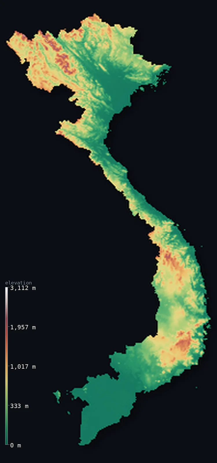
Vietnam’s highest point is Fansipan (Phan Xi Pang) at 10,325 ft (3,147 m); its lowest is South China Sea at 0 ft (0 m); the mean elevation is 1,273 ft (388 m).
Vietnam is shaped like an S, and the shape is the story. At each end lies a vast flat delta — the Red River in the north, the Mekong in the south — and between them stretches a narrow waist where mountains crowd almost to the sea. Nearly half the country sits below 656 ft (200 m) in those two deltas and the coastal strip, which is why the median elevation, 807 ft (246 m), falls so far below the mean of 1,273 ft (388 m): the flat ground is where Vietnam lives.
- Highest point📚
- 10,325 ft3,147 m
- Vietnam's highest point is Fansipan at 10,325 ft (3,147 m), in the far northwest near the Chinese border — the highest peak in Indochina, standing at the southeastern end of the ranges that run down out of the Himalaya.
- Lowest point📚
- 0 ft0 m
- Vietnam's lowest point is the sea, along a coastline of more than 3,000 km — though the more telling low ground is the Mekong Delta, an enormous plain lying only a metre or two above the tide across thousands of square kilometres.
- Mean elevation⚙
- 1,273 ft388 m
- Vietnam's mean elevation computed from the GLO-30 model is 1,273 ft (388 m) — a figure that sits between the country's two halves rather than describing either: the mountainous interior pulls it up, the two deltas pull it down.
- Median elevation⚙
- 807 ft246 m
- Half of Vietnam lies below 807 ft (246 m) — well under the mean, and the clearest measure of the country's shape: the deltas and the coastal plain, where most Vietnamese live, occupy a huge share of the land while the high ground is packed into the northwest and the inland spine.
- Elevation range📚
- 10,325 ft3,147 m
- From the sea to Fansipan, Vietnam spans about 10,300 ft — and the country is so narrow through its middle that in places the mountains and the coast are less than 50 km apart.
- Above 1,000 m (3,281 ft)⚙
- 10%
- About 10% of Vietnam rises above 1,000 m (3,281 ft) — the northwestern ranges around Fansipan and the higher parts of the Annamite spine and the Central Highlands.
- Official area📚
- 127,881 mi²331,210 km²
- Vietnam covers about 128,000 sq mi (331,210 sq km), stretched more than 1,600 km from north to south along the eastern edge of the Indochinese peninsula — long enough that its two deltas sit in different climates.
- Forest cover📚
- 46.7%
- About 47% of Vietnam is forested — concentrated in the mountainous north and along the Annamite range, while the deltas are almost entirely farmed.
Highest and lowest points
Vietnam's highest point is Fansipan, 10,325 ft (3,147 m), in the Hoang Lien Son range of the far northwest near Sa Pa — the highest mountain in Indochina, and the culmination of ranges that run southeast out of the eastern Himalaya. It stands a long way from the rest of the country's high ground: the Annamite mountains that form Vietnam's long inland spine rarely exceed 2,000 m.
source ↗Vietnam's lowest point is sea level, but the number understates what that means here. The Mekong Delta in the south is a plain of some 40,000 sq km lying barely above the tide — a maze of distributaries, canals, and rice paddies that produces much of the country's food and is home to tens of millions of people. It is among the places on Earth most exposed to sea-level rise: a rise measured in tens of centimetres would reach far inland across ground this flat.
source ↗Vietnam at a glance
Fansipan, 3,147 m, is the highest mountain not just in Vietnam but in all of Indochina.
source ↗Vietnam's two great deltas - the Red River in the north and the Mekong in the south - hold most of the country's population on ground barely above sea level.
source ↗Through its narrow middle, Vietnam is less than 50 km wide in places, with mountains coming almost to the coast.
source ↗The Mekong Delta covers around 40,000 sq km at barely a metre or two above the tide, making it one of the regions most vulnerable to sea-level rise on Earth.
source ↗The Annamite range forms Vietnam's long inland spine and much of its border with Laos, running most of the country's length.
source ↗The Central Highlands are a series of basalt plateaus in the south-centre, raised well above the coastal plain and covered in volcanic red soils.
source ↗A 2019 survey found Fansipan about 4 m higher than the 1909 value.
source ↗
Elevation profile of Vietnam
The largest share of land, 46%, falls in the 0–200 m band, and 68% of the territory lies below 500 m (1,640 ft).
- below 500 m (1,640 ft)68%
- 500–1,000 m23%
- 1,000–2,000 m9%
- above 2,000 m (6,562 ft)<1%
Highest peaks of Vietnam
| Peak | Elevation | Range | Note |
|---|---|---|---|
| Fansipan (Phan Xi Pang)↗ | 10,325 ft3,147 m | Hoang Lien Son | Highest point of Vietnam and of Indochina, in the far northwest near Sa Pa. |
| Pu Si Lung↗ | 10,115 ft3,083 m | Northwest highlands | A high peak right on the Chinese border in Lai Chau, among the tallest in Vietnam. |
| Pu Ta Leng↗ | 10,003 ft3,049 m | Hoang Lien Son | A neighbour of Fansipan in the Hoang Lien Son, famed for its rhododendrons. |
| Ky Quan San (Bach Moc Luong Tu)↗ | 9,993 ft3,046 m | Northwest highlands | A high ridge on the Lao Cai-Lai Chau boundary, popular with trekkers. |
| Ngoc Linh↗ | 8,524 ft2,598 m | Central Highlands (Truong Son) | The highest peak of the Central Highlands and of southern Vietnam. |
Two deltas and a spine
The Red River Delta (north)
The northern lowland is the delta of the Red River — flat, intensively farmed, and densely populated, with Hanoi at its centre. Behind it the land rises quickly into the northern hills.
The northwestern mountains
Vietnam's highest ground lies in the far northwest, where ranges running out of the eastern Himalaya carry Fansipan and the country's only terrain above 3,000 m — steep, deeply cut, and sparsely settled.
The Annamite spine and the narrow centre
Down the country's long middle runs the Annamite range, forming much of the border with Laos and squeezing the coastal plain to a strip. This is where Vietnam is at its narrowest — mountains on one side, sea on the other, with only a thread of flat land between.
The Central Highlands and the Mekong Delta (south)
Inland in the south rise the Central Highlands, basalt plateaus of red volcanic soil raised above the coast. Beyond them the land falls away into the Mekong Delta — enormous, flat, and barely above the tide, the agricultural heart of the country.
How to read this map
Color shows elevation; the raised relief shows real terrain. On this map Vietnam reads as a green S — flat deltas at each end, a brown mountain spine running the length of the interior, and white only in the far northwest around Fansipan.
The 3D relief is the actual GLO-30 elevation data, exaggerated vertically so both the delta flatness and the narrow spine show; the ×N relief slider controls how much. Tap anywhere to read that point's exact elevation.
City elevations in Vietnam
Vietnam's cities sit on the deltas and the coast - Hanoi on the Red River plain, Ho Chi Minh City at the head of the Mekong Delta, both only a few metres above the tide. Away from the water the country climbs fast, and its highland towns are small.
| City | Population | Elevation |
|---|---|---|
| Ho Chi Minh Cityat the northern edge of the Mekong Delta, barely above sea level ↗ | 14,002,598 | 23 ft7 m |
| Hanoicapitalthe capital, on the flat Red River delta a few metres above the tide ↗ | 8,053,663 | 46 ft14 m |
| Cần Thơ | 1,507,187 | 23 ft7 m |
| Huế | 1,380,000 | 23 ft7 m |
| Thanh Hóa | 850,000 | 16 ft5 m |
| Vinh | 790,000 | 30 ft9 m |
| Nha Trang | 579,000 | 33 ft10 m |
| Qui Nhon | 519,208 | 26 ft8 m |
| Buôn Ma Thuột | 434,256 | 1,509 ft460 m |
| Phu Quoc | 294,419 | 36 ft11 m |
Elevation sampled at each city centre from the Copernicus GLO-30 model. Cities and population from GeoNames (CC-BY 4.0).
Vietnam in comparison
Vietnam's terrain rises 10,325 ft (3,147 m) from sea level to Fansipan (Phan Xi Pang) — about 36% of the height of Mount Everest, the world's highest point at 29,032 ft (8,849 m).
- Laos's mean elevation is 2,188 ft — 915 ft higher; its high point, Phou Bia, reaches 9,249 ft (2,819 m), 1,076 ft below. Laos elevation map →
- Cambodia's mean elevation is 404 ft — 869 ft lower; its high point, Phnom Aural, reaches 5,938 ft (1,810 m), 4,386 ft below. Cambodia elevation map →
- Thailand's mean elevation is 932 ft — 341 ft lower; its high point, Doi Inthanon, reaches 8,415 ft (2,565 m), 1,909 ft below. Thailand elevation map →
Frequently asked questions
What is the highest point in Vietnam?
- Fansipan, 10,325 ft (3,147 m), in the northwestern Hoang Lien Son range - the highest mountain in Indochina.
What is the lowest point in Vietnam?
- Sea level - and the Mekong Delta in the south sits barely a metre or two above it across an enormous area.
What is the average elevation of Vietnam?
- Computed from the Copernicus GLO-30 model, the area-weighted mean is 1,273 ft (388 m) - though half the country lies below about 246 m, since the two deltas hold so much of the land.
Why is Vietnam shaped like an S?
- Two broad river deltas - the Red River in the north and the Mekong in the south - are joined by a long, narrow middle where the Annamite mountains push the coastal plain to a strip sometimes less than 50 km wide.
Is the Mekong Delta at risk from sea-level rise?
- It is among the most exposed regions on Earth - some 40,000 sq km of it lie barely above the tide, so even a modest rise reaches far inland.
Is this a topographic, relief, contour, or elevation map of Vietnam?
- They describe the same thing - terrain height. This page renders the country's actual elevation surface in interactive 3D and reports the statistics computed from it.
About this map
The terrain is rendered from the Copernicus GLO-30 digital elevation model (ESA), masked to the VNM-ADM0 boundary from geoBoundaries (gbOpen). Elevation statistics are computed directly from the model; peak names and researched facts are sourced and cited. See the methodology for the full pipeline.
Our area-weighted mean, computed from the Copernicus GLO-30 model, is 1,273 ft (388 m); the figure commonly cited elsewhere is 1,306 ft (398 m) (CIA World Factbook). Vietnam is a long, narrow country of mountains and hills down its western and northern spine but broad low deltas at each end - the Red River in the north and the Mekong in the south - giving a modest mean; the page reports the area-weighted figure computed from the Copernicus GLO-30 model.
Surveyed national figures: official area · forest cover · high point.
Rendered from Copernicus GLO-30 (ESA, 2021 release), boundaries from geoBoundaries. Generated 2026-07-08.
Bordering countries · 3
Vietnam shares a land border with these countries — open any one to compare its terrain and highest point.