China Elevation Map — Topographic & 3D Terrain
Explore the terrain of China in interactive 3D, built from Copernicus GLO-30 satellite elevation data — a country that descends in three great steps from the roof of the world to the sea. Drag to rotate, scroll to zoom, and tap any point to read its elevation.
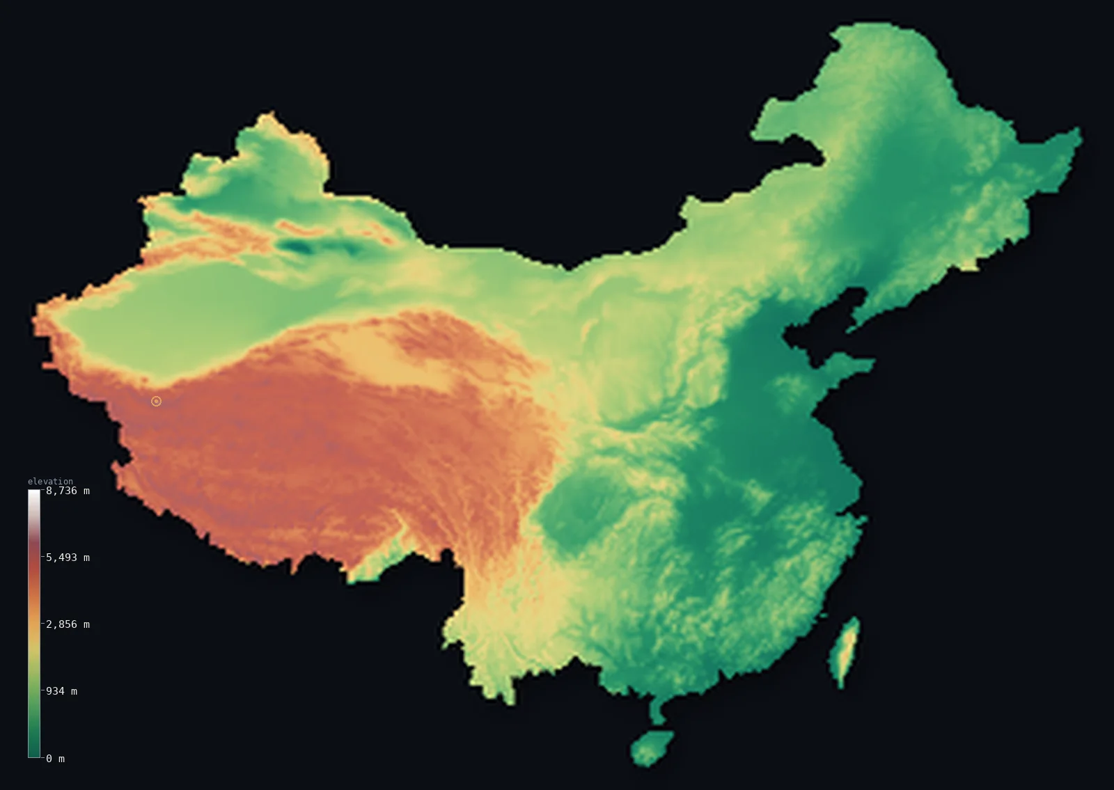
China’s highest point is Mount Everest (Qomolangma) at 29,032 ft (8,849 m); its lowest is Ayding Lake, Turpan Depression at −505 ft (−154 m); the mean elevation is 6,014 ft (1,833 m).
China descends from west to east in three enormous steps. It begins on the Tibetan Plateau — the highest and largest plateau on Earth — falls to the basins and deserts of the interior, and finally flattens into the eastern lowlands where most of its people live. That western mass lifts the whole country's average to 6,014 ft (1,833 m), and China holds both the summit of Everest at 29,032 ft (8,849 m) and, 3,000 km away, the Turpan Depression at 505 ft (154 m) below sea level.
- Highest point📚
- 29,032 ft8,849 m
- China's highest point is the summit of Mount Everest — Qomolangma — at 29,032 ft (8,849 m), the highest point on Earth, standing on the border with Nepal. The two countries share the summit and jointly fixed its official height in 2020.
- Lowest point📚
- −505 ft−154 m
- China's lowest point is Ayding Lake in the Turpan Depression, 505 ft (154 m) below sea level — a dry salt flat in the far northwestern deserts, one of the deepest continental depressions in the world and one of the hottest places in Asia.
- Mean elevation⚙
- 6,014 ft1,833 m
- China's mean elevation computed from the GLO-30 model is 6,014 ft (1,833 m) — extraordinarily high for a country of this size, and almost entirely the work of the west: the Tibetan Plateau alone covers a quarter of the country at over 4,000 m.
- Median elevation⚙
- 3,825 ft1,166 m
- Half of China lies above 3,825 ft (1,166 m), far above the level where most Chinese actually live — because the vast, thinly populated western highlands occupy so much of the map while the crowded eastern plains take up comparatively little.
- Elevation range📚
- 29,537 ft9,003 m
- From Ayding Lake, 154 m below sea level, to the summit of Everest, China spans nearly 29,600 ft of vertical relief — the greatest range of elevation within any single country on Earth.
- Above 1,000 m (3,281 ft)⚙
- 57%
- About 57% of China lies above 1,000 m (3,281 ft) — a majority of the country, taking in the whole western half: the Tibetan Plateau, the Kunlun and Tian Shan ranges, and the high basins between them.
- Above 2,000 m (6,562 ft)⚙
- 32%
- Roughly 32% of China stands above 2,000 m (6,562 ft), and about a quarter above 3,000 m — a share driven almost wholly by the Tibetan Plateau, which is high enough that the air holds barely half the oxygen of sea level.
- Official area📚
- 3,705,405 mi²9,596,960 km²
- China covers about 3.7 million sq mi (9.6 million sq km) — a span wide enough to hold the world's highest plateau, three of its longest rivers, and some of its most crowded lowland at the same time.
- Forest cover📚
- 22.3%
- About 22% of China is forested — a modest share for so large a country, because the western half is high desert, steppe, and bare plateau, and the fertile east has been farmed for thousands of years.
Highest and lowest points
China's highest point is the summit of Mount Everest — known in China as Qomolangma — at 29,032 ft (8,849 m), on the border with Nepal in the Himalaya. The summit is shared: both countries claim it, and in 2020 they jointly surveyed the mountain and agreed on its official height of 8,848.86 m. The northern, Tibetan side is the route by which the peak was long approached from China.
source ↗China's lowest point is Ayding Lake in the Turpan Depression of Xinjiang, 505 ft (154 m) below sea level — a hard salt flat that is usually dry, ringed by desert, and one of the hottest places in Asia in summer. It is one of the deepest inland depressions on the planet, and it lies in the same country as the highest mountain on Earth: no other nation contains so wide a gap between its floor and its ceiling.
source ↗China at a glance
China contains both the highest point on Earth - the summit of Everest, shared with Nepal at 8,849 m - and one of the deepest inland depressions, Ayding Lake at 154 m below sea level.
source ↗The Tibetan Plateau, often called the roof of the world, covers about a quarter of China at an average elevation over 4,000 m - the highest and largest plateau on the planet.
source ↗China's terrain descends from west to east in three great steps, from the Tibetan Plateau through the interior basins to the eastern coastal plains.
source ↗About 57% of China lies above 1,000 m, yet the great majority of its people live on the low eastern plains that make up a much smaller share of the land.
source ↗The Yangtze and Yellow rivers both rise on the Tibetan Plateau and run east across the whole country to the sea, falling thousands of metres on the way.
source ↗The Turpan Depression, where China's low point lies, is one of the hottest and driest places in Asia, and sits within sight of the snow-capped Tian Shan.
source ↗
Elevation profile of China
The largest share of land, 27%, falls in the 0–500 m band, and 73% of the territory lies above 500 m (1,640 ft).
- below 500 m (1,640 ft)27%
- 500–1,000 m16%
- 1,000–2,000 m25%
- above 2,000 m (6,562 ft)32%
Highest peaks of China
| Peak | Elevation | Range | Note |
|---|---|---|---|
| Mount Everest (Qomolangma)↗ | 29,032 ft8,849 m | Himalayas | Highest point of China and of Earth, on the Nepalese border. |
| K2 (Qogir)↗ | 28,251 ft8,611 m | Karakoram | The world's second-highest mountain, on China's border with Pakistan. |
| Lhotse↗ | 27,940 ft8,516 m | Himalayas | The fourth-highest mountain on Earth, beside Everest on the Nepalese border. |
| Cho Oyu↗ | 26,864 ft8,188 m | Himalayas | The sixth-highest mountain in the world, on the China-Nepal border. |
| Gongga Shan (Minya Konka)↗ | 24,790 ft7,556 m | Daxue Shan (Hengduan) | The highest peak of Sichuan and easternmost of the great 7,000 m summits, well inside China. |
China's three steps
The western highlands (the first step)
The west of China is the Tibetan Plateau, the highest and largest plateau on Earth, averaging over 4,000 m and rimmed by the Himalaya, the Kunlun, and the Tian Shan. Cold, thin-aired and thinly peopled, it covers about a quarter of the country and lifts China's whole average elevation.
The northwestern basins and deserts (the second step)
Stepping down from the plateau are the interior basins and deserts — the Tarim with the Taklamakan, the Junggar, the Ordos — along with the Loess Plateau and Inner Mongolian steppe. This middle tier holds China's driest ground, including the Turpan Depression, which drops below sea level.
The eastern lowlands (the third step)
The final step is the low eastern third of the country — the North China Plain, the middle and lower Yangtze basins, and the coastal hills and deltas. It is a small share of China's area but holds the great bulk of its people, its farmland, and its cities.
How to read this map
Color shows elevation; the raised relief shows real terrain. On this map China reads as a bright white-and-brown mass in the west — the Tibetan Plateau — stepping down through browns and yellows to the green lowlands of the east coast.
The 3D relief is the actual GLO-30 elevation data, exaggerated vertically so the plateau's edge and the eastern plains both show; the ×N relief slider controls how much. Tap anywhere to read that point's exact elevation.
City elevations in China
China's great cities sit almost entirely on the low eastern third of the country - Shanghai at the Yangtze mouth barely above sea level, Beijing on the North China Plain. Only inland cities like Chengdu, on the Sichuan Basin floor, rise even modestly toward the western steps.
| City | Population | Elevation |
|---|---|---|
| Shanghaiat the mouth of the Yangtze on the flat coastal delta, barely above sea level ↗ | 24,874,500 | 16 ft5 m |
| Beijingcapitalthe capital, on the North China Plain near the northern edge of the eastern lowlands ↗ | 18,960,744 | 154 ft47 m |
| Shenzhen | 17,494,398 | 33 ft10 m |
| Chengduon the floor of the Sichuan Basin, the sheltered lowland below the eastern edge of the plateau ↗ | 13,568,357 | 1,640 ft500 m |
| Wuhan | 10,392,693 | 75 ft23 m |
| Xi’an | 9,600,000 | 1,352 ft412 m |
| Nanjing | 9,314,685 | 66 ft20 m |
| Hangzhou | 9,236,032 | 30 ft9 m |
| Taipei | 7,871,900 | 36 ft11 m |
| Chongqing | 7,457,599 | 919 ft280 m |
Elevation sampled at each city centre from the Copernicus GLO-30 model. Cities and population from GeoNames (CC-BY 4.0).
China in comparison
China's terrain rises 29,537 ft (9,003 m) — from Ayding Lake, Turpan Depression, 505 ft (154 m) below sea level to the summit of Mount Everest (Qomolangma) itself, the highest point on Earth.
- India's mean elevation is 2,306 ft — 3,707 ft lower; its high point, K2 (Godwin-Austen), reaches 28,251 ft (8,611 m), 781 ft below. India elevation map →
- Mongolia's mean elevation is 4,875 ft — 1,138 ft lower; its high point, Khuiten Peak, reaches 14,350 ft (4,374 m), 14,682 ft below. Mongolia elevation map →
- Nepal's mean elevation is 6,929 ft — 915 ft higher; its high point, Mount Everest (Sagarmatha), reaches 29,032 ft (8,849 m), 0 ft above. Nepal elevation map →
Frequently asked questions
What is the highest point in China?
- The summit of Mount Everest (Qomolangma), 29,032 ft (8,849 m), on the border with Nepal - the highest point on Earth, its summit shared between the two countries.
What is the lowest point in China?
- Ayding Lake in the Turpan Depression, 505 ft (154 m) below sea level - a dry salt flat in the northwestern deserts and one of the deepest inland depressions on the planet.
What is the average elevation of China?
- Computed from the Copernicus GLO-30 model, the area-weighted mean is 6,014 ft (1,833 m) - very high for a country this size, because the Tibetan Plateau covers roughly a quarter of it above 4,000 m.
Why is western China so much higher than eastern China?
- China descends in three great steps: the Tibetan Plateau in the west, the interior basins and deserts in the middle, and the low coastal plains in the east, where most of the population lives.
How big is the Tibetan Plateau?
- It covers roughly a quarter of China at an average elevation above 4,000 m - the highest and largest plateau on Earth, often called the roof of the world.
Is this a topographic, relief, contour, or elevation map of China?
- They describe the same thing - terrain height. This page renders the country's actual elevation surface in interactive 3D and reports the statistics computed from it.
About this map
The terrain is rendered from the Copernicus GLO-30 digital elevation model (ESA), masked to the CHN-ADM0 boundary from geoBoundaries (gbOpen). Elevation statistics are computed directly from the model; peak names and researched facts are sourced and cited. See the methodology for the full pipeline.
Because China covers 9,481,461 km², its 3D terrain surface is rendered at roughly 2.7 km per pixel rather than the model’s native 30 m — the full-resolution grid exceeds the render budget for an area this large. The high point and every elevation figure on this page are still measured at native 30 m resolution; only the rendered surface detail is coarsened.
Our area-weighted mean, computed from the Copernicus GLO-30 model, is 6,014 ft (1,833 m); the figure commonly cited elsewhere is 6,037 ft (1,840 m) (CIA World Factbook). China's land descends like a staircase from the towering Tibetan Plateau in the west to the coastal plains in the east, giving a high mean; the page reports the area-weighted figure computed from the Copernicus GLO-30 model, shown at reduced surface resolution for a country this large.
Surveyed national figures: official area · forest cover · high point.
Rendered from Copernicus GLO-30 (ESA, 2021 release), boundaries from geoBoundaries. Generated 2026-07-12.
Bordering countries · 14
China shares a land border with these countries — open any one to compare its terrain and highest point.
- Afghanistan↑ Noshaq, 7,492 m
- Bhutan↑ Gangkhar Puensum, 7,570 m
- India↑ K2 (Godwin-Austen), 8,611 m
- Kazakhstan↑ Khan Tengri, 7,010 m
- Kyrgyzstan↑ Jengish Chokusu (Victory Peak), 7,439 m
- Laos↑ Phou Bia, 2,819 m
- Mongolia↑ Khuiten Peak, 4,374 m
- Myanmar↑ Hkakabo Razi, 5,881 m
- Nepal↑ Mount Everest (Sagarmatha), 8,849 m
- North Korea↑ Paektu (Janggun Peak), 2,744 m
- Pakistan↑ K2 (Mount Godwin-Austen), 8,611 m
- Russia↑ Mount Elbrus, 5,642 m
- Tajikistan↑ Ismoil Somoni Peak, 7,495 m
- Vietnam↑ Fansipan (Phan Xi Pang), 3,147 m