Nepal Topographic & Elevation Map
Explore the terrain of Nepal in interactive 3D, built from Copernicus GLO-30 satellite elevation data — from the Terai plain to the crest of the Himalaya. Drag to rotate, scroll to zoom, and tap any point to read its elevation.
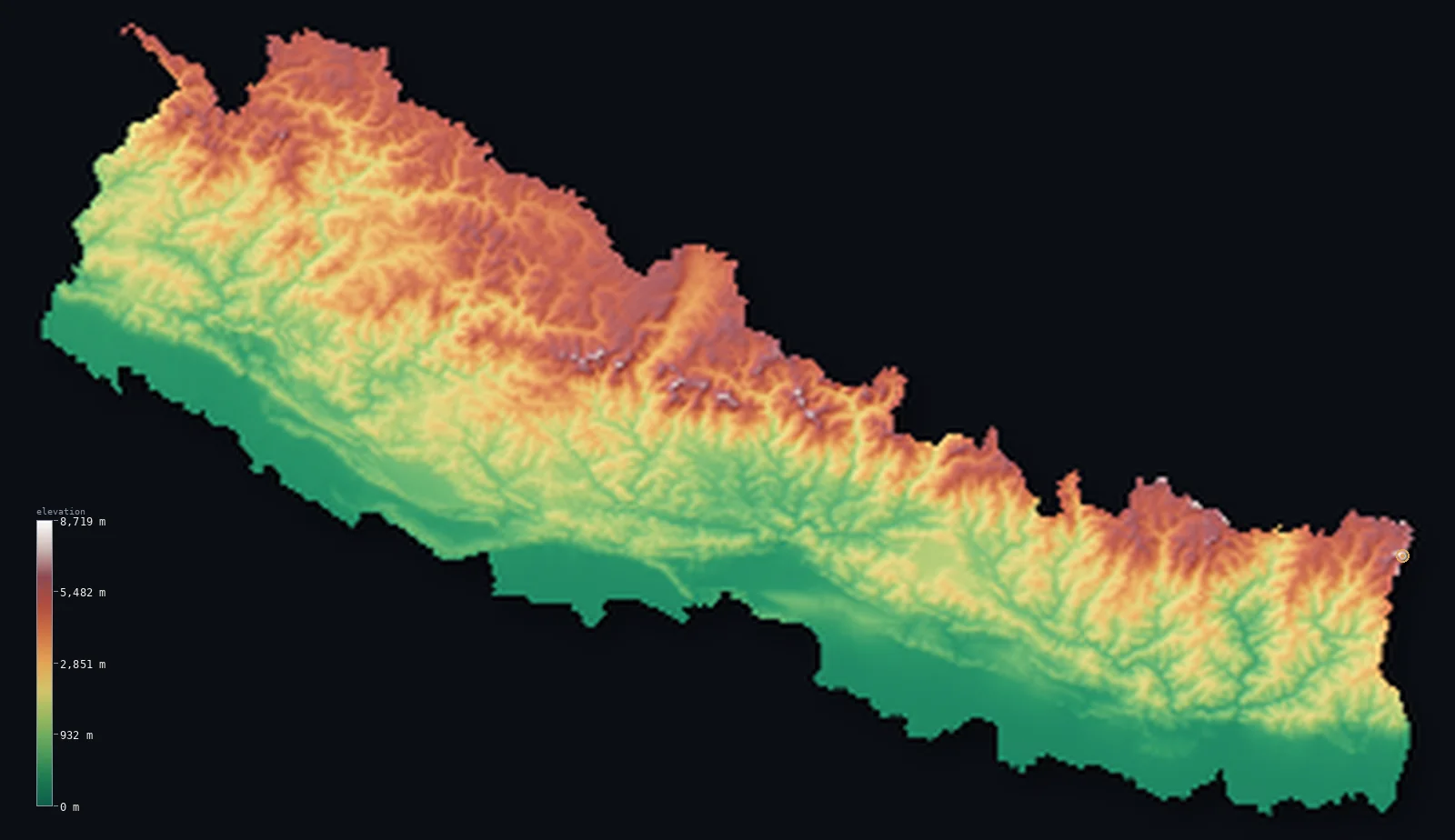
Nepal’s highest point is Mount Everest (Sagarmatha) at 29,032 ft (8,849 m); its lowest is Kanchan Kalan at 230 ft (70 m); the mean elevation is 6,929 ft (2,112 m).
Nepal rises from the 230 ft (70 m) Terai plain in the far south to Mount Everest at 29,032 ft (8,849 m) on the northern border — nearly 8.8 km of vertical relief packed into roughly 200 km. Its computed mean elevation is 6,929 ft (2,112 m), and eight of the world's fourteen peaks above 8,000 m stand along its northern rim. Few landscapes on Earth climb so far, so fast.
- Highest point📚
- 29,032 ft8,849 m
- Nepal's high point is the high point of the planet: Mount Everest, 29,032 ft (8,849 m), standing exactly on the Nepal–China border — a summit so far above the rest of the country that climbers spend weeks just acclimatising to reach it.
- Lowest point📚
- 230 ft70 m
- Nepal's lowest ground is the Terai plain in the far south, only about 230 ft (70 m) above sea level — so the land climbs more than 8,700 m from there to Everest's summit across a country barely 200 km deep, the steepest sustained rise of any nation on Earth.
- Mean elevation⚙
- 6,929 ft2,112 m
- Nepal's computed mean elevation is 6,929 ft (2,112 m), and it is often named the highest-averaged country on Earth — a title it owes not to any one peak but to the simple fact that the Himalaya and their foothills occupy the entire northern half of the country, leaving little low ground to pull the average down.
- Median elevation⚙
- 5,197 ft1,584 m
- It surprises people that half of Nepal lies below 5,197 ft (1,584 m): the eight-thousanders own the imagination, but the country's true center of gravity is the Middle Hills — the terraced ridge country where most Nepalis actually live, well below the snow line.
- Elevation range📚
- 28,802 ft8,779 m
- From the 70 m Terai plain to Everest's 8,849 m summit, Nepal rises more than 8,700 m across a span only about 200 km wide — nowhere else on Earth does the land climb so far, so fast, packing tropical lowland and permanent ice into a single day's drive.
- Above 1,000 m (3,281 ft)⚙
- 65%
- About 65% of Nepal lies above 1,000 m (3,281 ft) — but that figure undersells it, because what counts as high mountain elsewhere is merely Nepal's inhabited middle, the hill country between the plains and the peaks.
- Above 2,000 m (6,562 ft)⚙
- 42%
- Roughly 42% of Nepal sits above 2,000 m (6,562 ft), a share almost no other country approaches: where 2,000 m marks the high ground in most of the world, in Nepal it is simply where the Middle Hills end and the true mountains begin.
- Official area📚
- 56,827 mi²147,181 km²
- Nepal covers only about 56,827 sq mi (147,181 sq km) — smaller than many single American states — yet within that compact frame it holds eight of the fourteen highest peaks on Earth, and climbs from subtropical plain to the summit of Everest in under 200 km.
- Forest cover📚
- 41.6%
- About 41.6% of Nepal is forest, and because the land climbs so fast, that one figure spans climates most countries never contain: subtropical sal on the Terai, rhododendron and pine through the Middle Hills, thinning to a tree line that gives out well before the summits.
Highest and lowest points
The highest point of Nepal - and of the Earth - is Mount Everest (Sagarmatha; Tibetan Chomolungma), 8,848.86 m by the 2020 joint Nepal-China survey. Its summit sits exactly on the Nepal-China (Tibet) border in the Mahalangur Himal, so it is a border summit, shared with China.
source ↗The lowest point of Nepal lies on the Terai plain in the far south, around 230 ft (70 m) above sea level near Kanchan Kalan. This flat, fertile lowland is the northern edge of the great Gangetic plain — warm, humid, and densely farmed, a world away from the ice of the high Himalaya only about 200 km to the north.
source ↗Nepal at a glance
Nepal holds eight of the world's fourteen mountains above 8,000 m, including Everest - more than any other country.
source ↗Its elevation runs from about 70 m on the Terai plain to 8,849 m at Everest - a vertical span of nearly 8.8 km within roughly 200 km north to south.
source ↗Mount Everest's summit sits precisely on the Nepal-China border; climbers approach from both the Nepali and Tibetan sides.
source ↗Everest's height was fixed at 8,848.86 m only in 2020, after a joint Nepal-China survey ended decades of dispute over rock-versus-snow height.
source ↗Nepal has the highest mean elevation of any country, the result of the Himalaya covering its entire northern third.
source ↗The Himalaya are still rising a few millimetres a year as the Indian Plate pushes under Eurasia.
source ↗
Elevation profile of Nepal
The largest share of land, 35%, falls in the 0–1,000 m band, and 77% of the territory lies above 500 m (1,640 ft).
- below 500 m (1,640 ft)23%
- 500–1,000 m13%
- 1,000–2,000 m22%
- above 2,000 m (6,562 ft)42%
Highest peaks of Nepal
| Peak | Elevation | Range | Note |
|---|---|---|---|
| Mount Everest (Sagarmatha)↗ | 29,032 ft8,849 m | Mahalangur Himal (China border) | The highest mountain on Earth, a border summit shared with China (Tibet). |
| Kangchenjunga↗ | 28,169 ft8,586 m | Kangchenjunga Himal (east, India border) | The third-highest mountain on Earth, on the eastern border with India. |
| Lhotse↗ | 27,940 ft8,516 m | Mahalangur Himal (China border) | The fourth-highest mountain, joined to Everest by the South Col. |
| Makalu↗ | 27,838 ft8,485 m | Mahalangur Himal (China border) | The fifth-highest mountain, a sharp pyramid east of Everest. |
| Cho Oyu↗ | 26,864 ft8,188 m | Mahalangur Himal (Nepal-China border) | The sixth-highest mountain on Earth, on the border with China (Tibet). |
| Dhaulagiri I↗ | 26,795 ft8,167 m | Dhaulagiri Himal (central) | The seventh-highest mountain, lying wholly within Nepal west of the Kali Gandaki. |
| Manaslu↗ | 26,781 ft8,163 m | Mansiri Himal (central Nepal) | The eighth-highest mountain on Earth, in the Mansiri Himal of central Nepal. |
| Annapurna I↗ | 26,545 ft8,091 m | Annapurna Himal (central Nepal) | The tenth-highest mountain on Earth, in the Annapurna Himal of central Nepal. |
The three terrain belts of Nepal, south to north
The Terai and Siwaliks (South)
Nepal begins at its lowest and warmest ground: the Terai, a flat alluvial plain along the Indian border that falls to the country's low point near 230 ft (70 m). It is the northern edge of the Indo-Gangetic lowland — Nepal's most fertile farm belt. Behind it rise the Siwalik (Churia) Hills, the youngest and outermost Himalayan range, enclosing the flat-floored 'Inner Terai' valleys.
The Middle Hills (Centre)
Across the centre runs the broad belt of the Middle Hills — the Mahabharat Range and midlands, mostly 3,300–9,800 ft (1,000–3,000 m), terraced and densely settled. This is the historic heartland, holding the Kathmandu and Pokhara valleys. The great rivers — Koshi, Gandaki and Karnali — cut south through the hills in deep gorges on their way from the Himalaya to the Ganges.
The Great Himalaya (North)
The north is walled by the Great Himalaya, which carries eight of the world's fourteen peaks above 8,000 m — Everest, Kangchenjunga, Lhotse, Makalu, Cho Oyu, Dhaulagiri, Manaslu and Annapurna — under permanent snow and ice. Beyond the main crest lie the high, dry trans-Himalayan valleys of Mustang and Dolpo, in the range's rain shadow on the edge of the Tibetan Plateau.
How to read this map
Color shows elevation; the raised relief shows real terrain. The bands run from green on the Terai up through browns to white on the snow peaks — the same idea as the contour lines on a topographic map, drawn as a continuous surface.
The 3D relief is the actual GLO-30 elevation data, exaggerated vertically so the Middle Hills stay legible beneath the 8,000 m giants; the ×N relief slider controls how much. Tap anywhere on the map to read that point's exact elevation.
City elevations in Nepal
Nepal's cities are stacked up the country's ascent. On the Terai, Biratnagar and Birganj sit barely above sea level near 233 ft (71 m); the capital, Kathmandu, fills a Middle-Hills valley at about 4,239 ft (1,292 m); and Pokhara rests beneath the Annapurna wall, one of the steepest mountain backdrops of any city on Earth.
| City | Population | Elevation |
|---|---|---|
| KathmanducapitalKathmandu, the capital, in a fertile valley among the Middle Hills, ringed by foothills. ↗ | 1,442,271 | 4,239 ft1,292 m |
| PokharaPokhara lies in a hill valley directly beneath the Annapurna massif, with one of the steepest mountain backdrops on Earth. ↗ | 600,051 | 3,284 ft1,001 m |
| Bharatpurin the Inner Terai lowlands on the Narayani River, gateway to Chitwan ↗ | 369,377 | 692 ft211 m |
| Birgañja Terai border city on the Indian frontier, a main trade gateway to Nepal ↗ | 268,273 | 276 ft84 m |
| Biratnagaron the southeastern Terai plain near India - one of Nepal's lowest and hottest cities ↗ | 244,750 | 233 ft71 m |
| Dhangadhia far-western Terai city on the plains near the Indian border ↗ | 204,788 | 594 ft181 m |
| Janakpuron the southern Terai plain, an ancient pilgrimage city near India ↗ | 195,438 | 266 ft81 m |
| Butwālat the very foot of the hills, where the plains meet the Siwalik front ↗ | 195,054 | 1,066 ft325 m |
| Nepalgunja hot Terai border city in the west, close to India ↗ | 166,258 | 499 ft152 m |
| Birendranagarin an Inner Terai valley in the western hills, above the plains - also known as Surkhet ↗ | 154,886 | 2,270 ft692 m |
Elevation sampled at each city centre from the Copernicus GLO-30 model. Cities and population from GeoNames (CC-BY 4.0).
Nepal in comparison
Nepal's terrain rises 28,802 ft (8,779 m) from Kanchan Kalan (230 ft (70 m)) to Mount Everest (Sagarmatha) — about 99% of the height of Mount Everest, the world's highest point at 29,032 ft (8,849 m).
- China's mean elevation is 6,014 ft — 915 ft lower; its high point, Mount Everest (Qomolangma), reaches 29,032 ft (8,849 m), 0 ft above. China elevation map →
- India's mean elevation is 2,306 ft — 4,623 ft lower; its high point, K2 (Godwin-Austen), reaches 28,251 ft (8,611 m), 781 ft below. India elevation map →
- Bhutan's mean elevation is 9,354 ft — 2,425 ft higher; its high point, Gangkhar Puensum, reaches 24,836 ft (7,570 m), 4,196 ft below. Bhutan elevation map →
Frequently asked questions
What is the highest point in Nepal?
- Mount Everest (Sagarmatha), 29,032 ft (8,849 m), on the China border - the highest point on Earth.
What is the average elevation of Nepal?
- Computed from the Copernicus GLO-30 model, the area-weighted mean is 6,929 ft (2,112 m). Nepal has the highest mean elevation of any country.
What is the lowest point in Nepal?
- About 70 m, on the Terai plain in the far south - Nepal is landlocked, so it never reaches the sea.
How tall is Mount Everest?
- 8,848.86 m, fixed by the 2020 joint Nepal-China survey. On this 30 m elevation model the sharp summit reads slightly lower, since each grid cell averages the terrain.
How many 8,000 m peaks are in Nepal?
- Eight of the world's fourteen - Everest, Kangchenjunga, Lhotse, Makalu, Cho Oyu, Dhaulagiri, Manaslu and Annapurna.
Is this a topographic, relief, contour, or elevation map of Nepal?
- They describe the same thing - terrain height. This page renders Nepal's actual elevation surface in interactive 3D (a relief or topographic view) and reports the elevation statistics computed from it; a contour map shows the same data as lines of equal height.
About this map
The terrain is rendered from the Copernicus GLO-30 digital elevation model (ESA), masked to the NPL-ADM0 boundary from geoBoundaries (gbOpen). Elevation statistics are computed directly from the model; peak names and researched facts are sourced and cited. See the methodology for the full pipeline.
Our area-weighted mean, computed from the Copernicus GLO-30 model, is 6,929 ft (2,112 m); the figure commonly cited elsewhere is 10,712 ft (3,265 m) (CIA World Factbook). Nepal climbs from the low Terai plain in the south across the Middle Hills to the Great Himalaya in the north, holding eight of the world's fourteen peaks above 8,000 m, so its mean elevation is the highest of any country; the page reports the area-weighted figure computed from the Copernicus GLO-30 model.
Surveyed national figures: official area · forest cover · high point.
Rendered from Copernicus GLO-30 (ESA, 2021 release), boundaries from geoBoundaries. Generated 2026-06-25.
Bordering countries · 2
Nepal shares a land border with these countries — open any one to compare its terrain and highest point.