Bhutan Elevation Map — Topographic & 3D Terrain
Explore the terrain of Bhutan in interactive 3D, built from Copernicus GLO-30 satellite elevation data — a small kingdom that is almost entirely mountain. Drag to rotate, scroll to zoom, and tap any point to read its elevation.
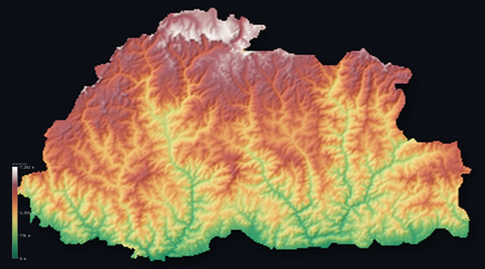
Bhutan’s highest point is Gangkhar Puensum at 24,836 ft (7,570 m); its lowest is Drangme Chhu (river) at 318 ft (97 m); the mean elevation is 9,354 ft (2,851 m).
Bhutan is a kingdom of mountains with almost no flat ground at all. Half the country lies above 9,173 ft (2,796 m) — one of the highest median elevations on Earth — and it rises to 24,836 ft (7,570 m) at Gangkhar Puensum, the highest mountain that has never been climbed. Where its neighbour Nepal spreads from a wide lowland plain up to the peaks, Bhutan is nearly all high country, cut by deep river valleys, its summits closed to climbers by law.
- Highest point📚
- 24,836 ft7,570 m
- Bhutan's highest point is Gangkhar Puensum at 24,836 ft (7,570 m) — the highest unclimbed mountain on Earth. Bhutan banned the climbing of its high peaks out of respect for the spirits believed to dwell there, so this summit, on the disputed border with Tibet, has never been reached.
- Lowest point📚
- 318 ft97 m
- Bhutan's lowest ground is only about 318 ft (97 m) above sea level, where the Drangme Chhu river crosses into India — not a plain but a river's exit, since the country's mountains fall away almost the moment they reach the southern border.
- Mean elevation⚙
- 9,354 ft2,851 m
- The mean elevation of Bhutan computed from the GLO-30 model is 9,354 ft (2,851 m) — extreme for a country with no high plateau to stand on. Bhutan reaches this average not by sitting high but by being almost all slope, valley wall, and ridge between deep gorges and the snow peaks.
- Median elevation⚙
- 9,173 ft2,796 m
- Half of Bhutan lies above 9,173 ft (2,796 m) — a median more than a vertical mile higher than neighbouring Nepal's, and one of the highest of any country. It is the single clearest measure of how little low ground Bhutan has: the typical point in the country is genuine mountain, not foothill.
- Elevation range📚
- 24,518 ft7,473 m
- From the Drangme Chhu at 318 ft (97 m) to Gangkhar Puensum's 24,836 ft (7,570 m), Bhutan climbs more than 24,000 ft — and it does so in under 100 km north to south, the whole span from subtropical valley to permanent ice crossed in a short drive.
- Above 1,000 m (3,281 ft)⚙
- 89%
- About 89% of Bhutan lies above 1,000 m (3,281 ft) — nearly the entire country. Only a thin strip of the far south, where the mountains meet the Indian plain, sits in the lowlands.
- Above 2,000 m (6,562 ft)⚙
- 68%
- Roughly 68% of Bhutan stands above 2,000 m (6,562 ft), and about 45% above 3,000 m — proportions almost no other country reaches. In Bhutan, 2,000 m is not high ground; it is where the inhabited valleys sit.
- Official area📚
- 14,824 mi²38,394 km²
- Bhutan covers about 14,824 sq mi (38,394 sq km) — a small country, most of it too steep and too high to settle, its people gathered in the temperate valleys of the interior between the southern foothills and the northern wall of the Himalaya.
- Forest cover📚
- 71%
- About 71% of Bhutan is forest — among the highest shares of any country, and no accident: Bhutan's constitution requires that at least 60% of the land stay forested for all time. The forests absorb more carbon dioxide than the whole country emits, making Bhutan one of the world's only carbon-negative nations.
Highest and lowest points
Bhutan's highest point is Gangkhar Puensum, 24,836 ft (7,570 m), on the disputed border with Tibet — and it holds a distinction no other major peak does: it is the highest mountain on Earth never to have been climbed. Bhutan restricted mountaineering on its high peaks in 1994 and banned it entirely in 2003, out of respect for the deities believed to inhabit the summits, so Gangkhar Puensum remains untouched. Its exact height has itself been uncertain — early surveys and later measurements differ by tens of metres — a reflection of how little the peak has been studied up close.
source ↗Bhutan's lowest point is only about 318 ft (97 m) above sea level, on the Drangme Chhu (also called the Manas) where it leaves the mountains and flows south into India. Bhutan has no lowland plain to speak of — just a narrow band of the Duars, 10 to 15 km wide, where the Himalaya drop abruptly to the flat Indian lowland. The country effectively begins climbing at its southern edge and does not stop.
source ↗Bhutan at a glance
Gangkhar Puensum, 7,570 m, is the highest unclimbed mountain on Earth — Bhutan banned mountaineering on its high peaks out of respect for the spirits believed to dwell there.
source ↗Bhutan rises from about 100 m in the south to 7,570 m in the north in under 100 km, one of the most compressed elevation gradients of any country.
source ↗Bhutan's constitution requires that at least 60% of the country remain forested in perpetuity; today about 71% is under forest.
source ↗Bhutan is one of the world's only carbon-negative nations: its extensive forests absorb more carbon dioxide than the whole country emits.
source ↗Beyond Gangkhar Puensum, Bhutan has 19 peaks above 7,000 m along its northern Himalayan border.
source ↗Bhutan's rivers all run south to join the Brahmaputra, and their steep fall makes hydropower the country's largest export.
source ↗As its Himalayan glaciers retreat, Bhutan faces the risk of glacial lake outburst floods — sudden floods when a meltwater lake breaches its natural dam.
source ↗
Elevation profile of Bhutan
The largest share of land, 12%, falls in the 2,500–3,000 m band, and 96% of the territory lies above 500 m (1,640 ft).
- below 500 m (1,640 ft)4%
- 500–1,000 m7%
- 1,000–2,000 m21%
- above 2,000 m (6,562 ft)68%
Highest peaks of Bhutan
| Peak | Elevation | Range | Note |
|---|---|---|---|
| Gangkhar Puensum↗ | 24,836 ft7,570 m | Great Himalaya | Highest point of Bhutan and the highest unclimbed mountain in the world, on the Tibet border. |
| Kula Kangri↗ | 24,783 ft7,554 m | Great Himalaya | A giant on the disputed Bhutan–Tibet frontier, north of Gasa; variously mapped in Tibet or Bhutan, first climbed in 1986. |
| Liankang Kangri (Gangkhar Puensum North)↗ | 24,718 ft7,534 m | Great Himalaya | A subsidiary peak about 2 km from Gangkhar Puensum, climbed from Tibet in 1999 — the closest anyone has come to the main summit. |
| Jomolhari (Chomo Lhari)↗ | 23,996 ft7,314 m | Great Himalaya | Bhutan's most famous peak, towering over the Chumbi Valley in the west — sacred and a classic trekking landmark. |
| Black Mountains high point↗ | 16,158 ft4,925 m | Black Mountains (Inner Himalaya) | The high point of the central Black Mountains, the watershed between the Mo Chhu and Drangme Chhu river systems. |
Bhutan from south to north
The Duars and southern foothills (south)
Bhutan's only low ground is a narrow strip of the Duars plain along the Indian border, quickly giving way to the Sub-Himalayan foothills. This band is barely 10 to 15 km wide before the land begins to climb — the country's subtropical doorstep, and its lowest, warmest ground.
The Inner Himalaya valleys (centre)
The heart of Bhutan is the belt of temperate Inner Himalayan valleys — Thimphu, Paro, Punakha, Bumthang — set between 4,000 and 9,000 ft among steep forested ridges. This is where almost all Bhutanese live and farm; the valleys are the country's only substantial habitable ground, islands of level land in a sea of mountain.
The Great Himalaya (north)
Along the northern border rises the Great Himalaya, a wall of peaks above 5,500 m carrying Gangkhar Puensum and some nineteen other summits over 7,000 m, under permanent snow and ice. These are among the least-explored high mountains on Earth, closed to climbers and rarely approached.
The rivers and gorges
Cutting through all of it, Bhutan's rivers — the Drangme Chhu, Puna Tsang Chhu, Wang Chhu — run south in deep gorges from the Himalaya toward the Brahmaputra, dropping so steeply that they make the country one of the richest in hydropower in the region.
How to read this map
Color shows elevation; the raised relief shows real terrain. On this map Bhutan reads almost entirely in the browns and whites of high country — the greens of low ground appear only in the thin southern strip along India.
The 3D relief is the actual GLO-30 elevation data, exaggerated vertically so the deep river gorges and the high valleys stand out beneath the snow peaks; the ×N relief slider controls how much. Tap anywhere on the map to read that point's exact elevation.
City elevations in Bhutan
Bhutan's towns sit high, gathered in the temperate valleys of the interior. The capital, Thimphu, lies at about 7,569 ft (2,307 m) — one of the highest capital cities in the world — and most others stand between 4,000 and 8,500 ft; only the small border settlements of the far south drop toward the plain.
| City | Population | Elevation |
|---|---|---|
| Jaigaon | 158,664 | 656 ft200 m |
| Thimphucapitalthe capital, one of the world's highest, in a temperate valley at about 7,569 ft (2,307 m) ↗ | 98,676 | 7,569 ft2,307 m |
| Tsirangon a mid-elevation ridge in the south-central hills ↗ | 22,376 | 4,662 ft1,421 m |
| Punākhain a warm, low valley that was Bhutan's historic winter capital ↗ | 21,500 | 4,236 ft1,291 m |
| Pemagatshel | 13,864 | 3,907 ft1,191 m |
| Geylegphuga southern border town on the edge of the Duars plain ↗ | 9,858 | 722 ft220 m |
| Samdrup Jongkhara southeastern border town where Bhutan meets the Indian lowland ↗ | 9,325 | 571 ft174 m |
| Jakarin the high Bumthang valley of central Bhutan, among the country's most elevated towns ↗ | 6,243 | 8,474 ft2,583 m |
| Samtsea southern border town near the Indian plain, among Bhutan's lowest ↗ | 5,396 | 1,391 ft424 m |
| Trashi Yangtsea valley town in the eastern hills ↗ | 3,025 | 5,850 ft1,783 m |
Elevation sampled at each city centre from the Copernicus GLO-30 model. Cities and population from GeoNames (CC-BY 4.0).
Bhutan in comparison
Bhutan's terrain rises 24,518 ft (7,473 m) from Drangme Chhu (river) (318 ft (97 m)) to Gangkhar Puensum — about 84% of the height of Mount Everest, the world's highest point at 29,032 ft (8,849 m).
- Nepal's mean elevation is 6,929 ft — 2,425 ft lower; its high point, Mount Everest (Sagarmatha), reaches 29,032 ft (8,849 m), 4,196 ft above. Nepal elevation map →
- India's mean elevation is 2,306 ft — 7,047 ft lower; its high point, K2 (Godwin-Austen), reaches 28,251 ft (8,611 m), 3,415 ft above. India elevation map →
- Tajikistan's mean elevation is 9,688 ft — 335 ft higher; its high point, Ismoil Somoni Peak, reaches 24,590 ft (7,495 m), 246 ft below. Tajikistan elevation map →
Frequently asked questions
What is the highest point in Bhutan?
- Gangkhar Puensum, 24,836 ft (7,570 m), on the disputed border with Tibet - the highest unclimbed mountain on Earth, its summit closed to climbers by Bhutanese law.
What is the lowest point in Bhutan?
- About 318 ft (97 m), where the Drangme Chhu river leaves the mountains and flows into India - Bhutan has almost no lowland.
Why has no one climbed Gangkhar Puensum?
- Bhutan restricted mountaineering on its high peaks in 1994 and banned it outright in 2003, out of respect for the deities believed to live on the summits, so its highest mountain has never been climbed.
Why is Bhutan so mountainous?
- Bhutan lies entirely within the eastern Himalaya, where the Indian and Eurasian plates collide - almost the whole country is mountain, with only a thin strip of lowland along the Indian border in the south.
Is this a topographic, relief, contour, or elevation map of Bhutan?
- They describe the same thing - terrain height. This page renders the country's actual elevation surface in interactive 3D and reports the statistics computed from it.
About this map
The terrain is rendered from the Copernicus GLO-30 digital elevation model (ESA), masked to the BTN-ADM0 boundary from geoBoundaries (gbOpen). Elevation statistics are computed directly from the model; peak names and researched facts are sourced and cited. See the methodology for the full pipeline.
Our area-weighted mean, computed from the Copernicus GLO-30 model, is 9,354 ft (2,851 m); the figure commonly cited elsewhere is 7,283 ft (2,220 m) (Facts and Details / Bhutan geography). Bhutan is one of the most mountainous countries on Earth, climbing from ~100 m on the Indian border to over 7,500 m in the north within less than 100 km, so its mean elevation is very high; the page reports the area-weighted figure computed from the Copernicus GLO-30 model.
Surveyed national figures: official area · forest cover · high point.
Rendered from Copernicus GLO-30 (ESA, 2021 release), boundaries from geoBoundaries. Generated 2026-06-22.
Bordering countries · 2
Bhutan shares a land border with these countries — open any one to compare its terrain and highest point.