Tajikistan Elevation Map — Topographic & 3D Terrain
Explore the terrain of Tajikistan in interactive 3D, built from Copernicus GLO-30 satellite elevation data — a country of extreme high mountains, more than half of it above 10,000 ft. Drag to rotate, scroll to zoom, and tap any point to read its elevation.
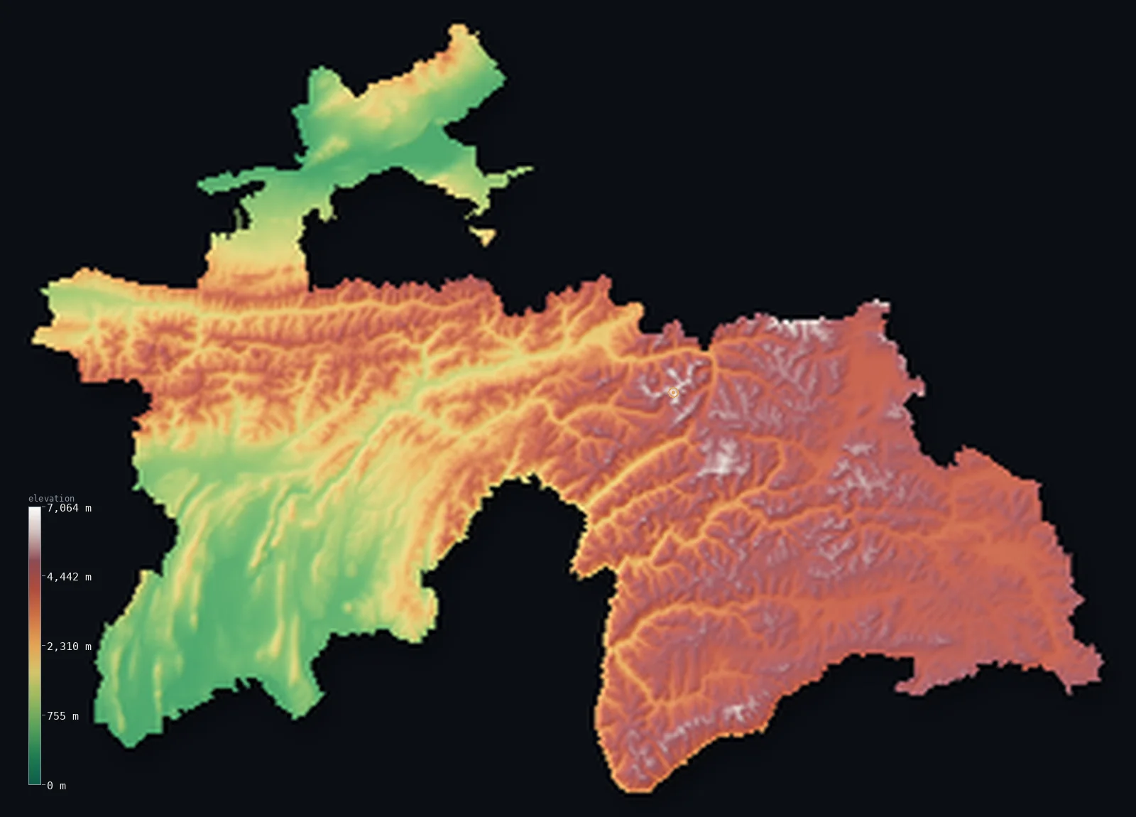
Tajikistan’s highest point is Ismoil Somoni Peak at 24,590 ft (7,495 m); its lowest is Syr Darya at 984 ft (300 m); the mean elevation is 9,688 ft (2,953 m).
Tajikistan is one of the highest countries on Earth. More than nine-tenths of it is mountain, and its terrain is dominated by the Pamirs — the great knot of high ranges that the region calls the 'Roof of the World' — rising in the east to Ismoil Somoni Peak at 24,590 ft (7,495 m). Its mean elevation, about 9,688 ft (2,953 m), is the highest of any country on this map — higher than Nepal or Bhutan. Only in the north and southwest, in the Fergana Valley's edge and the lowland along the rivers, does the land come down; the rest is high mountain, glacier, and plateau.
- Highest point📚
- 24,590 ft7,495 m
- Tajikistan's highest point is Ismoil Somoni Peak at 24,590 ft (7,495 m), in the Pamirs of the east — a colossal glaciated summit, the highest in the country and one of the highest in the former Soviet Union, known in Soviet times as Communism Peak. It rises among a tangle of 7,000-metre peaks and vast glaciers, the high heart of the Pamir 'Roof of the World.' (On the elevation model its ice-covered summit reads about 7,406 m; the surveyed height is 7,495 m.)
- Lowest point📚
- 984 ft300 m
- Tajikistan's lowest point is on the Syr Darya river where it leaves the country in the far north, at about 984 ft (300 m) — in the Fergana Valley's edge, the lowest and one of the few genuinely low corners of an overwhelmingly high country.
- Mean elevation⚙
- 9,688 ft2,953 m
- Computed from the GLO-30 model, Tajikistan's mean elevation is 9,688 ft (2,953 m) — the highest mean of any country on this map, higher than Nepal or Bhutan. It is a true measure of a country that is almost entirely high mountain: the Pamirs and their ranges fill the land, with only narrow river lowlands lying low.
- Median elevation⚙
- 10,883 ft3,317 m
- Half of Tajikistan lies above about 10,883 ft (3,317 m) — an extraordinary median, higher than the summit of most countries: the bulk of the land is genuinely very high mountain and plateau, more than half of it standing above 3,000 m, and only the low river valleys fall away.
- Elevation range📚
- 23,606 ft7,195 m
- From the Syr Darya at 300 m to the summit of Ismoil Somoni Peak at 7,495 m, Tajikistan's terrain climbs more than 23,000 ft — a vast range, but a high one: even the base sits well up, and most of the country lies in the upper reaches of that span, in the high Pamirs.
- Above 1,000 m (3,281 ft)⚙
- 82%
- About 82% of Tajikistan rises above 1,000 m (3,281 ft) — the great bulk of a high-mountain country, though the deep river valleys of the north and southwest bring nearly a fifth of it below that line, the only real breaks in the high ground.
- Above 2,000 m (6,562 ft)⚙
- 68%
- Roughly 68% of Tajikistan stands above 2,000 m (6,562 ft), and more than half of it above 3,000 m — a measure of a country that is high mountain almost throughout, the great mass of the Pamirs and the ranges around them.
- Official area📚
- 55,637 mi²144,100 km²
- Tajikistan covers about 55,600 sq mi (144,100 sq km) — a landlocked country in Central Asia, overwhelmingly mountainous, dominated by the high Pamirs in the east, with lower land only in the northern Fergana edge and the southwestern river valleys.
- Forest cover📚
- 3%
- About 3% of Tajikistan is forested — very little: the high, dry mountains carry alpine meadow, rock, and glacier rather than forest, with some woodland in the lower valleys; most of the country is too high and too arid for trees.
Highest and lowest points
Tajikistan's highest point is Ismoil Somoni Peak, 24,590 ft (7,495 m), in the Pamirs of the eastern part of the country — a vast glaciated pyramid that is the highest point in Tajikistan and was, in the Soviet era, the highest in the entire Soviet Union, when it was called Communism Peak (and before that, Stalin Peak). It rises in the Pamir 'Roof of the World,' surrounded by 7,000-metre peaks and some of the longest glaciers outside the polar regions, including the great Fedchenko Glacier. On the elevation model the ice-covered summit reads about 7,406 m; the surveyed height is 7,495 m, the figure given here. It is the roof of one of the highest countries on this map.
source ↗Tajikistan's lowest point is on the Syr Darya river where it flows out of the country in the far north, at about 984 ft (300 m) above sea level, in the edge of the fertile Fergana Valley. Landlocked and overwhelmingly high, Tajikistan has very little low ground: this northern lowland and the southwestern valleys along the Vakhsh and Panj rivers are the only genuinely low country, and even they sit well above the sea. From them the land rises fast and far into the Pamirs — nowhere on this map does so much of a country stand so high.
source ↗Tajikistan at a glance
Ismoil Somoni Peak (7,495 m) was the highest point in the entire Soviet Union, and has been called Stalin Peak and Communism Peak.
source ↗The Fedchenko Glacier in the Pamirs, about 77 km long, is one of the longest glaciers in the world outside the polar regions.
source ↗Mountains cover about 93 percent of Tajikistan, giving it one of the highest mean elevations of any country.
source ↗The country has three separate peaks above 7,000 m, all in or near the Pamirs.
source ↗The eastern Pamir is a cold high-altitude desert plateau, with the salt lake Karakul lying above 3,900 m.
source ↗
Elevation profile of Tajikistan
The largest share of land, 17%, falls in the 4,000–4,500 m band, and 93% of the territory lies above 500 m (1,640 ft).
- below 500 m (1,640 ft)7%
- 500–1,000 m11%
- 1,000–2,000 m14%
- above 2,000 m (6,562 ft)68%
Highest peaks of Tajikistan
| Peak | Elevation | Range | Note |
|---|---|---|---|
| Ismoil Somoni Peak↗ | 24,590 ft7,495 m | Academy of Sciences Range (Pamirs) | Highest point of Tajikistan and the former Soviet Union, in the western Pamirs. |
| Ibn Sina Peak (Lenin Peak)↗ | 23,406 ft7,134 m | Trans-Alay Range (Pamirs) | The second-highest, on the northern border with Kyrgyzstan. |
| Peak Korzhenevskaya↗ | 23,310 ft7,105 m | Academy of Sciences Range (Pamirs) | A third seven-thousander, just north of Ismoil Somoni Peak. |
| Karl Marx Peak↗ | 22,067 ft6,726 m | Shakhdara Range (Pamirs) | A high peak of the southwestern Pamirs, near the Afghan border. |
| Engels Peak↗ | 21,358 ft6,510 m | Shakhdara Range (Pamirs) | A neighbouring high peak of the southwestern Pamirs. |
Tajikistan: the Pamirs, the western ranges, and the valleys
The Pamirs (the east)
The eastern half of Tajikistan is the Pamirs — a vast, high mountain knot of glaciated peaks, high plateaus, and long glaciers, rising to Ismoil Somoni Peak and holding much of the country's highest ground. Cold, thin-aired, and sparsely peopled, the 'Roof of the World' is the high heart of Tajikistan.
The western and central ranges
West of the Pamirs the mountains continue in a series of high ranges — the Zarafshan, Hisar, and others — running east to west, separated by deep valleys. High and rugged still, though lower than the Pamirs, they fill the centre of the country between the eastern knot and the western lowlands.
The valleys and lowlands
Tajikistan's low ground lies in its valleys — the Fergana Valley's edge in the far north, and the southwestern valleys of the Vakhsh and Panj (upper Amu Darya) — fertile, warmer, and holding most of the population and farming. These river lowlands, though high by other countries' measure, are the country's low, settled country.
How to read this map
Color shows elevation; the raised relief shows real terrain. On this map Tajikistan reads as high country almost throughout — the browns and whites of high mountain filling nearly the whole frame, densest and highest in the great Pamir knot of the east around Ismoil Somoni Peak, with only the thin green threads of the northern Fergana edge and the southwestern river valleys lying low.
The 3D relief is the actual GLO-30 elevation data, exaggerated vertically — though Tajikistan's own relief is so extreme it barely needs it; the ×N relief slider controls how much. Tap anywhere to read that point's exact elevation.
City elevations in Tajikistan
Tajikistan's cities sit in the valleys and lowlands — Dushanbe, the capital, in a western valley; Khujand, Isfara, and Istaravshan in the northern Fergana edge; Bokhtar and Kŭlob in the southwest — while a few, like Khorugh and Ishqoshim, sit remarkably high in the Pamirs of the southeast. Nearly all lie in the lower river country; the high mountains hold few towns.
| City | Population | Elevation |
|---|---|---|
| Dushanbecapitalthe capital, in a western river valley ↗ | 679,400 | 2,526 ft770 m |
| Isfarain the north, in the Fergana Valley's edge ↗ | 274,000 | 2,700 ft823 m |
| Istaravshanin the north, below the Turkestan Range ↗ | 273,500 | 3,205 ft977 m |
| Kŭlobin the southwest, in the lower southern valleys ↗ | 214,700 | 2,011 ft613 m |
| Khujandin the far north, in the Fergana Valley's edge — the country's second city and lowest ↗ | 191,000 | 1,109 ft338 m |
| Bokhtarin the southwest, in the Vakhsh valley ↗ | 110,800 | 1,407 ft429 m |
| Panjakentin the northwest, in the upper Zarafshan valley ↗ | 35,085 | 3,261 ft994 m |
| Zarhalolin the southwestern river lowlands ↗ | 30,689 | 1,358 ft414 m |
| Khorughhigh in the Pamirs of the southeast on the Panj, one of the highest towns in the country ↗ | 30,500 | 6,854 ft2,089 m |
| Ishqoshimin the far southeast on the Panj (the Afghan border), among the highest settlements, deep in the Pamirs ↗ | 26,000 | 8,317 ft2,535 m |
Elevation sampled at each city centre from the Copernicus GLO-30 model. Cities and population from GeoNames (CC-BY 4.0).
Tajikistan in comparison
Tajikistan's terrain rises 23,606 ft (7,195 m) from Syr Darya (984 ft (300 m)) to Ismoil Somoni Peak — about 81% of the height of Mount Everest, the world's highest point at 29,032 ft (8,849 m).
- Kyrgyzstan's mean elevation is 8,655 ft — 1,033 ft lower; its high point, Jengish Chokusu (Victory Peak), reaches 24,406 ft (7,439 m), 184 ft below. Kyrgyzstan elevation map →
- Afghanistan's mean elevation is 5,906 ft — 3,783 ft lower; its high point, Noshaq, reaches 24,580 ft (7,492 m), 10 ft below. Afghanistan elevation map →
- Uzbekistan's mean elevation is 1,171 ft — 8,517 ft lower; its high point, Peak 4,643m (Gissar Range), reaches 15,233 ft (4,643 m), 9,357 ft below. Uzbekistan elevation map →
Frequently asked questions
What is the highest point in Tajikistan?
- Ismoil Somoni Peak, 24,590 ft (7,495 m), in the Pamirs — the highest in the country and once the highest in the whole Soviet Union (Communism Peak). Its glaciated summit reads about 7,406 m on the elevation model.
What is the lowest point in Tajikistan?
- On the Syr Darya river in the far north, at about 984 ft (300 m), in the Fergana Valley's edge — the lowest corner of an overwhelmingly high country.
What is the average elevation of Tajikistan?
- About 9,688 ft (2,953 m), computed from the Copernicus GLO-30 model — the highest mean elevation of any country on this map, higher than Nepal or Bhutan, because Tajikistan is almost entirely high Pamir mountain.
Is Tajikistan the highest country in the world?
- By mean elevation it is the highest on this map (9,688 ft (2,953 m), above Nepal and Bhutan), and more than half of it lies above 3,000 m. Its highest peak, Ismoil Somoni, reaches 7,495 m in the Pamirs.
What are the Pamirs?
- A great knot of high mountains in eastern Tajikistan and beyond, called the 'Roof of the World' — glaciated peaks, high plateaus, and long glaciers, holding the country's highest ground including Ismoil Somoni Peak.
Is this a topographic, relief, contour, or elevation map of Tajikistan?
- They describe the same thing — terrain height. This page renders the country's actual elevation surface in interactive 3D and reports the statistics computed from it.
About this map
The terrain is rendered from the Copernicus GLO-30 digital elevation model (ESA), masked to the TJK-ADM0 boundary from geoBoundaries (gbOpen). Elevation statistics are computed directly from the model; peak names and researched facts are sourced and cited. See the methodology for the full pipeline.
Our area-weighted mean, computed from the Copernicus GLO-30 model, is 9,688 ft (2,953 m); the figure commonly cited elsewhere is 10,453 ft (3,186 m) (CIA World Factbook). More than nine-tenths of Tajikistan is high Pamir mountain, so its area-weighted mean is the highest of any country on this map. The figure computed here from the Copernicus GLO-30 model is about 2,953 m; the CIA World Factbook cites a higher 3,186 m, likely from a different sampling of the high peaks and glaciers.
Surveyed national figures: official area · forest cover · high point.
Rendered from Copernicus GLO-30 (ESA, 2021 release), boundaries from geoBoundaries. Generated 2026-07-07.
Bordering countries · 4
Tajikistan shares a land border with these countries — open any one to compare its terrain and highest point.