Uzbekistan Elevation Map — Topographic & 3D Terrain
Explore the terrain of Uzbekistan in interactive 3D, built from Copernicus GLO-30 satellite elevation data — desert and steppe plains rising to mountains along the southeastern edge. Drag to rotate, scroll to zoom, and tap any point to read its elevation.
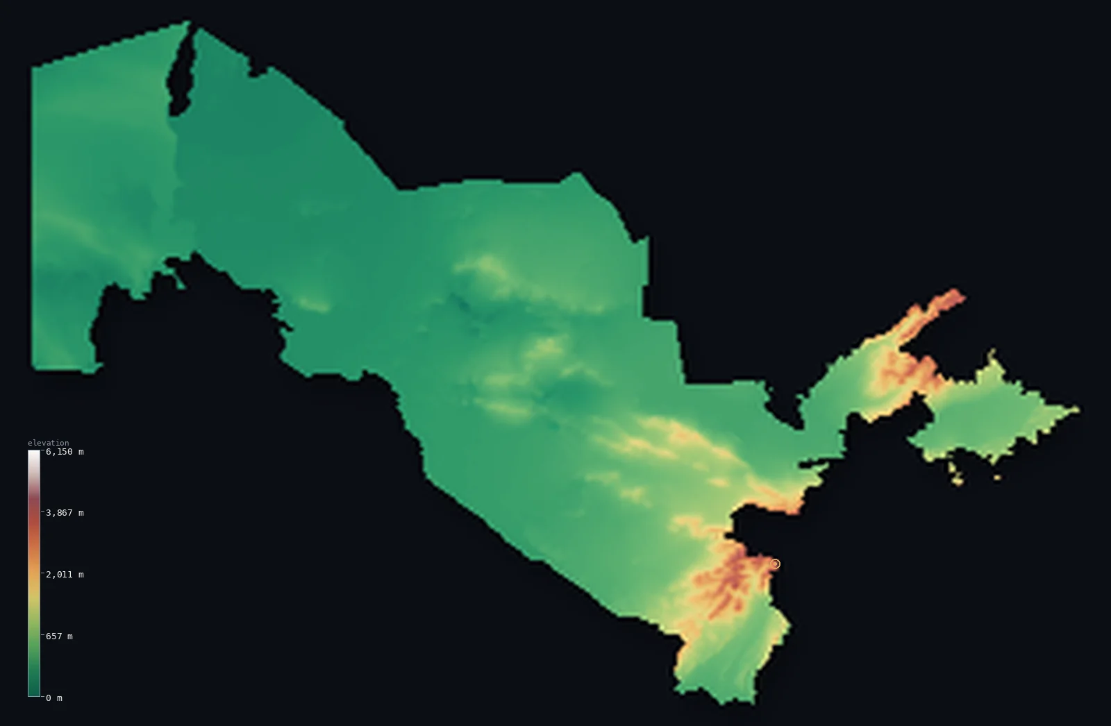
Uzbekistan’s highest point is Peak 4,643m (Gissar Range) at 15,233 ft (4,643 m); its lowest is Sariqamish Kuli at −39 ft (−12 m); the mean elevation is 1,171 ft (357 m).
Uzbekistan is mostly flat and mostly dry — the Kyzylkum desert and the plains of the Amu Darya and Syr Darya fill the west and centre, and about half the country lies below 656 ft (200 m). The mountains come only at the southeastern edge, where the western spurs of the Tian Shan and the Gissar range rise toward Tajikistan, carrying the country's high point to 15,233 ft (4,643 m). In the far northwest, the bed of the vanished Aral Sea has become a new desert of salt.
- Highest point📚
- 15,233 ft4,643 m
- Uzbekistan's highest point is a 15,233 ft (4,643 m) summit in the Gissar Range, on the border with Tajikistan in the southeast — the crest of the western spurs of the Pamir-Alay system, where Uzbekistan's plains finally give way to real mountains. (A 2023 survey identified a neighbouring frontier peak that may be slightly higher; the mapped high point here is the long-established summit.)
- Lowest point📚
- −39 ft−12 m
- Uzbekistan's lowest point is the Sariqamish Depression at about 39 ft (12 m) below sea level, on the northwestern border with Turkmenistan — a lake basin fed by the shifting tail of the Amu Darya, one of several below-sea hollows in the deserts of Central Asia.
- Mean elevation⚙
- 1,171 ft357 m
- Computed from the GLO-30 model, Uzbekistan's mean elevation is 1,171 ft (357 m) — but the average hides the shape of the country, which is overwhelmingly low desert and steppe plain with all its height concentrated in a single southeastern corner.
- Median elevation⚙
- 646 ft197 m
- Half of Uzbekistan lies below 646 ft (197 m) — well under the mean, and the clearest statement of the country's form: the great majority is low plain, the Kyzylkum and the river valleys, with the Gissar mountains lifting only a narrow eastern fraction.
- Elevation range📚
- 15,272 ft4,655 m
- From the Sariqamish Depression below sea level to the Gissar summit, Uzbekistan spans about 15,270 ft — a wide range for a country that is mostly flat, with nearly all of it gained in the mountainous southeastern sliver.
- Above 1,000 m (3,281 ft)⚙
- 7%
- About 7% of Uzbekistan rises above 1,000 m (3,281 ft) — the Gissar and Chatkal ranges of the southeast, the fertile valleys of the Fergana approaches and the mountain fringe. The other nine-tenths is desert and plain.
- Above 2,000 m (6,562 ft)⚙
- 3%
- Roughly 3% of Uzbekistan stands above 2,000 m (6,562 ft) — the higher ground of the southeastern ranges alone, a small mountainous margin on an otherwise low country.
- Official area📚
- 172,742 mi²447,400 km²
- Uzbekistan covers about 172,700 sq mi (447,400 sq km) — a doubly-landlocked country (one of only two on Earth), stretching from the Aral basin across the Kyzylkum to the mountains of the southeast.
- Forest cover📚
- 8.5%
- About 8.5% of Uzbekistan is forested — a small share, as befits a desert country; what woodland there is clings to the mountain slopes and the riverbanks, not the Kyzylkum.
Highest and lowest points
Uzbekistan's highest point is a 15,233 ft (4,643 m) summit in the Gissar Range, on the Tajikistan border in the southeast — part of the western Pamir-Alay, where the mountains of Central Asia begin. It is the high corner of a low country: from here the land falls away northwest across hundreds of kilometres of plain and desert to the Aral basin. A 2023 survey reported a neighbouring border peak a few metres higher; the established summit is the one mapped here, and the two stand close together on the frontier.
source ↗Uzbekistan's lowest point is the Sariqamish Depression, about 39 ft (12 m) below sea level, a lake basin straddling the northwestern border with Turkmenistan. It is fed by the Amu Darya when the river's flow reaches it — a shifting, salty terminal lake in the desert. It is a different and lower feature than the Aral basin to its north, and marks the deepest ground in the country.
source ↗Peak 4,643m (Gissar Range) is a border summit: its peak lies just outside the generalized Uzbekistan boundary, so the highest fully in-territory land pixel in the model is 14,780 ft (4,505 m). The headline figure above is the surveyed elevation of the recognised national high point.
Uzbekistan at a glance
Uzbekistan is one of only two doubly-landlocked countries on Earth — surrounded entirely by landlocked neighbours — the other being Liechtenstein.
source ↗About 60% of Uzbekistan is desert or semi-desert, dominated by the Kyzylkum, one of the largest deserts in Central Asia.
source ↗The Aral Sea, once one of the largest lakes in the world, has largely dried since the 1960s; its former bed in northwestern Uzbekistan is now the Aralkum, a desert of salt and sand.
source ↗All of Uzbekistan's high ground is packed into its southeastern corner, where the western spurs of the Tian Shan and the Gissar range rise toward Tajikistan.
source ↗The Amu Darya and Syr Darya, Central Asia's two great rivers, cross Uzbekistan on their way to what remains of the Aral basin, watering the oases that sustain most of the population.
source ↗A 2023 survey found a neighbouring border peak, Alpomish (~4,668 m), to be slightly higher than the long-accepted summit.
source ↗
Elevation profile of Uzbekistan
The largest share of land, 83%, falls in the 0–500 m band, and 83% of the territory lies below 500 m (1,640 ft).
- below 500 m (1,640 ft)83%
- 500–1,000 m10%
- 1,000–2,000 m4%
- above 2,000 m (6,562 ft)3%
Highest peaks of Uzbekistan
| Peak | Elevation | Range | Note |
|---|---|---|---|
| Peak 4,643m (Gissar Range)↗ | 15,233 ft4,643 m | Gissar (Hisar) Range | Long-recognised highest point of Uzbekistan, on the Tajik border; the nearby Alpomish (~4,668 m) was found slightly higher in 2023. |
| Adelunga Toghi↗ | 14,111 ft4,301 m | Pskem Range (Tien Shan) | The highest peak of the Pskem Range in the northeast, in the western Tien Shan. |
| Beshtor↗ | 14,104 ft4,299 m | Pskem Range (Tien Shan) | The second-highest peak of the Pskem Range, just below Adelunga in the northeast. |
The Kyzylkum, the river oases, and the mountain corner
The Kyzylkum and the western plains
Most of Uzbekistan is the Kyzylkum — the 'red sand' desert filling the centre and northwest — and the low plains around it. Flat, dry, and sparsely peopled, it is the bulk of the country's area and the reason its elevation figures are so low.
The Amu Darya, Syr Darya, and the oases
Uzbekistan's life follows its two great rivers and the canals drawn from them — the Amu Darya along the southern and western borders, the Syr Darya in the northeast — watering the oasis cities of Bukhara, Samarkand, and the Fergana approaches in an otherwise arid land.
The Aral basin and the Aralkum
In the far northwest lies the basin of the Aral Sea, once a vast lake, now largely a salt desert — the Aralkum — where the water has retreated. It is among the most dramatic human alterations of any landscape on Earth, and it renders here as dry ground, not water.
The southeastern mountains
Along the southeastern border with Tajikistan and Kyrgyzstan the land finally rises — the Gissar, Chatkal, and Kurama ranges, western spurs of the Tian Shan and Pamir-Alay, carrying the country's high point and framing the fertile Fergana Valley beyond.
How to read this map
Color shows elevation; the raised relief shows real terrain. On this map Uzbekistan reads as a broad low expanse of desert and plain in greens and pale browns, with the dry Aral basin at the northwest and a knot of high brown-and-white mountains gathered in the southeastern corner.
The 3D relief is the actual GLO-30 elevation data, exaggerated vertically so the low plains and the mountain corner both show; the ×N relief slider controls how much. Tap anywhere to read that point's exact elevation.
City elevations in Uzbekistan
Uzbekistan's cities sit on the plains and in the oases — Tashkent in the east near the mountains, Samarkand and Bukhara on the historic Silk Road oases, the others along the rivers. Few stand much above the surrounding plain.
| City | Population | Elevation |
|---|---|---|
| Tashkentcapitalthe capital, in the east near the foothills of the Tian Shan, the largest city in Central Asia ↗ | 1,978,028 | 1,401 ft427 m |
| Andijon | 747,800 | 1,627 ft496 m |
| Samarkanda Silk Road oasis city on the Zerafshan valley ↗ | 595,200 | 2,359 ft719 m |
| Nukus | 332,500 | 253 ft77 m |
| Bukhara | 280,187 | 751 ft229 m |
| Qarshi | 278,300 | 1,260 ft384 m |
| Qo‘qon | 259,700 | 1,345 ft410 m |
| Tirmiz | 182,800 | 1,001 ft305 m |
| Urganch | 145,000 | 328 ft100 m |
| Bekobod | 96,900 | 994 ft303 m |
Elevation sampled at each city centre from the Copernicus GLO-30 model. Cities and population from GeoNames (CC-BY 4.0).
Uzbekistan in comparison
Uzbekistan's terrain rises 15,272 ft (4,655 m) from Sariqamish Kuli, 39 ft (12 m) below sea level to Peak 4,643m (Gissar Range) — about 53% of the height of Mount Everest, the world's highest point at 29,032 ft (8,849 m).
- Tajikistan's mean elevation is 9,688 ft — 8,517 ft higher; its high point, Ismoil Somoni Peak, reaches 24,590 ft (7,495 m), 9,357 ft above. Tajikistan elevation map →
- Turkmenistan's mean elevation is 650 ft — 522 ft lower; its high point, Ayrybaba (Gora Ayribaba), reaches 10,299 ft (3,139 m), 4,934 ft below. Turkmenistan elevation map →
- Kyrgyzstan's mean elevation is 8,655 ft — 7,484 ft higher; its high point, Jengish Chokusu (Victory Peak), reaches 24,406 ft (7,439 m), 9,173 ft above. Kyrgyzstan elevation map →
Frequently asked questions
What is the highest point in Uzbekistan?
- A 4,643 m (15,233 ft) summit in the Gissar Range on the Tajik border — the high corner of an otherwise low country. A 2023 survey identified a neighbouring frontier peak that may be slightly higher.
What is the lowest point in Uzbekistan?
- The Sariqamish Depression, about 12 m (39 ft) below sea level, a salty terminal lake basin on the northwestern border.
What is the average elevation of Uzbekistan?
- Computed from the Copernicus GLO-30 model, the area-weighted mean is 1,171 ft (357 m) — though the country is overwhelmingly low desert and plain, with its height confined to the southeastern mountains.
Is Uzbekistan flat?
- Mostly — about 60% is desert or steppe below 200 m. Its mountains are confined to the southeastern corner, where the Tian Shan and Gissar ranges rise toward Tajikistan.
What happened to the Aral Sea?
- Once one of the largest lakes in the world, it has largely dried since the 1960s as its rivers were diverted for irrigation; its bed in northwestern Uzbekistan is now the Aralkum salt desert, and renders on this map as dry land.
Is this a topographic, relief, contour, or elevation map of Uzbekistan?
- They describe the same thing — terrain height. This page renders the country's actual elevation surface in interactive 3D and reports the statistics computed from it.
About this map
The terrain is rendered from the Copernicus GLO-30 digital elevation model (ESA), masked to the UZB-ADM0 boundary from geoBoundaries (gbOpen). Elevation statistics are computed directly from the model; peak names and researched facts are sourced and cited. See the methodology for the full pipeline.
Our area-weighted mean, computed from the Copernicus GLO-30 model, is 1,171 ft (357 m); no authority publishes a mean elevation (No single authoritative mean elevation). No standard source gives a single mean elevation for Uzbekistan; the country is mostly low desert - the Kyzylkum and the dried Aral basin - with mountains only in the east and southeast, so the mean is low. The page reports the area-weighted figure computed from the Copernicus GLO-30 model.
Surveyed national figures: official area · forest cover · high point.
Rendered from Copernicus GLO-30 (ESA, 2021 release), boundaries from geoBoundaries. Generated 2026-07-08.
Bordering countries · 5
Uzbekistan shares a land border with these countries — open any one to compare its terrain and highest point.