Turkmenistan Elevation Map — Topographic & 3D Terrain
Explore the terrain of Turkmenistan in interactive 3D, built from Copernicus GLO-30 satellite elevation data — one great desert, ringed by low mountains and sunk below sea level in its hollows. Drag to rotate, scroll to zoom, and tap any point to read its elevation.
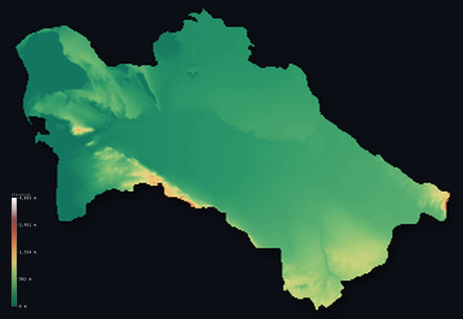
Turkmenistan’s highest point is Ayrybaba (Gora Ayribaba) at 10,299 ft (3,139 m); its lowest is Akjagaya Depression at −266 ft (−81 m); the mean elevation is 650 ft (198 m).
Turkmenistan is desert almost all the way through — the Karakum, the 'black sand,' covers around 80% of the country, a vast low expanse of dune and takyr. It is one of the flattest countries in Asia, with a median elevation of just 502 ft (153 m), and it dips well below sea level in its desert hollows: the Akjagaýa Depression lies 266 ft (81 m) down, and more than 8% of the whole country sits beneath the level of the sea. The only real height is at the edges — the Kopet Dag along the Iranian border, and the Köýtendag in the far east, where Aýrybaba reaches 10,299 ft (3,139 m).
- Highest point📚
- 10,299 ft3,139 m
- Turkmenistan's highest point is Aýrybaba at 10,299 ft (3,139 m), in the Köýtendag range on the far eastern border with Uzbekistan — an isolated limestone massif rising abruptly from the desert, the single piece of high mountain in an overwhelmingly low country.
- Lowest point📚
- −266 ft−81 m
- Turkmenistan's lowest point is the Akjagaýa Depression at about 266 ft (81 m) below sea level, a deep desert hollow in the north — one of many below-sea basins that make Turkmenistan one of the lowest-lying countries in Asia, with more than 8% of its land beneath sea level.
- Mean elevation⚙
- 650 ft198 m
- Computed from the GLO-30 model, Turkmenistan's mean elevation is 650 ft (198 m) — very low, as befits a country that is around four-fifths desert: the Karakum sand fills the centre, and only the mountain rims at the country's edges rise above it.
- Median elevation⚙
- 502 ft153 m
- Half of Turkmenistan lies below 502 ft (153 m) — one of the lowest median elevations of any country in Asia, the signature of the Karakum, a single enormous desert of low sand and clay covering the great bulk of the land.
- Elevation range📚
- 10,564 ft3,220 m
- From the floor of the Akjagaýa Depression to the summit of Aýrybaba, Turkmenistan spans about 10,560 ft — but the range is misleading: almost the entire country is low desert near sea level, and both the deep hollows and the one high massif are exceptions at its margins.
- Above 1,000 m (3,281 ft)⚙
- 1%
- Only about 1% of Turkmenistan rises above 1,000 m (3,281 ft) — essentially just the Köýtendag massif in the far east and the crest of the Kopet Dag along the Iranian border. The country is otherwise one of the flattest in Asia.
- Official area📚
- 188,456 mi²488,100 km²
- Turkmenistan covers about 188,500 sq mi (488,100 sq km) — most of it the Karakum desert, bordered by the Caspian Sea to the west and ringed by low mountains along its southern and eastern edges.
- Forest cover📚
- 8.8%
- About 8.8% of Turkmenistan is forested — very little, in a country four-fifths desert; the sparse woodland is confined to the mountain slopes of the Kopet Dag and Köýtendag, not the Karakum sands.
Highest and lowest points
Turkmenistan's highest point is Aýrybaba, 10,299 ft (3,139 m), in the Köýtendag range on the far eastern border with Uzbekistan. It is a limestone massif — riddled with caves, including some of the largest in Central Asia — rising sharply from the surrounding desert plain. It is the only true mountain height in the country: the Kopet Dag along the Iranian border is lower, and everything between is the low sand of the Karakum. The summit is shared with Uzbekistan, though it is not that country's high point.
source ↗Turkmenistan's lowest point is the Akjagaýa Depression, about 266 ft (81 m) below sea level, a deep hollow in the northern Karakum. It is one of a series of below-sea desert basins that make Turkmenistan remarkable: more than 8% of the entire country lies beneath sea level, a far larger share than almost anywhere else. These are dry, salt-floored depressions, not flooded ones — the land itself sits below the sea without the sea reaching it. The Caspian shore in the west is also below sea level, at about −28 m, but as an inland endorheic sea, not an ocean coast.
source ↗Turkmenistan at a glance
The Karakum desert — the 'black sand' — covers around 80% of Turkmenistan, making it one of the most desert-dominated countries on Earth.
source ↗More than 8% of Turkmenistan lies below sea level, in dry desert depressions like the Akjagaýa — among the largest below-sea shares of any country.
source ↗Turkmenistan's highest point, Aýrybaba (3,139 m), is a limestone massif in the Köýtendag riddled with some of the largest caves in Central Asia.
source ↗The Köýtendag range holds a plateau covered with hundreds of preserved Jurassic dinosaur footprints.
source ↗The Kopet Dag mountains run along Turkmenistan's entire southern border with Iran, a long but relatively low range separating the Karakum from the Iranian plateau.
source ↗Turkmenistan's western edge meets the Caspian Sea, whose surface lies about 28 m below sea level — an inland endorheic sea, so the country's Caspian 'coast' is itself below the level of the ocean.
source ↗
Elevation profile of Turkmenistan
The largest share of land, 59%, falls in the 0–200 m band, and 92% of the territory lies below 500 m (1,640 ft).
- below 500 m (1,640 ft)92%
- 500–1,000 m7%
- 1,000–2,000 m1%
- above 2,000 m (6,562 ft)<1%
Highest peaks of Turkmenistan
| Peak | Elevation | Range | Note |
|---|---|---|---|
| Ayrybaba (Gora Ayribaba)↗ | 10,299 ft3,139 m | Koytendag (Kugitang) Range | Highest point of Turkmenistan, on the Uzbek border in the far southeast. |
| Mount Sahshah (Rizeh)↗ | 9,554 ft2,912 m | Kopet Dag | The highest point of the Kopet Dag range within Turkmenistan, southwest of Ashgabat on the Iranian border. |
The Karakum and the mountains at the rim
The Karakum desert
The overwhelming fact of Turkmenistan — the 'black sand' desert filling around 80% of the country, a vast low plain of dune, salt flat, and takyr clay. It holds the country's below-sea depressions, its sparse population strung along canals, and its statistical bulk: this is why Turkmenistan is so low and so flat.
The Kopet Dag and the southern border
Along the entire southern frontier with Iran runs the Kopet Dag, a long, relatively low mountain range that walls the Karakum off from the Iranian plateau. The capital, Ashgabat, sits at its foot, in the narrow inhabited strip between the mountains and the sand.
The Köýtendag and the eastern edge
In the far east, on the border with Uzbekistan, the Köýtendag range rises to Aýrybaba, the country's high point — an isolated limestone massif of caves and canyons, abrupt and singular against the desert. The Amu Darya runs along the country's eastern and northern edge nearby.
How to read this map
Color shows elevation; the raised relief shows real terrain. On this map Turkmenistan reads as one enormous low desert in pale greens and browns, dipping to darker below-sea hollows in the north, with low mountain rims along the southern border and a single high massif at the far eastern corner.
The 3D relief is the actual GLO-30 elevation data, exaggerated vertically so the desert's faint undulations, the deep depressions, and the edge mountains all show; the ×N relief slider controls how much. Tap anywhere to read that point's exact elevation.
City elevations in Turkmenistan
Turkmenistan's cities cluster where there is water — Ashgabat at the foot of the Kopet Dag in the south, the others along the Amu Darya and the Karakum Canal. The desert interior is nearly empty.
| City | Population | Elevation |
|---|---|---|
| Ashgabatcapitalthe capital, at the foot of the Kopet Dag near the Iranian border, in the strip between mountains and desert ↗ | 1,030,063 | 725 ft221 m |
| Türkmenabat | 230,861 | 630 ft192 m |
| Daşoguz | 201,142 | 285 ft87 m |
| Mary | 167,027 | 738 ft225 m |
| Türkmenbaşy | 91,745 | 20 ft6 m |
| Balkanabat | 87,822 | 26 ft8 m |
| Tejen | 67,488 | 617 ft188 m |
| Gyzylarbat | 48,558 | 338 ft103 m |
| Magdanly | 44,508 | 1,411 ft430 m |
| Bäherden | 37,588 | 528 ft161 m |
Elevation sampled at each city centre from the Copernicus GLO-30 model. Cities and population from GeoNames (CC-BY 4.0).
Turkmenistan in comparison
Turkmenistan's terrain rises 10,564 ft (3,220 m) from Akjagaya Depression, 266 ft (81 m) below sea level to Ayrybaba (Gora Ayribaba) — about 36% of the height of Mount Everest, the world's highest point at 29,032 ft (8,849 m).
- Uzbekistan's mean elevation is 1,171 ft — 522 ft higher; its high point, Peak 4,643m (Gissar Range), reaches 15,233 ft (4,643 m), 4,934 ft above. Uzbekistan elevation map →
- Iran's mean elevation is 4,101 ft — 3,451 ft higher; its high point, Mount Damavand, reaches 18,406 ft (5,610 m), 8,107 ft above. Iran elevation map →
- Afghanistan's mean elevation is 5,906 ft — 5,256 ft higher; its high point, Noshaq, reaches 24,580 ft (7,492 m), 14,281 ft above. Afghanistan elevation map →
Frequently asked questions
What is the highest point in Turkmenistan?
- Aýrybaba, 10,299 ft (3,139 m), a limestone massif in the Köýtendag range on the eastern border with Uzbekistan — the country's only true mountain height.
What is the lowest point in Turkmenistan?
- The Akjagaýa Depression, about 266 ft (81 m) below sea level — one of many below-sea desert hollows; more than 8% of the country lies beneath sea level.
What is the average elevation of Turkmenistan?
- Computed from the Copernicus GLO-30 model, the area-weighted mean is 650 ft (198 m) — very low, because around 80% of the country is the Karakum desert.
Is Turkmenistan below sea level?
- In large part, remarkably — more than 8% of the country sits beneath sea level in dry desert depressions like the Akjagaýa, and its Caspian shore is below sea level too, as the Caspian is an inland endorheic sea.
How much of Turkmenistan is desert?
- Around 80% — the Karakum, one of the largest sand deserts in Asia, which fills the centre of the country and gives it one of the lowest median elevations on the continent.
Is this a topographic, relief, contour, or elevation map of Turkmenistan?
- They describe the same thing — terrain height. This page renders the country's actual elevation surface in interactive 3D and reports the statistics computed from it.
About this map
The terrain is rendered from the Copernicus GLO-30 digital elevation model (ESA), masked to the TKM-ADM0 boundary from geoBoundaries (gbOpen). Elevation statistics are computed directly from the model; peak names and researched facts are sourced and cited. See the methodology for the full pipeline.
Our area-weighted mean, computed from the Copernicus GLO-30 model, is 650 ft (198 m); no authority publishes a mean elevation (No single authoritative mean elevation (sources cite roughly 100-220 m)). Sources give Turkmenistan's average elevation as a range of about 100-220 m rather than one figure, since roughly 80 percent of the country is the low Karakum desert and the Turan Depression. The page reports the area-weighted mean computed from the Copernicus GLO-30 model.
Surveyed national figures: official area · forest cover · high point.
Rendered from Copernicus GLO-30 (ESA, 2021 release), boundaries from geoBoundaries. Generated 2026-07-08.
Bordering countries · 4
Turkmenistan shares a land border with these countries — open any one to compare its terrain and highest point.