Kazakhstan Elevation Map — Topographic & 3D Terrain
Explore the terrain of Kazakhstan in interactive 3D, built from Copernicus GLO-30 satellite elevation data — a vast open steppe with all its high ground packed into one corner. Drag to rotate, scroll to zoom, and tap any point to read its elevation.
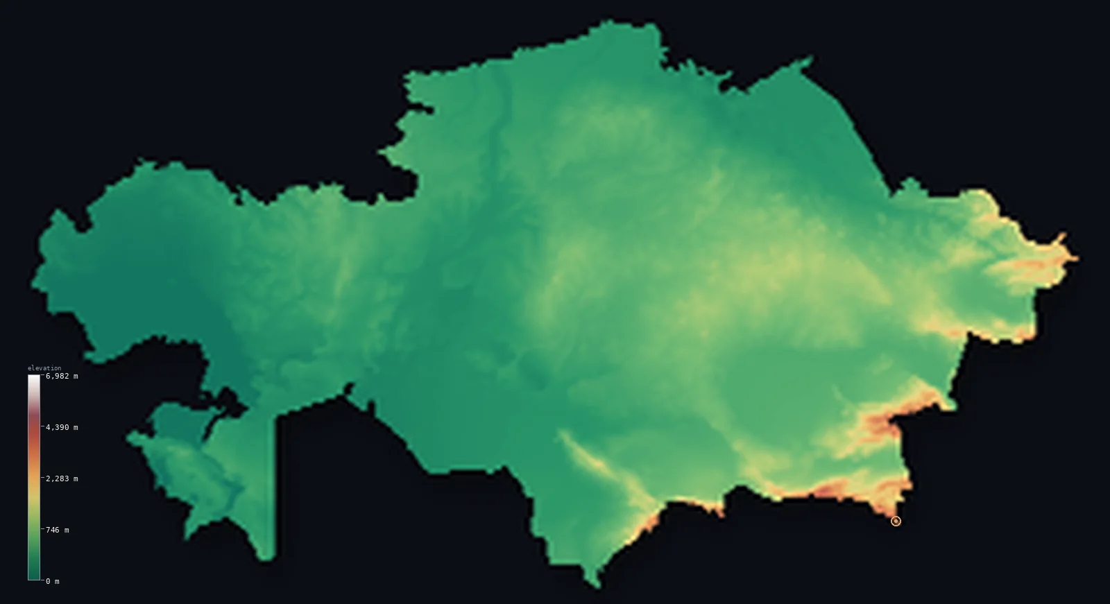
Kazakhstan’s highest point is Khan Tengri at 22,999 ft (7,010 m); its lowest is Karagiye Depression (Vpadina Kaundy) at −433 ft (−132 m); the mean elevation is 1,178 ft (359 m).
Kazakhstan is enormous, flat, and almost entirely steppe — about 79% of it lies below 1,640 ft (500 m), rolling grassland and semi-desert running for thousands of kilometres without meaningful relief. And then, in one southeastern corner, the ground erupts: Khan Tengri reaches 22,999 ft (7,010 m) at the point where Kazakhstan, Kyrgyzstan and China meet — the most northerly 7,000-metre peak on Earth. Almost nothing else in the country comes close.
- Highest point📚
- 22,999 ft7,010 m
- Kazakhstan's highest point is Khan Tengri at 22,999 ft (7,010 m), a marble pyramid at the tripoint with Kyrgyzstan and China — the most northerly mountain on Earth to exceed 7,000 m. That figure includes its ice cap; the rock summit beneath stands at 6,995 m, which is why some sources list it just under the 7,000-metre line.
- Lowest point📚
- −433 ft−132 m
- Kazakhstan's lowest point is the Karagiye Depression at 433 ft (132 m) below sea level — a deep, dry hollow on the Mangyshlak Peninsula east of the Caspian, formed as underground limestone dissolved and the surface collapsed into it.
- Mean elevation⚙
- 1,178 ft359 m
- Kazakhstan's mean elevation computed from the GLO-30 model is 1,178 ft (359 m) — low for the world's largest landlocked country, because the overwhelming majority of it is steppe and desert plain, with the high ground confined to a single southeastern corner.
- Median elevation⚙
- 837 ft255 m
- Half of Kazakhstan lies below 837 ft (255 m) — roughly a hundred metres beneath the mean, a gap opened almost entirely by the high southeastern corner: the Tian Shan's extreme summits pull the average upward, while the typical Kazakh plain sits lower still.
- Elevation range📚
- 23,432 ft7,142 m
- From the floor of the Karagiye Depression to the summit of Khan Tengri, Kazakhstan spans more than 23,400 ft — one of the widest ranges of any country, and remarkable in a place where you can drive for a full day across the steppe without the land changing height by 100 m.
- Above 1,000 m (3,281 ft)⚙
- 5%
- Only about 5% of Kazakhstan rises above 1,000 m (3,281 ft) — the Tian Shan and Altai ranges along the southeastern and eastern borders. The rest of the country is plain, steppe, and desert.
- Above 2,000 m (6,562 ft)⚙
- 1%
- Roughly 1% of Kazakhstan stands above 2,000 m (6,562 ft) — effectively all of it in the Tian Shan and Altai along the southeastern and eastern borders, the country's only genuine mountain country.
- Official area📚
- 1,052,089 mi²2,724,900 km²
- Kazakhstan covers about 1,050,000 sq mi (2,724,900 sq km) — the largest landlocked country on Earth, stretching from the Caspian to the Chinese border across a distance greater than the width of Europe.
- Forest cover📚
- 1.2%
- About 1.2% of Kazakhstan is forested — a small share, and almost none of it on the open steppe: what woodland exists clings to the northern forest-steppe fringe and the mountain slopes of the southeast.
Highest and lowest points
Kazakhstan's highest point is Khan Tengri, 22,999 ft (7,010 m), standing at the tripoint where Kazakhstan, Kyrgyzstan and China meet in the Tian Shan — the most northerly peak on Earth above 7,000 m, and a mountain famous for turning blood-red at sunset, its marble flanks catching the last light. Its height carries a caveat: 7,010 m is the elevation with the summit ice cap included, while the rock beneath tops out at 6,995 m, so some sources place it just below the 7,000-metre threshold.
source ↗Kazakhstan's lowest point is the Karagiye Depression, 433 ft (132 m) below sea level, on the Mangyshlak Peninsula east of the Caspian Sea. It is a karst hollow — the ground collapsed over centuries as water dissolved the limestone beneath it — and it is dry, salt-floored, and far from any shoreline. That makes it a different kind of low point from the Caspian coast itself, which lies about 28 m below sea level: Karagiye is an inland pit, more than a hundred metres deeper than the sea beside it.
source ↗Khan Tengri is a border summit: its peak lies just outside the generalized Kazakhstan boundary, so the highest fully in-territory land pixel in the model is 22,907 ft (6,982 m). The headline figure above is the surveyed elevation of the recognised national high point.
Kazakhstan at a glance
Khan Tengri, at the Kazakhstan-Kyrgyzstan-China tripoint, is the most northerly mountain on Earth to exceed 7,000 m.
source ↗Khan Tengri's height is given as both 7,010 m and 6,995 m - the higher figure includes its summit ice cap, the lower is the rock beneath.
source ↗About 79% of Kazakhstan lies below 500 m - steppe, semi-desert and plain covering nearly the whole country.
source ↗Kazakhstan's lowest point, the Karagiye Depression at 132 m below sea level, is a dry karst hollow more than a hundred metres deeper than the nearby Caspian Sea.
source ↗Kazakhstan is the largest landlocked country in the world, stretching from the Caspian to the Chinese border.
source ↗Kazakhstan borders two shrinking inland seas - the Caspian and the Aral.
source ↗Kazakhstan is the ninth-largest country in the world by total area.
source ↗
Elevation profile of Kazakhstan
The largest share of land, 74%, falls in the 0–500 m band, and 79% of the territory lies below 500 m (1,640 ft).
- below 500 m (1,640 ft)79%
- 500–1,000 m16%
- 1,000–2,000 m3%
- above 2,000 m (6,562 ft)1%
Highest peaks of Kazakhstan
| Peak | Elevation | Range | Note |
|---|---|---|---|
| Khan Tengri↗ | 22,999 ft7,010 m | Tian Shan | Highest point of Kazakhstan, a tripoint summit with Kyrgyzstan and China; icecap 7,010 m, rock 6,995 m. |
| Peak Talgar↗ | 16,335 ft4,979 m | Trans-Ili Alatau (Tian Shan) | The highest summit of the Trans-Ili Alatau above Almaty, entirely within Kazakhstan. |
| Mount Belukha↗ | 14,783 ft4,506 m | Altai | The highest peak of the Altai and of northern Kazakhstan, on the Russian border in the far east. |
An immense plain, with the mountains in one corner
The steppe
The defining Kazakh landscape — a belt of open grassland and semi-desert running the full width of the country, flat to gently rolling, treeless, and vast. It covers the great majority of Kazakhstan's area and is the reason its elevation figures are so uniformly low.
The Caspian lowlands and Karagiye
In the west the land falls toward the Caspian Sea, whose surface sits below sea level, and the Mangyshlak Peninsula beyond it holds the Karagiye Depression — a dry karst hollow 132 m down, the country's lowest ground.
The central uplands and deserts
Across the middle of the country the steppe is broken by the low worn hills of the Kazakh Uplands and, to the south, by the sands of the Betpak-Dala and Kyzylkum deserts — dry country that lifts the land only slightly.
The Tian Shan and Altai (southeast and east)
All of Kazakhstan's real height is packed against its southeastern and eastern borders, where the Tian Shan carries Khan Tengri at the Chinese and Kyrgyz frontier and the Altai rises in the east. It is a narrow rim on an enormous country.
How to read this map
Color shows elevation; the raised relief shows real terrain. On this map Kazakhstan reads as an immense, almost featureless plain in low greens and browns, with a sudden knot of white and dark brown at the southeastern corner where the Tian Shan rises.
The 3D relief is the actual GLO-30 elevation data, exaggerated vertically so the steppe's faint undulations and the mountain corner both show; the ×N relief slider controls how much. Tap anywhere to read that point's exact elevation.
City elevations in Kazakhstan
Kazakh cities sit on the plain almost without exception - Astana out on the open northern steppe, the western cities near the Caspian. Only Almaty, the former capital, stands noticeably higher, on the alluvial fans at the foot of the Tian Shan.
| City | Population | Elevation |
|---|---|---|
| Almatyat the foot of the Tian Shan in the southeast, the highest of the major cities ↗ | 1,977,011 | 2,598 ft792 m |
| Astanacapitalthe capital, on the open northern steppe ↗ | 1,544,142 | 1,178 ft359 m |
| Shymkent | 1,200,000 | 1,673 ft510 m |
| Aktobe | 500,757 | 696 ft212 m |
| Karagandy | 497,777 | 1,788 ft545 m |
| Taraz | 358,153 | 2,067 ft630 m |
| Kyzylorda | 354,800 | 423 ft129 m |
| Oral | 330,000 | 121 ft37 m |
| Pavlodar | 329,002 | 433 ft132 m |
| Ust-Kamenogorsk | 319,067 | 945 ft288 m |
Elevation sampled at each city centre from the Copernicus GLO-30 model. Cities and population from GeoNames (CC-BY 4.0).
Kazakhstan in comparison
Kazakhstan's terrain rises 23,432 ft (7,142 m) from Karagiye Depression (Vpadina Kaundy), 433 ft (132 m) below sea level to Khan Tengri — about 81% of the height of Mount Everest, the world's highest point at 29,032 ft (8,849 m).
- Uzbekistan's mean elevation is 1,171 ft — 7 ft lower; its high point, Peak 4,643m (Gissar Range), reaches 15,233 ft (4,643 m), 7,766 ft below. Uzbekistan elevation map →
- Turkmenistan's mean elevation is 650 ft — 528 ft lower; its high point, Ayrybaba (Gora Ayribaba), reaches 10,299 ft (3,139 m), 12,700 ft below. Turkmenistan elevation map →
- Kyrgyzstan's mean elevation is 8,655 ft — 7,477 ft higher; its high point, Jengish Chokusu (Victory Peak), reaches 24,406 ft (7,439 m), 1,407 ft above. Kyrgyzstan elevation map →
Frequently asked questions
What is the highest point in Kazakhstan?
- Khan Tengri, 22,999 ft (7,010 m), at the tripoint with Kyrgyzstan and China - the most northerly 7,000-metre peak on Earth. The figure includes its ice cap; the rock summit is 6,995 m.
What is the lowest point in Kazakhstan?
- The Karagiye Depression, 433 ft (132 m) below sea level - a dry karst hollow east of the Caspian.
What is the average elevation of Kazakhstan?
- Computed from the Copernicus GLO-30 model, the area-weighted mean is 1,178 ft (359 m) - low, because steppe and desert plain cover the great majority of the country.
Is Kazakhstan flat?
- Overwhelmingly - about 79% lies below 500 m. Its mountains are confined to the southeastern and eastern borders, where the Tian Shan and Altai rise.
Why are there two heights given for Khan Tengri?
- 7,010 m includes the summit's ice cap; 6,995 m is the rock beneath it - which is why some sources list the mountain just under 7,000 m.
Is this a topographic, relief, contour, or elevation map of Kazakhstan?
- They describe the same thing - terrain height. This page renders the country's actual elevation surface in interactive 3D and reports the statistics computed from it.
About this map
The terrain is rendered from the Copernicus GLO-30 digital elevation model (ESA), masked to the KAZ-ADM0 boundary from geoBoundaries (gbOpen). Elevation statistics are computed directly from the model; peak names and researched facts are sourced and cited. See the methodology for the full pipeline.
Because Kazakhstan covers 2,706,655 km², its 3D terrain surface is rendered at roughly 1.6 km per pixel rather than the model’s native 30 m — the full-resolution grid exceeds the render budget for an area this large. The high point and every elevation figure on this page are still measured at native 30 m resolution; only the rendered surface detail is coarsened.
Our area-weighted mean, computed from the Copernicus GLO-30 model, is 1,178 ft (359 m); no authority publishes a mean elevation (No authoritative published mean elevation). No standard source publishes a single mean elevation for Kazakhstan, a huge country of low steppe and desert with high mountains only along its southern and eastern rim. The page reports the area-weighted figure computed from the Copernicus GLO-30 model, shown at reduced surface resolution for a country this large.
Surveyed national figures: official area · forest cover · high point.
Rendered from Copernicus GLO-30 (ESA, 2021 release), boundaries from geoBoundaries. Generated 2026-07-12.
Bordering countries · 5
Kazakhstan shares a land border with these countries — open any one to compare its terrain and highest point.