Kyrgyzstan Elevation Map — Topographic & 3D Terrain
Explore the terrain of Kyrgyzstan in interactive 3D, built from Copernicus GLO-30 satellite elevation data — a high mountain country of the Tien Shan, with the great lake Issyk-Kul at its heart. Drag to rotate, scroll to zoom, and tap any point to read its elevation.
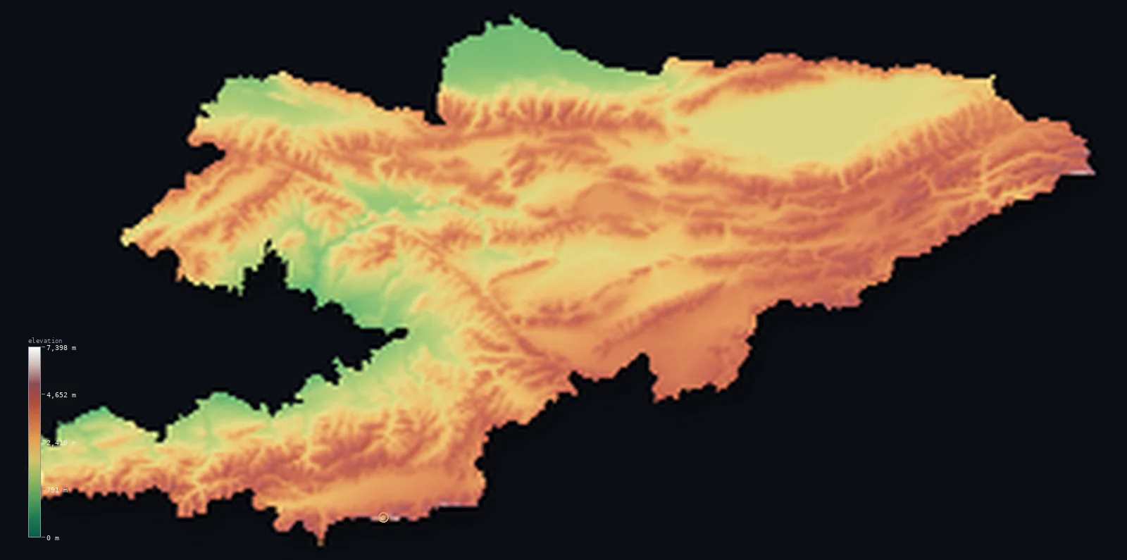
Kyrgyzstan’s highest point is Jengish Chokusu (Victory Peak) at 24,406 ft (7,439 m); its lowest is Kara-Darya valley (Fergana) at 433 ft (132 m); the mean elevation is 8,655 ft (2,638 m).
Kyrgyzstan is a high country of the Tien Shan. Mountains cover almost all of it — the great ranges of the Tien Shan, the 'Celestial Mountains,' filling the land and rising in the east to Jengish Chokusu (Pik Pobedy) at 24,406 ft (7,439 m) on the Chinese border. Its mean elevation is among the highest of any country on Earth. Set high among the ranges is Issyk-Kul, one of the world's largest and deepest mountain lakes; and in the southwest, the country reaches down into a corner of the fertile Fergana Valley — the main break in an overwhelmingly high, mountainous land.
- Highest point📚
- 24,406 ft7,439 m
- Kyrgyzstan's highest point is Jengish Chokusu — Pik Pobedy, 'Victory Peak' — at 24,406 ft (7,439 m), on the border with China in the eastern Tien Shan. It is the highest peak of the Tien Shan and the northernmost 7,000-metre summit on Earth, a colossal glaciated mountain among the highest ground in Central Asia. (On the elevation model its ice-covered summit reads about 7,398 m; the surveyed height is 7,439 m.)
- Lowest point📚
- 433 ft132 m
- Kyrgyzstan's lowest point is in the southwest, where the Kara-Darya river leaves the country in the Fergana Valley, at about 433 ft (132 m) — the lowest and most fertile corner of a country that is otherwise overwhelmingly high mountain.
- Mean elevation⚙
- 8,655 ft2,638 m
- Computed from the GLO-30 model, Kyrgyzstan's mean elevation is 8,655 ft (2,638 m) — among the highest of any country on this map. The Tien Shan holds the whole country up; its settled valleys already lie high, and only the Fergana corner drops to genuine lowland.
- Median elevation⚙
- 8,940 ft2,725 m
- Half of Kyrgyzstan lies above about 8,940 ft (2,725 m) — a very high median, marking a genuinely high-mountain country: fully half its area stands above 2,700 m, in Tien Shan range or high valley, with the low Fergana corner and the river valleys the exceptions.
- Elevation range📚
- 23,973 ft7,307 m
- Kyrgyzstan's relief spans more than 23,000 ft in all, from the low Fergana edge at 132 m to Jengish Chokusu at 7,439 m — but that low corner is the rare exception: half the country stands above 2,725 m, so the great climb begins from ground that is already high.
- Above 1,000 m (3,281 ft)⚙
- 94%
- About 94% of Kyrgyzstan rises above 1,000 m (3,281 ft) — nearly the whole country: even the valley floors mostly stand above that line, and only the low Fergana corner in the southwest drops beneath it.
- Above 2,000 m (6,562 ft)⚙
- 70%
- Roughly 70% of Kyrgyzstan stands above 2,000 m (6,562 ft), much of it above 3,000 m — the great mass of the Tien Shan ranges that fill the country, high, glaciated, and snow-capped.
- Official area📚
- 77,201 mi²199,951 km²
- Kyrgyzstan covers about 77,200 sq mi (199,951 sq km) — a landlocked country in Central Asia, overwhelmingly mountainous, filled by the ranges of the Tien Shan, with the great lake Issyk-Kul in the northeast and a corner of the Fergana Valley in the southwest.
- Forest cover📚
- 5.1%
- About 5% of Kyrgyzstan is forested — not much: the high mountains carry alpine meadow, rock, and glacier, though the country holds some unusual woodlands, including the vast walnut forests of Arslanbob in the southwest; most of the land is too high for forest.
Highest and lowest points
Kyrgyzstan's highest point is Jengish Chokusu — Pik Pobedy, 'Victory Peak' — at 24,406 ft (7,439 m), on the Chinese border in the eastern Tien Shan. It is the highest peak of the whole Tien Shan range and the northernmost 7,000-metre mountain in the world, a huge glaciated summit notorious among climbers for its cold and its storms. It stands near Khan Tengri, another great peak, in a high glaciated corner of the country. On the elevation model its ice-covered summit reads about 7,398 m; the surveyed height is 7,439 m, the figure given here. It is the roof of one of the highest countries on this map.
source ↗Kyrgyzstan's lowest point is in the far southwest, where the Kara-Darya river flows out of the country into the Fergana Valley, at about 433 ft (132 m) above sea level. This corner of the fertile Fergana Valley — the great lowland shared between Kyrgyzstan, Uzbekistan, and Tajikistan — is the country's lowest, warmest, and most densely farmed ground. From it the land rises fast into the Tien Shan: Kyrgyzstan is overwhelmingly high, and even its valley floors mostly lie well above the sea.
source ↗Kyrgyzstan at a glance
Jengish Chokusu (7,439 m) is the most northerly 7,000 m peak on Earth and the highest point of the entire Tian Shan, which stretches some 2,500 km across Central Asia.
source ↗Almost 90% of Kyrgyzstan lies above 1,500 m, and more than half of it above 2,500 m - one of the most mountainous countries on Earth.
source ↗Kyrgyzstan has about 6,500 glaciers holding hundreds of cubic kilometres of fresh water, making it a vital 'water tower' for Central Asia.
source ↗Lake Issyk-Kul, in the northeastern mountains, is one of the world's largest mountain lakes and is so deep and saline it never freezes.
source ↗Khan Tengri's rock summit is 6,995 m, but its permanent ice cap pushes its height to about 7,010 m - so climbers count it as a 7,000 m peak.
source ↗Three of the five highest mountains of the former Soviet Union - Jengish Chokusu, Lenin Peak and Khan Tengri - rise in or on the borders of Kyrgyzstan.
source ↗
Elevation profile of Kyrgyzstan
The largest share of land, 19%, falls in the 3,000–3,500 m band, and >99% of the territory lies above 500 m (1,640 ft).
- below 500 m (1,640 ft)<1%
- 500–1,000 m6%
- 1,000–2,000 m24%
- above 2,000 m (6,562 ft)70%
Highest peaks of Kyrgyzstan
| Peak | Elevation | Range | Note |
|---|---|---|---|
| Jengish Chokusu (Victory Peak)↗ | 24,406 ft7,439 m | Kakshaal-Too (China border, east) | Highest point of Kyrgyzstan and of the whole Tian Shan, and the most northerly 7,000 m peak on Earth. |
| Lenin Peak↗ | 23,406 ft7,134 m | Trans-Alay (Tajikistan border, southwest) | On the Tajik border in the Trans-Alay, rising above the Alay Valley - one of the most-climbed 7,000 m peaks. |
| Khan Tengri↗ | 22,999 ft7,010 m | Tian Shan (northeast tripoint) | A striking marble pyramid near the Kazakhstan-China tripoint; 6,995 m of rock plus an ice cap reaching ~7,010 m. |
| Chapaev Peak↗ | 20,902 ft6,371 m | Tengri Tag (east) | A high peak of the Tengri Tag, on the ridge near Khan Tengri above the Engilchek Glacier. |
| Karakol Peak↗ | 17,326 ft5,281 m | Terskey Ala-Too (near Issyk-Kul, northeast) | A prominent peak of the Terskey Ala-Too south of Lake Issyk-Kul, above the town of Karakol. |
Kyrgyzstan: the Tien Shan, Issyk-Kul, and the Fergana edge
The Tien Shan ranges
Almost all of Kyrgyzstan is the Tien Shan — the 'Celestial Mountains,' a great system of high, glaciated ranges filling the country, rising highest in the east to Jengish Chokusu on the Chinese border. Snow-capped, deeply glaciated, and cut by high valleys, they are the mountainous body of the country.
Issyk-Kul and the northeastern basin
In the northeast, ringed by the Tien Shan, lies Issyk-Kul — one of the world's largest and deepest mountain lakes, a vast blue lake set high among the peaks that never freezes despite the altitude. Its basin is a distinct, milder pocket in the high country, drawing settlement to the lakeshore.
The Fergana edge and the valleys
In the southwest Kyrgyzstan reaches down into a corner of the Fergana Valley — the fertile lowland shared with its neighbours — and its river valleys, the Chuy in the north and others, provide the country's lower, farmed, settled ground. These lowlands, low by Kyrgyz measure, hold much of the population.
How to read this map
Color shows elevation; the raised relief shows real terrain. On this map Kyrgyzstan reads as high mountain almost throughout — browns and whites of the Tien Shan ranges filling the frame, highest and most glaciated in the east around Jengish Chokusu on the Chinese border, with the great blue oval of Issyk-Kul set among the northeastern peaks and the low green of the Fergana corner in the southwest.
The 3D relief is the actual GLO-30 elevation data, exaggerated vertically — though the Tien Shan is dramatic enough that it hardly needs the exaggeration; the ×N relief slider controls how much. Tap anywhere to read that point's exact elevation.
City elevations in Kyrgyzstan
Kyrgyzstan's cities sit in the valleys and basins — Bishkek, the capital, in the northern Chuy Valley; Osh, Batken, and the others in the southwestern Fergana edge; Karakol and Balykchy on Issyk-Kul; Naryn high in the central Tien Shan. Nearly all lie in the lower valley country; the high ranges hold few towns.
| City | Population | Elevation |
|---|---|---|
| Bishkekcapitalthe capital, in the northern Chuy Valley ↗ | 900,000 | 2,516 ft767 m |
| Oshin the southwest, in the Fergana Valley's edge — the country's second city ↗ | 322,164 | 3,232 ft985 m |
| Quvasoy | 96,900 | 2,671 ft814 m |
| Karakolnear the eastern end of Issyk-Kul, below the high Tien Shan ↗ | 84,351 | 5,755 ft1,754 m |
| Balykchyat the western end of Issyk-Kul ↗ | 42,875 | 5,384 ft1,641 m |
| Narynhigh in the central Tien Shan on the Naryn river, one of the highest towns ↗ | 41,178 | 6,736 ft2,053 m |
| Talasin the northwest, in the Talas valley ↗ | 40,308 | 4,058 ft1,237 m |
| Uchqŭrghon Shahri | 40,000 | 1,621 ft494 m |
| Razzakovin the far southwest, in the Batken region near the Tajik border ↗ | 34,219 | 4,281 ft1,305 m |
| Batkenin the far southwest, in the Fergana edge ↗ | 27,730 | 3,402 ft1,037 m |
Elevation sampled at each city centre from the Copernicus GLO-30 model. Cities and population from GeoNames (CC-BY 4.0).
Kyrgyzstan in comparison
Kyrgyzstan's terrain rises 23,973 ft (7,307 m) from Kara-Darya valley (Fergana) (433 ft (132 m)) to Jengish Chokusu (Victory Peak) — about 83% of the height of Mount Everest, the world's highest point at 29,032 ft (8,849 m).
- Tajikistan's mean elevation is 9,688 ft — 1,033 ft higher; its high point, Ismoil Somoni Peak, reaches 24,590 ft (7,495 m), 184 ft above. Tajikistan elevation map →
- Kazakhstan's mean elevation is 1,178 ft — 7,477 ft lower; its high point, Khan Tengri, reaches 22,999 ft (7,010 m), 1,407 ft below. Kazakhstan elevation map →
- Uzbekistan's mean elevation is 1,171 ft — 7,484 ft lower; its high point, Peak 4,643m (Gissar Range), reaches 15,233 ft (4,643 m), 9,173 ft below. Uzbekistan elevation map →
Frequently asked questions
What is the highest point in Kyrgyzstan?
- Jengish Chokusu (Pik Pobedy, Victory Peak), 24,406 ft (7,439 m), on the Chinese border — the highest peak of the Tien Shan and the northernmost 7,000-metre summit on Earth. Its glaciated summit reads about 7,398 m on the elevation model.
What is the lowest point in Kyrgyzstan?
- In the far southwest, where the Kara-Darya leaves the country in the Fergana Valley, at about 433 ft (132 m) — the lowest, most fertile corner of a high country.
What is the average elevation of Kyrgyzstan?
- Computed from the Copernicus GLO-30 model, the area-weighted mean is 8,655 ft (2,638 m) — among the highest of any country on this map, because Kyrgyzstan is almost entirely Tien Shan mountain, with only the Fergana corner and the valleys low.
What is Issyk-Kul?
- One of the world's largest and deepest mountain lakes, set high among the Tien Shan in northeastern Kyrgyzstan — a vast, slightly saline lake that never freezes despite the altitude, ringed by high peaks.
How mountainous is Kyrgyzstan?
- Almost entirely — the Tien Shan ranges fill the country, most of it lies above 2,000 m and much above 3,000 m, with the highest peak, Jengish Chokusu, reaching 7,439 m. Only the Fergana corner and the valleys are low.
Is this a topographic, relief, contour, or elevation map of Kyrgyzstan?
- They describe the same thing — terrain height. This page renders the country's actual elevation surface in interactive 3D and reports the statistics computed from it.
About this map
The terrain is rendered from the Copernicus GLO-30 digital elevation model (ESA), masked to the KGZ-ADM0 boundary from geoBoundaries (gbOpen). Elevation statistics are computed directly from the model; peak names and researched facts are sourced and cited. See the methodology for the full pipeline.
Our area-weighted mean, computed from the Copernicus GLO-30 model, is 8,655 ft (2,638 m); the figure commonly cited elsewhere is 9,022 ft (2,750 m) (CIA World Factbook). Almost all of Kyrgyzstan is Tien Shan mountain, so its area-weighted mean is among the highest of any country on this map. The figure computed here from the Copernicus GLO-30 model is about 2,638 m; the CIA World Factbook cites 2,750 m.
Surveyed national figures: official area · forest cover · high point.
Rendered from Copernicus GLO-30 (ESA, 2021 release), boundaries from geoBoundaries. Generated 2026-06-23.
Bordering countries · 4
Kyrgyzstan shares a land border with these countries — open any one to compare its terrain and highest point.