Asia Elevation Map
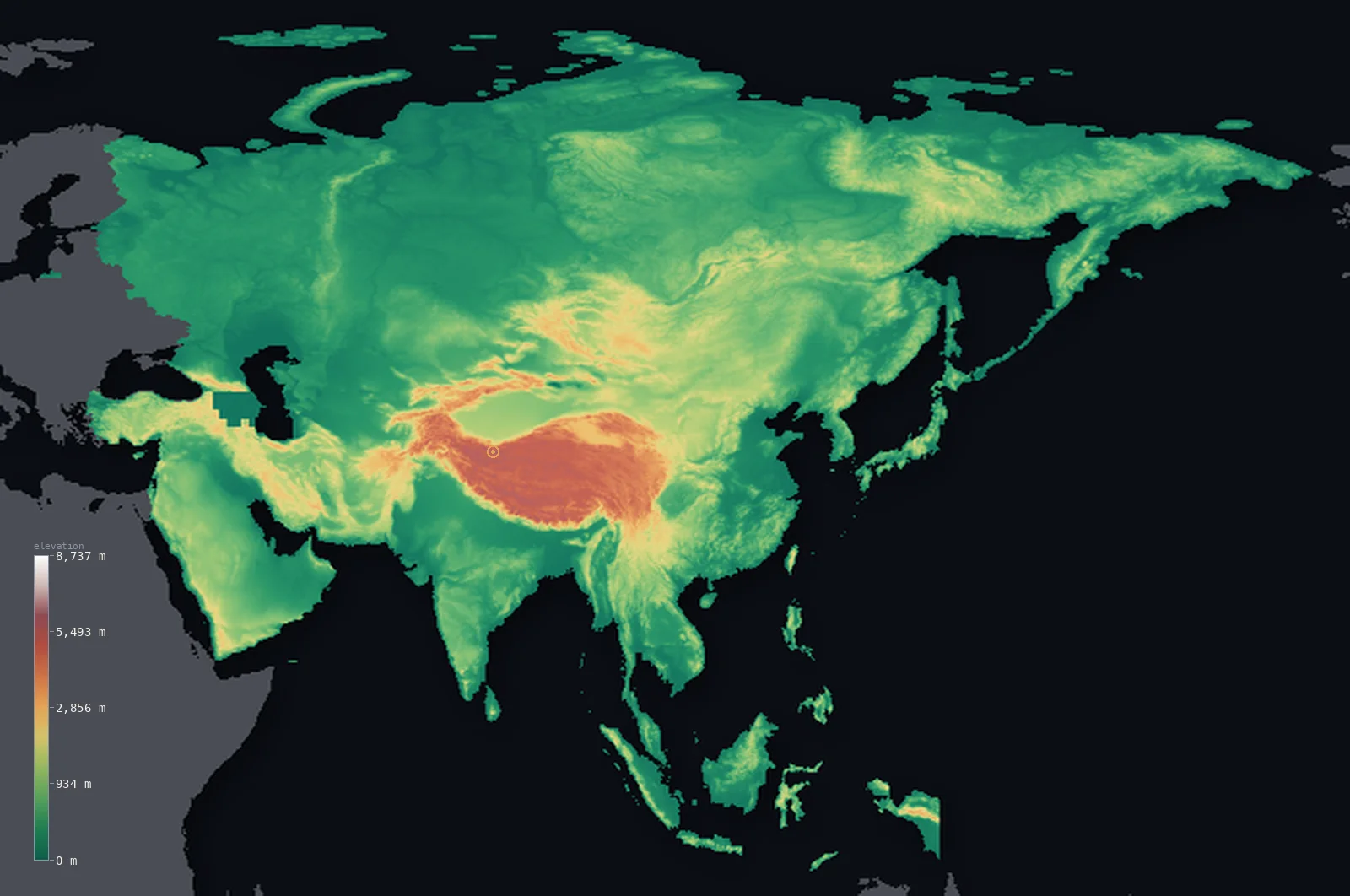
Asia’s highest point is Mount Everest at 29,032 ft (8,849 m); its lowest is Dead Sea shore at −1,444 ft (−440 m); the mean elevation is 2,631 ft (802 m).
- Highest point📚
- 29,032 ft8,849 m
- Asia's highest point is Mount Everest at 29,032 ft (8,849 m), on the border of Nepal and China in the Himalaya - the highest point not just in Asia but on the entire surface of the Earth. It crowns the great mountain wall of the Himalaya, where the Indian subcontinent drives into Asia and throws up the highest mountains on the planet - a cluster of peaks over 8,000 m, of which Everest is the summit. No land anywhere rises higher.
- Lowest point📚
- −1,444 ft−440 m
- Asia's lowest point - and the lowest dry land anywhere on the surface of the Earth - is the shore of the Dead Sea, at about 1,444 ft (440 m) below sea level, on the border of Israel and Jordan. It lies in the deepest part of the great rift valley that runs from the Levant into East Africa, a hypersaline lake whose surface drops lower year by year. So Asia holds both extremes of the Earth's land surface: the highest point and the lowest.
- Mean elevation⚙
- 2,631 ft802 m
- Computed from the GLO-30 model, Asia's mean elevation is 2,631 ft (802 m) - the second-highest of any continent (after Antarctica), lifted by the great high mass at its heart: the Himalaya, the Tibetan Plateau, and the high ranges of Central Asia. But this height is concentrated, not general - half of Asia lies below about 1,243 ft (379 m). The vast lowlands of Siberia, the plains of India and China, and the deserts of Arabia and Central Asia are the broad body of the continent; the great highlands, though the highest on Earth, are an area-minority that lifts the average far above the typical point.
- Median elevation⚙
- 1,243 ft379 m
- Half of Asia lies below about 1,243 ft (379 m) - far below the mean, because Asia, despite holding the highest mountains on Earth, is for the most part not high. The Himalaya and the Tibetan Plateau form a great high mass, but it is a minority of the area; most of the continent is lowland - the Siberian plains, the basins of India and China, the Arabian and Central Asian deserts. The high heart lifts the average; the low majority sets the midpoint far beneath it.
- Elevation range📚
- 30,476 ft9,289 m
- From the Dead Sea shore at 440 m below sea level to the summit of Mount Everest at 8,849 m, Asia spans about 30,476 ft - the greatest elevation range of any continent, holding both the highest point and the lowest dry land on the surface of the Earth.
- Above 1,000 m (3,281 ft)⚙
- 25%
- About 25% of Asia rises above 1,000 m (3,281 ft) - chiefly the great highland heart: the Tibetan Plateau, the Himalaya and the neighbouring ranges, the mountains of Central Asia, the Iranian and Anatolian plateaus. The vast lowlands - Siberia, the Indian and Chinese plains, the deserts - lie below.
- Above 2,000 m (6,562 ft)⚙
- 10%
- Roughly 10% of Asia stands above 2,000 m (6,562 ft) - above all the Tibetan Plateau, the largest and highest plateau on Earth, together with the high ranges that wall it and the mountains of Central and Southwest Asia. The high roof of the continent, and of the world.
- Official area📚
- 17,220,149 mi²44,600,000 km²
- Asia is the largest continent, covering about 17,220,149 sq mi (44,600,000 sq km) - from the Arctic coast of Siberia to the tropical islands of the south, and from the Mediterranean and Arabian edges in the west to the Pacific in the east. Its heart is the great highland mass of the Himalaya and the Tibetan Plateau (holding Mount Everest), rimmed by the vast lowlands of Siberia, the plains of India and China, and the deserts of Arabia and Central Asia, dropping to the Dead Sea, the lowest dry land on Earth.
- Forest cover📚
- 20%
- About 20% of Asia is forested - from the vast boreal taiga of Siberia (one of the largest forests on Earth), through the temperate forests of the east, to the tropical rainforests of Southeast Asia and the islands, with great arid expanses of desert and steppe across the center and southwest, and alpine desert on the high Tibetan Plateau.
Asia at a glance
Asia contains all fourteen of the world's mountains over 8,000 m, every one in the Himalaya or Karakoram.
source ↗It holds both the highest point on Earth (Everest) and the lowest exposed land (the Dead Sea shore).
source ↗The Tibetan Plateau is so large and high it is nicknamed the 'Third Pole' for its store of ice.
source ↗The West Siberian Plain is one of the largest continuous areas of flat land anywhere on Earth.
source ↗Much of Central Asia drains internally, its rivers ending in closed seas and deserts rather than the ocean.
source ↗
Elevation profile of Asia
The largest share of land, 56%, falls in the 0–500 m band, and 57% of the territory lies below 500 m (1,640 ft).
- below 500 m (1,640 ft)57%
- 500–1,000 m18%
- 1,000–2,000 m15%
- above 2,000 m (6,562 ft)10%
Highest and lowest points
The highest point of Asia - and of the entire Earth - is Mount Everest, 8,849 m, on the Nepal-China border in the Himalayas. Asia holds all fourteen of the world's peaks above 8,000 m, every one of them in the Himalaya and Karakoram.
source ↗Highest peaks of Asia
| Peak | Elevation | Range | Note |
|---|---|---|---|
| Mount Everest↗ | 29,032 ft8,849 m | Himalayas | Highest point of Asia and of Earth, on the Nepal-China border. |
| K2↗ | 28,251 ft8,611 m | Karakoram | The second-highest mountain on Earth, on the China-Pakistan border. |
| Kangchenjunga↗ | 28,169 ft8,586 m | Himalayas | The third-highest mountain on Earth, on the India-Nepal border. |
| Ismoil Somoni Peak↗ | 24,590 ft7,495 m | Pamir | The highest peak of the Pamir mountains, in Tajikistan. |
| Mount Elbrus↗ | 18,510 ft5,642 m | Caucasus | The highest peak of the Caucasus; on this map, shown with Asia as part of Russia. |
Terrain regions of Asia
Asia contains all fourteen of the world's mountains over 8,000 m, every one in the Himalaya or Karakoram. ↗
The high heart of Asia
↗The Himalaya, Karakoram, Pamir, Tian Shan and Kunlun mountains ringing the vast Tibetan Plateau - the highest and most massive highland on Earth.
The northern and central expanses
↗The Siberian plains and plateaus of the north and the deserts and steppes of Central Asia - the Gobi, Taklamakan and Kazakh steppe.
The southern peninsulas and the west
↗The great peninsulas of the south - Arabia, India and Indochina - and the plateaus and rift valleys of the southwest, holding the Dead Sea.
The high heart of Asia
the centre-southThe centre of the continent is the highest land on Earth. The Tibetan Plateau, averaging about 4,000 m, is walled by the planet's greatest mountain ranges - the Himalaya along its south, carrying Everest and all fourteen of the world's 8,000 m peaks, the Karakoram with K2 to the west, and the Pamir, Tian Shan and Kunlun around its edges. From this roof the great rivers of Asia - the Indus, Ganges, Brahmaputra, Yangtze, Mekong and Yellow - all descend.
The northern plains and central deserts
the north and centreNorth of the great mountains stretch the immense lowlands of Siberia - the West Siberian Plain, one of the largest flat areas on Earth, and the Central Siberian Plateau - reaching to the Arctic. To their south lie the arid basins of Central Asia: the Gobi and Taklamakan deserts, the Tarim and Junggar basins, and the wide Kazakh steppe, much of it enclosed and draining to no ocean.
The southern peninsulas and southwest
the south and southwestAsia's south breaks into great peninsulas - the Arabian Peninsula, the Indian subcontinent behind its Himalayan wall, and the mountainous peninsulas of Southeast Asia - fringed by island arcs. In the southwest, the Anatolian and Iranian plateaus give way to the Arabian platform and the Jordan Rift Valley, where the Dead Sea shore, at about 440 m below sea level, is the lowest exposed land on the planet.
City elevations in Asia
| City | Population | Elevation |
|---|---|---|
| Shanghai | 24,874,500 | 16 ft5 m |
| Beijingcapital | 18,960,744 | 154 ft47 m |
| Shenzhen | 17,494,398 | 33 ft10 m |
| Istanbul | 15,701,602 | 112 ft34 m |
| Ho Chi Minh City | 14,002,598 | 23 ft7 m |
| Chengdu | 13,568,357 | 1,640 ft500 m |
| Lahore | 13,004,135 | 722 ft220 m |
| Mumbai | 12,691,836 | 26 ft8 m |
| Karachi | 11,624,219 | 30 ft9 m |
| Delhi | 11,034,555 | 748 ft228 m |
Elevation sampled at each city centre from the Copernicus GLO-30 model. Cities and population from GeoNames (CC-BY 4.0).
Asia in comparison
Asia's terrain rises 30,476 ft (9,289 m) — from Dead Sea shore, 1,444 ft (440 m) below sea level to the summit of Mount Everest itself, the highest point on Earth.
- World's mean elevation is 2,628 ft — 3 ft lower; its high point, Mount Everest, reaches 29,032 ft (8,849 m), 0 ft above. World elevation map →
- Europe's mean elevation is 1,161 ft — 1,470 ft lower; its high point, Mont Blanc, reaches 15,781 ft (4,810 m), 13,251 ft below. Europe elevation map →
- Africa's mean elevation is 2,054 ft — 577 ft lower; its high point, Mount Kilimanjaro, reaches 19,341 ft (5,895 m), 9,692 ft below. Africa elevation map →
Frequently asked questions
What is the highest point in Asia?
- Mount Everest, 29,032 ft (8,849 m), on the Nepal-China border in the Himalaya - the highest point on Earth.
What is the lowest point in Asia?
- The shore of the Dead Sea, about 1,444 ft (440 m) below sea level (Israel/Jordan) - the lowest dry land on Earth.
Does Asia have the highest and lowest points on Earth?
- Yes - Asia holds both extremes of the Earth's land surface: Mount Everest (8,849 m), the highest point, and the shore of the Dead Sea (about 440 m below sea level), the lowest dry land.
What is the average elevation of Asia?
- Computed from the GLO-30 model, about 2,631 ft (802 m) - the second-highest of any continent, though half of Asia lies below about 1,243 ft (379 m), since the great Himalayan-Tibetan highlands are a minority of the area.
Why are Russia and Turkey shown with Asia?
- They straddle Europe and Asia; this map groups each country into the continent holding most of its land, so both appear with Asia.
Where are Asia's highest mountains?
- In the great central knot - the Himalaya (Everest, Kangchenjunga), the Karakoram (K2) and the Pamir - all around the Tibetan Plateau.
Is this a topographic, relief, contour, or elevation map of Asia?
- They describe the same thing - terrain height. This page renders Asia's actual elevation surface in interactive 3D (a relief or topographic view) and reports the statistics computed from it; a contour map shows the same data as lines of equal height.
About this map
The terrain is rendered from the Copernicus GLO-30 digital elevation model (ESA), masked to the CONTINENT-ASIA boundary from geoBoundaries (gbOpen). Elevation statistics are computed directly from the model; peak names and researched facts are sourced and cited. See the methodology for the full pipeline.
This map renders 48,994,611 km² across 9761 landmasses of Asia. 5087 smaller outlying parts — 287,775 km² in total — lie beyond the area shown here. Area statistics above count the full territory.
Because Asia covers 48,994,611 km², its 3D terrain surface is rendered at roughly 7.4 km per pixel rather than the model’s native 30 m — the full-resolution grid exceeds the render budget for an area this large. The high point and every elevation figure on this page are still measured at native 30 m resolution; only the rendered surface detail is coarsened.
Our area-weighted mean, computed from the Copernicus GLO-30 model, is 2,631 ft (802 m); no authority publishes a mean elevation (no single authoritative continental mean). Asia is a continent of extremes. It holds the highest point on Earth - Mount Everest, 8,849 m, in the Himalaya - and the lowest dry land on Earth, the shore of the Dead Sea, about 440 m below sea level. Its mean elevation, 2,631 ft (802 m), is the second-highest of any continent, lifted by the great high heart of the Himalaya, the Tibetan Plateau, and the ranges of Central Asia. Yet that height is concentrated, not general: half of Asia lies below about 1,243 ft (379 m). The vast lowlands - Siberia in the north, the plains of India and China, the deserts of Arabia and Central Asia - are the broad body of the continent, and the great highlands, though the highest on the planet, are a minority of its area. So Asia is, for the most part, not a high continent, but a low one crowned by the highest mountains on Earth. (No single authoritative figure for the mean elevation of a whole continent is published; the value here is computed directly from the GLO-30 elevation surface.)
Surveyed national figures: official area · forest cover · high point.
Rendered from Copernicus GLO-30 (ESA, 2021 release), boundaries from geoBoundaries. Generated 2026-07-26.
Countries in Asia · 48
Every country in Asia on the same elevation scale — open any one for its full 3D map and statistics.
- Afghanistan
- Armenia
- Azerbaijan
- Bahrain
- Bangladesh
- Bhutan
- Brunei
- Cambodia
- China
- Cyprus
- Georgia
- India
- Indonesia
- Iran
- Iraq
- Israel
- Japan
- Jordan
- Kazakhstan
- Kuwait
- Kyrgyzstan
- Laos
- Lebanon
- Malaysia
- Maldives
- Mongolia
- Myanmar
- Nepal
- North Korea
- Oman
- Pakistan
- Philippines
- Qatar
- Saudi Arabia
- Singapore
- South Korea
- Sri Lanka
- Syria
- Taiwan
- Tajikistan
- Thailand
- Timor-Leste
- Turkey
- Turkmenistan
- United Arab Emirates
- Uzbekistan
- Vietnam
- Yemen