Bahrain Elevation Map — Topographic & 3D Terrain
Explore the terrain of Bahrain in interactive 3D, built from Copernicus GLO-30 satellite elevation data — a low, flat desert archipelago in the Persian Gulf, rising only to the hill of Jabal ad Dukhan. Drag to rotate, scroll to zoom, and tap any point to read its elevation.
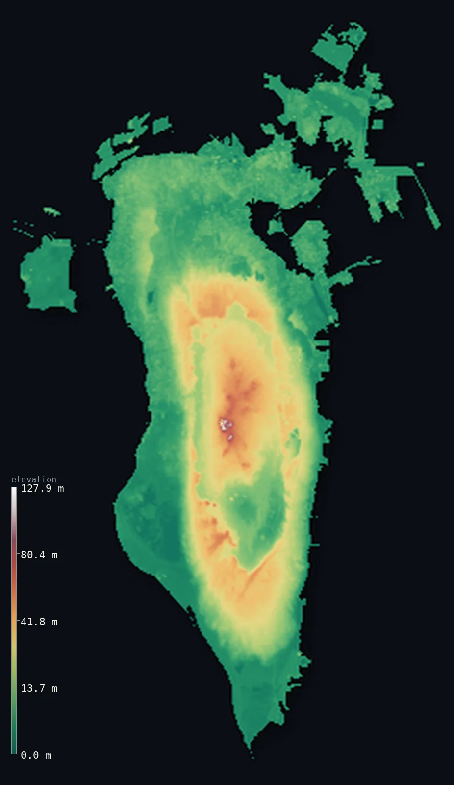
Bahrain’s highest point is Jabal ad Dukhan (Mountain of Smoke) at 440 ft (134 m); its lowest is Persian Gulf at 0 ft (0 m); the mean elevation is 46 ft (14 m).
Bahrain is a low, flat desert archipelago — more than thirty islands in the Persian Gulf, most of them barely above the tide. Bahrain Island, about three-quarters of the country, is a low dome of raised beaches rising gently inland to inward-facing limestone cliffs that ring a central depression; at its core the land lifts to Jabal ad Dukhan, the 'Mountain of Smoke', just 440 ft (134 m) high. So little of the country stands above the sea that half of it lies below about 23 ft (7 m). The capital, Manama, sits on reclaimed flats at the northern tip, linked by causeways to Muharraq and to Saudi Arabia.
- Highest point📚
- 440 ft134 m
- Bahrain's highest point is Jabal ad Dukhan — the 'Mountain of Smoke' — at 440 ft (134 m), a low limestone hill in the centre of Bahrain Island, ringed by the country's oil fields and named for the haze that often wreathes it. At 134 m it is a hill, not a mountain.
- Lowest point📚
- 0 ft0 m
- Bahrain's lowest point is sea level, all around this low Gulf archipelago. Most of the land — including the capital, Manama, on reclaimed northern flats — lies within a few metres of the sea.
- Mean elevation⚙
- 46 ft14 m
- Computed from the GLO-30 model, Bahrain's mean elevation is 46 ft (14 m) — very low, for Bahrain is a low, flat desert archipelago. Half the islands lie below about 23 ft (7 m), within a few metres of the Gulf; the land rises only to Jabal ad Dukhan at 134 m.
- Median elevation⚙
- 23 ft7 m
- Half of Bahrain lies below about 23 ft (7 m) — most of the archipelago is barely above the Gulf, a low desert of raised beaches and limestone flats, rising only gently to the central hill of Jabal ad Dukhan.
- Elevation range📚
- 440 ft134 m
- From sea level to Jabal ad Dukhan's 134 m, Bahrain's terrain spans only about 440 ft — a very small range, the low relief of a flat Gulf archipelago.
- Above 50 m (164 ft)⚙
- 3%
- About 3% of Bahrain rises above 50 m (164 ft) — the low central escarpment of Bahrain Island around Jabal ad Dukhan. Almost the whole archipelago lies lower, within a few metres of the Gulf.
- Official area📚
- 300 mi²778 km²
- Bahrain covers about 300 sq mi (778 sq km) — a small, flat, arid archipelago of more than 30 low islands in the Persian Gulf, Bahrain Island making up about three-quarters of the land, joined by Muharraq, Sitra and others.
- Forest cover📚
- 0.8%
- About 1% of Bahrain is wooded — almost entirely desert scrub, with a thin fertile date-palm strip along the north coast fed by springs and aquifers.
Highest and lowest points
Bahrain's highest point is Jabal ad Dukhan, the 'Mountain of Smoke', at 440 ft (134 m) — a low limestone hill in the Southern Governorate of Bahrain Island, named for the haze that often wreathes its summit on humid days. At 134 m it is really a hill rather than a mountain, the high core of a low desert dome. Bahrain's first oil well — the first in the Arabian Gulf region — was drilled on its slopes in 1932, and most of the country's oil fields lie around it. From this modest rise the land slopes gently down in every direction to the flat, reclaimed coasts.
source ↗Bahrain's lowest ground is the shore of its islands, at sea level all around this low Gulf archipelago. The capital, Manama, sits at the northern tip of Bahrain Island on reclaimed coastal flats, linked to Muharraq by causeways and to Saudi Arabia by the 25 km King Fahd Causeway. Inland, Bahrain Island rises so gently it is hard to see: a low desert dome of raised beaches and coquina lifting to a central escarpment, and at its core the limestone hill of Jabal ad Dukhan (134 m, the highest point), ringed by oil fields and salt marshes. The northern coast holds a thin fertile strip of date palms; the outer and southern islands, including the low Hawar group near Qatar, sit in shallow, reef-fringed seas.
source ↗Bahrain at a glance
Bahrain's highest point, Jabal ad Dukhan, is only 134 m — a low limestone hill rather than a mountain, named the 'Mountain of Smoke' for the haze that wreathes it on humid days.
source ↗The first oil well in the Arabian Gulf region was drilled on the slopes of Jabal ad Dukhan in 1932, launching Bahrain's transformation into an oil producer.
source ↗Bahrain Island is shaped like a low dome — raised beaches rising to inward-facing cliffs that ring a central depression about 20 km long.
source ↗Bahrain has grown its own territory: land reclamation has added at least 80 km² since the 20th century, expanding the country from about 665 to over 780 km².
source ↗In the empty southern desert stands the Tree of Life — a lone mesquite more than 400 years old that survives with no known water source.
source ↗The shallow Gulf around the Hawar Islands hosts the world's largest breeding colony of Socotra cormorants and one of the biggest dugong aggregations outside Australia.
source ↗Bahrain Island is linked to Saudi Arabia by the 25 km King Fahd Causeway — one of the longest fixed sea crossings in the region.
source ↗
Elevation profile of Bahrain
The largest share of land, 58%, falls in the 0–10 m band, and 100% of the territory lies below 500 m (1,640 ft).
- 0–10 m (0–33 ft)59%
- 10–50 m (33–164 ft)38%
- above 50 m (164 ft)3%
Highest peaks of Bahrain
| Peak | Elevation | Range | Note |
|---|---|---|---|
| Jabal ad Dukhan (Mountain of Smoke)↗ | 440 ft134 m | central escarpment, Bahrain Island | Highest point of Bahrain; a limestone hill ringed by oil fields and salt marshes, named for the summer haze. |
Bahrain: Bahrain Island and its central dome, the northern strip, and the outer islands
Bahrain Island and the central dome
Most of Bahrain Island is low, barren desert: flat raised beaches of sand and coquina rising gradually inland to inward-facing limestone cliffs that ring a central depression. At its core the land lifts to Jabal ad Dukhan (134 m), the highest point, ringed by the country's oil fields — where the first oil well in the Gulf region was drilled in 1932.
The northern fertile strip and reclaimed coast
Along the north coast runs a fertile strip about five kilometres wide where date palms grow, fed by springs. Around Manama and Muharraq the coast has been heavily expanded by land reclamation — Bahrain has added at least 80 km² since the 20th century, growing from about 665 to over 780 km².
The outer islands and coral seas
Around the main island lie low satellites — Muharraq and Sitra, heavily urbanised and causeway-linked — and, in the shallow southern seas near Qatar, the low Hawar group, a seabird and dugong sanctuary fringed by coral reefs.
How to read this map
Color shows elevation; the raised relief shows real terrain. On this map Bahrain reads as a cluster of low islands barely above the Gulf — Bahrain Island the largest, its faint central rise marking the dome around Jabal ad Dukhan, with Muharraq and the other islands lower still.
Because the highest point is only 134 m, the 3D relief is the actual GLO-30 elevation data exaggerated so the low dome and the flat coasts show at all; the ×N relief slider controls how much. Tap anywhere to read that point's exact elevation. (Some low outer islets lie beyond the main view.)
City elevations in Bahrain
Bahrain's people crowd the low north of the main island and the causeway-linked islands — Manama, the capital, on the northern tip, with the island of Muharraq just across the water. The southern half of Bahrain Island, around Jabal ad Dukhan near Dār Kulayb, is emptier oil-field desert.
| City | Population | Elevation |
|---|---|---|
| Manamacapitalthe capital, on the northern tip of Bahrain Island, on reclaimed flats just above the Gulf ↗ | 147,074 | 26 ft8 m |
| Dār Kulaybin the centre of Bahrain Island, near the low escarpment of Jabal ad Dukhan ↗ | 65,466 | 30 ft9 m |
Elevation sampled at each city centre from the Copernicus GLO-30 model. Cities and population from GeoNames (CC-BY 4.0).
Bahrain in comparison
Bahrain's terrain rises 440 ft (134 m) from sea level to Jabal ad Dukhan (Mountain of Smoke) — about 2% of the height of Mount Everest, the world's highest point at 29,032 ft (8,849 m).
- Qatar's mean elevation is 84 ft — 38 ft higher; its high point, Qurayn Abu al Bawl, reaches 338 ft (103 m), 102 ft below. Qatar elevation map →
- Kuwait's mean elevation is 381 ft — 335 ft higher; its high point, Unnamed location (western Kuwait), reaches 1,004 ft (306 m), 564 ft above. Kuwait elevation map →
- The Bahamas's mean elevation is 8 ft — 38 ft lower; its high point, Mount Alvernia (Como Hill), reaches 207 ft (63 m), 233 ft below. The Bahamas elevation map →
Frequently asked questions
What is the highest point in Bahrain?
- Jabal ad Dukhan — the 'Mountain of Smoke' — at 440 ft (134 m), a low limestone hill in the centre of Bahrain Island, ringed by the country's oil fields.
Why is it called the Mountain of Smoke?
- Because a haze of mist or dust often wreathes its summit on humid days, giving the hill a smoke-like appearance — though at 134 m it is really a hill rather than a mountain.
What is the average elevation of Bahrain?
- Computed from the Copernicus GLO-30 model, the area-weighted mean is 46 ft (14 m). Bahrain is a low, flat desert archipelago whose highest point is only 134 m above the sea.
Is Bahrain flat?
- Almost entirely — Bahrain is a low, flat desert archipelago, its highest point, Jabal ad Dukhan, reaching only 134 m (440 ft).
How many islands make up Bahrain?
- Bahrain is an archipelago of more than 30 islands; Bahrain Island is by far the largest at about 78% of the land, joined by Muharraq, Sitra, Umm an Nasan and the Hawar group, among others.
What is the Tree of Life in Bahrain?
- A lone mesquite tree over 400 years old standing in the southern desert near Jabal ad Dukhan, famous for surviving in the arid landscape with no obvious source of water.
Has Bahrain grown in size?
- Yes — extensive land reclamation has added at least 80 km² since the 20th century, expanding the country from about 665 km² to over 780 km².
Is this a topographic, relief, contour, or elevation map of Bahrain?
- They describe the same thing — terrain height. This page renders Bahrain's actual elevation surface in interactive 3D (a relief or topographic view) and reports the elevation statistics computed from it; a contour map shows the same data as lines of equal height.
About this map
The terrain is rendered from the Copernicus GLO-30 digital elevation model (ESA), masked to the BHR-ADM0 boundary from geoBoundaries (gbOpen). Elevation statistics are computed directly from the model; peak names and researched facts are sourced and cited. See the methodology for the full pipeline.
Our area-weighted mean, computed from the Copernicus GLO-30 model, is 46 ft (14 m); no authority publishes a mean elevation (CIA World Factbook (no published mean)). Bahrain is a low, flat desert archipelago — more than thirty islands in the Persian Gulf, most of them barely above the tide. Bahrain Island, about three-quarters of the country, is a low dome of raised beaches rising gently inland to inward-facing limestone cliffs that ring a central depression; at its core the land lifts to Jabal ad Dukhan, the 'Mountain of Smoke', just 134 m high. So little of the country stands above the sea that half of it lies below about 23 ft (7 m). No standard reference publishes a mean elevation for so flat a place; the figure here is computed directly from the GLO-30 model.
Surveyed national figures: official area · forest cover · high point.
Rendered from Copernicus GLO-30 (ESA, 2021 release), boundaries from geoBoundaries. Generated 2026-07-09.