Kuwait Elevation Map — Topographic & 3D Terrain
Explore the terrain of Kuwait in interactive 3D, built from Copernicus GLO-30 satellite elevation data — one of the flattest countries on Earth, a low desert sloping from the Persian Gulf to its western edge. Drag to rotate, scroll to zoom, and tap any point to read its elevation.
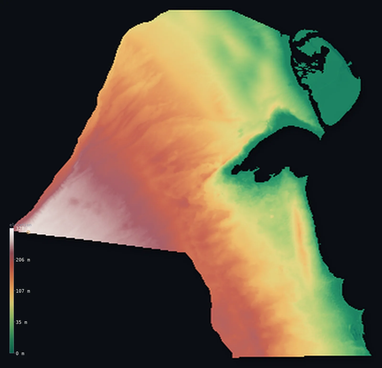
Kuwait’s highest point is Unnamed location (western Kuwait) at 1,004 ft (306 m); its lowest is Persian Gulf at 0 ft (0 m); the mean elevation is 381 ft (116 m).
Kuwait is one of the flattest countries on Earth — a barren desert of gravel and sand at the head of the Persian Gulf, between Iraq and Saudi Arabia. From the low coast, deeply indented by Kuwait Bay, the land rises almost imperceptibly westward — half the country lying below about 358 ft (109 m) — to reach its highest at an unnamed, featureless point of about 1,004 ft (306 m) near the Saudi border. There are no mountains and no permanent rivers, only a scatter of low ridges, like the Mutla Ridge near Al Jahra, often wrongly called the country's highest though it stands far lower.
- Highest point📚
- 1,004 ft306 m
- Kuwait's highest point is an unnamed desert rise of about 1,004 ft (306 m) in the far western desert, near the Saudi border, where the land slopes up to its westernmost edge — a featureless high point with no name and no real summit. The well-known Mutla Ridge (~142 m) is much lower.
- Lowest point📚
- 0 ft0 m
- Kuwait's lowest point is sea level, along its Persian Gulf coast, deeply indented by Kuwait Bay. The capital, Kuwait City, sits on the low southern shore of the bay, barely above the water.
- Mean elevation⚙
- 381 ft116 m
- Computed from the GLO-30 model, Kuwait's mean elevation is 381 ft (116 m) — low, for Kuwait is one of the flattest countries: a desert plain sloping gently up from the Persian Gulf to about 306 m at its far western edge. Half the country lies below about 358 ft (109 m).
- Median elevation⚙
- 358 ft109 m
- Half of Kuwait lies below about 358 ft (109 m) — the country is a near-level desert, rising almost imperceptibly westward from the Gulf coast to an unnamed high point of about 306 m near the Saudi border. There are no mountains and no permanent rivers.
- Elevation range📚
- 1,004 ft306 m
- From the Gulf to about 306 m in the far west, Kuwait's terrain spans about 1,004 ft — a gentle, almost imperceptible rise across the whole width of the country, from the coast to the western desert edge.
- Official area📚
- 6,880 mi²17,818 km²
- Kuwait covers about 6,880 sq mi (17,818 sq km) — a small, flat desert state at the head of the Persian Gulf, between Iraq and Saudi Arabia, its low coast deeply cut by Kuwait Bay and fringed by low offshore islands.
- Forest cover📚
- 0.4%
- Effectively no forest — Kuwait is almost entirely bare desert of gravel and sand, with no permanent rivers or lakes, only scattered scrub and a little irrigated farmland in the south.
Highest and lowest points
Kuwait's highest point is not a hill anyone climbs: it is an unnamed, featureless rise of about 1,004 ft (306 m) in the far western desert near the Saudi border, where the plain reaches its highest before the land continues to rise on the Saudi side. It has no name and no topographic prominence. The Mutla Ridge (~142 m), overlooking Al Jahra, is Kuwait's most prominent named hill and is often wrongly called its highest point — but it stands less than half as high as the western rise. Kuwait is, in truth, one of the flattest countries on Earth, and its high point is simply where the gentle desert slope meets the border.
source ↗Kuwait's lowest ground is its Persian Gulf coastline, at sea level, deeply indented by Kuwait Bay — the only deepwater harbour on the western Gulf, sheltering the country's main port. Offshore lie ten low islands, the largest being Bubiyan and Warbah on the northern tidal flats. From the coast the desert rises almost imperceptibly westward, a near-level plain of gravel and sand, to an unnamed high point of about 306 m at the far western edge near the Saudi border — the highest ground in a country that is otherwise flat. The most prominent relief is not the high point but the low ridges near the coast: the Jal az-Zor escarpment above Kuwait Bay and the Mutla Ridge (about 142 m) near Al Jahra.
source ↗Unnamed location (western Kuwait) is a border summit: its peak lies about 4 km outside the generalized Kuwait boundary, so the highest fully in-territory land pixel in the model is 961 ft (293 m). The headline figure above is the surveyed elevation of the recognised national high point.
Kuwait at a glance
Kuwait's highest point is an unnamed, featureless desert rise of about 306 m near the western border - it has no real summit and no name.
source ↗The Mutla Ridge, often called Kuwait's highest point, is actually only about 142 m - prominent, but far below the unnamed western high point.
source ↗Kuwait has no permanent rivers or lakes at all - only wadis that briefly fill during winter rains.
source ↗Kuwait Bay is the only deepwater harbour on the western shore of the Persian Gulf, and accounts for nearly a third of the country's coastline.
source ↗Bubiyan, Kuwait's largest island, is a flat expanse of tidal mudflats so low it is almost entirely uninhabited.
source ↗The terrain is so flat that the difference between the highest and lowest points across the whole country is only about 306 m.
source ↗
Elevation profile of Kuwait
The largest share of land, 13%, falls in the 0–20 m band, and 100% of the territory lies below 500 m (1,640 ft).
- below 500 m (1,640 ft)100%
Highest peaks of Kuwait
| Peak | Elevation | Range | Note |
|---|---|---|---|
| Unnamed high point (western desert)↗ | 1,004 ft306 m | Western desert (Saudi border) | The technical highest point of Kuwait - a featureless rise where the desert reaches its highest near the western border. |
| Jal az-Zor escarpment↗ | 476 ft145 m | Kuwait Bay (north) | A low cuesta escarpment rising above the northern shore of Kuwait Bay - among the most distinct relief in the country. |
| Mutla Ridge↗ | 466 ft142 m | Jahra Governorate (north) | Kuwait's most prominent named hill, overlooking Al Jahra - prominent but well below the western high point. |
Kuwait: the desert plain, the coast and Kuwait Bay, and the low ridges
The desert plain
Kuwait is a barren desert of gravel pavement, sand sheets and shallow wadis with very few hills. The land lies near sea level along the Persian Gulf and rises almost imperceptibly westward, reaching its highest — an unnamed point of about 306 m — at the far western edge near the Saudi border. There are no permanent rivers or lakes.
The coast and Kuwait Bay
The eastern edge is a low, marshy Persian Gulf coast deeply cut by Kuwait Bay — the only deepwater harbour on the western Gulf, sheltering the country's main port. Offshore lie ten low islands, the largest Bubiyan and Warbah on the northern tidal flats, most barely above the tide.
The low ridges
The only real relief is a scattering of low ridges: the Jal az-Zor escarpment above the north shore of Kuwait Bay (about 145 m), the prominent Mutla Ridge near Al Jahra (about 142 m), and the Ahmadi Ridge in the east over the great Burgan oil field — prominent, but all far below the western high point.
How to read this map
Color shows elevation; the raised relief shows real terrain. On this map Kuwait reads as an almost uniform low plain, tinted a little higher toward the west, where the desert reaches its high point near the Saudi border — with faint lines of relief at the Jal az-Zor escarpment and the Mutla Ridge near Kuwait Bay.
Because the country rises only about 300 m across its whole width, the 3D relief is the actual GLO-30 elevation data exaggerated strongly so the gentle slope and the low ridges show at all; the ×N relief slider controls how much. Tap anywhere to read that point's exact elevation.
City elevations in Kuwait
Kuwait's cities cluster on the coast around Kuwait Bay — Kuwait City, the capital, on the bay's low southern shore, with Al Ahmadi to the south over the great Burgan oil field, and Al Jahra at the western end of the bay, near the Mutla Ridge. Almost everyone lives near the coast; the western desert is nearly empty.
| City | Population | Elevation |
|---|---|---|
| Al Aḩmadīsouth of the capital, on the ridge over the great Burgan oil field ↗ | 637,411 | 236 ft72 m |
| Kuwait Citycapitalthe capital, on the low southern shore of Kuwait Bay, barely above the Gulf ↗ | 60,064 | 46 ft14 m |
| Al Jahrā’at the western end of Kuwait Bay, near the Mutla Ridge ↗ | 24,281 | 125 ft38 m |
| Al Wafrah | 10,017 | 531 ft162 m |
| Mazāri‘ al ‘Abdalī | 6,835 | 66 ft20 m |
| Al-Masayel | 2,458 | 26 ft8 m |
Elevation sampled at each city centre from the Copernicus GLO-30 model. Cities and population from GeoNames (CC-BY 4.0).
Kuwait in comparison
Kuwait's terrain rises 1,004 ft (306 m) from sea level to Unnamed location (western Kuwait) — about 3% of the height of Mount Everest, the world's highest point at 29,032 ft (8,849 m).
- Qatar's mean elevation is 84 ft — 297 ft lower; its high point, Qurayn Abu al Bawl, reaches 338 ft (103 m), 666 ft below. Qatar elevation map →
- Bahrain's mean elevation is 46 ft — 335 ft lower; its high point, Jabal ad Dukhan (Mountain of Smoke), reaches 440 ft (134 m), 564 ft below. Bahrain elevation map →
- Iraq's mean elevation is 974 ft — 594 ft higher; its high point, Cheekha Dar, reaches 11,847 ft (3,611 m), 10,843 ft above. Iraq elevation map →
Frequently asked questions
What is the highest point in Kuwait?
- An unnamed desert rise of about 1,004 ft (306 m) near the western border - flat-topped and without a name. The well-known Mutla Ridge (~142 m) is much lower.
What is the average elevation of Kuwait?
- Computed from the Copernicus GLO-30 model, the area-weighted mean is 381 ft (116 m). Kuwait is almost entirely flat, low desert.
What is the lowest point in Kuwait?
- Sea level, along its Persian Gulf coast.
Is Kuwait flat?
- Almost entirely - it is one of the flattest countries on Earth, a desert plain rising only to about 306 m at its far western edge.
Is the Mutla Ridge the highest point in Kuwait?
- No - the Mutla Ridge (~142 m) is Kuwait's most prominent hill, but the true highest point is an unnamed rise of about 306 m near the western border.
Is this a topographic, relief, contour, or elevation map of Kuwait?
- They describe the same thing - terrain height. This page renders Kuwait's actual elevation surface in interactive 3D (a relief or topographic view) and reports the elevation statistics computed from it; a contour map shows the same data as lines of equal height.
About this map
The terrain is rendered from the Copernicus GLO-30 digital elevation model (ESA), masked to the KWT-ADM0 boundary from geoBoundaries (gbOpen). Elevation statistics are computed directly from the model; peak names and researched facts are sourced and cited. See the methodology for the full pipeline.
Our area-weighted mean, computed from the Copernicus GLO-30 model, is 381 ft (116 m); the figure commonly cited elsewhere is 354 ft (108 m) (CIA World Factbook). Kuwait is one of the flattest countries on Earth — a barren desert of gravel pavement and sand sheets at the head of the Persian Gulf. From the low coast it rises almost imperceptibly westward, reaching its highest at an unnamed, featureless point of about 306 m near the Saudi border. Half the country lies below about 358 ft (109 m). The only real relief is a scatter of low ridges — the Jal az-Zor escarpment above Kuwait Bay and the prominent Mutla Ridge near Al Jahra (about 142 m, often wrongly called the country's highest, though it is far lower than the western rise). There are no mountains, no permanent rivers, and no lakes.
Surveyed national figures: official area · forest cover · high point.
Rendered from Copernicus GLO-30 (ESA, 2021 release), boundaries from geoBoundaries. Generated 2026-06-23.
Bordering countries · 2
Kuwait shares a land border with these countries — open any one to compare its terrain and highest point.