Saudi Arabia Elevation Map — Topographic & 3D Terrain
Explore the terrain of Saudi Arabia in interactive 3D, built from Copernicus GLO-30 satellite elevation data — a vast tilted plateau with a mountain wall along its western edge. Drag to rotate, scroll to zoom, and tap any point to read its elevation.
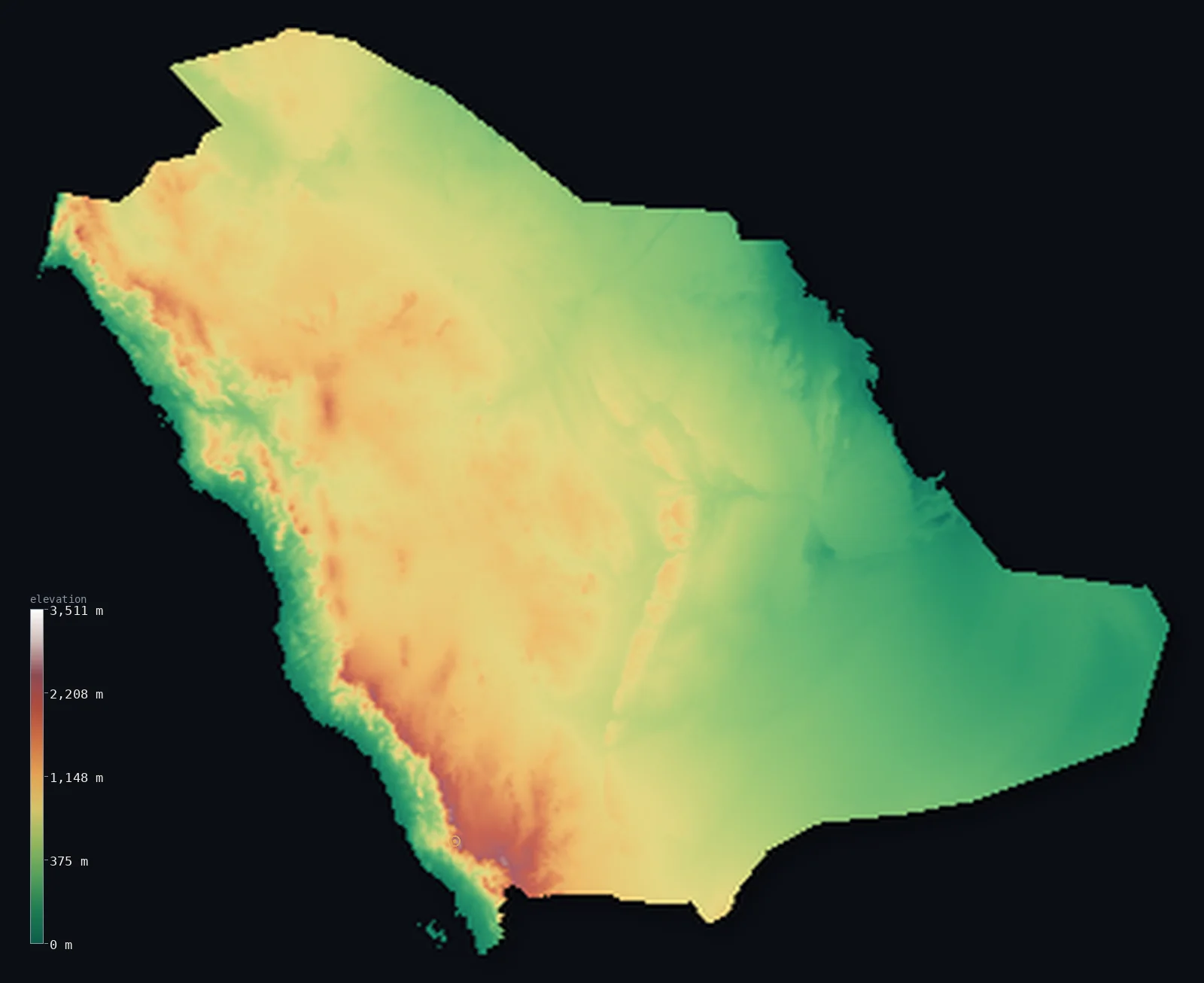
Saudi Arabia’s highest point is Jabal Sawda at 9,892 ft (3,015 m); its lowest is Persian Gulf at 0 ft (0 m); the mean elevation is 2,093 ft (638 m).
Saudi Arabia tilts. A wall of mountains runs down the entire Red Sea coast, and from its crest the land slopes east across hundreds of kilometres of plateau and sand toward the Persian Gulf. The country is higher than its reputation suggests — 15% of it stands above 3,281 ft (1,000 m), more than any of its Saharan neighbours — and it holds the Rub' al Khali, the largest continuous sand desert on Earth. It also has not a single permanent river.
- Highest point📚
- 9,892 ft3,015 m
- Saudi Arabia's highest point is Jabal Sawda at 9,892 ft (3,015 m), on the Asir escarpment above the Red Sea — high enough to be cool and green, with juniper forest and terraced farming, in a country otherwise defined by desert.
- Lowest point📚
- 0 ft0 m
- Saudi Arabia's lowest point is the Persian Gulf at sea level, at the far end of the country's eastward tilt — though inland sabkhas, salt flats in the eastern lowlands, dip a few metres below the tide.
- Mean elevation⚙
- 2,093 ft638 m
- Saudi Arabia's mean elevation computed from the GLO-30 model is 2,093 ft (638 m) — high for a country most people picture as flat sand, because the western mountains and the raised Najd plateau behind them lift most of the interior well above the sea.
- Median elevation⚙
- 2,129 ft649 m
- Half of Saudi Arabia lies above 2,129 ft (649 m) — slightly higher than the mean, an unusually symmetric distribution that says the country has no dominant low ground: the plateau simply carries most of the land at a similar height.
- Elevation range📚
- 9,892 ft3,015 m
- From the Gulf shore to the summit of Jabal Sawda, Saudi Arabia spans about 9,900 ft — and nearly all of it is gained in the west, where the Asir escarpment rises from the Red Sea in a single steep step.
- Above 1,000 m (3,281 ft)⚙
- 15%
- About 15% of Saudi Arabia rises above 1,000 m (3,281 ft) — the highest share of any large Arabian or Saharan country, taking in the Asir and Hijaz mountains along the Red Sea and much of the Najd plateau behind them.
- Official area📚
- 830,000 mi²2,149,690 km²
- Saudi Arabia covers about 830,000 sq mi (2,149,690 sq km) — most of the Arabian Peninsula, and within it the Rub' al Khali, the largest continuous body of sand on the planet.
- Forest cover📚
- 0.5%
- About 0.5% of Saudi Arabia is forested — and what exists clings almost entirely to the western escarpment, where the Asir mountains catch enough monsoon moisture to support juniper and acacia woodland.
Highest and lowest points
Saudi Arabia's highest point is Jabal Sawda, 9,892 ft (3,015 m), on the Asir escarpment near Abha in the southwest — and its exact height is genuinely uncertain. The official figure is 3,015 m, but other surveys have given values above 3,100 m, and the nearby peak of Jabal Ferwa may in fact be higher. What is not in doubt is the character of the place: at this altitude the Asir catches monsoon moisture off the Red Sea, and the slopes carry juniper forest, terraced fields, and cloud — a landscape that looks nothing like the rest of the country.
source ↗Saudi Arabia's lowest point is the Persian Gulf at sea level, on the eastern side of the country's long tilt. The Gulf coast is flat, hot, and shallow, fringed with sabkhas — salt flats where the water table sits at the surface and the crust dips a few metres below sea level. It is the drainage end of a country with no permanent rivers at all: what rain falls in the western mountains runs east through dry wadis and disappears into the sand long before it reaches the sea.
source ↗Saudi Arabia at a glance
Jabal Sawda's exact height is disputed - the official figure is 3,015 m, but other surveys give over 3,100 m, and the nearby Jabal Ferwa may be higher still.
source ↗Saudi Arabia has no permanent rivers - rain that falls in the western mountains runs east through dry wadis and vanishes into the sand.
source ↗The Rub' al Khali, the Empty Quarter, is the largest continuous sand desert on Earth, covering much of the country's south.
source ↗About 15% of Saudi Arabia rises above 1,000 m - a higher share than any of the Saharan countries to its west.
source ↗The Asir mountains in the southwest catch monsoon moisture from the Red Sea, supporting juniper forest and terraced farming at altitude.
source ↗The whole country tilts eastward: from the Red Sea escarpment the land slopes down across the Najd plateau to the flat Gulf coast.
source ↗
Elevation profile of Saudi Arabia
The largest share of land, 20%, falls in the 800–1,000 m band, and 61% of the territory lies above 500 m (1,640 ft).
- below 500 m (1,640 ft)39%
- 500–1,000 m46%
- 1,000–2,000 m15%
- above 2,000 m (6,562 ft)1%
Highest peaks of Saudi Arabia
| Peak | Elevation | Range | Note |
|---|---|---|---|
| Jabal Ferwa↗ | 10,171 ft3,100 m | Asir Mountains (Sarawat) | A neighbouring Asir summit that a 2018 satellite survey suggested may slightly exceed Jabal Sawda. |
| Jabal Sawda↗ | 9,892 ft3,015 m | Asir Mountains (Sarawat) | Officially the highest point of Saudi Arabia, in the Asir highlands west of Abha. |
| Jabal al-Lawz↗ | 8,363 ft2,549 m | Midian Mountains (northwest) | The high peak of the Midian Mountains near Tabuk in the far northwest, snow-capped in winter. |
| Jabal Aja↗ | 5,066 ft1,544 m | Jibal Aja (Najd, Hail) | The highest peak of the Najd plateau, rising above the city of Hail. |
| Fareeda al-Shazia (Tuwayq)↗ | 3,924 ft1,196 m | Tuwayq escarpment (Najd) | The high point of the long Tuwayq escarpment that arcs through Najd west of Riyadh. |
From the Red Sea wall to the Gulf lowlands
The Red Sea escarpment (Hijaz and Asir)
A mountain wall runs the entire length of the western coast, rising abruptly from a narrow coastal plain — the Hijaz in the north, the higher Asir in the south, where Jabal Sawda stands. The Asir is the wettest, greenest, and coolest part of Saudi Arabia, terraced and forested at altitude.
The Najd plateau
Behind the escarpment lies the Najd, a broad interior plateau of rock and gravel between roughly 600 and 1,500 m, cut by dry wadis and studded with escarpments. Riyadh sits on it, and it is what makes the country's average elevation so high.
The Rub' al Khali and the sand seas
The south is the Empty Quarter — the largest continuous sand desert in the world, an ocean of dunes with almost no permanent settlement. Two more sand seas, the Nafud in the north and the Dahna arc between them, wrap around the plateau's edges.
The Gulf lowlands
In the east the plateau falls away to a flat, hot coastal plain along the Persian Gulf — low, salt-crusted, and dotted with sabkhas, where the country's oil fields and its lowest ground both lie.
How to read this map
Color shows elevation; the raised relief shows real terrain. On this map Saudi Arabia reads as a sharp brown wall along the Red Sea fading eastward through the plateau's mid-tones to the pale flat ground of the Gulf coast, with the smooth expanse of the Empty Quarter filling the south.
The 3D relief is the actual GLO-30 elevation data, exaggerated vertically so the western escarpment and the plateau's gentle tilt both show; the ×N relief slider controls how much. Tap anywhere to read that point's exact elevation.
City elevations in Saudi Arabia
Saudi cities split by the tilt. Riyadh stands high on the Najd plateau at about 2,000 ft, and the southwestern highland towns higher still, while Jeddah on the Red Sea and the Gulf cities of Dammam and Dhahran sit close to sea level at either end of the slope.
| City | Population | Elevation |
|---|---|---|
| Jeddahon the Red Sea coast at sea level, below the Hijaz escarpment ↗ | 4,697,000 | 16 ft5 m |
| Riyadhcapitalthe capital, high on the Najd plateau at about 600 m ↗ | 4,205,961 | 2,008 ft612 m |
| Madinah | 1,300,000 | 1,985 ft605 m |
| Dammam | 1,252,523 | 30 ft9 m |
| Buraydah | 745,353 | 1,995 ft608 m |
| Ta’if | 688,693 | 5,482 ft1,671 m |
| Tabuk | 667,000 | 2,520 ft768 m |
| Ha'il | 605,930 | 3,278 ft999 m |
| Najrān | 505,652 | 4,281 ft1,305 m |
| Khamis Mushait | 387,553 | 6,542 ft1,994 m |
Elevation sampled at each city centre from the Copernicus GLO-30 model. Cities and population from GeoNames (CC-BY 4.0).
Saudi Arabia in comparison
Saudi Arabia's terrain rises 9,892 ft (3,015 m) from sea level to Jabal Sawda — about 34% of the height of Mount Everest, the world's highest point at 29,032 ft (8,849 m).
- Yemen's mean elevation is 3,081 ft — 988 ft higher; its high point, Jabal an-Nabi Shuayb, reaches 12,028 ft (3,666 m), 2,136 ft above. Yemen elevation map →
- Oman's mean elevation is 902 ft — 1,191 ft lower; its high point, Jabal Shams, reaches 9,872 ft (3,009 m), 20 ft below. Oman elevation map →
- Iraq's mean elevation is 974 ft — 1,119 ft lower; its high point, Cheekha Dar, reaches 11,847 ft (3,611 m), 1,955 ft above. Iraq elevation map →
Frequently asked questions
What is the highest point in Saudi Arabia?
- Jabal Sawda, 9,892 ft (3,015 m), on the Asir escarpment in the southwest - though its exact height is disputed, with some surveys giving over 3,100 m.
What is the lowest point in Saudi Arabia?
- The Persian Gulf at sea level, at the eastern end of the country's tilt - inland salt flats dip a few metres below it.
What is the average elevation of Saudi Arabia?
- Computed from the Copernicus GLO-30 model, the area-weighted mean is 2,093 ft (638 m) - high, because the western mountains and the Najd plateau lift most of the interior.
Does Saudi Arabia have any rivers?
- No permanent ones. Rain falling on the western mountains runs east through dry wadis and soaks away into the sand before reaching the sea.
How big is the Rub' al Khali?
- It is the largest continuous sand desert on Earth, covering much of southern Saudi Arabia and spilling into neighbouring countries.
Is this a topographic, relief, contour, or elevation map of Saudi Arabia?
- They describe the same thing - terrain height. This page renders the country's actual elevation surface in interactive 3D and reports the statistics computed from it.
About this map
The terrain is rendered from the Copernicus GLO-30 digital elevation model (ESA), masked to the SAU-ADM0 boundary from geoBoundaries (gbOpen). Elevation statistics are computed directly from the model; peak names and researched facts are sourced and cited. See the methodology for the full pipeline.
Our area-weighted mean, computed from the Copernicus GLO-30 model, is 2,093 ft (638 m); the figure commonly cited elsewhere is 2,182 ft (665 m) (CIA World Factbook). Saudi Arabia is a vast tilted block - highest along the western mountains and sloping gradually east across the Najd plateau to the low Gulf coast - so even with extensive deserts its mean elevation is moderate; the page reports the area-weighted figure computed from the Copernicus GLO-30 model.
Surveyed national figures: official area · forest cover · high point.
Rendered from Copernicus GLO-30 (ESA, 2021 release), boundaries from geoBoundaries. Generated 2026-06-26.
Bordering countries · 8
Saudi Arabia shares a land border with these countries — open any one to compare its terrain and highest point.
- Egypt↑ Mount Catherine (Gebel Katherina), 2,629 m
- Iraq↑ Cheekha Dar, 3,611 m
- Jordan↑ Jabal Umm ad Dami, 1,854 m
- Kuwait↑ Unnamed location (western Kuwait), 306 m
- Oman↑ Jabal Shams, 3,009 m
- Qatar↑ Qurayn Abu al Bawl, 103 m
- United Arab Emirates↑ Jebel Jais (UAE high point), 1,892 m
- Yemen↑ Jabal an-Nabi Shuayb, 3,666 m