Jordan Elevation Map — Topographic & 3D Terrain
Explore the terrain of Jordan in interactive 3D, built from Copernicus GLO-30 satellite elevation data — a country of high desert plateau dropping to the Dead Sea, the lowest land on Earth. Drag to rotate, scroll to zoom, and tap any point to read its elevation.
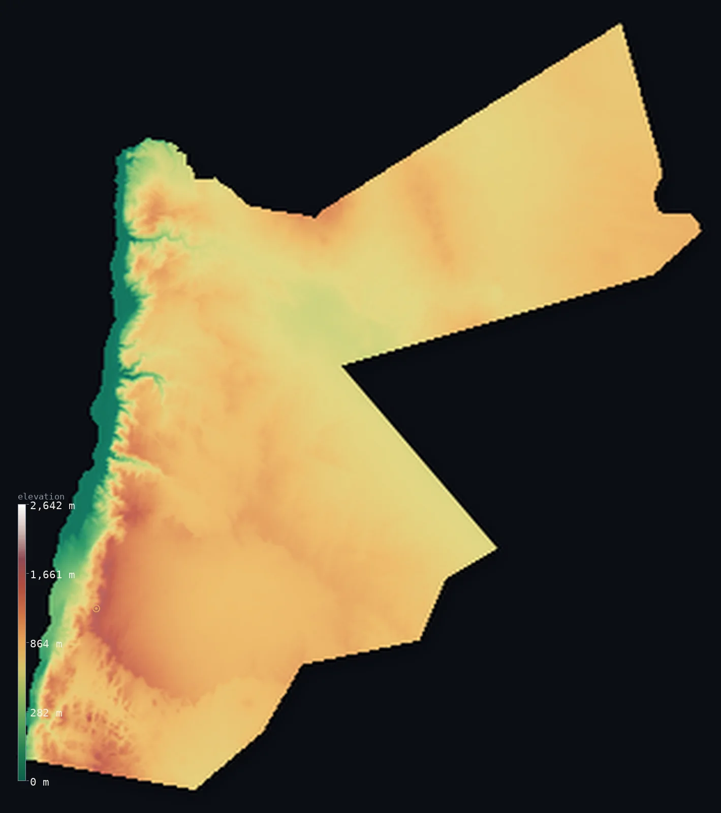
Jordan’s highest point is Jabal Umm ad Dami at 6,083 ft (1,854 m); its lowest is Dead Sea shore at −1,411 ft (−430 m); the mean elevation is 2,520 ft (768 m).
Jordan is a country of high desert plateau and deep rift, in the heart of the Middle East. Most of it is an elevated plateau — the vast, arid Badia, a stony desert tableland sitting mostly above 2,300 ft, sloping east into Arabia. But along Jordan's entire western edge runs the great Jordan Rift Valley, dropping sharply to the River Jordan, the Sea of Galilee, and the Dead Sea — whose shore, shared with Israel to the west, lies about 1,411 ft (430 m) below sea level, the lowest dry land on the surface of the Earth. In the far south, mountains rise again toward the Red Sea at Aqaba, holding Jordan's highest point, Jabal Umm ad Dami, at 6,083 ft (1,854 m). So the land is high plateau cut by the great rift that holds the lowest land on Earth — and more than half of Jordan lies above about 2,602 ft (793 m).
- Highest point📚
- 6,083 ft1,854 m
- Jordan's highest point is Jabal Umm ad Dami at 6,083 ft (1,854 m), in the far south of the country near the border with Saudi Arabia, in the desert mountains above Wadi Rum. It is a sandstone-and-granite peak in the dramatic desert-mountain landscape of Jordan's south — the high point of a country that is mostly high plateau, rising here, in the south, to its greatest heights above the famous red desert of Wadi Rum.
- Lowest point📚
- −1,411 ft−430 m
- Jordan's lowest point — and the lowest dry land anywhere on Earth — is the shore of the Dead Sea, at about 1,411 ft (430 m) below sea level, on Jordan's western edge. The Dead Sea lies in the deepest part of the great Jordan Rift Valley, a hypersaline lake shared with Israel on its western shore, its surface dropping year by year. From this extraordinary low, Jordan's land climbs east onto the high plateau.
- Mean elevation⚙
- 2,520 ft768 m
- Computed from the GLO-30 model, Jordan's mean elevation is 2,520 ft (768 m) — a fairly high figure, for most of Jordan is elevated desert plateau. More than half the country lies above about 2,602 ft (793 m): the vast plateau is the rule, and only the deep Jordan Rift Valley in the west drops low — to the Dead Sea, the lowest land on Earth — pulling the average below the plateau's typical height.
- Median elevation⚙
- 2,602 ft793 m
- More than half of Jordan lies above about 2,602 ft (793 m) — and this is higher than the mean, because Jordan is mostly high plateau: the vast arid Badia tableland covers most of the country and sits high, while only the deep Jordan Rift Valley in the west drops sharply to the Dead Sea, the lowest land on Earth, pulling the average down below the midpoint.
- Elevation range📚
- 7,493 ft2,284 m
- From the Dead Sea shore at 430 m below sea level to Jabal Umm ad Dami at 1,854 m above it, Jordan's terrain spans about 7,493 ft — from the lowest dry land on the planet, in the Jordan Rift, up to the desert mountains of the far south above Wadi Rum.
- Above 1,000 m (3,281 ft)⚙
- 10%
- About 10% of Jordan rises above 1,000 m (3,281 ft) — much of the elevated plateau, especially the higher western highlands overlooking the rift and the southern desert mountains. The rift valley in the west and the lower eastern desert lie below.
- Official area📚
- 34,495 mi²89,342 km²
- Jordan covers about 34,495 sq mi (89,342 sq km) — a Middle Eastern country of high, arid desert plateau (the Badia), cut along its western edge by the great Jordan Rift Valley that drops to the Dead Sea (the lowest land on Earth), and rising in the far south to desert mountains above Wadi Rum (holding Jabal Umm ad Dami).
- Forest cover📚
- 1.1%
- About 1.1% of Jordan is forested — very little, for Jordan is mostly desert; what woodland there is clings to the higher western highlands above the rift (pine and oak on the hills near Ajloun), while the vast eastern and southern country is arid steppe and desert.
Highest and lowest points
Jordan's highest point is Jabal Umm ad Dami, 6,083 ft (1,854 m), a desert mountain in the far south of the country, near the border with Saudi Arabia and rising above the famous red sandscape of Wadi Rum. It is a peak of sandstone and granite in Jordan's dramatic southern desert-mountain country — the highest ground in a nation that is otherwise mostly high plateau. Jordan has no great mountain ranges; its terrain is a high, arid tableland, cut on the west by the deep Jordan Rift (dropping to the Dead Sea, the lowest land on Earth) and rising, here in the south above Wadi Rum, to its highest summit. From Umm ad Dami the land falls away toward the short Red Sea coast at Aqaba to the southwest, and stretches north and east across the desert plateau.
source ↗Jordan's lowest point is the shore of the Dead Sea, at about 1,411 ft (430 m) below sea level — the lowest dry land anywhere on the surface of the Earth — on the country's western edge. The Dead Sea, a hypersaline lake shared with Israel on its western shore, lies in the deepest part of the great Jordan Rift Valley, the geological trench that forms Jordan's entire western border (the River Jordan, the Sea of Galilee to the north, the Dead Sea, and the Wadi Araba south toward the Red Sea). But this deep rift is the exception in Jordan. Most of the country is high, arid plateau — the Badia, a vast stony desert tableland sitting mostly above 700 m, sloping gently east into the Arabian interior, broken by desert castles and oasis towns. Along the western rim of the plateau, overlooking the rift, run the higher highlands — greener, holding the capital Amman, the hills of Ajloun, and the ancient city of Petra carved into the rock. In the far south, beyond the desert of Wadi Rum with its towering sandstone, the land rises to Jordan's highest point, Jabal Umm ad Dami, near the Saudi border, before dropping to the short Red Sea coast at Aqaba. So Jordan runs from the lowest land on Earth, in its western rift, up across a high desert plateau.
source ↗Jordan at a glance
The shore of the Dead Sea, on Jordan's western edge, is about 430 m below sea level — the lowest dry land anywhere on the surface of the Earth, shared with Israel across the water.
source ↗Most of Jordan is high desert plateau — the vast arid Badia, a stony tableland sitting mostly above 700 m, sloping east into Arabia.
source ↗Jordan's western border is the great Jordan Rift Valley — the River Jordan, the Dead Sea, and the Wadi Araba — part of the Dead Sea Transform, one of the great rift systems of the Earth.
source ↗So much of Jordan is high plateau that its median elevation is higher than its mean — only the deep western rift drops low enough to pull the average down.
source ↗Jordan's highest point, Jabal Umm ad Dami (1,854 m), rises in the far south above Wadi Rum — the red desert of towering sandstone near the Saudi border.
source ↗The ancient city of Petra, carved into rose-red rock, sits in the highlands along the western rim of Jordan's plateau, above the rift.
source ↗
Elevation profile of Jordan
The largest share of land, 39%, falls in the 800–1,000 m band, and 93% of the territory lies above 500 m (1,640 ft).
- below 500 m (1,640 ft)7%
- 500–1,000 m83%
- 1,000–2,000 m10%
Highest peaks of Jordan
| Peak | Elevation | Range | Note |
|---|---|---|---|
| Jabal Umm ad Dami↗ | 6,083 ft1,854 m | Wadi Rum (south) | Highest point of Jordan, a sandstone-granite massif in the Wadi Rum desert near the Saudi border. |
| Jabal Ram (Jebel Rum)↗ | 5,755 ft1,754 m | Wadi Rum (south) | A towering sandstone massif above Wadi Rum village, a famous rock-climbing peak. |
| Jabal Mubarak↗ | 5,666 ft1,727 m | Southern Highlands | A high summit of the southern highlands near Petra, among the highest inhabited areas in Jordan. |
Jordan: the desert plateau, the Jordan Rift, and the highlands and southern mountains
The desert plateau — the Badia
Most of Jordan is high, arid plateau — the Badia, a vast stony desert tableland sitting mostly above 700 m, sloping east into Arabia, broken by oasis towns and desert castles. The high, dry body of the country.
The Jordan Rift Valley — the west
Along the entire western edge runs the great Jordan Rift Valley — the River Jordan, the Sea of Galilee, and the Dead Sea (the lowest land on Earth), dropping into the Wadi Araba toward the Red Sea. Jordan's deep western trench.
The highlands and the southern mountains
Along the western rim rise greener highlands — holding Amman, Ajloun, and Petra — and in the far south, desert mountains above Wadi Rum climb to Jabal Umm ad Dami (the high point). Jordan's higher western and southern edges.
How to read this map
Color shows elevation; the raised relief shows real terrain. On this map Jordan reads as a high plateau with a deep western trench — the broad mid-tone of the arid plateau (the Badia) filling most of the country and sloping east, the deep blue-and-below-sea band of the Jordan Rift dropping along the entire western edge to the Dead Sea (the lowest land on Earth), the higher western highlands along the rim, and the desert mountains rising in the far south (highest at Jabal Umm ad Dami above Wadi Rum). The Dead Sea shore lies far below sea level, shown in the below-sea band.
The 3D relief is the actual GLO-30 elevation data, exaggerated vertically so the plateau, the deep rift, and the southern mountains all show; the ×N relief slider controls how much. Tap anywhere to read that point's exact elevation.
City elevations in Jordan
Jordan's cities cluster in the highlands along the western rim of the plateau, above the rift — Amman, the capital, in the northern highlands, with Irbid to the north, and Aqaba on the Red Sea in the far south. Most of the population lives on the higher, greener western edge, above the deep rift and the eastern desert.
| City | Population | Elevation |
|---|---|---|
| Ammancapitalthe capital, in the northern highlands on the plateau's western rim ↗ | 1,275,857 | 2,520 ft768 m |
| Irbidin the northern highlands ↗ | 569,068 | 1,857 ft566 m |
| Aqabaon the Red Sea coast in the far south, Jordan's only seaport ↗ | 95,048 | 148 ft45 m |
| Mafraqon the northern desert plateau ↗ | 57,118 | 2,300 ft701 m |
| Ma'anin the southern highlands, near Petra and Wadi Rum ↗ | 50,350 | 3,642 ft1,110 m |
| Aţ Ţafīlah | 25,429 | 3,402 ft1,037 m |
| Al Azraq ash Shamālī | 14,800 | 1,699 ft518 m |
| Ruwaished | 9,805 | 2,257 ft688 m |
| Al Quwayrah | 7,372 | 2,664 ft812 m |
Elevation sampled at each city centre from the Copernicus GLO-30 model. Cities and population from GeoNames (CC-BY 4.0).
Jordan in comparison
Jordan's terrain rises 7,493 ft (2,284 m) from Dead Sea shore, 1,411 ft (430 m) below sea level to Jabal Umm ad Dami — about 26% of the height of Mount Everest, the world's highest point at 29,032 ft (8,849 m).
- Israel's mean elevation is 928 ft — 1,591 ft lower; its high point, Mount Meron, reaches 3,963 ft (1,208 m), 2,119 ft below. Israel elevation map →
- Lebanon's mean elevation is 3,271 ft — 751 ft higher; its high point, Qurnat as Sawda, reaches 10,131 ft (3,088 m), 4,049 ft above. Lebanon elevation map →
- Saudi Arabia's mean elevation is 2,093 ft — 427 ft lower; its high point, Jabal Sawda, reaches 9,892 ft (3,015 m), 3,809 ft above. Saudi Arabia elevation map →
Frequently asked questions
What is the highest point in Jordan?
- Jabal Umm ad Dami, 6,083 ft (1,854 m), a desert mountain in the far south near the Saudi border, above Wadi Rum — the high point of a mostly-high-plateau country.
What is the lowest point in Jordan?
- The shore of the Dead Sea, about 1,411 ft (430 m) below sea level — the lowest dry land anywhere on Earth, on Jordan's western edge (shared with Israel).
What is the lowest land on Earth?
- The shore of the Dead Sea, on the border of Jordan and Israel, at about 430 m below sea level — the lowest exposed land on the planet, in the deepest part of the Jordan Rift Valley.
What is the average elevation of Jordan?
- Computed from the Copernicus GLO-30 model, the area-weighted mean is 2,520 ft (768 m) — fairly high, because most of Jordan is elevated desert plateau. More than half the country lies above about 2,602 ft (793 m), higher than the mean, which is pulled down by the deep western rift.
Why is Jordan's median elevation higher than its mean?
- Because most of Jordan is high plateau — the vast Badia tableland sits high, so the typical point is high, while only the deep Jordan Rift Valley in the west drops low enough (to the Dead Sea) to pull the average down below the midpoint.
Is this a topographic, relief, contour, or elevation map of Jordan?
- They describe the same thing — terrain height. This page renders the country's actual elevation surface in interactive 3D and reports the statistics computed from it.
About this map
The terrain is rendered from the Copernicus GLO-30 digital elevation model (ESA), masked to the JOR-ADM0 boundary from geoBoundaries (gbOpen). Elevation statistics are computed directly from the model; peak names and researched facts are sourced and cited. See the methodology for the full pipeline.
Our area-weighted mean, computed from the Copernicus GLO-30 model, is 2,520 ft (768 m); the figure commonly cited elsewhere is 2,664 ft (812 m) (CIA World Factbook). Jordan is mostly a high place. The great arid plateau — the Badia, a stony desert tableland — covers most of the country and sits high, sloping east into Arabia. So high and uniform is this plateau that more than half of Jordan lies above about 2,602 ft (793 m), higher than the average — for the average is pulled down by the one great exception: the Jordan Rift Valley along the western edge, which drops sharply to the River Jordan and the Dead Sea, whose shore, at about 430 m below sea level, is the lowest dry land on Earth. In the far south, desert mountains rise again above Wadi Rum to Jabal Umm ad Dami, the highest point. So Jordan is high plateau and deep rift — most of it high, its one low a world record.
Surveyed national figures: official area · forest cover · high point.
Rendered from Copernicus GLO-30 (ESA, 2021 release), boundaries from geoBoundaries. Generated 2026-06-23.
Bordering countries · 4
Jordan shares a land border with these countries — open any one to compare its terrain and highest point.