Israel Elevation Map — Topographic & 3D Terrain
Explore the terrain of Israel in interactive 3D, built from Copernicus GLO-30 satellite elevation data — a country running from Mediterranean coast to the Dead Sea shore, the lowest land on Earth. Drag to rotate, scroll to zoom, and tap any point to read its elevation.
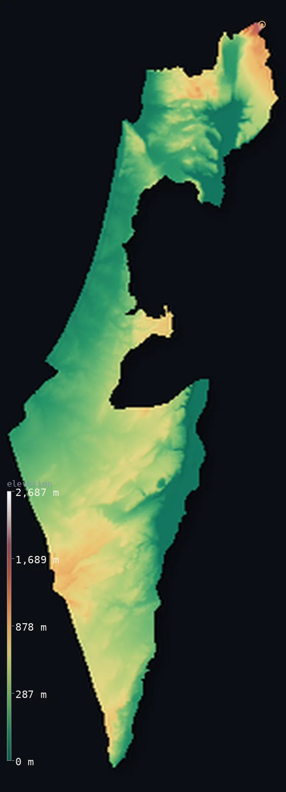
Israel’s highest point is Mount Meron at 3,963 ft (1,208 m); its lowest is Dead Sea shore at −1,411 ft (−430 m); the mean elevation is 928 ft (283 m).
Israel is a small country of great contrasts in terrain, running from the Mediterranean coast down to the shore of the Dead Sea — which, at about 1,411 ft (430 m) below sea level, is the lowest dry land on the surface of the Earth. Along the west lies a low, fertile coastal plain; inland rise the central hills and highlands; and in the east the land plunges into the great rift of the Jordan Valley and the Dead Sea. To the south spreads the arid Negev desert, narrowing to a point at the Red Sea. Israel's highest point within its internationally recognized borders is Mount Meron, at 3,963 ft (1,208 m), in the hills of Galilee in the north. Half the country lies below about 856 ft (261 m).
- Highest point📚
- 3,963 ft1,208 m
- The highest point within Israel's internationally recognized borders is Mount Meron at 3,963 ft (1,208 m), in the hills of Upper Galilee in the north of the country — a forested summit above the Galilee highlands. (Higher ground lies on the slopes of Mount Hermon, in the Golan Heights — territory occupied by Israel since 1967 — which reach above 2,200 m; but Meron is the highest point within Israel's recognized borders.)
- Lowest point📚
- −1,411 ft−430 m
- Israel's lowest point — and the lowest dry land anywhere on Earth — is the shore of the Dead Sea, at about 1,411 ft (430 m) below sea level. The Dead Sea lies in the deepest part of the great Jordan Rift Valley, a hypersaline lake shared with Jordan on its eastern shore, its surface dropping year by year. From this extraordinary low the land climbs west to the hills and the coast.
- Mean elevation⚙
- 928 ft283 m
- Computed from the GLO-30 model, Israel's mean elevation is 928 ft (283 m) — a modest figure for a country of such contrasts, because the low coastal plain and the below-sea Jordan Valley offset the central hills. Half the country lies below about 856 ft (261 m), on the coastal plain, in the northern valleys, and in the rift.
- Median elevation⚙
- 856 ft261 m
- Half of Israel lies below about 856 ft (261 m) — for much of the country is low: the Mediterranean coastal plain in the west, the valleys of the north, and, in the east, the deep Jordan Rift Valley that drops to the Dead Sea, the lowest land on Earth. The central hills and the higher Negev rise above.
- Elevation range📚
- 5,374 ft1,638 m
- From the Dead Sea shore at 430 m below sea level to Mount Meron at 1,208 m above it, Israel's terrain spans about 5,374 ft — a remarkable range for so small a country, from the lowest dry land on the planet up to the forested summit of Galilee.
- Above 1,000 m (3,281 ft)⚙
- 1%
- About 1% of Israel rises above 1,000 m (3,281 ft) — the Galilee hills (Mount Meron), the Negev highlands, and the occupied Golan slopes toward Mount Hermon, which the mapped polygon includes. Most of the country lies far lower.
- Official area📚
- 8,522 mi²22,072 km²
- Israel covers about 8,522 sq mi (22,072 sq km) — a small country running from the Mediterranean coastal plain, up through the central hills and highlands, down into the Jordan Rift Valley and the Dead Sea (the lowest land on Earth), and south into the arid Negev desert.
- Forest cover📚
- 7.6%
- About 7.6% of Israel is forested — a fairly lightly wooded country, with planted and natural Mediterranean woodland on the northern and central hills (the Galilee, the Carmel), and the arid Negev desert and semi-desert across much of the south.
Highest and lowest points
The highest point within Israel's internationally recognized borders is Mount Meron, 3,963 ft (1,208 m), a forested summit in the hills of Upper Galilee in the north of the country. Meron rises above the Galilee highlands, a region of Mediterranean woodland and hill country, and is the high point of northern Israel. (Higher ground lies to the northeast, on the slopes of Mount Hermon in the Golan Heights — territory Israel has occupied since 1967, where the Israeli-controlled slopes rise above 2,200 m; but within Israel's internationally recognized borders, Mount Meron is the highest point.) From Meron and the Galilee hills the land falls away west to the Mediterranean coast and, eastward, drops dramatically into the Jordan Rift Valley toward the Sea of Galilee — so that Israel's highest recognized summit stands not far from some of the lowest land on Earth.
source ↗Israel's lowest point is the shore of the Dead Sea, at about 1,411 ft (430 m) below sea level — the lowest dry land anywhere on the surface of the Earth. The Dead Sea is a hypersaline lake in the deepest part of the Jordan Rift Valley — the great geological trench that runs the length of eastern Israel, part of the larger system reaching from Syria to East Africa — and its shore, shared with Jordan to the east, keeps dropping as the sea shrinks. Israel's terrain runs in bands from this extraordinary low. Along the Mediterranean in the west lies a low, fertile, densely populated coastal plain. Inland rise the central hills and highlands — the hills of Galilee in the north (holding Mount Meron, the highest point within Israel's internationally recognized borders), the hills of Samaria and Judea, and the Carmel range by the sea. In the east, beyond the hills, the land drops sharply into the Jordan Valley, the Sea of Galilee, and the Dead Sea. To the south spreads the arid Negev desert, a highland of rock and canyon narrowing to Israel's short Red Sea coast at Eilat. (Higher ground than Meron lies on the slopes of Mount Hermon in the Golan Heights, occupied by Israel since 1967; the terrain shown follows Israel's internationally recognized borders.)
source ↗Israel at a glance
The Dead Sea shore, at about 430 m below sea level, is the lowest dry land anywhere on Earth - and Israel's lowest point.
source ↗Within its internationally recognized borders, Israel's highest point is Mount Meron (1,208 m); higher ground on the Golan Heights is regarded internationally as Syrian.
source ↗The Sea of Galilee, Israel's main freshwater lake, also lies below sea level, at about −689 ft (−210 m).
source ↗The whole eastern edge of Israel follows the Jordan Rift, part of a fault system that runs thousands of kilometres from Syria into East Africa.
source ↗More than half of Israel is desert - the Negev - yet the country runs from snow-dusted northern hills to the coral reefs of the Red Sea at Eilat.
source ↗Makhtesh Ramon in the Negev is the world's largest erosion crater (makhtesh), a landform almost unique to this region.
source ↗
Elevation profile of Israel
The largest share of land, 34%, falls in the 0–200 m band, and 79% of the territory lies below 500 m (1,640 ft).
- below 500 m (1,640 ft)79%
- 500–1,000 m20%
- 1,000–2,000 m1%
- above 2,000 m (6,562 ft)<1%
Highest peaks of Israel
| Peak | Elevation | Range | Note |
|---|---|---|---|
| Mount Meron↗ | 3,963 ft1,208 m | Upper Galilee | Highest point of Israel within its internationally recognized borders, in the Upper Galilee near Safed. |
| Mount Ramon↗ | 3,402 ft1,037 m | Negev Highlands (south) | The highest peak of the Negev desert, above the great erosion crater of Makhtesh Ramon. |
| Mount Tabor↗ | 1,886 ft575 m | Lower Galilee | A distinctive dome rising alone above the Jezreel Valley, a landmark of the Lower Galilee. |
Israel: the coastal plain, the central hills, and the Jordan Rift and Negev
The coastal plain — the west
Along the Mediterranean lies a low, fertile, densely populated coastal plain — the heart of Israel's population and cities, from the Lebanese border south past Tel Aviv and Ashdod. The low, populous western edge of the country.
The central hills — Galilee, Samaria, Judea, Carmel
Inland rise the central hills and highlands — the Galilee in the north (holding Mount Meron, the high point within recognized borders), the hills of Samaria and Judea, and the coastal Carmel range. Israel's upland spine.
The Jordan Rift and the Negev — the east and south
In the east the land drops into the Jordan Rift Valley — the Sea of Galilee and, at its deepest, the Dead Sea (the lowest land on Earth) — and to the south spreads the arid Negev desert. The country's great depression and its desert.
How to read this map
Color shows elevation; the raised relief shows real terrain. On this map Israel reads as bands running north–south — the low green coastal plain along the Mediterranean in the west, the browns of the central hills rising inland (highest at Mount Meron in the Galilee), and, in the east, the deep blue-and-below-sea band of the Jordan Rift dropping to the Dead Sea (the lowest land on Earth), with the arid Negev filling the south. The Dead Sea shore lies far below sea level, shown in the below-sea band.
The 3D relief is the actual GLO-30 elevation data, exaggerated vertically so the hills and the deep rift both show; the ×N relief slider controls how much. Tap anywhere to read that point's exact elevation. (Terrain follows Israel's internationally recognized borders.)
City elevations in Israel
Israel's cities cluster on the coastal plain and in the hills — Jerusalem in the Judean hills, Tel Aviv on the Mediterranean coast, Haifa on the coast by Mount Carmel, and Beersheba at the edge of the Negev. Most of the population lives low, on the coastal plain.
| City | Population | Elevation |
|---|---|---|
| Jerusalemin the Judean hills of the interior ↗ | 971,800 | 2,575 ft785 m |
| Tel Avivon the Mediterranean coast ↗ | 432,892 | 52 ft16 m |
| Haifaon the coast, by Mount Carmel ↗ | 285,316 | 217 ft66 m |
| Netanya | 228,204 | 105 ft32 m |
| Ashdod | 226,838 | 79 ft24 m |
| Beershebaat the northern edge of the Negev ↗ | 186,600 | 938 ft286 m |
| Nazarethin the hills of the Lower Galilee ↗ | 77,445 | 1,122 ft342 m |
| EilatIsrael's southernmost city, a Red Sea port at the tip of the Negev ↗ | 52,299 | 194 ft59 m |
| Dimona | 36,192 | 1,801 ft549 m |
Elevation sampled at each city centre from the Copernicus GLO-30 model. Cities and population from GeoNames (CC-BY 4.0).
Israel in comparison
Israel's terrain rises 5,374 ft (1,638 m) from Dead Sea shore, 1,411 ft (430 m) below sea level to Mount Meron — about 19% of the height of Mount Everest, the world's highest point at 29,032 ft (8,849 m).
- Jordan's mean elevation is 2,520 ft — 1,591 ft higher; its high point, Jabal Umm ad Dami, reaches 6,083 ft (1,854 m), 2,119 ft above. Jordan elevation map →
- Lebanon's mean elevation is 3,271 ft — 2,343 ft higher; its high point, Qurnat as Sawda, reaches 10,131 ft (3,088 m), 6,168 ft above. Lebanon elevation map →
- Syria's mean elevation is 1,696 ft — 768 ft higher; its high point, Mount Hermon (Jabal al-Shaykh), reaches 9,232 ft (2,814 m), 5,269 ft above. Syria elevation map →
Frequently asked questions
What is the highest point in Israel?
- The highest point within Israel's internationally recognized borders is Mount Meron, 3,963 ft (1,208 m), in the Galilee hills. (Higher ground lies on the occupied slopes of Mount Hermon in the Golan Heights.)
What is the lowest point in Israel?
- The shore of the Dead Sea, about 1,411 ft (430 m) below sea level — the lowest dry land anywhere on Earth.
What is the lowest land on Earth?
- The shore of the Dead Sea, on the border of Israel and Jordan, at about 430 m below sea level — the lowest exposed land on the planet, in the deepest part of the Jordan Rift Valley.
What is the average elevation of Israel?
- Computed from the Copernicus GLO-30 model, the area-weighted mean is 928 ft (283 m) — modest, because the low coastal plain and the below-sea Jordan Valley offset the central hills. Half the country lies below about 856 ft (261 m).
Is Israel below sea level?
- Part of it — the Jordan Rift Valley in the east drops below sea level, reaching the Dead Sea shore at about 430 m below (the lowest land on Earth). But the coastal plain and the central hills rise above, to Mount Meron at 1,208 m.
Is this a topographic, relief, contour, or elevation map of Israel?
- They describe the same thing — terrain height. This page renders the country's actual elevation surface in interactive 3D and reports the statistics computed from it.
About this map
The terrain is rendered from the Copernicus GLO-30 digital elevation model (ESA), masked to the ISR-ADM0 boundary from geoBoundaries (gbOpen). Elevation statistics are computed directly from the model; peak names and researched facts are sourced and cited. See the methodology for the full pipeline.
Our area-weighted mean, computed from the Copernicus GLO-30 model, is 928 ft (283 m); the figure commonly cited elsewhere is 1,667 ft (508 m) (CIA World Factbook). Israel packs extraordinary contrasts into a small space. From the Mediterranean coastal plain in the west, the land rises to the central hills and highlands — the Galilee, holding Mount Meron (the highest point within Israel's recognized borders) — and then, in the east, plunges into the Jordan Rift Valley, which drops to the shore of the Dead Sea: about 430 m below sea level, the lowest dry land on the face of the Earth. To the south spreads the arid Negev. So between the coast, the rift, and the desert, much of the country is low: half of Israel lies below about 856 ft (261 m), even as its hills and its one great depression give it a range from the planet's lowest land up to forested summits. (The mean here is computed directly from the GLO-30 surface across the recognized borders, and runs below a higher average sometimes cited elsewhere.)
Surveyed national figures: official area · forest cover · high point.
Rendered from Copernicus GLO-30 (ESA, 2021 release), boundaries from geoBoundaries. Generated 2026-06-23.
Bordering countries · 4
Israel shares a land border with these countries — open any one to compare its terrain and highest point.