Egypt Elevation Map — Topographic & 3D Terrain
Explore the terrain of Egypt in interactive 3D, built from Copernicus GLO-30 satellite elevation data — desert plateaus, a below-sea depression, and one green river. Drag to rotate, scroll to zoom, and tap any point to read its elevation.
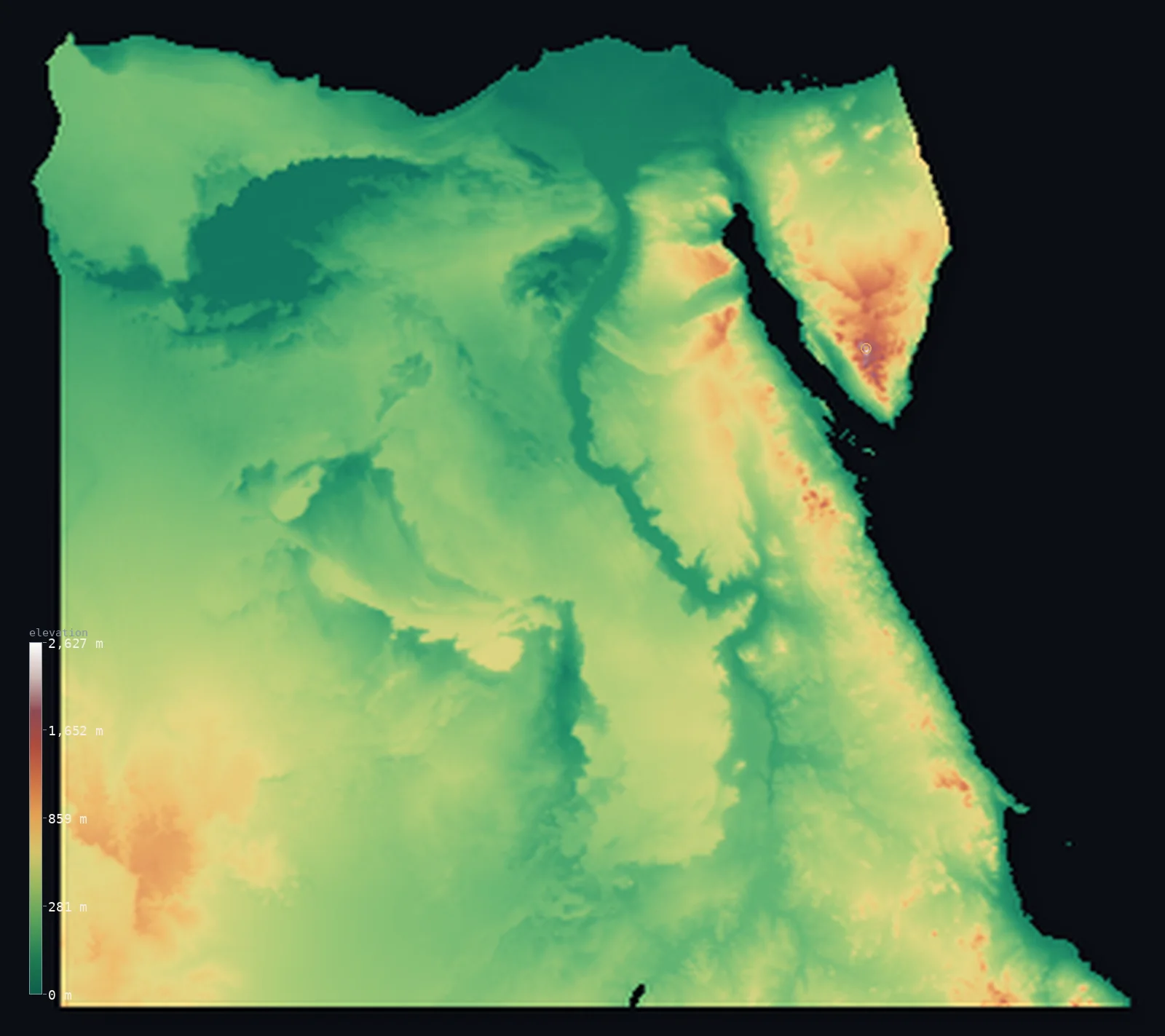
Egypt’s highest point is Mount Catherine (Gebel Katherina) at 8,625 ft (2,629 m); its lowest is Qattara Depression at −436 ft (−133 m); the mean elevation is 988 ft (301 m).
Egypt is desert with a river through it. Almost the entire country is arid plateau and sand — only about 1% of it rises above 3,281 ft (1,000 m) — and the one thread of green, the Nile valley and its delta, holds nearly the whole population on a few percent of the land. In the west the ground drops to the Qattara Depression, 436 ft (133 m) below sea level; in the east, Sinai rises to Mount Catherine at 8,625 ft (2,629 m).
- Highest point📚
- 8,625 ft2,629 m
- Egypt's highest point is Mount Catherine at 8,625 ft (2,629 m), in the granite mountains of southern Sinai — a rugged massif entirely separate from the Nile and the deserts, and the highest ground for hundreds of kilometres in any direction.
- Lowest point📚
- −436 ft−133 m
- Egypt's lowest point is the Qattara Depression at 436 ft (133 m) below sea level — a vast sunken basin of salt marsh and sand in the Western Desert, one of the largest below-sea depressions on Earth and almost entirely uninhabited.
- Mean elevation⚙
- 988 ft301 m
- Egypt's mean elevation computed from the GLO-30 model is 988 ft (301 m) — a low, flat average that describes the country well: this is a land of desert plateaus and shallow basins, with real relief only in Sinai and along the Red Sea.
- Median elevation⚙
- 846 ft258 m
- Half of Egypt lies below 846 ft (258 m), close to the mean — the mark of a broadly uniform desert surface rather than a country of highs and lows, interrupted only by the Nile's trench and the Qattara's hollow.
- Elevation range📚
- 9,062 ft2,762 m
- From the floor of the Qattara Depression to the summit of Mount Catherine, Egypt spans about 9,060 ft — but the two extremes sit at opposite ends of the country, with hundreds of kilometres of near-featureless desert between them.
- Above 1,000 m (3,281 ft)⚙
- 1%
- Only about 1% of Egypt rises above 1,000 m (3,281 ft) — essentially just the Sinai massif and the higher Red Sea Hills. The rest of the country is plateau, basin, and sand at low elevation.
- Official area📚
- 386,662 mi²1,001,450 km²
- Egypt covers about 386,662 sq mi (1,001,450 sq km) — but the habitable share is tiny: the Nile valley and delta make up a small percentage of the territory and hold almost all the population, while the rest is desert.
- Forest cover📚
- 0.1%
- Essentially none of Egypt is forested — around 0.1%, the lowest share of almost any country on Earth. Without rain, vegetation survives only where the Nile's water reaches, in the valley, the delta, and the scattered desert oases.
Highest and lowest points
Egypt's highest point is Mount Catherine (Gebel Katrina), 8,625 ft (2,629 m), in the granite massif of southern Sinai — a landscape of bare rock peaks utterly unlike the sand and plateau of the rest of the country. It stands just above neighbouring Mount Sinai, and at its foot lies Saint Catherine's Monastery, one of the oldest continuously inhabited Christian monasteries in the world.
source ↗Egypt's lowest point is the Qattara Depression, 436 ft (133 m) below sea level — an enormous sunken basin in the Western Desert, roughly the size of a small country, floored with salt marsh, sabkha, and dunes. It formed as wind stripped away the desert surface over millions of years, and it is so hostile and impassable that it anchored the southern flank of the desert battles of the Second World War: armies could not cross it.
source ↗Egypt at a glance
Egypt's lowest point, the Qattara Depression, lies 133 m below sea level - one of the largest below-sea depressions on Earth, and effectively impassable.
source ↗The Nile valley and delta make up only a small percentage of Egypt's area but hold almost the entire population - the rest of the country is desert.
source ↗Egypt's highest point, Mount Catherine (2,629 m), is in southern Sinai - a granite mountain landscape completely unlike the sandy plateaus that cover most of the country.
source ↗Only about 0.1% of Egypt is forested, among the lowest shares of any country on Earth.
source ↗The Western Desert covers around two-thirds of Egypt and contains a series of large depressions, including Qattara and the oases of Siwa, Bahariya, and Kharga.
source ↗The Red Sea Hills along Egypt's eastern coast rise sharply from the shore, separating the Nile valley from the sea.
source ↗
Elevation profile of Egypt
The largest share of land, 38%, falls in the 200–400 m band, and 85% of the territory lies below 500 m (1,640 ft).
- below 500 m (1,640 ft)85%
- 500–1,000 m14%
- 1,000–2,000 m1%
- above 2,000 m (6,562 ft)<1%
Highest peaks of Egypt
| Peak | Elevation | Range | Note |
|---|---|---|---|
| Mount Catherine (Gebel Katherina)↗ | 8,625 ft2,629 m | Sinai (Saint Catherine massif) | Highest point in Egypt, a granite summit in southern Sinai. |
| Jabal Umm Shumar↗ | 8,491 ft2,588 m | Sinai | One of the highest peaks of the southern Sinai massif, near Mount Catherine. |
| Mount Sinai (Gebel Musa)↗ | 7,497 ft2,285 m | Sinai | The traditional Mount Sinai of biblical tradition, beside Saint Catherine's Monastery. |
| Gabal Shayib al-Banat↗ | 7,175 ft2,187 m | Red Sea Hills (Eastern Desert) | The highest mountain of the Eastern Desert, in the Red Sea Hills inland from Hurghada. |
| Mount Serbal (Gebel Serbal)↗ | 6,791 ft2,070 m | Sinai | A prominent isolated peak of southern Sinai, west of Mount Catherine. |
The four Egypts
The Nile valley and delta
A narrow green trench running the length of the country, widening into a broad delta at the Mediterranean. It occupies a small fraction of Egypt's land but carries essentially all its farming and population — the river cut its valley into the desert plateau, and everything else depends on it.
The Western Desert and the Qattara Depression
Two-thirds of Egypt is the Western Desert, a vast low plateau of sand and stone dotted with oases and pocked by great depressions — the largest of them Qattara, sinking to 133 m below sea level.
The Eastern Desert and the Red Sea Hills
Between the Nile and the Red Sea lies the Eastern Desert, rising eastward into the Red Sea Hills — a rugged, dry range that climbs above 2,000 m in places and drops steeply to the coast.
Sinai
Across the Suez Canal, the Sinai Peninsula is a triangle of desert plateau in the north and granite mountains in the south, where Egypt reaches its highest ground at Mount Catherine.
How to read this map
Color shows elevation; the raised relief shows real terrain. On this map Egypt reads as broad flat desert in low browns, with the Nile's thin trench cut through it, the dark hollow of the Qattara Depression in the west, and sharper high ground only in the Red Sea Hills and southern Sinai.
The 3D relief is the actual GLO-30 elevation data, exaggerated vertically so the river's cut and the depression's hollow both show; the ×N relief slider controls how much. Tap anywhere to read that point's exact elevation.
City elevations in Egypt
Egyptian cities sit on the Nile or the coast, and nearly all of them are low — Cairo at about 80 ft where the valley opens into the delta, Alexandria at sea level on the Mediterranean. Away from the river there is almost nothing but desert.
| City | Population | Elevation |
|---|---|---|
| Cairocapitalthe capital, at the head of the Nile delta at about 25 m ↗ | 9,606,916 | 82 ft25 m |
| Alexandriaon the Mediterranean coast at sea level, at the delta's western edge ↗ | 5,263,542 | 33 ft10 m |
| Port Said | 780,515 | 23 ft7 m |
| Suez | 699,541 | 30 ft9 m |
| Assiut | 528,669 | 200 ft61 m |
| Esna | 462,787 | 289 ft88 m |
| Aswān | 379,774 | 328 ft100 m |
| Minya | 283,605 | 154 ft47 m |
| Banī Suwayf | 273,151 | 121 ft37 m |
| Hurghada | 207,132 | 26 ft8 m |
Elevation sampled at each city centre from the Copernicus GLO-30 model. Cities and population from GeoNames (CC-BY 4.0).
Egypt in comparison
Egypt's terrain rises 9,062 ft (2,762 m) from Qattara Depression, 436 ft (133 m) below sea level to Mount Catherine (Gebel Katherina) — about 31% of the height of Mount Everest, the world's highest point at 29,032 ft (8,849 m).
- Libya's mean elevation is 1,368 ft — 381 ft higher; its high point, Bikku Bitti (Bette Peak), reaches 7,438 ft (2,267 m), 1,188 ft below. Libya elevation map →
- Sudan's mean elevation is 1,736 ft — 748 ft higher; its high point, Deriba Caldera (Jebel Marra), reaches 9,980 ft (3,042 m), 1,355 ft above. Sudan elevation map →
- Israel's mean elevation is 928 ft — 59 ft lower; its high point, Mount Meron, reaches 3,963 ft (1,208 m), 4,662 ft below. Israel elevation map →
Frequently asked questions
What is the highest point in Egypt?
- Mount Catherine, 8,625 ft (2,629 m), in the granite mountains of southern Sinai.
What is the lowest point in Egypt?
- The Qattara Depression, 436 ft (133 m) below sea level - a vast sunken basin in the Western Desert and one of the largest below-sea depressions on Earth.
What is the average elevation of Egypt?
- Computed from the Copernicus GLO-30 model, the area-weighted mean is 988 ft (301 m) - low and flat, since most of the country is desert plateau.
How much of Egypt is desert?
- The overwhelming majority - the Western and Eastern Deserts and Sinai cover nearly the whole country, while the Nile valley and delta, holding almost all the population, occupy only a small fraction of the land.
What is the Qattara Depression?
- A huge below-sea-level basin in Egypt's Western Desert, reaching 133 m below sea level - wind-carved, floored with salt marsh and dunes, and effectively impassable.
Is this a topographic, relief, contour, or elevation map of Egypt?
- They describe the same thing - terrain height. This page renders the country's actual elevation surface in interactive 3D and reports the statistics computed from it.
About this map
The terrain is rendered from the Copernicus GLO-30 digital elevation model (ESA), masked to the EGY-ADM0 boundary from geoBoundaries (gbOpen). Elevation statistics are computed directly from the model; peak names and researched facts are sourced and cited. See the methodology for the full pipeline.
Our area-weighted mean, computed from the Copernicus GLO-30 model, is 988 ft (301 m); the figure commonly cited elsewhere is 1,053 ft (321 m) (CIA World Factbook). Egypt is mostly desert plateau a few hundred metres high, cut by the low Nile Valley and bordered by the below-sea-level Qattara Depression, with real mountains only in the Sinai and the Red Sea Hills, giving a moderate mean; the page reports the area-weighted figure computed from the Copernicus GLO-30 model.
Surveyed national figures: official area · forest cover · high point.
Rendered from Copernicus GLO-30 (ESA, 2021 release), boundaries from geoBoundaries. Generated 2026-06-22.
Bordering countries · 4
Egypt shares a land border with these countries — open any one to compare its terrain and highest point.