Libya Elevation Map — Topographic & 3D Terrain
Explore the terrain of Libya in interactive 3D, built from Copernicus GLO-30 satellite elevation data — a low desert plateau with almost no high ground at all. Drag to rotate, scroll to zoom, and tap any point to read its elevation.
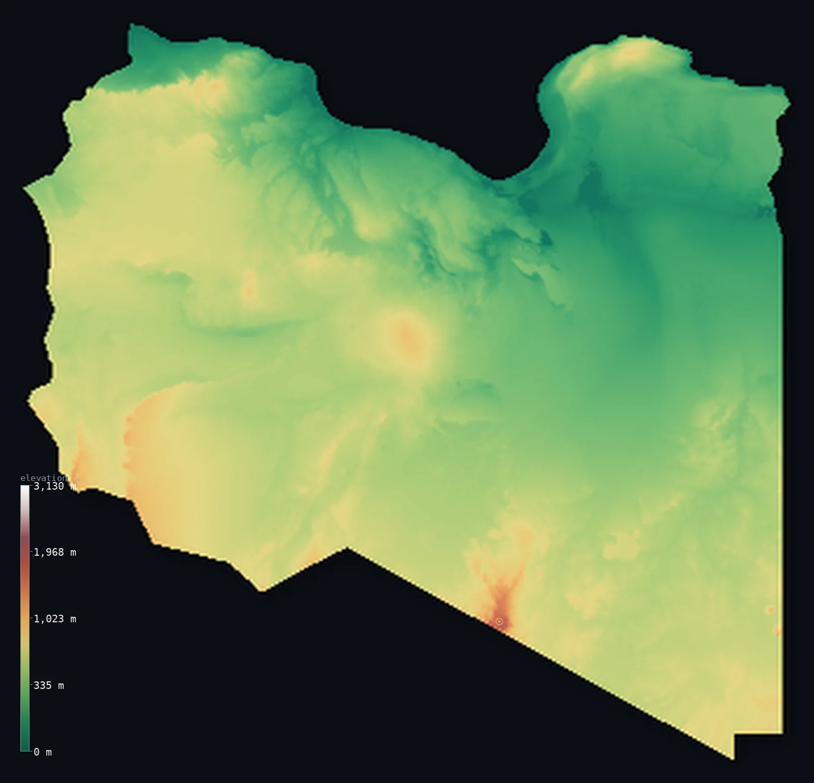
Libya’s highest point is Bikku Bitti (Bette Peak) at 7,438 ft (2,267 m); its lowest is Sabkhat Ghuzayyil at −154 ft (−47 m); the mean elevation is 1,368 ft (417 m).
Libya has a ceiling. Less than 1% of the country rises above 3,281 ft (1,000 m) — roughly twenty times less than Saudi Arabia across the Red Sea — and the land instead settles into a remarkably even desert plateau, with more than a third of it between about 400 and 600 m. Its one genuine mountain, Bikku Bitti at 7,438 ft (2,267 m), stands on the Chad border at the country's farthest southern corner, and its lowest ground, Sabkhat Ghuzayyil, lies 154 ft (47 m) below the Mediterranean.
- Highest point📚
- 7,438 ft2,267 m
- Libya's highest point is Bikku Bitti at 7,438 ft (2,267 m), on the Chad border in the Tibesti mountains — the far southern tip of the country, about 1,500 km from the coast, in terrain so remote it was among the last mountains in Africa to be surveyed.
- Lowest point📚
- −154 ft−47 m
- Libya's lowest point is Sabkhat Ghuzayyil at 154 ft (47 m) below sea level — a salt flat in the northern desert, and the deepest below-sea ground of any country in the central Sahara.
- Mean elevation⚙
- 1,368 ft417 m
- Libya's mean elevation computed from the GLO-30 model is 1,368 ft (417 m) — low for a Saharan country, and a fair reflection of terrain that is plateau rather than mountain: there is very little high ground anywhere to lift it.
- Median elevation⚙
- 1,506 ft459 m
- Half of Libya lies above 1,506 ft (459 m) — higher than the mean, which is unusual and diagnostic: the country has no great heights to pull the average up, but it does have below-sea depressions and low coastal ground pulling it down.
- Elevation range📚
- 7,592 ft2,314 m
- From Sabkhat Ghuzayyil to the summit of Bikku Bitti, Libya spans about 7,590 ft — but the two extremes lie at opposite ends of the country, and almost everything between them sits within a few hundred feet of the same plateau level.
- Above 1,000 m (3,281 ft)⚙
- 1%
- Under 1% of Libya rises above 1,000 m (3,281 ft) — a strikingly flat ceiling for a country this large. Only the Tibesti foothills in the far south and a few interior massifs reach that height at all.
- Official area📚
- 679,362 mi²1,759,540 km²
- Libya covers about 680,000 sq mi (1,759,540 sq km) — the fourth-largest country in Africa, and among the most thoroughly desert: the Sahara reaches almost to the Mediterranean shore.
- Forest cover📚
- 0.1%
- About 0.1% of Libya is forested — almost all of it on the Jabal al-Akhdar, the Green Mountain of the northeast, where the coast catches enough rain to support woodland.
Highest and lowest points
Libya's highest point is Bikku Bitti, 7,438 ft (2,267 m), at the country's extreme southern tip on the border with Chad, in the northern reaches of the Tibesti massif. It is one of the most inaccessible mountains in Africa — remote, unroaded, and long uncertainly mapped. On this elevation model the terrain in that corner reads higher than the headline figure, but the higher ground belongs to the Tibesti crest on the Chad side of the border; the figure above is Libya's own summit.
source ↗Libya's lowest point is Sabkhat Ghuzayyil, 154 ft (47 m) below sea level — a salt flat in the northern desert south of the Gulf of Sidra. Sabkhas like it form where the water table reaches the surface in a closed basin and evaporates, leaving salt crust behind. It is the deepest below-sea ground in the central Sahara, and it sits only a few hundred kilometres from a Mediterranean coast that never drains into it.
source ↗Libya at a glance
Less than 1% of Libya rises above 1,000 m - one of the flattest ceilings of any large country in Africa.
source ↗Libya's highest point, Bikku Bitti (2,267 m), sits at the country's extreme southern tip on the Chad border, about 1,500 km from the Mediterranean coast.
source ↗Sabkhat Ghuzayyil lies about 47 m below sea level - the deepest below-sea ground in the central Sahara.
source ↗The Jabal al-Akhdar, the Green Mountain of northeastern Libya, catches enough Mediterranean rain to support forest in a country that is otherwise almost entirely desert.
source ↗The Sahara reaches nearly to Libya's coastline - the habitable strip along the Mediterranean is narrow, and almost the whole population lives on it.
source ↗Libya has no permanent rivers; its water comes from underground aquifers, including the fossil water pumped north through the Great Man-Made River project.
source ↗The Fezzan sand seas of southwestern Libya hold dunes hundreds of metres high, shifting slowly with the wind.
source ↗
Elevation profile of Libya
The largest share of land, 38%, falls in the 400–600 m band, and 58% of the territory lies below 500 m (1,640 ft).
- below 500 m (1,640 ft)58%
- 500–1,000 m41%
- 1,000–2,000 m1%
- above 2,000 m (6,562 ft)<1%
Highest peaks of Libya
| Peak | Elevation | Range | Note |
|---|---|---|---|
| Bikku Bitti (Bette Peak)↗ | 7,438 ft2,267 m | Tibesti Massif (Chad border, far south) | Highest point of Libya, a peak of the volcanic Tibesti on the Chadian border in the empty far south. |
| Al-Haruj al-Aswad (Qarat as-Sab'ah)↗ | 3,901 ft1,189 m | Al-Haruj basalt field (central) | The high point of a vast basaltic volcanic field in the centre of the country. |
| Jabal al-Akhdar (Green Mountain)↗ | 2,887 ft880 m | Cyrenaica (northeast) | A green, wetter limestone upland rising behind the northeastern coast - unusually vegetated for Libya. |
A coastal strip and a level desert
The Mediterranean coast and the Jabal al-Akhdar
A thin habitable strip runs along the sea, widening in the northeast into the Jabal al-Akhdar — the Green Mountain — a limestone upland that catches enough rain for forest and farming. Almost the entire Libyan population lives on this coastal fringe.
The northern plateaus and sabkhas
Behind the coast the land rises gently onto dry plateaus, broken by closed basins where salt flats form. Sabkhat Ghuzayyil, the country's lowest point, lies in one of them, below the level of a sea it never reaches.
The Sahara
The overwhelming bulk of Libya is desert — stone plateaus, gravel plains, and the great sand seas of Murzuq and Calanshio, stretching south for a thousand kilometres at a remarkably even elevation. It is this vast, level middle that gives the country its flat statistical profile.
The southern massifs and the Tibesti
At the far southern edge the ground finally lifts — the Tibesti massif, shared with Chad, whose northern slopes carry Bikku Bitti, Libya's only true mountain and its most remote terrain.
How to read this map
Color shows elevation; the raised relief shows real terrain. On this map Libya reads as an almost uniform desert surface — broad, even, and pale — with a thin band of colour along the northern coast and a single knot of higher ground at the extreme southern tip.
The 3D relief is the actual GLO-30 elevation data, exaggerated vertically so that a country this level shows any shape at all; the ×N relief slider controls how much. Tap anywhere to read that point's exact elevation.
City elevations in Libya
Libyan cities are coastal without exception - Tripoli and Benghazi both on the Mediterranean, at either end of the habitable strip. Inland, the desert holds only oasis towns, and the country's population is pressed against the sea.
| City | Population | Elevation |
|---|---|---|
| Tripolicapitalthe capital, on the Mediterranean coast in the northwest ↗ | 1,302,947 | 49 ft15 m |
| Benghazion the northeastern coast, below the Jabal al-Akhdar ↗ | 757,490 | 16 ft5 m |
| Misratah | 355,657 | 23 ft7 m |
| Sabha | 149,329 | 1,385 ft422 m |
| Tobruk | 141,499 | 75 ft23 m |
| Ajdabiya | 131,773 | 7 ft2 m |
| Al Bayḑā’ | 129,439 | 2,044 ft623 m |
| Sirte | 106,705 | 49 ft15 m |
| At Tāj | 46,050 | 1,243 ft379 m |
| Bani Walid | 45,734 | 879 ft268 m |
Elevation sampled at each city centre from the Copernicus GLO-30 model. Cities and population from GeoNames (CC-BY 4.0).
Libya in comparison
Libya's terrain rises 7,592 ft (2,314 m) from Sabkhat Ghuzayyil, 154 ft (47 m) below sea level to Bikku Bitti (Bette Peak) — about 26% of the height of Mount Everest, the world's highest point at 29,032 ft (8,849 m).
- Egypt's mean elevation is 988 ft — 381 ft lower; its high point, Mount Catherine (Gebel Katherina), reaches 8,625 ft (2,629 m), 1,188 ft above. Egypt elevation map →
- Algeria's mean elevation is 1,827 ft — 459 ft higher; its high point, Mount Tahat, reaches 9,541 ft (2,908 m), 2,103 ft above. Algeria elevation map →
- Chad's mean elevation is 1,696 ft — 328 ft higher; its high point, Emi Koussi, reaches 11,204 ft (3,415 m), 3,766 ft above. Chad elevation map →
Frequently asked questions
What is the highest point in Libya?
- Bikku Bitti, 7,438 ft (2,267 m), on the Chad border at the country's extreme southern tip, in the Tibesti massif.
What is the lowest point in Libya?
- Sabkhat Ghuzayyil, about 154 ft (47 m) below sea level - a salt flat in the northern desert.
What is the average elevation of Libya?
- Computed from the Copernicus GLO-30 model, the area-weighted mean is 1,368 ft (417 m) - low, because the country is an even desert plateau with almost no high ground.
How mountainous is Libya?
- Barely at all - under 1% of the country rises above 1,000 m, and its only genuine mountain, Bikku Bitti, sits at the far southern border.
Does Libya have any rivers?
- No permanent ones. Water comes from underground aquifers, including fossil water piped north through the Great Man-Made River project.
Is this a topographic, relief, contour, or elevation map of Libya?
- They describe the same thing - terrain height. This page renders the country's actual elevation surface in interactive 3D and reports the statistics computed from it.
About this map
The terrain is rendered from the Copernicus GLO-30 digital elevation model (ESA), masked to the LBY-ADM0 boundary from geoBoundaries (gbOpen). Elevation statistics are computed directly from the model; peak names and researched facts are sourced and cited. See the methodology for the full pipeline.
Our area-weighted mean, computed from the Copernicus GLO-30 model, is 1,368 ft (417 m); the figure commonly cited elsewhere is 1,388 ft (423 m) (CIA World Factbook). Libya is more than 90% desert - barren plains and plateaus mostly a few hundred metres high, with real mountains only in the far south - so its mean elevation is moderate; the page reports the area-weighted figure computed from the Copernicus GLO-30 model.
Surveyed national figures: official area · forest cover · high point.
Rendered from Copernicus GLO-30 (ESA, 2021 release), boundaries from geoBoundaries. Generated 2026-06-23.
Bordering countries · 6
Libya shares a land border with these countries — open any one to compare its terrain and highest point.