Niger Elevation Map — Topographic & 3D Terrain
Explore the terrain of Niger in interactive 3D, built from Copernicus GLO-30 satellite elevation data — a vast, low, mostly Saharan country rising only in the Aïr Massif. Drag to rotate, scroll to zoom, and tap any point to read its elevation.
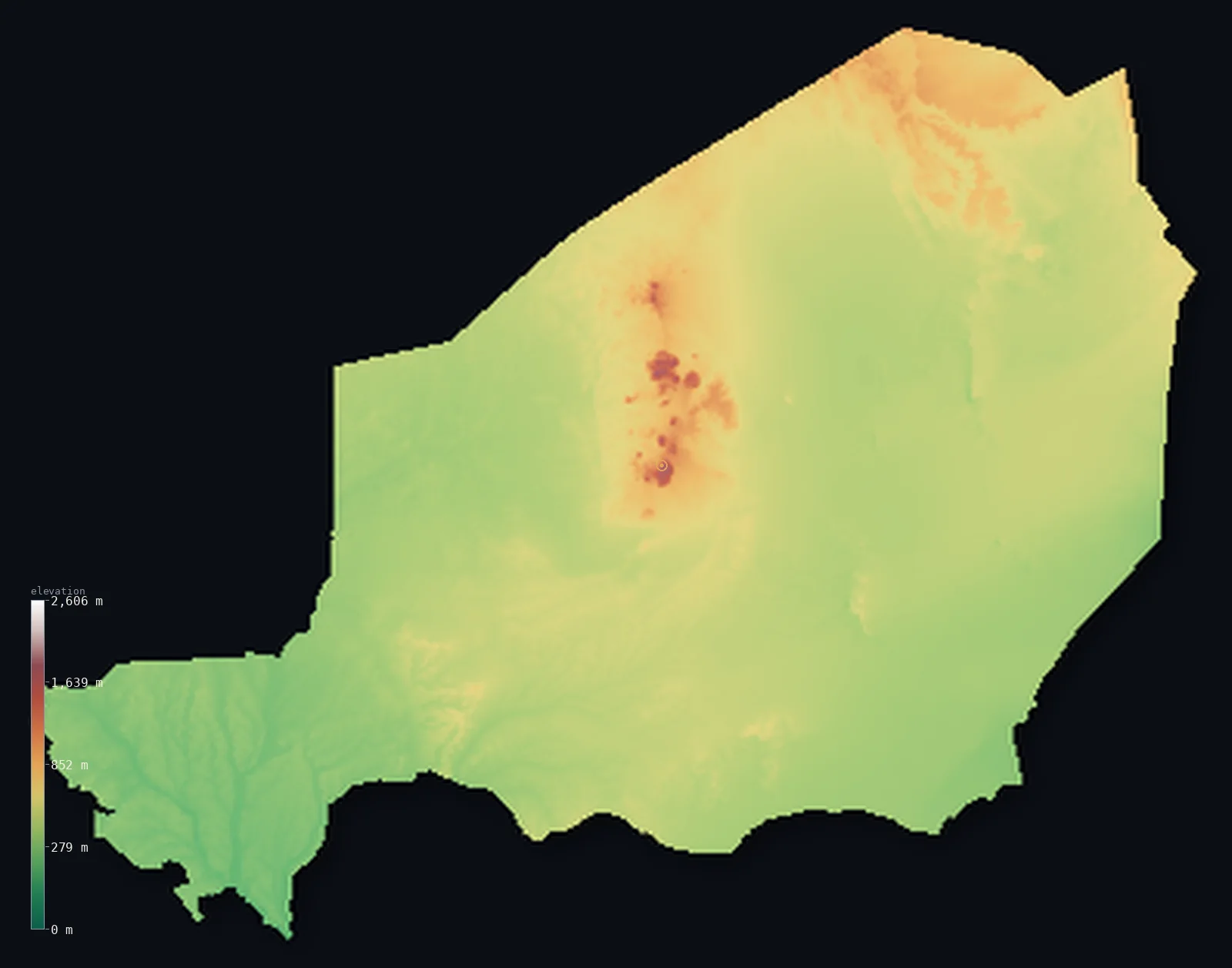
Niger’s highest point is Mont Idoukal-n-Taghes at 6,634 ft (2,022 m); its lowest is Niger River at 656 ft (200 m); the mean elevation is 1,503 ft (458 m).
Niger is a vast, landlocked country of West Africa, and more than 80% of it is Sahara Desert — the sand seas of the Ténéré and the stony plains of the north. It is a low, flat land: the desert north and the semi-arid Sahel of the south both lie low and even, and the one real upland is the Aïr Massif, a triangular granite range rising like a green island from the desert near Agadez, holding the highest point, Mont Idoukal-n-Taghès, at 6,634 ft (2,022 m). Half of Niger lies below about 1,420 ft, and less than 1% reaches 1,000 m. Almost all its people live in the far south, in the Sahel and along the Niger River, the country's one great river.
- Highest point📚
- 6,634 ft2,022 m
- Niger's highest point is Mont Idoukal-n-Taghès at 6,634 ft (2,022 m), a flat-topped granite summit on the Bagzane plateau in the Aïr Massif, deep in the Saharan interior near Agadez. The Aïr is a triangular range rising like an island from the surrounding desert — high enough to catch rain — and Idoukal-n-Taghès is the highest of its peaks. It was only confirmed as Niger's highest point around 2001, edging out Mont Gréboun farther north.
- Lowest point📚
- 656 ft200 m
- Niger's lowest point is the Niger River where it leaves the country in the far southwest, at about 656 ft (200 m). Landlocked and mostly desert, Niger is drained by just one great river, the Niger, which only clips its southwestern corner around Niamey; its lowest ground is where that river flows on toward Nigeria.
- Mean elevation⚙
- 1,503 ft458 m
- Computed from the GLO-30 model, Niger's mean elevation is 1,503 ft (458 m) — a low figure, for Niger is mostly flat desert and semi-arid plain: the sand seas and stony plains of the Sahara across the north and the Sahel belt of the south sit low and even, with the Aïr Massif the one real upland. About half the country lies below about 1,424 ft (434 m).
- Median elevation⚙
- 1,424 ft434 m
- Half of Niger lies below about 1,424 ft (434 m) — a low figure close to the mean, because most of the country is flat: the Saharan sand seas and stony plains of the north and the semi-arid Sahel of the south lie low and even. Only the Aïr Massif in the north-centre rises well above, a small granite island in a vast level land.
- Elevation range📚
- 5,978 ft1,822 m
- From the Niger River in the southwest at 200 m to Mont Idoukal-n-Taghès in the Aïr at 2,022 m, Niger's terrain spans about 5,980 ft — but the rise is confined to the Aïr Massif: most of Niger is flat desert and Sahel, and less than 1% of it stands above 1,000 m.
- Above 1,000 m (3,281 ft)⚙
- 1%
- Less than 1% of Niger rises above 1,000 m (3,281 ft) — only the Aïr Massif in the north-centre, holding Idoukal-n-Taghès and Mont Tamgak. All the rest — the Sahara of the north and the Sahel of the south — lies well below.
- Official area📚
- 489,191 mi²1,267,000 km²
- Niger covers about 489,191 sq mi (1,267,000 sq km) — a vast, landlocked West African country, more than 80% of it Sahara Desert: the sand seas and stony plains of the north, the granite Aïr Massif rising from them near Agadez, and the semi-arid Sahel of the south, where the Niger River clips the far southwestern corner around Niamey.
- Forest cover📚
- 0.9%
- About 1% of Niger is forested — a desert and semi-arid country of sand, rock, and thin Sahelian savanna, with wooded galleries only along the Niger River in the southwest and, remarkably, pockets of relict vegetation on the rain-catching heights of the Aïr.
Highest and lowest points
The highest point of Niger at 2,022 m - Mont Idoukal-n-Taghes (also Mont Bagzane), a flat-topped granite summit at the north end of the Bagzane plateau in the Air Massif, deep in the Saharan interior. It was only confirmed as the country's high point around 2001; Mont Greboun, farther north, had earlier been thought highest.
source ↗Niger's lowest point is the Niger River where it leaves the country in the far southwest, at about 200 m. Landlocked in the heart of the Sahara and Sahel, Niger is drained by just one great river — the Niger — which only clips its southwestern corner, passing the capital Niamey before flowing on into Nigeria. More than 80% of the country is desert: the sand seas of the Ténéré and the Erg of Bilma, the stony plains of the north, and, rising from them near Agadez, the Aïr Massif — a triangular granite range high enough to catch rain, an ecological 'island' holding Niger's highest peaks and plants and animals found nowhere else in the country. South of the desert lies the semi-arid Sahel, a belt of savanna where almost all Nigeriens live. So Niger is a low, flat, dry land, its relief gathered in the one desert massif and its life gathered in the far south.
source ↗Niger at a glance
Niger's high point, Mont Idoukal-n-Taghes (2,022 m), was only confirmed as the country's highest around 2001 - Mont Greboun farther north had long been assumed to be taller.
source ↗The Air Massif is an 'island' of green in the Sahara - high enough to catch rain, it shelters plants and animals found nowhere else in Niger.
source ↗More than 80% of Niger lies within the Sahara Desert, including the vast, near-empty Tenere sand sea.
source ↗Despite its size, Niger has just one major river - the Niger - which only clips its far southwestern corner.
source ↗The Air and Tenere Natural Reserve around the massif is one of the largest protected areas in Africa.
source ↗Niger's share of Lake Chad has all but vanished as the lake has shrunk dramatically since the 1960s.
source ↗
Elevation profile of Niger
The largest share of land, 52%, falls in the 400–600 m band, and 74% of the territory lies below 500 m (1,640 ft).
- below 500 m (1,640 ft)74%
- 500–1,000 m25%
- 1,000–2,000 m1%
Highest peaks of Niger
| Peak | Elevation | Range | Note |
|---|---|---|---|
| Mont Idoukal-n-Taghes↗ | 6,634 ft2,022 m | Air Massif (Bagzane plateau) | Highest point of Niger, a granite summit on the Bagzane plateau in the central Air. |
| Mont Tamgak↗ | 6,522 ft1,988 m | Air Massif (north-central) | One of the highest massifs of the Air, rising from the desert plateau. |
| Mont Greboun↗ | 6,378 ft1,944 m | Air Massif (far north) | A northern Air summit long believed to be Niger's highest before Idoukal-n-Taghes was confirmed. |
Niger: the Sahara, the Aïr Massif, and the southern Sahel
The Sahara
The desert north and east covering most of the country — the sand seas of the Ténéré and the Erg of Bilma, and the stony plains beyond. Vast, low, and near-empty.
The Aïr Massif
A triangular granite massif rising from the desert in the north-centre near Agadez — an 'island' of higher, rain-catching ground with oases and the country's highest peaks (Mont Idoukal-n-Taghès), sheltering life found nowhere else in Niger.
The Sahel and the Niger valley
The semi-arid southern belt of savanna where almost all Nigeriens live, and the Niger River valley in the far southwest around the capital, Niamey — the country's low, watered, populous edge.
How to read this map
Color shows elevation; the raised relief shows real terrain. On this map Niger reads as a vast, low, flat land — the broad even tone of the Sahara across the north and the Sahel across the south, broken only by the browns of the Aïr Massif rising as an isolated triangle in the north-centre (highest at Mont Idoukal-n-Taghès).
Because the country is largely flat, the 3D exaggeration is what makes the Aïr stand out from the desert; the ×N relief slider controls how much. Tap anywhere to read that point's exact elevation.
City elevations in Niger
Niger's people and towns cluster in the far south — Niamey, the capital, on the Niger River in the southwest, with Maradi and Zinder in the Sahel belt and Tahoua and Dosso between — while the vast desert north holds only Agadez, the gateway to the Aïr, and the uranium town of Arlit.
| City | Population | Elevation |
|---|---|---|
| Niameycapitalthe capital, on the Niger River in the far southwest ↗ | 1,323,691 | 663 ft202 m |
| Maradiin the south, in the Sahel ↗ | 361,702 | 1,171 ft357 m |
| Zinderin the south-centre, in the Sahel ↗ | 318,874 | 1,503 ft458 m |
| Tahouain the southwest-central Sahel ↗ | 159,468 | 1,266 ft386 m |
| Agadezin the north-centre, the gateway to the Aïr Massif ↗ | 149,549 | 1,647 ft502 m |
| Arlitin the north, a uranium-mining town near the Aïr ↗ | 106,448 | 1,375 ft419 m |
| Birni N Konni | 85,494 | 883 ft269 m |
| Dossoin the southwest ↗ | 79,406 | 715 ft218 m |
| Gaya | 61,533 | 571 ft174 m |
| Diffain the far southeast, toward Lake Chad ↗ | 54,082 | 1,004 ft306 m |
Elevation sampled at each city centre from the Copernicus GLO-30 model. Cities and population from GeoNames (CC-BY 4.0).
Niger in comparison
Niger's terrain rises 5,978 ft (1,822 m) from Niger River (656 ft (200 m)) to Mont Idoukal-n-Taghes — about 21% of the height of Mount Everest, the world's highest point at 29,032 ft (8,849 m).
- Mali's mean elevation is 1,043 ft — 459 ft lower; its high point, Hombori Tondo, reaches 3,789 ft (1,155 m), 2,844 ft below. Mali elevation map →
- Chad's mean elevation is 1,696 ft — 194 ft higher; its high point, Emi Koussi, reaches 11,204 ft (3,415 m), 4,570 ft above. Chad elevation map →
- Nigeria's mean elevation is 1,073 ft — 430 ft lower; its high point, Chappal Waddi, reaches 7,936 ft (2,419 m), 1,302 ft above. Nigeria elevation map →
Frequently asked questions
What is the highest point in Niger?
- Mont Idoukal-n-Taghès, 6,634 ft (2,022 m), on the Bagzane plateau in the Aïr Massif of the Saharan interior - the highest of the Aïr's granite peaks.
What is the average elevation of Niger?
- Computed from the Copernicus GLO-30 model, the area-weighted mean is 1,503 ft (458 m) - low, because more than 80% of Niger is flat Sahara and Sahel. About half the country lies below about 1,424 ft (434 m), with the Aïr Massif the one real upland.
What is the lowest point in Niger?
- The Niger River where it leaves the country in the far southwest, at about 656 ft (200 m) - the only major river, which clips the southwestern corner near Niamey.
What is the Aïr Massif?
- A triangular granite mountain range rising from the Sahara in north-central Niger, near Agadez - it holds the country's highest peaks and, high enough to catch rain, forms a green ecological island in the desert.
How much of Niger is desert?
- More than 80% - Niger lies largely within the Sahara, including the vast, near-empty Ténéré sand sea; the Aïr Massif and the southern Sahel are the exceptions.
Is this a topographic, relief, contour, or elevation map of Niger?
- They describe the same thing - terrain height. This page renders Niger's actual elevation surface in interactive 3D and reports the statistics computed from it.
About this map
The terrain is rendered from the Copernicus GLO-30 digital elevation model (ESA), masked to the NER-ADM0 boundary from geoBoundaries (gbOpen). Elevation statistics are computed directly from the model; peak names and researched facts are sourced and cited. See the methodology for the full pipeline.
Our area-weighted mean, computed from the Copernicus GLO-30 model, is 1,503 ft (458 m); the figure commonly cited elsewhere is 1,555 ft (474 m) (CIA World Factbook). Niger is a vast, low, mostly desert country — more than 80% of it within the Sahara, from the sand seas of the Ténéré to the stony plains of the north. It is remarkably flat: the Saharan north and the Sahelian south both lie low and even, and the one real upland is the Aïr Massif, a triangular granite range rising like a green island from the desert near Agadez, holding the country's highest peaks. So the mean and median are close and both low; half of Niger lies below about 1,424 ft (434 m), and less than a hundredth of it reaches 1,000 m. Almost all its people live in the far south, in the Sahel and along the Niger River, the country's one great watercourse, which only clips its southwestern corner.
Surveyed national figures: official area · forest cover · high point.
Rendered from Copernicus GLO-30 (ESA, 2021 release), boundaries from geoBoundaries. Generated 2026-06-25.
Bordering countries · 7
Niger shares a land border with these countries — open any one to compare its terrain and highest point.