Nigeria Elevation Map — Topographic & 3D Terrain
Explore the terrain of Nigeria in interactive 3D, built from Copernicus GLO-30 satellite elevation data — high plains drained by two great rivers, with mountains only along the eastern border. Drag to rotate, scroll to zoom, and tap any point to read its elevation.
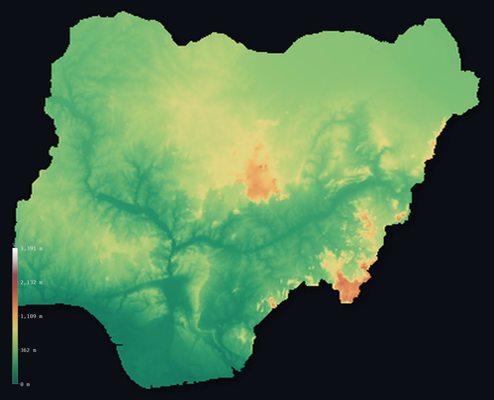
Nigeria’s highest point is Chappal Waddi at 7,936 ft (2,419 m); its lowest is Atlantic Ocean (Gulf of Guinea) at 0 ft (0 m); the mean elevation is 1,073 ft (327 m).
Nigeria rises gently inland from the sea. From the swamps of the Niger Delta the land climbs through a broad belt of high plains — 42% of the country sits between 200 and 400 m — cut in two by the great Y of the Niger and Benue rivers meeting at Lokoja. Real mountains are confined to a thin strip along the eastern border with Cameroon, where Chappal Waddi reaches 7,936 ft (2,419 m) — the highest point not just in Nigeria but in all of West Africa.
- Highest point📚
- 7,936 ft2,419 m
- Nigeria's highest point is Chappal Waddi at 7,936 ft (2,419 m), in the Gotel Mountains on the Cameroon border in the southeast — the highest point in Nigeria and in the whole of West Africa, remote enough that it went largely unrecorded until recent decades.
- Lowest point📚
- 0 ft0 m
- Nigeria's lowest point is the Gulf of Guinea at sea level, along the coast of the Niger Delta — a vast waterlogged plain of creeks, mangrove and sandbar where the country's great rivers finally reach the Atlantic.
- Mean elevation⚙
- 1,073 ft327 m
- Nigeria's mean elevation computed from the GLO-30 model is 1,073 ft (327 m) — a moderate figure that reflects the country well: most of Nigeria is neither low coast nor true mountain but a broad belt of high plains a few hundred metres above the sea.
- Median elevation⚙
- 994 ft303 m
- Half of Nigeria lies below 994 ft (303 m) — just under the mean, the mark of a country without extremes: a wide, even expanse of plateau and plain, with only a thin eastern mountain fringe and the low delta pulling the distribution in either direction.
- Elevation range📚
- 7,936 ft2,419 m
- From the Gulf of Guinea to the summit of Chappal Waddi, Nigeria spans about 7,940 ft — but the climb is gradual across most of the country, with the only abrupt height at the eastern border where the land lifts into the Cameroon highlands.
- Above 1,000 m (3,281 ft)⚙
- 2%
- Only about 2% of Nigeria rises above 1,000 m (3,281 ft) — the Jos Plateau in the centre and the eastern border highlands. But more than two-thirds of the country stands above 200 m, the mark of a broadly raised interior rather than a low one.
- Official area📚
- 356,669 mi²923,768 km²
- Nigeria covers about 356,700 sq mi (923,768 sq km) — from the mangrove coast of the Niger Delta north to the edge of the Sahel, drained throughout by the Niger and Benue rivers.
- Forest cover📚
- 7.7%
- About 7.7% of Nigeria is forested — rainforest along the southern coast and the wetter middle belt, thinning northward into savanna and, at the country's northern edge, toward the dry Sahel.
Highest and lowest points
Nigeria's highest point is Chappal Waddi, 7,936 ft (2,419 m), in the Gotel Mountains of Taraba State on the border with Cameroon — the highest peak in Nigeria and in all of West Africa. Its local name, Gangirwal, means 'Mountain of Death,' though the ascent is a steep walk rather than a technical climb. It stands in one of the remotest corners of the country, within the Gashaka-Gumti National Park, and was so little visited that its status as the region's high point was confirmed only relatively recently. The summit marks the apex of the border range; Cameroon's own higher mountains lie well to the south.
source ↗Nigeria's lowest point is the Gulf of Guinea at sea level, along the coast of the Niger Delta. The delta is one of the largest in the world — a huge fan of silt where the Niger breaks into a maze of distributaries, mangrove swamp and sandbar before reaching the Atlantic. Barely above the tide across thousands of square kilometres, it is both the wettest, most low-lying ground in the country and the source of most of Nigeria's oil and gas.
source ↗Nigeria at a glance
Chappal Waddi (2,419 m), on the Cameroon border, is the highest point not only in Nigeria but in all of West Africa.
source ↗Its local name, Gangirwal, means 'Mountain of Death' - though reaching the summit is a strenuous trek rather than a technical climb.
source ↗The Niger and Benue rivers split Nigeria into three, meeting in a great Y-shaped confluence at Lokoja in the centre of the country.
source ↗The Niger Delta is one of the largest river deltas on Earth, and holds the bulk of Nigeria's oil and gas reserves.
source ↗The Jos Plateau rises above 1,200 m in the centre of the country - a cool, temperate island of high ground in otherwise tropical Nigeria.
source ↗Nigeria's only true mountains are confined to a narrow strip along the eastern border with Cameroon; the rest of the country is plain and plateau.
source ↗
Elevation profile of Nigeria
The largest share of land, 42%, falls in the 200–400 m band, and 84% of the territory lies below 500 m (1,640 ft).
- below 500 m (1,640 ft)84%
- 500–1,000 m15%
- 1,000–2,000 m2%
- above 2,000 m (6,562 ft)<1%
Highest peaks of Nigeria
| Peak | Elevation | Range | Note |
|---|---|---|---|
| Chappal Waddi↗ | 7,936 ft2,419 m | Gotel Mountains (east, Cameroon border) | Highest point of Nigeria and West Africa, a border summit in the Adamawa Highlands. |
| Dimlang (Vogel Peak)↗ | 6,699 ft2,042 m | Shebshi Mountains (Adamawa, east) | A high summit of the Shebshi Mountains in the eastern Adamawa Highlands. |
| Shere Hills↗ | 6,001 ft1,829 m | Jos Plateau (centre) | The high ground of the Jos Plateau, an escarpment-bounded upland in central Nigeria. |
| Obudu Plateau (high ground)↗ | 5,630 ft1,716 m | Bamenda Highlands (southeast) | A cool highland plateau in the southeast on the Cameroon border. |
| Mandara Mountains (high ground)↗ | 4,902 ft1,494 m | Mandara Mountains (northeast, Cameroon border) | A volcanic upland on the northeastern border with Cameroon. |
From the delta through the high plains to the border peaks
The coastal lowlands and Niger Delta
The south is low and wet — a coast of lagoons, beaches and mangrove, dominated by the Niger Delta, where the river fans out into countless channels across a plain barely above sea level. It is the country's lowest ground and, thanks to its oil, its most economically charged.
The Niger-Benue valley and central plateaus
Through the middle of the country run the Niger and Benue, two great rivers meeting at Lokoja in a Y that divides Nigeria in three. Around and between them rise the central plateaus, most strikingly the Jos Plateau, which lifts above 1,200 m into cool, temperate highland unlike anywhere else in the country.
The northern plains and eastern highlands
North of the rivers the land opens into broad high plains that climb gently toward the Sahel, dotted with inselbergs and the Mandara Mountains along the northeastern border. To the southeast, along the Cameroon frontier, the Gotel and Shebshi mountains and the Obudu Plateau carry Nigeria's only true mountain terrain, topped by Chappal Waddi.
How to read this map
Color shows elevation; the raised relief shows real terrain. On this map Nigeria reads as a broad green-and-brown expanse rising gently from the dark low delta in the south, with the Jos Plateau standing out as a raised block in the centre and a knot of brown mountains along the eastern border.
The 3D relief is the actual GLO-30 elevation data, exaggerated vertically so the plateau and the eastern mountains both show; the ×N relief slider controls how much. Tap anywhere to read that point's exact elevation.
City elevations in Nigeria
Nigeria's cities spread across every level of the country - Lagos and Port Harcourt low on the coast, Abuja and Kaduna on the central plains, Kano and Maiduguri out on the northern plains toward the Sahel. Only the Jos Plateau's high ground has no major city on the table.
| City | Population | Elevation |
|---|---|---|
| Lagoson the southwestern coast at sea level, the largest city in Africa ↗ | 15,388,000 | 26 ft8 m |
| Kanoon the northern plains toward the Sahel, the great city of the north ↗ | 4,910,000 | 1,572 ft479 m |
| Ibadan | 3,649,000 | 594 ft181 m |
| Abujacapitalthe capital, purpose-built in the central plateau region near the country's geographic centre ↗ | 2,690,000 | 1,581 ft482 m |
| Port Harcourtin the Niger Delta near the coast, centre of the oil industry ↗ | 2,120,000 | 46 ft14 m |
| Kaduna | 1,850,000 | 2,041 ft622 m |
| Benin City | 1,782,000 | 282 ft86 m |
| Onitsha | 1,553,000 | 174 ft53 m |
| Maiduguri | 1,110,000 | 1,056 ft322 m |
| Ilorin | 1,080,000 | 1,047 ft319 m |
Elevation sampled at each city centre from the Copernicus GLO-30 model. Cities and population from GeoNames (CC-BY 4.0).
Nigeria in comparison
Nigeria's terrain rises 7,936 ft (2,419 m) from sea level to Chappal Waddi — about 27% of the height of Mount Everest, the world's highest point at 29,032 ft (8,849 m).
- Cameroon's mean elevation is 2,126 ft — 1,053 ft higher; its high point, Fako (Mount Cameroon), reaches 13,435 ft (4,095 m), 5,499 ft above. Cameroon elevation map →
- Niger's mean elevation is 1,503 ft — 430 ft higher; its high point, Mont Idoukal-n-Taghes, reaches 6,634 ft (2,022 m), 1,302 ft below. Niger elevation map →
- Benin's mean elevation is 873 ft — 200 ft lower; its high point, Mont Sokbaro, reaches 2,159 ft (658 m), 5,778 ft below. Benin elevation map →
Frequently asked questions
What is the highest point in Nigeria?
- Chappal Waddi, 7,936 ft (2,419 m), in the Gotel Mountains on the Cameroon border - the highest point in Nigeria and in all of West Africa.
What is the lowest point in Nigeria?
- The Gulf of Guinea at sea level, along the coast of the Niger Delta.
What is the average elevation of Nigeria?
- Computed from the Copernicus GLO-30 model, the area-weighted mean is 1,073 ft (327 m) - moderate, because most of the country is high plains a few hundred metres above the sea.
What is the Jos Plateau?
- A raised block of high ground above 1,200 m in the centre of Nigeria, cool and temperate enough to stand apart from the tropical country around it.
How do the Niger and Benue rivers shape Nigeria?
- They divide the country into three, meeting in a Y-shaped confluence at Lokoja - the Niger flowing in from the northwest, the Benue from the northeast, and the joined river running south to the delta.
Is this a topographic, relief, contour, or elevation map of Nigeria?
- They describe the same thing - terrain height. This page renders the country's actual elevation surface in interactive 3D and reports the statistics computed from it.
About this map
The terrain is rendered from the Copernicus GLO-30 digital elevation model (ESA), masked to the NGA-ADM0 boundary from geoBoundaries (gbOpen). Elevation statistics are computed directly from the model; peak names and researched facts are sourced and cited. See the methodology for the full pipeline.
Our area-weighted mean, computed from the Copernicus GLO-30 model, is 1,073 ft (327 m); the figure commonly cited elsewhere is 1,247 ft (380 m) (CIA World Factbook). Nigeria rises from the coastal lowlands and Niger Delta through the broad Niger-Benue valley to high plains and plateaus, with real mountains only along the eastern Cameroon border, so its mean elevation is moderate; the page reports the area-weighted figure computed from the Copernicus GLO-30 model.
Surveyed national figures: official area · forest cover · high point.
Rendered from Copernicus GLO-30 (ESA, 2021 release), boundaries from geoBoundaries. Generated 2026-06-26.
Bordering countries · 4
Nigeria shares a land border with these countries — open any one to compare its terrain and highest point.