Cameroon Elevation Map — Topographic & 3D Terrain
Explore the terrain of Cameroon in interactive 3D, built from Copernicus GLO-30 satellite elevation data — a strikingly varied country from Atlantic coast and rainforest to volcanic highlands, savanna, and the Lake Chad basin. Drag to rotate, scroll to zoom, and tap any point to read its elevation.
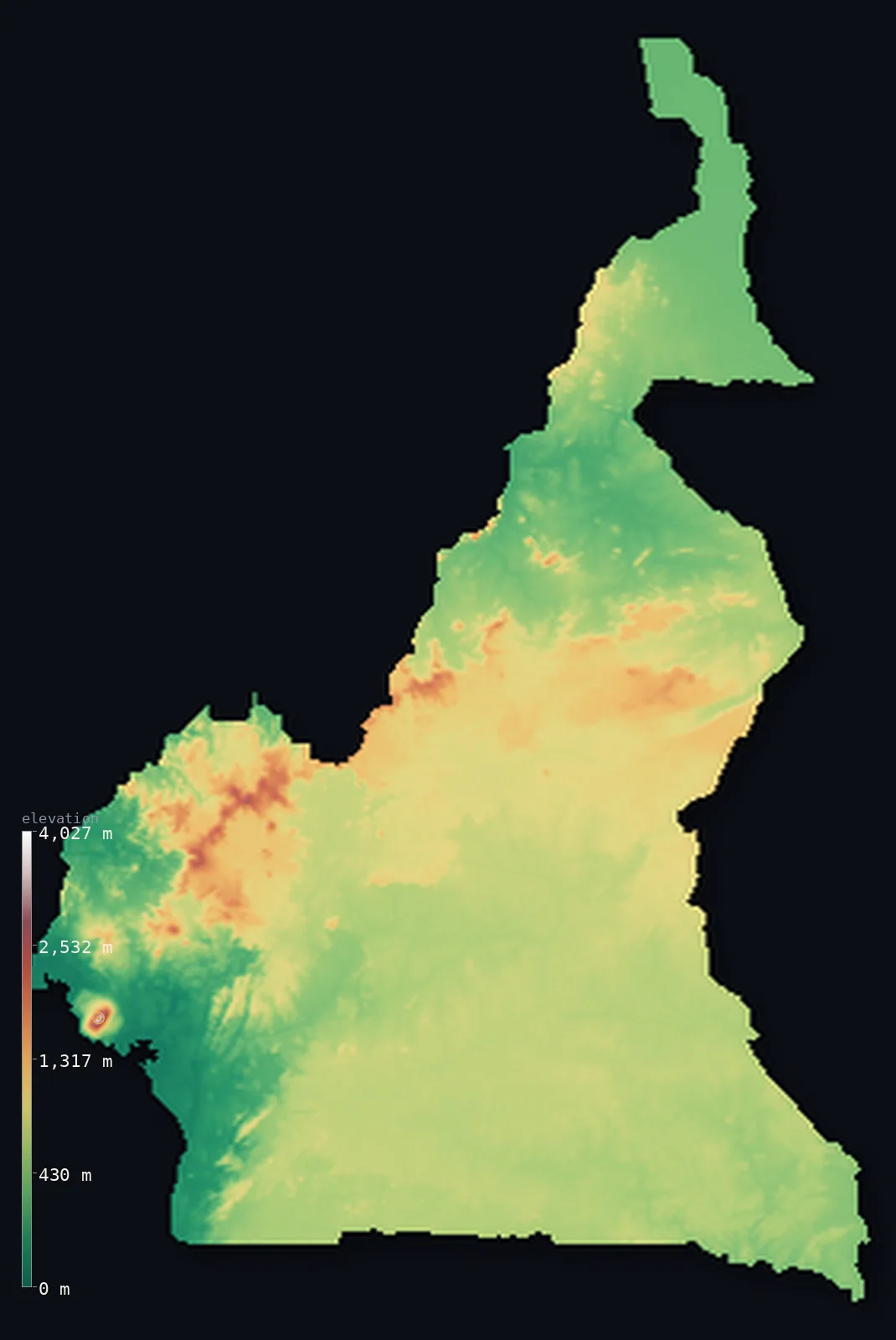
Cameroon’s highest point is Fako (Mount Cameroon) at 13,435 ft (4,095 m); its lowest is Atlantic Ocean at 0 ft (0 m); the mean elevation is 2,126 ft (648 m).
Cameroon is often called 'Africa in miniature' — and its terrain shows why. In the southwest, an Atlantic coast of mangroves and beaches gives way to dense equatorial rainforest, out of which rises Mount Cameroon, a huge active volcano reaching 13,435 ft (4,095 m), the highest of the Cameroon Volcanic Line and one of the continent's few active peaks. Northward the land climbs into the Cameroon Highlands and the grassy Western High Plateau, then the broad Adamawa Plateau across the country's waist, before descending to the northern savanna plains and, in the far north, the low basin of Lake Chad. Coast, forest, mountains, plateau, savanna, and semi-desert — nearly every African landscape in one country.
- Highest point📚
- 13,435 ft4,095 m
- Cameroon's highest point is Mount Cameroon at 13,435 ft (4,095 m), an active volcano near the Atlantic coast in the southwest — the highest of the Cameroon Volcanic Line and one of the few active volcanoes on the African continent. Known also as Fako or Mongo ma Ndemi, the 'Mountain of Greatness,' it rises straight from the coastal rainforest to a bare, cool summit, occasionally dusted with snow despite lying near the equator, and its lower slopes get some of the heaviest rainfall on Earth. It is the westernmost and greatest of the Cameroon Line, the chain of volcanoes running up through the country.
- Lowest point📚
- 0 ft0 m
- Cameroon's lowest point is the Atlantic Ocean at sea level, along the Gulf of Guinea coast in the southwest — a low, wet shore of mangroves, estuaries, and beaches, from which the land rises quickly into forest and, at Mount Cameroon, straight to the country's summit.
- Mean elevation⚙
- 2,126 ft648 m
- Computed from the GLO-30 model, Cameroon's mean elevation is 2,126 ft (648 m) — the midpoint of a country pulled between extremes: a 4,095 m active volcano and a sea-level Atlantic coast, with the high Western Highlands and the broad Adamawa Plateau on one hand and the low southern rainforest and northern Lake Chad plains on the other. No single figure captures terrain this varied.
- Median elevation⚙
- 2,116 ft645 m
- Half of Cameroon lies above about 2,116 ft (645 m) — a middling figure reflecting the country's range: the central Adamawa Plateau and the western highlands are high, the southern forest and northern plains lower, and the whole spread from sea-level coast to a 4,000 m volcano is held between.
- Elevation range📚
- 13,435 ft4,095 m
- Cameroon's terrain climbs about 13,435 ft in all, from the Atlantic to the 4,095 m summit of Mount Cameroon — but the figure undersells the variety: the climb passes through coast, rainforest, volcanic highlands, high plateau, and northern savanna, nearly every African landscape stacked from sea to summit.
- Above 1,000 m (3,281 ft)⚙
- 12%
- About 12% of Cameroon rises above 1,000 m (3,281 ft) — the Western High Plateau and Cameroon Highlands in the west, and the broad Adamawa Plateau across the country's centre. The southern forest, the coast, and the northern plains lie lower.
- Official area📚
- 183,568 mi²475,440 km²
- Cameroon covers about 183,600 sq mi (475,440 sq km) — a strikingly varied country in west-central Africa, from an Atlantic coast and southern rainforest through volcanic western highlands and the central Adamawa Plateau to northern savanna and the Lake Chad basin, crowned by Mount Cameroon, the highest of the Cameroon Volcanic Line.
- Forest cover📚
- 41.7%
- About 42% of Cameroon is forested — dense equatorial rainforest across the south (part of the Congo Basin forest), montane forest on the western highlands, giving way to wooded savanna across the centre and open savanna and semi-desert in the north.
Highest and lowest points
Cameroon's highest point is Mount Cameroon, 13,435 ft (4,095 m), an active volcano rising near the Atlantic coast in the southwest — the highest peak of the Cameroon Volcanic Line and one of only a few active volcanoes on the African continent. Known also as Fako (its highest peak) or Mongo ma Ndemi, the 'Mountain of Greatness,' it rises straight from the coastal rainforest to a bare, cold summit, sometimes dusted with snow despite sitting almost on the equator. Its seaward slopes receive some of the heaviest rainfall anywhere on Earth. Mount Cameroon is the westernmost and highest of the Cameroon Line — a chain of volcanoes and highlands running northeast through the country, including Mount Oku and the grassfields of the Western High Plateau — and it last erupted in 2012. It towers over the whole country: nothing else in Cameroon comes close.
source ↗Cameroon's lowest point is the Atlantic Ocean at sea level, along the Gulf of Guinea coast in the southwest — a low, wet shore of mangroves, river estuaries, and beaches, with the port of Douala on the Wouri estuary. This coast is one of the wettest places on Earth: the slopes of Mount Cameroon just inland catch enormous rainfall. From the coast the land rises fast — into equatorial rainforest, and at Mount Cameroon, straight up the flank of an active volcano to the country's highest point. Behind the coast and the southern forest, the land steps up through the highlands and plateaus that make up most of the country.
source ↗Cameroon at a glance
Cameroon is called 'Africa in miniature' because it packs in nearly every African landscape — coast, rainforest, savanna, highland and desert-edge Sahel — within one country.
source ↗Its highest point, Mount Cameroon (4,095 m), is an active volcano that rises straight from the Atlantic coast — one of the few active volcanoes on the continent, last erupting in 2012.
source ↗Mount Cameroon is one of the few volcanoes on Earth at an ocean–continent boundary; a 1999 lava flow stopped just 200 m short of the sea, and a 1922 flow reached the coast.
source ↗In 1986 a sudden release of carbon dioxide from crater Lake Nyos, in the Western Highlands, killed about 1,700 people — one of the rare 'limnic eruptions' known to science.
source ↗The Cameroon Volcanic Line is a 1,600 km chain of volcanoes running from islands in the Gulf of Guinea across the mainland toward Lake Chad — geologically unusual for crossing both ocean and continent.
source ↗The Adamawa Plateau forms a natural barrier across the middle of Cameroon, separating the forested, farming south from the drier, pastoral north.
source ↗Lake Chad, at Cameroon's northern tip, is the largest inland body of water in the Sahel — but is shallow (only ~7 m deep) and varies enormously in size between seasons.
source ↗
Elevation profile of Cameroon
The largest share of land, 43%, falls in the 500–750 m band, and 71% of the territory lies above 500 m (1,640 ft).
- below 500 m (1,640 ft)29%
- 500–1,000 m59%
- 1,000–2,000 m11%
- above 2,000 m (6,562 ft)<1%
Highest peaks of Cameroon
| Peak | Elevation | Range | Note |
|---|---|---|---|
| Fako (Mount Cameroon)↗ | 13,435 ft4,095 m | Cameroon Volcanic Line | Highest point of Cameroon and an active volcano rising from the Atlantic coast; one of the few active volcanoes on the continent. |
| Mount Oku↗ | 9,879 ft3,011 m | Western Highlands (Cameroon Volcanic Line) | The second-highest summit in Cameroon and the high point of the Bamenda Grassfields, a dormant volcano with a crater lake. |
| Bamboutos Mountains↗ | 8,990 ft2,740 m | Western Highlands (Cameroon Volcanic Line) | A dormant volcanic massif of the Western High Plateau, among the highest of the Cameroon Line's mainland volcanoes. |
| Mount Kupe↗ | 6,772 ft2,064 m | Western Highlands (Cameroon Volcanic Line) | A forested dormant volcano of the Western Highlands, known for its endemic birds and rich montane forest. |
| Adamawa Plateau high ground↗ | 4,921 ft1,500 m | Adamawa Plateau | The grassy, rugged Adamawa tableland (~1,000–1,500 m) that forms the barrier between Cameroon's forested south and pastoral north. |
Cameroon: the coast and southern forest, the western highlands and Adamawa Plateau, and the northern plains
The coast and southern forest
Cameroon's southwest is a low Atlantic coast of mangroves and estuaries, backed by dense equatorial rainforest — part of the great Congo Basin forest — and dominated by the active volcano Mount Cameroon, which rises straight from the coast to the country's summit. Wet, green, and low (but for the volcano), it is the country's tropical corner.
The western highlands and the Adamawa Plateau
Northward and inland the land climbs — into the volcanic Cameroon Highlands and grassy Western High Plateau of the west (Mount Oku, the grassfields), and the broad Adamawa Plateau across the country's waist, a high divide of savanna. The high, cool, fertile heart of the country.
The northern plains and Lake Chad basin
North of the Adamawa Plateau the land descends to the northern savanna plains — drier, hotter grassland cut by the Bénoué River and studded with the rugged Mandara Mountains on the Nigerian border — and, in the far north, the low basin of Lake Chad. The country's dry, low northern extremity.
How to read this map
Color shows elevation; the raised relief shows real terrain. On this map Cameroon reads as a country of striking variety — a low green coast and southern forest in the southwest (with Mount Cameroon spiking up sharply right by the sea), rising to the browns of the western highlands and the broad Adamawa Plateau across the centre, then falling north to the lower savanna plains and the flat Lake Chad basin in the far north.
The 3D relief is the actual GLO-30 elevation data, exaggerated vertically so the coast, the volcano, the plateaus, and the northern plains all show; the ×N relief slider controls how much. Tap anywhere to read that point's exact elevation.
City elevations in Cameroon
Cameroon's cities range across its landscapes — Douala, the largest, on the coast, Yaoundé, the capital, in the southern forest hills, Bamenda in the western highlands, Ngaoundéré on the central Adamawa Plateau, and Maroua in the northern savanna. Coast, forest, highland, and savanna each hold major cities.
| City | Population | Elevation |
|---|---|---|
| Doualathe largest city and main port, on the Atlantic coast ↗ | 1,338,082 | 52 ft16 m |
| Yaoundécapitalthe capital, in the southern forested hills ↗ | 1,299,369 | 2,365 ft721 m |
| Bamendain the western highlands ↗ | 420,445 | 4,104 ft1,251 m |
| Marouain the far north ↗ | 314,122 | 1,319 ft402 m |
| Ngaoundéréon the Adamawa Plateau, in the centre ↗ | 238,196 | 3,694 ft1,126 m |
| Nkongsambain the southwest, below the western highlands ↗ | 162,309 | 2,730 ft832 m |
| Bertouain the eastern rainforest ↗ | 137,993 | 2,165 ft660 m |
| Ébolowain the southern forest ↗ | 101,363 | 1,900 ft579 m |
| Kribia southern coastal town and port ↗ | 93,482 | 23 ft7 m |
Elevation sampled at each city centre from the Copernicus GLO-30 model. Cities and population from GeoNames (CC-BY 4.0).
Cameroon in comparison
Cameroon's terrain rises 13,435 ft (4,095 m) from sea level to Fako (Mount Cameroon) — about 46% of the height of Mount Everest, the world's highest point at 29,032 ft (8,849 m).
- Nigeria's mean elevation is 1,073 ft — 1,053 ft lower; its high point, Chappal Waddi, reaches 7,936 ft (2,419 m), 5,499 ft below. Nigeria elevation map →
- Chad's mean elevation is 1,696 ft — 430 ft lower; its high point, Emi Koussi, reaches 11,204 ft (3,415 m), 2,231 ft below. Chad elevation map →
- Gabon's mean elevation is 1,243 ft — 883 ft lower; its high point, Mont Bengoue, reaches 3,510 ft (1,070 m), 9,925 ft below. Gabon elevation map →
- Central African Republic's mean elevation is 1,962 ft — 164 ft lower; its high point, Mont Ngaoui, reaches 4,626 ft (1,410 m), 8,809 ft below. Central African Republic elevation map →
Frequently asked questions
What is the highest point in Cameroon?
- Mount Cameroon, 13,435 ft (4,095 m), an active volcano near the Atlantic coast — the highest of the Cameroon Volcanic Line and one of the few active volcanoes on the continent, last erupting in 2012.
What is the lowest point in Cameroon?
- The Atlantic Ocean at sea level, along the Gulf of Guinea coast in the southwest, around the port of Douala.
What is the average elevation of Cameroon?
- Computed from the Copernicus GLO-30 model, the area-weighted mean is 2,126 ft (648 m) — moderate, averaging a very varied country: low coast and forest, high western highlands and central plateau, and the northern plains down to Lake Chad.
Why is Cameroon called 'Africa in miniature'?
- Because it holds nearly every African landscape in one country — Atlantic coast, equatorial rainforest, volcanic highlands, high savanna plateau, and the semi-desert of the Lake Chad basin.
How high is Mount Cameroon?
- 13,435 ft (4,095 m) — an active volcano rising straight from the Atlantic coast, the highest of the Cameroon Volcanic Line, whose slopes catch some of the heaviest rainfall on Earth.
Is this a topographic, relief, contour, or elevation map of Cameroon?
- They describe the same thing — terrain height. This page renders the country's actual elevation surface in interactive 3D and reports the statistics computed from it.
About this map
The terrain is rendered from the Copernicus GLO-30 digital elevation model (ESA), masked to the CMR-ADM0 boundary from geoBoundaries (gbOpen). Elevation statistics are computed directly from the model; peak names and researched facts are sourced and cited. See the methodology for the full pipeline.
Our area-weighted mean, computed from the Copernicus GLO-30 model, is 2,126 ft (648 m); the figure commonly cited elsewhere is 2,188 ft (667 m) (CIA World Factbook). Cameroon climbs from the Atlantic coast through forested plateaus to the high Adamawa tableland and the volcanic Western Highlands, then falls again to northern plains, so the mean elevation is moderate; the page reports the area-weighted figure computed from the Copernicus GLO-30 model.
Surveyed national figures: official area · forest cover · high point.
Rendered from Copernicus GLO-30 (ESA, 2021 release), boundaries from geoBoundaries. Generated 2026-06-22.
Bordering countries · 6
Cameroon shares a land border with these countries — open any one to compare its terrain and highest point.