Equatorial Guinea Elevation Map — Topographic & 3D Terrain
Explore the terrain of Equatorial Guinea in interactive 3D, built from Copernicus GLO-30 satellite elevation data — a forested country of a mainland (Río Muni) and the volcanic island of Bioko, which holds the highest point. Drag to rotate, scroll to zoom, and tap any point to read its elevation.
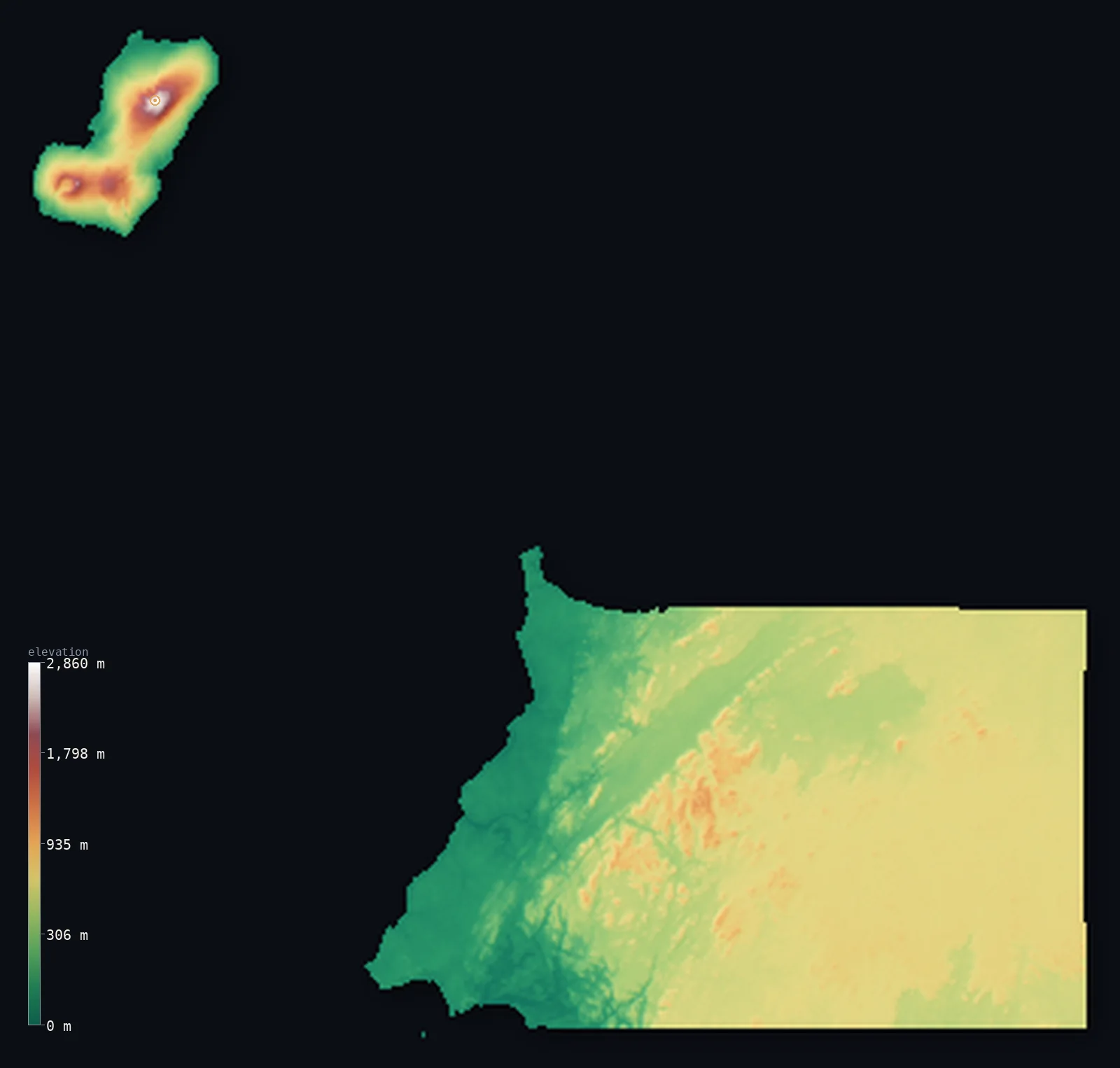
Equatorial Guinea’s highest point is Pico Basile at 9,879 ft (3,011 m); its lowest is Atlantic Ocean at 0 ft (0 m); the mean elevation is 1,604 ft (489 m).
Equatorial Guinea is a small, heavily forested country of Central Africa, split into two parts — and its highest ground is not on the mainland. The continental bulk, Río Muni, is a rainforested wedge between Cameroon and Gabon, rising from a low Atlantic coast to interior hills. Offshore, in the Gulf of Guinea, lie the volcanic islands, chief among them Bioko — part of the Cameroon volcanic line — whose shield volcano, Pico Basile, is the country's highest point at 9,879 ft (3,011 m) and holds the capital, Malabo. Because the forested hills and the island volcanoes stand high while the low ground is on the coasts, half of Equatorial Guinea lies above about 1,890 ft, higher than its mean.
- Highest point📚
- 9,879 ft3,011 m
- Equatorial Guinea's highest point is Pico Basile at 9,879 ft (3,011 m) — and, notably, it is not on the mainland but on the island of Bioko, in the Gulf of Guinea, where it is a basaltic shield volcano forming the island's northern half, close to the capital, Malabo. Bioko is part of the Cameroon volcanic line, and from Pico Basile's summit Mount Cameroon is visible to the northeast across the sea.
- Lowest point📚
- 0 ft0 m
- Equatorial Guinea's lowest point is the Atlantic Ocean at sea level, along the coasts of both its parts — the mainland (Río Muni) between Cameroon and Gabon, and the volcanic islands of the Gulf of Guinea. From the low coastal plains the land rises inland to the rainforested hills of Río Muni and, on Bioko, steeply up the volcanoes.
- Mean elevation⚙
- 1,604 ft489 m
- Computed from the GLO-30 model, Equatorial Guinea's mean elevation is 1,604 ft (489 m) — but half the country lies above about 1,886 ft (575 m), higher than the mean, because most of it stands fairly high: the rainforested hill-country of the Río Muni interior and the volcanic uplands of Bioko. The low coastal plains and the sea-level fringes pull the average down below the midpoint.
- Median elevation⚙
- 1,886 ft575 m
- Half of Equatorial Guinea lies above about 1,886 ft (575 m) — and this midpoint is higher than the mean, because much of the country is high: the forested interior hills of the mainland (Río Muni) rising to Monte Mitra, and the volcanic mass of Bioko rising to Pico Basile. It is the low coastal plains, on both the mainland and the islands, that drag the average below the median.
- Elevation range📚
- 9,879 ft3,011 m
- From the Atlantic coast to Pico Basile on Bioko at 3,011 m, Equatorial Guinea's terrain climbs about 9,879 ft — a wide range for a small country, from sea-level rainforest coast up a shield volcano, with the mainland's forested hills rising more modestly to Monte Mitra between.
- Above 1,000 m (3,281 ft)⚙
- 2%
- About 2% of Equatorial Guinea rises above 1,000 m (3,281 ft) — chiefly the volcanoes of Bioko (Pico Basile and the Gran Caldera de Luba) and the higher hills of the Río Muni interior. Most of the country — the coastal plains and lower forest — lies below.
- Official area📚
- 10,831 mi²28,051 km²
- Equatorial Guinea covers about 10,831 sq mi (28,051 sq km) — a small Central African country in two parts: the mainland (Río Muni), a rainforested wedge between Cameroon and Gabon rising from a low coast to interior hills, and the volcanic islands of the Gulf of Guinea — Bioko, holding the capital Malabo and the highest point, Pico Basile, and distant Annobón to the south.
- Forest cover📚
- 87.8%
- About 88% of Equatorial Guinea is forested — one of the most heavily forested countries in Africa: dense equatorial rainforest across the Río Muni mainland, part of the great Congo-Guinean forest belt, and montane forest on the volcanic slopes of Bioko, whose southern flanks are among the wettest places in Africa.
Highest and lowest points
The highest point of Equatorial Guinea at about 3,011 m - Pico Basile, a basaltic shield volcano that forms the northern half of Bioko island, close to the capital Malabo (CIA gives 3,008 m). Notably it is NOT on the mainland: the country's high point stands on an island, part of the Cameroon volcanic line, with Mount Cameroon visible to the northeast.
source ↗Equatorial Guinea's lowest point is the Atlantic Ocean at sea level, along the coasts of its two parts. The country is split between a mainland and a scatter of volcanic islands. The mainland, Río Muni, is a rainforested wedge between Cameroon and Gabon — low coastal plains around Bata rising inland to forested hills and Monte Mitra. Offshore, in the Gulf of Guinea, lie the islands: Bioko, about 32 km off Cameroon, formed by three overlapping shield volcanoes and holding the capital, Malabo, and the highest point, Pico Basile (3,011 m) — Bioko is part of the Cameroon volcanic line, and its southern slopes are among the wettest places in Africa. Far to the south, below the Equator, lies tiny Annobón, the country's southernmost territory, along with Corisco and the Elobey islets. Almost 90% of the country is rainforest. This map shows the mainland (Río Muni) and Bioko together; distant Annobón lies far to the southwest and is not shown in this view.
source ↗Equatorial Guinea at a glance
Equatorial Guinea's highest point isn't on its mainland - Pico Basile (3,011 m) is a volcano on the island of Bioko, which also holds the capital, Malabo.
source ↗The country is split in two: a rainforest mainland (Rio Muni) between Cameroon and Gabon, and volcanic islands in the Gulf of Guinea up to 350 km offshore.
source ↗Bioko and its volcanoes are part of the Cameroon volcanic line, and on a clear day Mount Cameroon is visible to the northeast from Pico Basile's summit.
source ↗Annobon, the country's southernmost island, is the only part of Equatorial Guinea that lies south of the Equator.
source ↗Despite the name, almost none of the country sits exactly on the Equator - the Equator passes just to the south, through the sea between the mainland and Annobon.
source ↗Bioko's southern slopes are among the wettest places in Africa, with parts of the island receiving over 10,000 mm of rain a year.
source ↗
Elevation profile of Equatorial Guinea
The largest share of land, 39%, falls in the 600–800 m band, and 58% of the territory lies above 500 m (1,640 ft).
- below 500 m (1,640 ft)42%
- 500–1,000 m56%
- 1,000–2,000 m2%
- above 2,000 m (6,562 ft)<1%
Highest peaks of Equatorial Guinea
| Peak | Elevation | Range | Note |
|---|---|---|---|
| Pico Basile↗ | 9,879 ft3,011 m | Bioko island (Cameroon volcanic line) | Highest point of Equatorial Guinea, a shield volcano forming northern Bioko. |
| Gran Caldera de Luba↗ | 7,418 ft2,261 m | Bioko island (south) | The high rim of a large caldera forming the southern volcanic massif of Bioko. |
| Monte Mitra↗ | 3,937 ft1,200 m | Crystal Mountains (mainland Rio Muni) | The highest point of the mainland, in the Crystal Mountains of the interior rainforest. |
Equatorial Guinea: Bioko island, the Río Muni mainland, and the outer islands
Bioko island
A volcanic island in the Gulf of Guinea about 32 km off Cameroon, formed by three overlapping shield volcanoes — Pico Basile (the high point) and the Gran Caldera de Luba — holding the capital, Malabo. Its southern slopes are among the wettest places in Africa.
Río Muni (the mainland)
The continental bulk of the country, between Cameroon and Gabon — low Atlantic coastal plains rising inland to a rainforested interior of hills (Monte Mitra), holding the largest city, Bata.
Annobón and the smaller islands
Distant Annobón, a tiny volcanic island far to the south — the only Equatoguinean territory below the Equator — with Corisco and the Elobey islets. (Annobón is not shown in this view.)
How to read this map
Color shows elevation; the raised relief shows real terrain. On this map Equatorial Guinea shows its two parts — the island of Bioko in the north, rising sharply in the high browns of the Pico Basile volcano, and the mainland (Río Muni) to the southeast, a broad green of rainforest rising from a low coast to interior hills.
The island volcano and the forested mainland are the two extremes; the 3D exaggeration brings both out, and the ×N relief slider controls how much. Tap anywhere to read that point's exact elevation. (Distant Annobón is not shown in this view.)
City elevations in Equatorial Guinea
Equatorial Guinea's capital, Malabo, sits on the volcanic island of Bioko, while the largest city, Bata, and most of the population are on the mainland (Río Muni), where a new capital, Ciudad de la Paz, is rising in the interior; other towns like Ebebiyín and Mongomo lie inland along the Cameroon and Gabon borders.
| City | Population | Elevation |
|---|---|---|
| Batathe largest city, on the mainland (Río Muni) coast ↗ | 173,046 | 39 ft12 m |
| Malabothe capital, on the island of Bioko below Pico Basile ↗ | 155,963 | 95 ft29 m |
| Ebebiyinin the far northeast of Río Muni, near the Cameroon and Gabon borders ↗ | 24,831 | 1,844 ft562 m |
| Aconibe | 11,192 | 2,205 ft672 m |
| Añisocin the interior of Río Muni ↗ | 10,191 | 1,499 ft457 m |
| Lubaa port on the island of Bioko ↗ | 8,655 | 161 ft49 m |
| Evinayongin the interior of Río Muni ↗ | 8,462 | 2,205 ft672 m |
| Mongomoin the east of Río Muni, near the Gabon border ↗ | 6,393 | 2,080 ft634 m |
| Mikomeseng | 5,813 | 1,755 ft535 m |
| Ciudad de la Pazcapitala new capital rising in the Río Muni interior ↗ | 2,000 | 2,080 ft634 m |
Elevation sampled at each city centre from the Copernicus GLO-30 model. Cities and population from GeoNames (CC-BY 4.0).
Equatorial Guinea in comparison
Equatorial Guinea's terrain rises 9,879 ft (3,011 m) from sea level to Pico Basile — about 34% of the height of Mount Everest, the world's highest point at 29,032 ft (8,849 m).
- Gabon's mean elevation is 1,243 ft — 361 ft lower; its high point, Mont Bengoue, reaches 3,510 ft (1,070 m), 6,368 ft below. Gabon elevation map →
- Cameroon's mean elevation is 2,126 ft — 522 ft higher; its high point, Fako (Mount Cameroon), reaches 13,435 ft (4,095 m), 3,556 ft above. Cameroon elevation map →
- Sao Tome and Principe's mean elevation is 1,145 ft — 459 ft lower; its high point, Pico de Sao Tome, reaches 6,640 ft (2,024 m), 3,238 ft below. Sao Tome and Principe elevation map →
Frequently asked questions
What is the highest point in Equatorial Guinea?
- Pico Basile, 9,879 ft (3,011 m), a shield volcano on the island of Bioko - not on the mainland. It forms the northern half of Bioko, close to the capital, Malabo.
Is Equatorial Guinea's highest point on the mainland?
- No - Pico Basile (3,011 m) is a volcano on the island of Bioko, in the Gulf of Guinea. The mainland (Río Muni) rises only to the forested hills of Monte Mitra.
What is the average elevation of Equatorial Guinea?
- No standard source publishes one, so this page reports the mean computed from the Copernicus GLO-30 model, 1,604 ft (489 m). Half the country lies above about 1,886 ft (575 m), higher than the mean, which the low coasts pull down.
What are the parts of Equatorial Guinea?
- A mainland, Río Muni, wedged between Cameroon and Gabon, and volcanic islands in the Gulf of Guinea - chiefly Bioko (with the capital Malabo and the high point Pico Basile) and distant Annobón to the south.
Where is the capital, Malabo?
- On the island of Bioko, in the Gulf of Guinea, at the foot of the Pico Basile volcano - not on the mainland, where the largest city, Bata, lies.
Is this a topographic, relief, contour, or elevation map of Equatorial Guinea?
- They describe the same thing - terrain height. This page renders the country's actual elevation surface in interactive 3D and reports the statistics computed from it. (Distant Annobón is not shown in this view.)
About this map
The terrain is rendered from the Copernicus GLO-30 digital elevation model (ESA), masked to the GNQ-ADM0 boundary from geoBoundaries (gbOpen). Elevation statistics are computed directly from the model; peak names and researched facts are sourced and cited. See the methodology for the full pipeline.
This map renders 26,997 km² across 3 landmasses of Equatorial Guinea. 2 smaller outlying parts — 36 km² in total — lie beyond the area shown here. Area statistics above count the full territory.
Our area-weighted mean, computed from the Copernicus GLO-30 model, is 1,604 ft (489 m); no authority publishes a mean elevation (No authoritative published mean elevation). Equatorial Guinea is a small, heavily forested country in two parts, and its highest ground is not on the mainland at all. The continental bulk, Río Muni, is a rainforested wedge between Cameroon and Gabon, rising from a low Atlantic coast to interior hills; and in the Gulf of Guinea lie the volcanic islands, chief among them Bioko, a piece of the Cameroon volcanic line whose shield volcano, Pico Basile, is the country's highest point and holds the capital, Malabo. Because much of the country — the forested interior hills and the volcanic island uplands — stands fairly high while the low ground is concentrated on the coasts, the median is higher than the mean: half of Equatorial Guinea lies above about 1,886 ft (575 m), and it is the coastal plains that drag the average below that. (Distant Annobón, the country's southernmost island, lies far to the southwest and is not shown in this view.) No standard source publishes a mean elevation for Equatorial Guinea; the figure here is computed directly from the GLO-30 surface.
Surveyed national figures: official area · forest cover · high point.
Rendered from Copernicus GLO-30 (ESA, 2021 release), boundaries from geoBoundaries. Generated 2026-07-10.
Bordering countries · 2
Equatorial Guinea shares a land border with these countries — open any one to compare its terrain and highest point.