São Tomé and Príncipe Elevation Map — Topographic & 3D Terrain
Explore the terrain of São Tomé and Príncipe in interactive 3D, built from Copernicus GLO-30 satellite elevation data — volcanic islands in the Gulf of Guinea rising through rainforest to Pico de São Tomé. Drag to rotate, scroll to zoom, and tap any point to read its elevation.
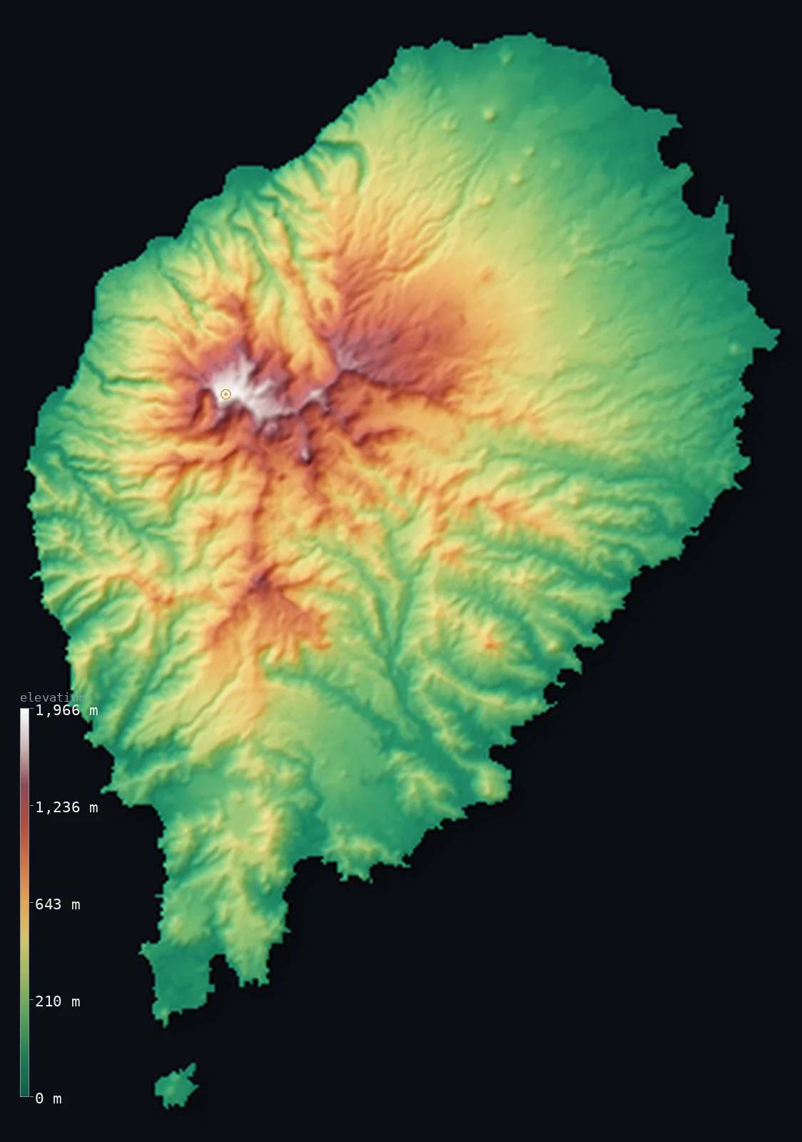
Sao Tome and Principe’s highest point is Pico de Sao Tome at 6,640 ft (2,024 m); its lowest is Atlantic Ocean at 0 ft (0 m); the mean elevation is 1,145 ft (349 m).
São Tomé and Príncipe is a tiny country of two volcanic islands in the Gulf of Guinea, off Gabon — Africa's second-smallest country, after Seychelles. The larger island, São Tomé, is a shield volcano rising from a deep Atlantic floor to its rainforested interior and the highest point, Pico de São Tomé, at 6,640 ft (2,024 m), with the sheer plug of Pico Cão Grande standing as a needle of rock nearby. Both islands belong to the Cameroon Volcanic Line, the chain of volcanoes that runs offshore from Mount Cameroon through Bioko. Half the country lies below about 800 ft, the volcanic interior lifting the mean above. (Príncipe is not shown in this view.)
- Highest point📚
- 6,640 ft2,024 m
- São Tomé and Príncipe's highest point is Pico de São Tomé at 6,640 ft (2,024 m), just west of the centre of São Tomé, the larger island, within the Obo Natural Park. The whole island is a shield volcano rising from an Atlantic floor more than 3,000 m below the sea, part of the Cameroon Volcanic Line — the chain of volcanoes that runs offshore from Mount Cameroon through Bioko to São Tomé and Príncipe. Nearby, the sheer volcanic plug of Pico Cão Grande stands as a needle of rock above the forest.
- Lowest point📚
- 0 ft0 m
- São Tomé and Príncipe's lowest point is the Atlantic Ocean at sea level, in the Gulf of Guinea off the coast of Gabon, just north of the Equator, which passes through the islet of Ilhéu das Rolas off southern São Tomé. From the coasts the land rises steeply through rainforest to the volcanic peaks of the interior.
- Mean elevation⚙
- 1,145 ft349 m
- Computed from the GLO-30 model, São Tomé and Príncipe's mean elevation is 1,145 ft (349 m) — lifted by the volcanic interior, above all Pico de São Tomé, so that half the country lies below about 804 ft (245 m). The low, rainforested coasts are the low majority; the steep volcanic peaks of the interior are the high minority.
- Median elevation⚙
- 804 ft245 m
- Half of São Tomé and Príncipe lies below about 804 ft (245 m) — below the mean, because the country's height is concentrated in the volcanic peaks of the interior, above all Pico de São Tomé, while the coasts and lower forest lie well below. The islands are volcanic and steep, but most of their ground is low, rainforested coast.
- Elevation range📚
- 6,640 ft2,024 m
- From the Atlantic shore to Pico de São Tomé at 2,024 m, the terrain climbs about 6,640 ft — a steep rise for so small a country, from rainforest coast up a shield volcano that stands more than 5,000 m above the deep Atlantic floor from which it grew.
- Above 1,000 m (3,281 ft)⚙
- 6%
- About 6% of São Tomé and Príncipe rises above 1,000 m (3,281 ft) — the volcanic interior of São Tomé island, around Pico de São Tomé. The rainforested coasts and lower slopes lie well below.
- Official area📚
- 372 mi²964 km²
- São Tomé and Príncipe covers about 372 sq mi (964 sq km) — Africa's second-smallest country, after Seychelles: two volcanic islands in the Gulf of Guinea off Gabon, the larger and more mountainous São Tomé (rising to Pico de São Tomé) in the south and the smaller Príncipe about 150 km to the north, both part of the Cameroon Volcanic Line.
- Forest cover📚
- 55.8%
- About 56% of São Tomé and Príncipe is forested — dense equatorial rainforest cloaks the steep volcanic interiors of both islands, much of it protected in the Obo Natural Park, a stronghold of many endemic species on these long-isolated oceanic islands.
Highest and lowest points
The highest point of Sao Tome and Principe at 2,024 m - Pico de Sao Tome, just west of the centre of Sao Tome, the larger island, within the Obo Natural Park. The whole island is a shield volcano rising from the deep Atlantic floor along the Cameroon volcanic line. It is an island interior summit, not on any border. (Coordinate set to the GLO-30 summit grid-max; an earlier point ~7.6 km east read on the flank.)
source ↗São Tomé and Príncipe's lowest point is the Atlantic Ocean at sea level, in the Gulf of Guinea off the coast of Gabon — Africa's second-smallest country, after the Seychelles. It is made of two volcanic islands and their islets. The larger, São Tomé, in the south, is a shield volcano rising from a deep Atlantic floor to its rainforested interior and the high point, Pico de São Tomé, in the Obo Natural Park, with the dramatic sheer-sided plug of Pico Cão Grande rising from the forest nearby. The smaller Príncipe, about 150 km to the north, is lower but still rugged and forested, rising to Pico de Príncipe (948 m). Both islands belong to the Cameroon Volcanic Line — the same chain as Mount Cameroon on the mainland and Bioko in Equatorial Guinea. The Equator passes just south of São Tomé, through the islet of Ilhéu das Rolas. This map renders the larger island of São Tomé; Príncipe, 150 km to the north, is not shown in this view.
source ↗Sao Tome and Principe at a glance
Pico de Sao Tome (2,024 m) is a shield volcano rising from an Atlantic floor more than 3,000 m below sea level.
source ↗The equator passes just south of Sao Tome island, through the small islet of Ilheu das Rolas.
source ↗In southern Sao Tome the Pico Cao Grande rises as a sheer volcanic plug, a needle of rock standing high above the forest.
source ↗Both islands belong to the Cameroon volcanic line, the same chain as Mount Cameroon on the African mainland.
source ↗Sao Tome and Principe is Africa's second-smallest country, after the Seychelles.
source ↗
Elevation profile of Sao Tome and Principe
The largest share of land, 43%, falls in the 0–200 m band, and 75% of the territory lies below 500 m (1,640 ft).
- below 500 m (1,640 ft)75%
- 500–1,000 m19%
- 1,000–2,000 m6%
Highest peaks of Sao Tome and Principe
| Peak | Elevation | Range | Note |
|---|---|---|---|
| Pico de Sao Tome↗ | 6,640 ft2,024 m | Sao Tome Island | Highest point of the country, a shield-volcano summit near the centre of Sao Tome. |
| Pico de Ana Chaves↗ | 5,348 ft1,630 m | Sao Tome Island | The second-highest peak on Sao Tome, a few kilometres southeast of Pico de Sao Tome. |
| Pico de Principe↗ | 3,110 ft948 m | Principe Island | The highest point of Principe, the smaller northern island, in its rainforest interior. |
São Tomé and Príncipe: São Tomé island, Príncipe, and the equatorial islets
São Tomé island
The larger, more mountainous southern island — a shield volcano rising through rainforested hills to Pico de São Tomé (the high point) in the Obo Natural Park, with the dramatic plug of Pico Cão Grande rising from the forest.
Príncipe island
The smaller northern island, about 150 km away — lower but still rugged and forested, rising to Pico de Príncipe (948 m). (Not shown in this view.)
The equatorial islets
The small islands around the two main ones — including Ilhéu das Rolas off southern São Tomé, through which the Equator passes.
How to read this map
Color shows elevation; the raised relief shows real terrain. On this map São Tomé rises as a steep volcanic island — low, rainforested green around its coasts climbing sharply to the high browns of the interior peaks (highest at Pico de São Tomé), a shield volcano built up from the deep Atlantic floor.
The island is steep and volcanic; the 3D exaggeration brings out the interior peaks, and the ×N relief slider controls how much. Tap anywhere to read that point's exact elevation. (The smaller island of Príncipe, 150 km to the north, is not shown in this view.)
City elevations in Sao Tome and Principe
Most of São Tomé and Príncipe's people live on São Tomé, the larger island — São Tomé, the capital, on its northeast coast, with smaller towns like Neves on the northwest coast and Dona Eugénia in the interior, below the rainforested volcanic heights.
| City | Population | Elevation |
|---|---|---|
| São Tomécapitalthe capital, on the northeast coast of São Tomé island ↗ | 53,300 | 23 ft7 m |
| Neveson the northwest coast of São Tomé island ↗ | 8,391 | 36 ft11 m |
| Dona Eugéniain the interior of São Tomé island ↗ | 3,605 | 381 ft116 m |
Elevation sampled at each city centre from the Copernicus GLO-30 model. Cities and population from GeoNames (CC-BY 4.0).
Sao Tome and Principe in comparison
Sao Tome and Principe's terrain rises 6,640 ft (2,024 m) from sea level to Pico de Sao Tome — about 23% of the height of Mount Everest, the world's highest point at 29,032 ft (8,849 m).
- Cabo Verde's mean elevation is 1,060 ft — 85 ft lower; its high point, Pico do Fogo, reaches 9,281 ft (2,829 m), 2,641 ft above. Cabo Verde elevation map →
- Seychelles's mean elevation is 659 ft — 486 ft lower; its high point, Morne Seychellois, reaches 2,969 ft (905 m), 3,671 ft below. Seychelles elevation map →
- Equatorial Guinea's mean elevation is 1,604 ft — 459 ft higher; its high point, Pico Basile, reaches 9,879 ft (3,011 m), 3,238 ft above. Equatorial Guinea elevation map →
Frequently asked questions
What is the highest point in São Tomé and Príncipe?
- Pico de São Tomé, 6,640 ft (2,024 m), a volcanic peak on São Tomé, the larger island, in the Obo Natural Park - part of the Cameroon Volcanic Line.
What is the average elevation of São Tomé and Príncipe?
- No standard source publishes one, so this page reports the mean computed from the Copernicus GLO-30 model, 1,145 ft (349 m) - lifted by the volcanic interior; about half the country lies below about 804 ft (245 m).
What is the lowest point in São Tomé and Príncipe?
- The Atlantic Ocean at sea level, in the Gulf of Guinea off Gabon, near the Equator.
What is the highest point on Príncipe?
- Pico de Príncipe, about 948 m, on the smaller northern island - lower than São Tomé's Pico de São Tomé (2,024 m). Príncipe is not shown on this map, which renders the larger island of São Tomé.
Where is São Tomé and Príncipe?
- In the Gulf of Guinea, off the coast of Gabon, just north of the Equator - two volcanic islands on the Cameroon Volcanic Line, the same chain as Mount Cameroon and Bioko.
Is this a topographic, relief, contour, or elevation map of São Tomé and Príncipe?
- They describe the same thing - terrain height. This page renders São Tomé island's actual elevation surface in interactive 3D and reports the statistics computed from it.
About this map
The terrain is rendered from the Copernicus GLO-30 digital elevation model (ESA), masked to the STP-ADM0 boundary from geoBoundaries (gbOpen). Elevation statistics are computed directly from the model; peak names and researched facts are sourced and cited. See the methodology for the full pipeline.
Our area-weighted mean, computed from the Copernicus GLO-30 model, is 1,145 ft (349 m); no authority publishes a mean elevation (No authoritative published mean elevation). São Tomé and Príncipe is a tiny country of two volcanic islands in the Gulf of Guinea, off Gabon, and its height is gathered in a rainforested volcanic interior. The larger island, São Tomé, is a shield volcano rising from an Atlantic floor more than 3,000 m deep to Pico de São Tomé, the country's highest point, with the sheer plug of Pico Cão Grande standing as a needle of rock nearby; the smaller Príncipe, 150 km to the north, is lower but still rugged. Both belong to the Cameroon Volcanic Line, the chain of volcanoes that runs offshore from Mount Cameroon through Bioko to these islands. Because the steep volcanic peaks tower over low, rainforested coasts, the mean is lifted above the typical point and half the country lies below about 804 ft (245 m). This map renders São Tomé, the larger island; Príncipe, 150 km to the north, is not shown in this view. No standard source publishes a mean elevation for São Tomé and Príncipe; the figure here is computed directly from the GLO-30 surface.
Surveyed national figures: official area · forest cover · high point.
Rendered from Copernicus GLO-30 (ESA, 2021 release), boundaries from geoBoundaries. Generated 2026-06-26.