Cape Verde Elevation Map — Topographic & 3D Terrain
Explore the terrain of Cabo Verde in interactive 3D, built from Copernicus GLO-30 satellite elevation data — a volcanic Atlantic archipelago from flat sandy islands to the active volcano Pico do Fogo. Drag to rotate, scroll to zoom, and tap any point to read its elevation.
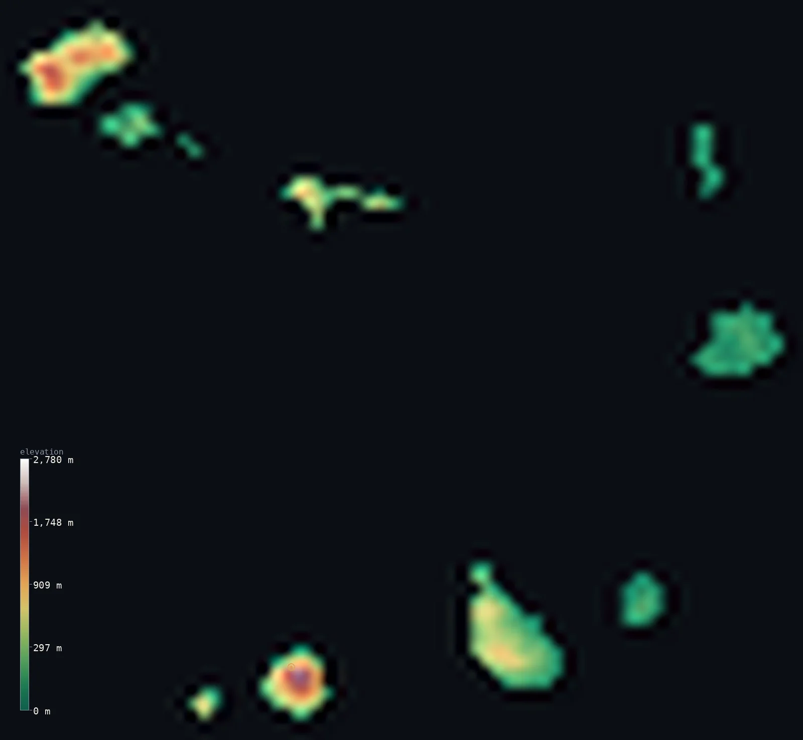
Cabo Verde’s highest point is Pico do Fogo at 9,281 ft (2,829 m); its lowest is Atlantic Ocean at 0 ft (0 m); the mean elevation is 1,060 ft (323 m).
Cabo Verde is a volcanic archipelago of ten islands in the Atlantic, about 600 km off Senegal, and its height is gathered in a few dramatic peaks. The islands are sharply divided: the old eastern ones — Sal, Maio, Boa Vista — are flat, sandy, and beach-fringed, while the younger western islands rise steeply, above all Fogo, essentially a single active volcano whose 'Peak of Fire,' Pico do Fogo, reaches 9,281 ft (2,829 m) — the highest point, and the only active volcano in the archipelago. Because a few volcanic heights tower over much lower ground, half of Cabo Verde lies below about 520 ft, and the mean sits well above.
- Highest point📚
- 9,281 ft2,829 m
- Cabo Verde's highest point is Pico do Fogo at 9,281 ft (2,829 m), an active stratovolcano — the 'Peak of Fire' — on the island of Fogo, and the only active volcano in the archipelago. It rises as a young cone inside an older collapsed caldera, Chã das Caldeiras, where a small community farms grapes for wine on black volcanic soil at about 1,700 m. Fogo last erupted in 2014–15.
- Lowest point📚
- 0 ft0 m
- Cabo Verde's lowest point is the Atlantic Ocean at sea level, around the shores of its ten islands, about 600 km off the coast of Senegal. The islands are sharply divided: the old, low, eastern islands — Sal, Maio, Boa Vista — are flat, sandy, and beach-fringed, while the younger western islands rise steeply to volcanic peaks.
- Mean elevation⚙
- 1,060 ft323 m
- Computed from the GLO-30 model, Cabo Verde's mean elevation is 1,060 ft (323 m) — lifted well above the typical island by the great volcanic cone of Fogo and the steep western islands, for half the archipelago lies below about 522 ft (159 m). The flat, sandy eastern islands and the low coasts are the low majority; the volcanic heights are a dramatic minority.
- Median elevation⚙
- 522 ft159 m
- Half of Cabo Verde lies below about 522 ft (159 m) — far below the mean, because the archipelago's height is concentrated in a few volcanic peaks, above all Pico do Fogo, while much of the land — the flat eastern islands of Sal, Maio, and Boa Vista and the low coasts everywhere — lies low. The islands are volcanic, but most of their ground is not high.
- Elevation range📚
- 9,281 ft2,829 m
- From the Atlantic shore to Pico do Fogo at 2,829 m, Cabo Verde's terrain climbs about 9,281 ft — a great range for so small an archipelago, from flat, sandy, beach-fringed islands up an active volcano, all built by a hotspot on the Cape Verde Ridge in the mid-Atlantic.
- Above 1,000 m (3,281 ft)⚙
- 7%
- About 7% of Cabo Verde rises above 1,000 m (3,281 ft) — the volcanic heights of the younger western islands, above all Fogo (with Pico do Fogo) and Santo Antão. The flat eastern islands and the low coasts lie well below.
- Official area📚
- 1,557 mi²4,033 km²
- Cabo Verde covers about 1,557 sq mi (4,033 sq km) — a volcanic archipelago of ten islands in the Atlantic about 600 km off Senegal, split by the trade winds into the windward Barlavento group (Santo Antão, São Vicente, Sal, Boa Vista and others) and the leeward Sotavento (Santiago, the largest, with the capital Praia; Fogo, with the active volcano; Maio and Brava).
- Forest cover📚
- 11%
- About 11% of Cabo Verde is forested — a dry, largely treeless archipelago of the Sahelian Atlantic, with woodland and terraced farmland on the wetter, higher slopes of the western islands and little vegetation on the arid eastern ones.
Highest and lowest points
An active stratovolcano on the island of Fogo — the highest point of Cabo Verde at 2,829 m, and the only active volcano in the archipelago. Its name means 'Peak of Fire'. It rises as a young cone inside an older collapsed caldera (Chã das Caldeiras), whose 1,000 m crater wall is called the Bordeira; it last erupted in 2014–15.
source ↗Cabo Verde's lowest point is the Atlantic Ocean at sea level, around the shores of its ten islands, about 600 km west of Senegal. The trade winds split the archipelago into two groups: the windward Barlavento to the north (Santo Antão, São Vicente, Sal, Boa Vista and others) and the leeward Sotavento to the south (Santiago, the largest and most populous, with the capital Praia; Fogo, Maio, and Brava). The islands differ sharply in age and shape: the old eastern islands — Sal, Maio, Boa Vista — are flat, sandy, and low, ringed by beaches, while the younger western islands rise steeply to volcanic peaks. Highest of all is Fogo, essentially one great active volcano: its Pico do Fogo, the 'Peak of Fire,' rises inside a collapsed caldera whose sheer wall, the Bordeira, stands up to 1,000 m high, and where a community farms vines on the black soil. The whole archipelago is volcanic, raised by a hotspot on the Cape Verde Ridge in the mid-Atlantic.
source ↗Cabo Verde at a glance
Cabo Verde's highest point, Pico do Fogo (2,829 m), is the archipelago's only active volcano — it last erupted in 2014–15, burying villages in the caldera where people had returned to live.
source ↗A community lives and farms grapes for wine inside the volcano's caldera, Chã das Caldeiras, on black volcanic soil at about 1,700 m — the only place in Cabo Verde where wine is grown.
source ↗Fogo is essentially a single volcano about 25 km across; its caldera wall, the Bordeira, is a near-vertical cliff up to 1,000 m high.
source ↗About 73,000 years ago the eastern flank of Fogo collapsed into the sea, generating a tsunami around 170 m high that struck the neighbouring island of Santiago.
source ↗The ten islands are split by the trade winds into two groups — the windward Barlavento to the north and the leeward Sotavento to the south.
source ↗The islands are sharply divided in character: the old eastern islands (Sal, Maio, Boa Vista) are flat, sandy and beach-fringed, while the younger western ones are steep, rugged and mountainous.
source ↗The whole archipelago is volcanic, built up by a hotspot under the African Plate from the Cape Verde Ridge — a vast rise on the Atlantic seabed.
source ↗
Elevation profile of Cabo Verde
The largest share of land, 55%, falls in the 0–200 m band, and 78% of the territory lies below 500 m (1,640 ft).
- below 500 m (1,640 ft)78%
- 500–1,000 m14%
- 1,000–2,000 m7%
- above 2,000 m (6,562 ft)<1%
Highest peaks of Cabo Verde
| Peak | Elevation | Range | Note |
|---|---|---|---|
| Pico do Fogo↗ | 9,281 ft2,829 m | Fogo (Sotavento) | Highest point of Cabo Verde and its only active volcano, a young cone inside the Chã das Caldeiras caldera. |
| Topo de Coroa↗ | 6,493 ft1,979 m | Santo Antão (Barlavento) | The highest point of Santo Antão, the rugged northwestern island, and the second-highest in Cabo Verde. |
| Pico d'Antónia↗ | 4,573 ft1,394 m | Santiago (Sotavento) | The highest peak of Santiago, the largest island, overlooking green interior valleys and the capital Praia. |
| Monte Gordo↗ | 4,304 ft1,312 m | São Nicolau (Barlavento) | The highest point of São Nicolau, within a protected nature reserve of native plants and animals. |
| Monte Fontainhas↗ | 3,202 ft976 m | Brava (Sotavento) | The highest point of Brava, the smallest inhabited island, known as the 'Island of Flowers'. |
Cabo Verde: the windward and leeward islands, and fire beside sand
The windward islands (Barlavento)
The northern group facing the trade winds — Santo Antão (rising near 2,000 m), São Vicente, São Nicolau, and the flat, sandy eastern islands of Sal and Boa Vista.
The leeward islands (Sotavento)
The southern group — Santiago, the largest, holding the capital Praia; Fogo, a single great active volcano crowned by Pico do Fogo; and Maio and Brava.
Fire beside sand
The archipelago is split in character: the old eastern islands are low, flat, and sandy, while the young western ones rise to volcanic peaks — highest of all Fogo, where a community farms vines inside the caldera of the active volcano.
How to read this map
Color shows elevation; the raised relief shows real terrain. On this map Cabo Verde reads as scattered islands of sharply different height — the flat, low tones of the sandy eastern islands (Sal, Maio, Boa Vista) beside the steep browns of the volcanic western ones, rising highest to the great cone of Fogo (with Pico do Fogo).
The islands sit far apart across the sea, so the map spans open ocean between them; the 3D exaggeration brings out the volcanic relief, and the ×N relief slider controls how much. Tap anywhere to read that point's exact elevation.
City elevations in Cabo Verde
Cabo Verde's cities are scattered across its islands — Praia, the capital, on Santiago, the largest island, with Mindelo on São Vicente in the north, São Filipe below the volcano on Fogo, and towns like Espargos (Sal) and Sal Rei (Boa Vista) on the flat eastern islands.
| City | Population | Elevation |
|---|---|---|
| Praiacapitalthe capital, on Santiago, the largest island ↗ | 137,868 | 75 ft23 m |
| Mindeloon São Vicente, in the northern Barlavento group ↗ | 69,013 | 154 ft47 m |
| Espargoson the flat eastern island of Sal ↗ | 24,500 | 171 ft52 m |
| Assomadain the interior of Santiago ↗ | 21,297 | 1,322 ft403 m |
| Sal Reion the flat eastern island of Boa Vista ↗ | 10,936 | 16 ft5 m |
| São Filipeon Fogo, below the volcano Pico do Fogo ↗ | 10,097 | 341 ft104 m |
| Vila do Maio | 4,472 | 62 ft19 m |
| Tarrafal de São Nicolau | 4,371 | 33 ft10 m |
| Ponta do Solon the mountainous western island of Santo Antão ↗ | 3,300 | 62 ft19 m |
Elevation sampled at each city centre from the Copernicus GLO-30 model. Cities and population from GeoNames (CC-BY 4.0).
Cabo Verde in comparison
Cabo Verde's terrain rises 9,281 ft (2,829 m) from sea level to Pico do Fogo — about 32% of the height of Mount Everest, the world's highest point at 29,032 ft (8,849 m).
- Sao Tome and Principe's mean elevation is 1,145 ft — 85 ft higher; its high point, Pico de Sao Tome, reaches 6,640 ft (2,024 m), 2,641 ft below. Sao Tome and Principe elevation map →
- Comoros's mean elevation is 1,617 ft — 558 ft higher; its high point, Mount Karthala, reaches 7,746 ft (2,361 m), 1,535 ft below. Comoros elevation map →
- Mauritius's mean elevation is 709 ft — 351 ft lower; its high point, Piton de la Petite Riviere Noire, reaches 2,717 ft (828 m), 6,565 ft below. Mauritius elevation map →
Frequently asked questions
What is the highest point in Cabo Verde?
- Pico do Fogo, 9,281 ft (2,829 m), an active volcano on the island of Fogo - the 'Peak of Fire,' the only active volcano in the archipelago.
Is Pico do Fogo an active volcano?
- Yes - it is the only active volcano in Cabo Verde, and last erupted in 2014-15, burying villages in its caldera, Chã das Caldeiras.
What is the average elevation of Cabo Verde?
- No standard source publishes one, so this page reports the mean computed from the Copernicus GLO-30 model, 1,060 ft (323 m) - lifted by the volcanic peaks; about half the archipelago lies below about 522 ft (159 m).
How many islands does Cabo Verde have?
- Ten main islands, split by the trade winds into the windward Barlavento group to the north and the leeward Sotavento to the south - the largest is Santiago, with the capital Praia.
What is Chã das Caldeiras?
- The community living inside Pico do Fogo's collapsed caldera, at about 1,700 m - the only place in Cabo Verde inside an active volcano, where people farm grapes for wine on black volcanic soil.
Is this a topographic, relief, contour, or elevation map of Cabo Verde?
- They describe the same thing - terrain height. This page renders the archipelago's actual elevation surface in interactive 3D and reports the statistics computed from it.
About this map
The terrain is rendered from the Copernicus GLO-30 digital elevation model (ESA), masked to the CPV-ADM0 boundary from geoBoundaries (gbOpen). Elevation statistics are computed directly from the model; peak names and researched facts are sourced and cited. See the methodology for the full pipeline.
Our area-weighted mean, computed from the Copernicus GLO-30 model, is 1,060 ft (323 m); no authority publishes a mean elevation (No authoritative published mean elevation). Cabo Verde is a volcanic archipelago of ten islands in the Atlantic, and its height is gathered in a few dramatic peaks. The islands are sharply divided: the old eastern ones — Sal, Maio, Boa Vista — are flat, sandy, and beach-fringed, while the younger western islands rise steeply, above all Fogo, essentially a single active volcano 25 km across whose 'Peak of Fire,' Pico do Fogo, is the country's highest point. Because a few volcanic heights tower over much lower ground, the mean is lifted well above the typical island and half of Cabo Verde lies below about 522 ft (159 m). It is a young, restless land — Fogo last erupted in 2014–15 — built up over a volcanic hotspot on the Cape Verde Ridge. No standard source publishes a mean elevation for Cabo Verde; the figure here is computed directly from the GLO-30 surface.
Surveyed national figures: official area · forest cover · high point.
Rendered from Copernicus GLO-30 (ESA, 2021 release), boundaries from geoBoundaries. Generated 2026-07-25.