Comoros Elevation Map — Topographic & 3D Terrain
Explore the terrain of the Comoros in interactive 3D, built from Copernicus GLO-30 satellite elevation data — a volcanic archipelago in the Mozambique Channel, dominated by the active Mount Karthala. Drag to rotate, scroll to zoom, and tap any point to read its elevation.
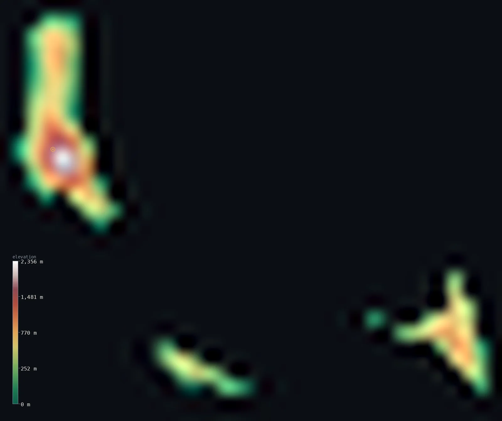
Comoros’s highest point is Mount Karthala at 7,746 ft (2,361 m); its lowest is Indian Ocean at 0 ft (0 m); the mean elevation is 1,617 ft (493 m).
The Comoros is a small volcanic archipelago in the Mozambique Channel, between Madagascar and the African mainland, and a single great volcano dominates its height. Grande Comore, the largest and youngest island, is topped by Mount Karthala — an active shield volcano, one of the world's most frequently erupting, reaching 7,746 ft (2,361 m), the country's highest point. The older islands, Anjouan and Mohéli, are more worn. Because Karthala towers over lower, worn islands and coasts, half of the Comoros lies below about 1,270 ft, while Karthala's volcanic mass lifts the mean far higher. (A fourth island, Mayotte, is administered by France though claimed by the Comoros.)
- Highest point📚
- 7,746 ft2,361 m
- The Comoros' highest point is Mount Karthala at 7,746 ft (2,361 m), an active basaltic shield volcano at the southern end of Grande Comore (Ngazidja), the largest and youngest island. One of the world's most active volcanoes, it has erupted more than twenty times since the 19th century, and has a 3-by-4 km summit caldera. Four bird species live nowhere on Earth but its slopes.
- Lowest point📚
- 0 ft0 m
- The Comoros' lowest point is the Indian Ocean at sea level, around the shores of its three islands in the Mozambique Channel, between Madagascar and the African mainland. From the coasts the land rises steeply — most dramatically on Grande Comore, straight up the flanks of Karthala.
- Mean elevation⚙
- 1,617 ft493 m
- Computed from the GLO-30 model, the Comoros' mean elevation is 1,617 ft (493 m) — lifted by the volcanoes, above all the great mass of Karthala, so that half the country lies below about 1,270 ft (387 m). The lower coasts and the older, more worn islands are the low majority; Karthala's young volcanic bulk is the high minority.
- Median elevation⚙
- 1,270 ft387 m
- Half of the Comoros lies below about 1,270 ft (387 m) — below the mean, because the country's height is concentrated in the volcanoes, chiefly the young active mass of Karthala on Grande Comore, while the older islands of Anjouan and Mohéli and the coasts everywhere lie lower. The islands are volcanic, but Karthala towers over the rest.
- Elevation range📚
- 7,746 ft2,361 m
- From the Indian Ocean shore to Mount Karthala at 2,361 m, the Comoros' terrain climbs about 7,746 ft — a wide range for a small country, from coral coast straight up an active shield volcano, the youngest and highest feature of an archipelago that grows younger toward the northwest.
- Above 1,000 m (3,281 ft)⚙
- 12%
- About 12% of the Comoros rises above 1,000 m (3,281 ft) — chiefly the volcanic highlands of Grande Comore (Karthala and the extinct La Grille) and the central peak of Anjouan (Mtingui). The lower coasts and Mohéli lie below.
- Official area📚
- 719 mi²1,861 km²
- The Comoros covers about 719 sq mi (1,861 sq km) — a small volcanic archipelago in the Mozambique Channel: Grande Comore (Ngazidja), the largest and youngest, dominated by the active Karthala; the older, triangular Anjouan (Ndzuani), radiating from Mtingui; and the small Mohéli (Mwali). (A fourth island, Mayotte, is administered by France though claimed by the Comoros.)
- Forest cover📚
- 19.6%
- About 20% of the Comoros is forested — remnants of tropical rain forest on the wet volcanic slopes, above all on Karthala and in the surviving stands of Mohéli, with much of the lower land cleared for farming.
Highest and lowest points
An active basaltic shield volcano at the southern end of Grande Comore (Ngazidja), the largest island — the highest point of the Comoros at 2,361 m. It has a 3 × 4 km summit caldera and has erupted more than twenty times since the 19th century, most recently in the 2000s; an 1860 lava flow reached the coast near the capital, Moroni.
source ↗The Comoros' lowest point is the Indian Ocean at sea level, around the shores of its three islands in the Mozambique Channel. The Union of the Comoros comprises Grande Comore (Ngazidja), Anjouan (Ndzuani), and Mohéli (Mwali); a fourth island of the archipelago, Mayotte, is administered by France though claimed by the Comoros. Grande Comore, the largest and youngest, is dominated by two volcanoes — the active Karthala, the country's highest point, so young and porous that the island holds no surface water and islanders store rainfall in tanks, and the extinct La Grille to the north. Anjouan is an older, triangular island where three mountain chains radiate from the central peak Mtingui (1,575 m); Mohéli, the smallest, has a central chain reaching about 860 m and surviving rain forest. From coral coasts the land rises steeply to these volcanic heights — the islands growing younger toward the northwest, over a volcanic hotspot.
source ↗Comoros at a glance
The Comoros' highest point, Mount Karthala (2,361 m), is one of the world's most active volcanoes — it has erupted more than twenty times since the 19th century.
source ↗Grande Comore is so young geologically that its porous volcanic rock holds no surface water — islanders must store rainfall in catchment tanks.
source ↗An 1860 lava flow from Karthala's caldera travelled about 13 km to reach the west coast just north of the capital, Moroni.
source ↗Four bird species live nowhere on Earth but the slopes of Mount Karthala — the Karthala scops owl, Karthala white-eye, Comoro drongo and Humblot's flycatcher.
source ↗The islands get younger toward the northwest — Mayotte is the oldest, Grande Comore the youngest — consistent with formation over a volcanic hotspot.
source ↗The Union of the Comoros comprises three islands; the fourth island of the archipelago, Mayotte, is administered by France though claimed by the Comoros.
source ↗
Elevation profile of Comoros
The largest share of land, 29%, falls in the 0–200 m band, and 63% of the territory lies below 500 m (1,640 ft).
- below 500 m (1,640 ft)63%
- 500–1,000 m25%
- 1,000–2,000 m11%
- above 2,000 m (6,562 ft)1%
Highest peaks of Comoros
| Peak | Elevation | Range | Note |
|---|---|---|---|
| Mount Karthala↗ | 7,746 ft2,361 m | Grande Comore (Ngazidja) | Highest point of the Comoros, an active shield volcano with a large summit caldera. |
| Mtingui↗ | 5,167 ft1,575 m | Anjouan (Ndzuani) | The central peak of Anjouan, from which three mountain chains radiate, giving the island its distinctive shape. |
| La Grille↗ | 3,281 ft1,000 m | Grande Comore (Ngazidja) | An extinct, largely eroded volcano forming the northern end of Grande Comore, linked to Karthala by a 600–700 m plateau. |
| Mohéli central chain↗ | 2,822 ft860 m | Mohéli (Mwali) | The high point of the central mountain chain of Mohéli, the smallest of the Union's three islands. |
The Comoros: Grande Comore, Anjouan, and Mohéli
Grande Comore (Ngazidja)
The largest and youngest island, dominated by two volcanoes — the active Karthala (the high point) in the south and the extinct La Grille to the north. So young and porous it holds no surface water.
Anjouan (Ndzuani)
An older, triangular island where three mountain chains radiate from the central peak Mtingui (1,575 m), with deeper soils on its worn volcanic slopes.
Mohéli (Mwali)
The smallest island, with a central mountain chain reaching about 860 m and surviving stands of rain forest.
How to read this map
Color shows elevation; the raised relief shows real terrain. On this map the Comoros shows its three islands, each rising from the sea — most dramatically Grande Comore in the northwest, a broad shield climbing to the high browns of the active Karthala, with the older, more worn Anjouan and Mohéli to the southeast.
The islands sit apart across the channel; the 3D exaggeration brings out the volcanic relief, and the ×N relief slider controls how much. Tap anywhere to read that point's exact elevation.
City elevations in Comoros
The Comoros' towns lie on the coasts of its three islands — Moroni, the capital, on Grande Comore beneath Karthala, with Moutsamoudou and Domoni on Anjouan and Fomboni on Mohéli.
| City | Population | Elevation |
|---|---|---|
| Moronicapitalthe capital, on Grande Comore beneath Karthala ↗ | 74,749 | 75 ft23 m |
| Moutsamoudouthe main town of Anjouan ↗ | 26,313 | 194 ft59 m |
| Fombonithe main town of Mohéli ↗ | 17,291 | 46 ft14 m |
| Domonion the east coast of Anjouan ↗ | 12,262 | 135 ft41 m |
| Nkourani | 10,000 | 13 ft4 m |
| Mbéni | 5,128 | 1,562 ft476 m |
| Foumbounion the south coast of Grande Comore ↗ | 3,386 | 36 ft11 m |
| Singani | 2,309 | 390 ft119 m |
| Bimbini | 2,052 | 476 ft145 m |
Elevation sampled at each city centre from the Copernicus GLO-30 model. Cities and population from GeoNames (CC-BY 4.0).
Comoros in comparison
Comoros's terrain rises 7,746 ft (2,361 m) from sea level to Mount Karthala — about 27% of the height of Mount Everest, the world's highest point at 29,032 ft (8,849 m).
- Cabo Verde's mean elevation is 1,060 ft — 558 ft lower; its high point, Pico do Fogo, reaches 9,281 ft (2,829 m), 1,535 ft above. Cabo Verde elevation map →
- Mauritius's mean elevation is 709 ft — 909 ft lower; its high point, Piton de la Petite Riviere Noire, reaches 2,717 ft (828 m), 5,030 ft below. Mauritius elevation map →
- Seychelles's mean elevation is 659 ft — 958 ft lower; its high point, Morne Seychellois, reaches 2,969 ft (905 m), 4,777 ft below. Seychelles elevation map →
Frequently asked questions
What is the highest point in the Comoros?
- Mount Karthala, 7,746 ft (2,361 m), an active shield volcano on Grande Comore - one of the world's most active volcanoes, with a large summit caldera.
Is Mount Karthala an active volcano?
- Yes - it is one of the world's most active, having erupted more than twenty times since the 19th century; an 1860 lava flow reached the west coast near the capital, Moroni.
What is the average elevation of the Comoros?
- No standard source publishes one, so this page reports the mean computed from the Copernicus GLO-30 model, 1,617 ft (493 m) - lifted by the volcanoes; about half the country lies below about 1,270 ft (387 m).
How many islands make up the Comoros?
- The Union of the Comoros has three islands - Grande Comore, Anjouan, and Mohéli. A fourth, Mayotte, is administered by France though claimed by the Comoros.
Why does Grande Comore have no rivers?
- It is so young geologically that its porous volcanic rock holds no surface water - islanders must store rainfall in catchment tanks.
Is this a topographic, relief, contour, or elevation map of the Comoros?
- They describe the same thing - terrain height. This page renders the archipelago's actual elevation surface in interactive 3D and reports the statistics computed from it.
About this map
The terrain is rendered from the Copernicus GLO-30 digital elevation model (ESA), masked to the COM-ADM0 boundary from geoBoundaries (gbOpen). Elevation statistics are computed directly from the model; peak names and researched facts are sourced and cited. See the methodology for the full pipeline.
Our area-weighted mean, computed from the Copernicus GLO-30 model, is 1,617 ft (493 m); no authority publishes a mean elevation (No authoritative published mean elevation). The Comoros is a small volcanic archipelago in the Mozambique Channel, between Madagascar and the African mainland, and its height is dominated by a single great volcano. Grande Comore, the largest and youngest island, is topped by Karthala — an active basaltic shield, one of the world's most frequently erupting volcanoes, whose broad mass makes up most of the country's high ground. The older islands, Anjouan and Mohéli, are more worn, radiating from central peaks. Because Karthala and the volcanic highlands tower over lower, worn islands and coasts, the mean is lifted above the typical point and half of the Comoros lies below about 1,270 ft (387 m). The islands grow younger toward the northwest, a signature of their formation over a volcanic hotspot. No standard source publishes a mean elevation for the Comoros; the figure here is computed directly from the GLO-30 surface.
Surveyed national figures: official area · forest cover · high point.
Rendered from Copernicus GLO-30 (ESA, 2021 release), boundaries from geoBoundaries. Generated 2026-07-25.