Seychelles Elevation Map — Topographic & 3D Terrain
Explore the terrain of Seychelles in interactive 3D, built from Copernicus GLO-30 satellite elevation data — the world's only granite oceanic islands, steep and forested, rising to Morne Seychellois on Mahé. Drag to rotate, scroll to zoom, and tap any point to read its elevation.
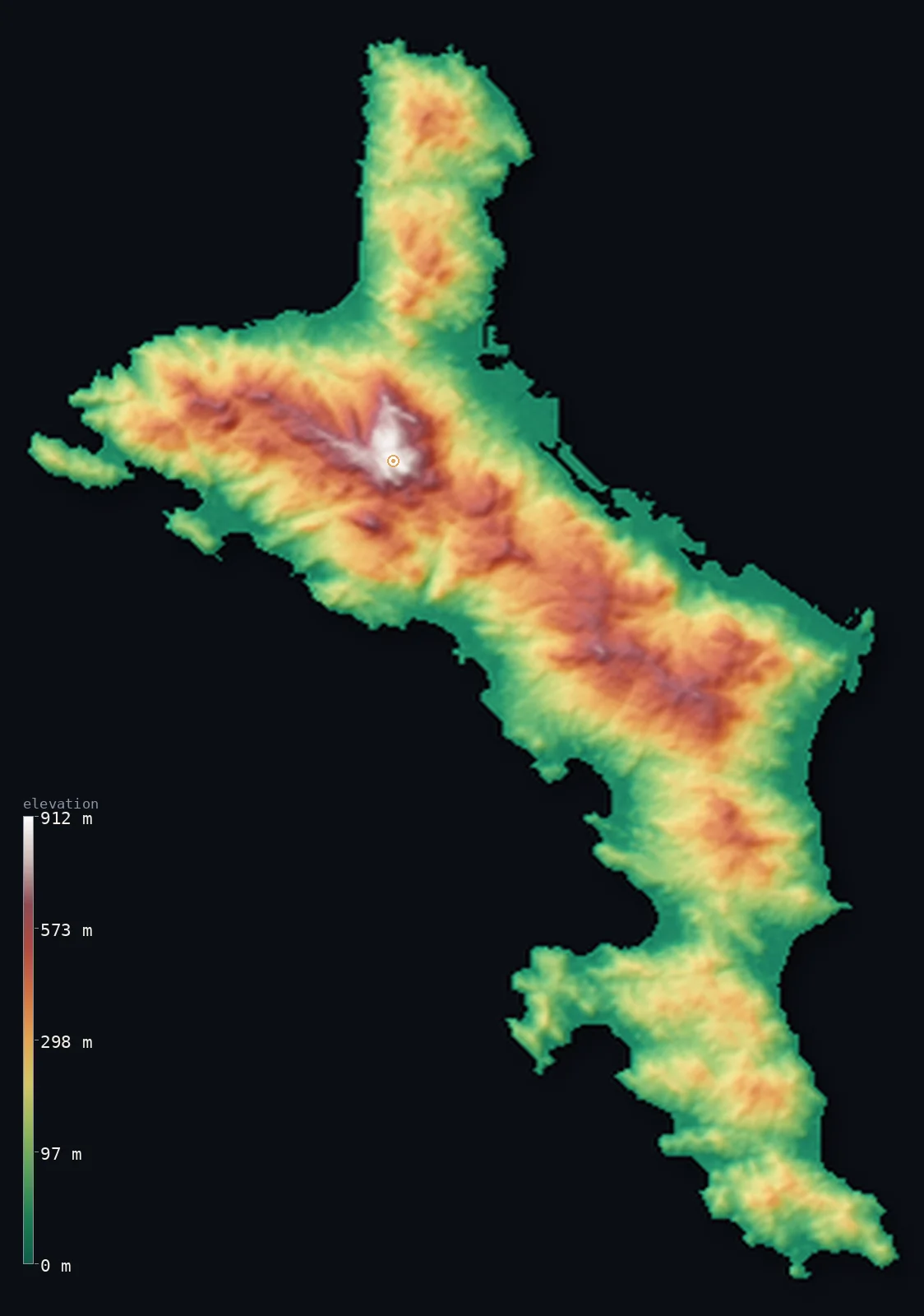
Seychelles’s highest point is Morne Seychellois at 2,969 ft (905 m); its lowest is Indian Ocean at 0 ft (0 m); the mean elevation is 659 ft (201 m).
Seychelles is the odd one out among the African islands: it is not volcanic. Its inner islands are the world's only oceanic islands made of granite — ancient fragments of continental crust left in the Indian Ocean when the continents broke apart, among the oldest oceanic islands on Earth. Their steep, forested hills rise straight from narrow coasts, highest at Morne Seychellois on Mahé, reaching 2,969 ft (905 m), where almost the whole population lives. Scattered far to the southwest are low coral atolls, including Aldabra, the world's largest raised coral atoll. Half of Seychelles lies below about 500 ft, the steep inner-island hills lifting the mean above. (This map renders Mahé; the other islands are not shown in this view.)
- Highest point📚
- 2,969 ft905 m
- Seychelles's highest point is Morne Seychellois at 2,969 ft (905 m), in the rugged granite interior of Mahé, the largest island, within Morne Seychellois National Park above the capital, Victoria. Unlike every other African island, Seychelles is not volcanic: its inner islands are the world's only oceanic islands made of granite — ancient fragments of continental rock left behind when the continents broke apart, among the oldest oceanic islands on Earth.
- Lowest point📚
- 0 ft0 m
- Seychelles's lowest point is the Indian Ocean at sea level. The country's inner islands are granite, with steep forested hills rising straight from narrow coasts, while its outer islands are low coral atolls and sand cays — some barely a metre above the sea, with no fresh water and no permanent residents.
- Mean elevation⚙
- 659 ft201 m
- Computed from the GLO-30 model, Seychelles's mean elevation is 659 ft (201 m) — lifted by the steep hills of the inner islands, so that half the country lies below about 505 ft (154 m). The narrow coasts of the granite islands and the flat coral outer islands are the low majority; the rugged granite interior of Mahé is the high minority.
- Median elevation⚙
- 505 ft154 m
- Half of Seychelles lies below about 505 ft (154 m) — below the mean, because the country's height is confined to the steep hills of the inner islands, above all Mahé, while the coasts are narrow and low and the outer islands are flat coral. Seychelles is a country of granite peaks and coral flats, with little middle ground.
- Elevation range📚
- 2,969 ft905 m
- From the Indian Ocean shore to Morne Seychellois at 905 m, Seychelles's terrain climbs about 2,969 ft — a steep rise for so small a country, straight up the granite interior of Mahé; the outer coral islands, by contrast, barely rise above the sea.
- Official area📚
- 176 mi²455 km²
- Seychelles covers about 176 sq mi (455 sq km) — a small country spread over more than 1.3 million sq km of the Indian Ocean, in two kinds of island: the mountainous granite inner islands (Mahé, holding Morne Seychellois and the capital Victoria; Praslin; La Digue), where almost everyone lives, and the low coral outer islands scattered far to the southwest, including Aldabra, the world's largest raised coral atoll.
- Forest cover📚
- 73.3%
- About 73% of Seychelles is forested — steep, densely wooded granite hills on the inner islands, much of it protected (Morne Seychellois National Park covers a fifth of Mahé), with palm forest on Praslin and mangroves and coral scrub on the low outer islands.
Highest and lowest points
The highest point of Seychelles at 905 m - Morne Seychellois, in the rugged granite interior of Mahe, the largest island, within the Morne Seychellois National Park above the capital, Victoria. It is an island interior summit, not on any border.
source ↗Seychelles's lowest point is the Indian Ocean at sea level. The country is spread over more than 1.3 million sq km of ocean, though its land adds up to only about 455 sq km, and it comes in two utterly different kinds. The inner islands — Mahé, Praslin, La Digue — are granite — built not of volcanic rock but of ancient continental crust, fragments of the old supercontinent left behind when Africa and India drifted apart, and among the oldest oceanic islands on Earth. Their steep, forested hills rise straight from narrow coasts, highest at Morne Seychellois on Mahé, in a national park above the capital, Victoria, where the great majority of Seychellois live. Far to the southwest lie the outer islands — low coral atolls and sand cays, including Aldabra, the world's largest raised coral atoll and about a third of the country's land, so low that most have no fresh water and no permanent residents. This map renders Mahé, the main island; the other inner granite islands and the distant coral islands are not shown in this view.
source ↗Seychelles at a glance
The inner islands of Seychelles are the world's only oceanic islands made of granite - ancient fragments of continental rock, not volcanoes.
source ↗About a third of the country's land is a single feature - Aldabra, the world's largest raised coral atoll.
source ↗The islands are spread over an ocean area of more than 1.3 million km2, but the land adds up to only about 455 km2.
source ↗Almost the whole population lives on the granite islands, the great majority on Mahe alone.
source ↗The coral outer islands are so low - often barely a metre above the sea - that most have no fresh water and no permanent residents.
source ↗
Elevation profile of Seychelles
The largest share of land, 37%, falls in the 0–100 m band, and 93% of the territory lies below 500 m (1,640 ft).
- below 500 m (1,640 ft)93%
- 500–1,000 m7%
Highest peaks of Seychelles
| Peak | Elevation | Range | Note |
|---|---|---|---|
| Morne Seychellois↗ | 2,969 ft905 m | Mahe (granitic inner islands) | Highest point of Seychelles, in the granite interior of Mahe above Victoria. |
| Mont Dauban↗ | 2,428 ft740 m | Silhouette Island (granitic inner islands) | The high point of Silhouette, the second-highest of the granite islands, northwest of Mahe. |
Seychelles: the granite inner islands and the coral outer islands
The granite inner islands
The mountainous core — granite islands with steep, forested hills and narrow coasts, including Mahé (the largest, holding Morne Seychellois and the capital, Victoria), Praslin, and La Digue, where almost everyone lives — ancient continental fragments, not volcanoes.
The coral outer islands
Low, flat coral atolls and sand cays scattered far to the southwest — including Aldabra, the world's largest raised coral atoll — often barely a metre above the sea, most with no fresh water and no permanent residents.
How to read this map
Color shows elevation; the raised relief shows real terrain. On this map Seychelles shows Mahé, the main granite island — a small island rising steeply in the browns of its rugged granite interior (highest at Morne Seychellois) straight from narrow low-green coasts, quite unlike a volcano's smooth cone.
The granite hills are steep and old; the 3D exaggeration brings out their relief, and the ×N relief slider controls how much. Tap anywhere to read that point's exact elevation. (The other inner islands and the distant low coral islands are not shown in this view.)
City elevations in Seychelles
Almost all of Seychelles lives on the granite inner islands — Victoria, the capital, on the northeast coast of Mahé, the largest island, with smaller settlements like Takamaka around Mahé's mountainous, forested interior.
| City | Population | Elevation |
|---|---|---|
| Victoriacapitalthe capital, on the northeast coast of Mahé ↗ | 22,881 | 20 ft6 m |
| Takamakain the south of Mahé, below the granite hills ↗ | 2,580 | 807 ft246 m |
Elevation sampled at each city centre from the Copernicus GLO-30 model. Cities and population from GeoNames (CC-BY 4.0).
Seychelles in comparison
Seychelles's terrain rises 2,969 ft (905 m) from sea level to Morne Seychellois — about 10% of the height of Mount Everest, the world's highest point at 29,032 ft (8,849 m).
- Mauritius's mean elevation is 709 ft — 49 ft higher; its high point, Piton de la Petite Riviere Noire, reaches 2,717 ft (828 m), 253 ft below. Mauritius elevation map →
- Comoros's mean elevation is 1,617 ft — 958 ft higher; its high point, Mount Karthala, reaches 7,746 ft (2,361 m), 4,777 ft above. Comoros elevation map →
- Maldives's mean elevation is 2 ft — 658 ft lower; its high point, Mount Villingili (Villingili Island), reaches 7 ft (2 m), 2,963 ft below. Maldives elevation map →
Frequently asked questions
What is the highest point in Seychelles?
- Morne Seychellois, 2,969 ft (905 m), in the granite interior of Mahé - the country is not volcanic but granite, so its high point is a granite peak, not a volcano.
What is the average elevation of Seychelles?
- No standard source publishes one, so this page reports the mean computed from the Copernicus GLO-30 model, 659 ft (201 m) - lifted by the granite hills of the inner islands; about half the country lies below about 505 ft (154 m).
What is the lowest point in Seychelles?
- The Indian Ocean at sea level - and the outer coral islands are barely a metre above it.
Why are the Seychelles islands made of granite?
- The inner islands are fragments of ancient continental crust, left in the Indian Ocean when the continents broke apart - the world's only oceanic islands made of granite rather than volcanic rock, among the oldest oceanic islands on Earth.
What is Aldabra?
- The world's largest raised coral atoll, in the low outer islands of Seychelles far to the southwest - about a third of the country's land.
Is this a topographic, relief, contour, or elevation map of Seychelles?
- They describe the same thing - terrain height. This page renders the main island of Mahé's actual elevation surface in interactive 3D and reports the statistics computed from it.
About this map
The terrain is rendered from the Copernicus GLO-30 digital elevation model (ESA), masked to the SYC-ADM0 boundary from geoBoundaries (gbOpen). Elevation statistics are computed directly from the model; peak names and researched facts are sourced and cited. See the methodology for the full pipeline.
Our area-weighted mean, computed from the Copernicus GLO-30 model, is 659 ft (201 m); no authority publishes a mean elevation (No authoritative published mean elevation). Seychelles is the odd one out among the African islands: it is not volcanic. Its inner islands are made of granite — ancient fragments of continental crust left stranded in the Indian Ocean when the continents broke apart, among the oldest oceanic islands on Earth. Their steep, forested hills rise straight from narrow coasts, highest at Morne Seychellois on Mahé, where almost the whole population lives. Scattered far to the southwest are the country's other islands — low coral atolls and cays, including Aldabra, the world's largest raised coral atoll, some barely a metre above the sea. Because the height is confined to the granite hills while the coasts and coral flats are low, the mean is lifted above the typical point and half of Seychelles lies below about 505 ft (154 m). This map renders Mahé, the main granite island; the other inner islands (Praslin, La Digue) and the distant coral islands are not shown in this view. No standard source publishes a mean elevation for Seychelles; the figure here is computed directly from the GLO-30 surface.
Surveyed national figures: official area · forest cover · high point.
Rendered from Copernicus GLO-30 (ESA, 2021 release), boundaries from geoBoundaries. Generated 2026-06-26.