Mauritius Elevation Map — Topographic & 3D Terrain
Explore the terrain of Mauritius in interactive 3D, built from Copernicus GLO-30 satellite elevation data — an eroded volcanic island of central plateau, broken mountain rings, and coral reef. Drag to rotate, scroll to zoom, and tap any point to read its elevation.
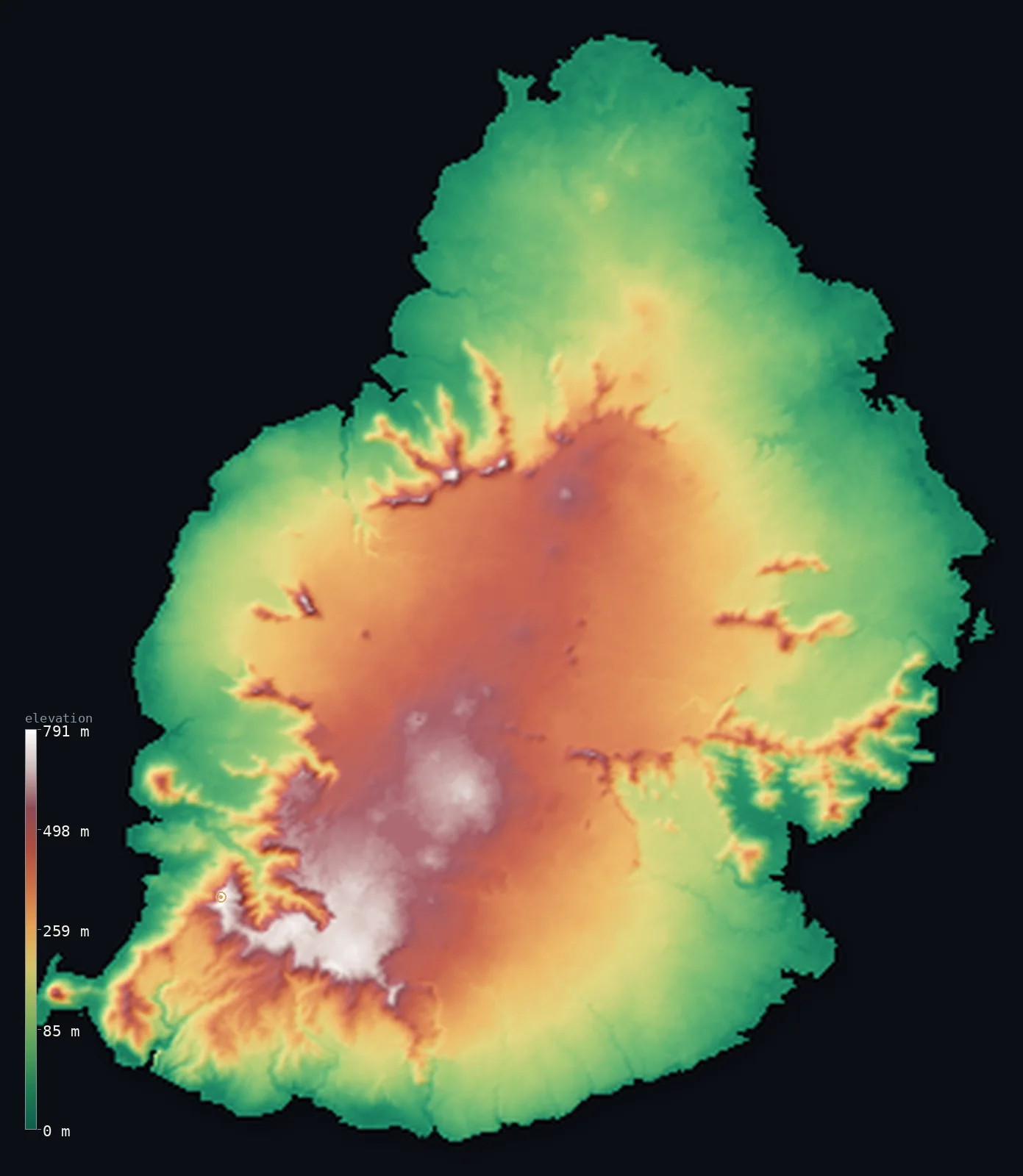
Mauritius’s highest point is Piton de la Petite Riviere Noire at 2,717 ft (828 m); its lowest is Indian Ocean at 0 ft (0 m); the mean elevation is 709 ft (216 m).
Mauritius is a volcanic Indian Ocean island east of Madagascar — but, unlike the young volcanoes of Cabo Verde and the Comoros, it is old and eroded, the worn remnant of a shield volcano. Its mountains are not a single range but broken rings of harder rock left standing around a central plateau, and its highest point, Piton de la Petite Rivière Noire, reaches only 2,717 ft (828 m), a worn summit in the southwest — less famous than the slightly lower Pieter Both, crowned by a balanced boulder, and Le Pouce above the capital. An almost continuous coral reef rings the island. Half of Mauritius lies below about 530 ft, its worn central heights lifting the mean above. (The outer island of Rodrigues is not shown in this view.)
- Highest point📚
- 2,717 ft828 m
- Mauritius's highest point is Piton de la Petite Rivière Noire (Little Black River Peak) at 2,717 ft (828 m), in the Black River Range of the southwest, within Black River Gorges National Park. Unlike the active volcanoes of Cabo Verde and the Comoros, it is an eroded remnant: Mauritius is the worn stump of an old shield volcano, its mountains not a single range but broken rings of harder rock left standing around a central plateau. The peak is less famous than the slightly lower Pieter Both and Le Pouce that loom over the capital.
- Lowest point📚
- 0 ft0 m
- Mauritius's lowest point is the Indian Ocean at sea level, around a coast almost entirely ringed by coral reef, enclosing a shallow lagoon. The volcanic main island rises from this coast through a ring of broken mountains to a central plateau — greener and gentler than the young volcanic archipelagos to its north and west.
- Mean elevation⚙
- 709 ft216 m
- Computed from the GLO-30 model, Mauritius's mean elevation is 709 ft (216 m) — lifted above the typical point by the central plateau and the broken mountain rings, so that half the island lies below about 528 ft (161 m). The coastal plain and the reef-fringed shore are the low majority; the eroded volcanic heights are the higher minority.
- Median elevation⚙
- 528 ft161 m
- Half of Mauritius lies below about 528 ft (161 m) — below the mean, because the island's height is in its central plateau and the broken rings of mountains around it, while a broad coastal plain rings the shore. Mauritius is the worn remnant of a shield volcano: its high ground is a ruin of harder rock, not a single towering peak.
- Elevation range📚
- 2,717 ft828 m
- From the reef-fringed Indian Ocean shore to Piton de la Petite Rivière Noire at 828 m, Mauritius's terrain climbs about 2,717 ft — a modest range, for Mauritius is an old, eroded island: no towering active cone, but a worn central plateau ringed by the broken stumps of ancient mountains.
- Official area📚
- 788 mi²2,040 km²
- Mauritius covers about 788 sq mi (2,040 sq km) — a volcanic Indian Ocean island east of Madagascar, its main island a central plateau ringed by three broken mountain ranges and encircled by coral reef, together with the outer dependency of Rodrigues, some 560 km to the east, and the far-flung Agalega and St. Brandon islands.
- Forest cover📚
- 19%
- About 19% of Mauritius is forested — remnants of native upland forest survive in the Black River Gorges of the mountainous southwest, while much of the island, once forested, was long ago cleared for sugar cane; it was the only home of the dodo, driven extinct in the 17th century.
Highest and lowest points
The highest point of Mauritius at 828 m - Piton de la Petite Riviere Noire (Little Black River Peak), in the Black River Range of the southwest main island, within Black River Gorges National Park. It is an eroded volcanic summit, interior; as an island nation Mauritius has no land borders.
source ↗Mauritius's lowest point is the Indian Ocean at sea level, around a coast almost entirely encircled by an offshore coral reef that encloses a shallow lagoon. The volcanic main island — the eroded remnant of a shield volcano — rises from this coast to a central plateau ringed by three broken mountain ranges: the Black River Range in the southwest, holding the high point, Piton de la Petite Rivière Noire; the Moka Range behind the capital, Port Louis, with Pieter Both and its balanced-boulder summit and Le Pouce; and the Grand Port Range in the southeast. Native upland forest survives in the Black River Gorges; the rest, once wooded — the island was the only home of the dodo — was long cleared for sugar cane. The country also includes the outer island of Rodrigues, about 560 km to the east, and the far-flung Agalega and St. Brandon islands; these outer dependencies are not shown in this view, which renders the main island of Mauritius.
source ↗Mauritius at a glance
Mauritius is the eroded remnant of a shield volcano - its mountains are not a single range but broken rings of harder rock left standing around a central plateau.
source ↗Its highest peak, Piton de la Petite Riviere Noire (828 m), is less famous than the slightly lower Pieter Both and Le Pouce that loom over the capital.
source ↗Pieter Both is crowned by a near-spherical boulder balanced on its narrow summit - one of the island's most recognisable landmarks.
source ↗Mauritius was the only known home of the dodo, the flightless bird driven extinct in the 17th century.
source ↗The country includes Rodrigues, about 560 km to the east, plus the far-flung Agalega and St. Brandon islands hundreds of kilometres away.
source ↗An almost continuous coral reef encircles the main island, enclosing a shallow lagoon around most of its coast.
source ↗
Elevation profile of Mauritius
The largest share of land, 38%, falls in the 0–100 m band, and 91% of the territory lies below 500 m (1,640 ft).
- below 500 m (1,640 ft)91%
- 500–1,000 m9%
Highest peaks of Mauritius
| Peak | Elevation | Range | Note |
|---|---|---|---|
| Piton de la Petite Riviere Noire↗ | 2,717 ft828 m | Black River Range (southwest) | Highest point of Mauritius, an eroded volcanic peak in Black River Gorges National Park. |
| Pieter Both↗ | 2,690 ft820 m | Moka Range (northwest) | The second-highest summit, famous for the boulder balanced on its peak above Port Louis. |
| Le Pouce↗ | 2,664 ft812 m | Moka Range (northwest) | The third-highest summit, a thumb-shaped peak overlooking Port Louis. |
Mauritius: the central plateau, the broken mountain rings, and the coast
The central plateau
The raised heart of the eroded volcano — a cooler upland holding towns like Curepipe and Vacoas, from which the broken mountain ranges rise around the rim.
The broken mountain rings
Not one range but three broken rings of harder rock left standing by erosion — the Black River Range in the southwest (with the high point), the Moka Range behind Port Louis (Pieter Both, Le Pouce), and the Grand Port Range in the southeast.
The coastal plain and reef
A broad coastal plain, long cleared for sugar cane, ringed almost entirely by an offshore coral reef enclosing a shallow lagoon — the low, warm edge where the capital Port Louis and the coastal towns lie.
How to read this map
Color shows elevation; the raised relief shows real terrain. On this map Mauritius reads as a low, green island with a raised centre — the mid-toned central plateau ringed by the broken browns of the eroded mountain rings (highest at Piton de la Petite Rivière Noire), falling to the low coastal plain and the reef-ringed shore.
Because the island is old and worn rather than sharply peaked, the 3D exaggeration brings out the plateau and its ring of ruined mountains; the ×N relief slider controls how much. Tap anywhere to read that point's exact elevation. (Distant Rodrigues is not shown in this view.)
City elevations in Mauritius
Mauritius's towns cluster on the central plateau and the coast — Port Louis, the capital, on the northwest coast, with Vacoas and Curepipe up on the cooler central plateau and coastal towns like Mahébourg in the southeast.
| City | Population | Elevation |
|---|---|---|
| Port Louiscapitalthe capital, on the northwest coast below the Moka Range ↗ | 155,226 | 16 ft5 m |
| Vacoason the central plateau ↗ | 115,289 | 1,263 ft385 m |
| Goodlandsin the north of the island ↗ | 21,063 | 144 ft44 m |
| Bel Air Rivière Sèche | 18,036 | 246 ft75 m |
| Mahébourgon the southeast coast, by the lagoon ↗ | 17,042 | 79 ft24 m |
| Chemin Grenieron the south coast ↗ | 12,457 | 259 ft79 m |
Elevation sampled at each city centre from the Copernicus GLO-30 model. Cities and population from GeoNames (CC-BY 4.0).
Mauritius in comparison
Mauritius's terrain rises 2,717 ft (828 m) from sea level to Piton de la Petite Riviere Noire — about 9% of the height of Mount Everest, the world's highest point at 29,032 ft (8,849 m).
- Madagascar's mean elevation is 1,778 ft — 1,070 ft higher; its high point, Maromokotro, reaches 9,436 ft (2,876 m), 6,719 ft above. Madagascar elevation map →
- Seychelles's mean elevation is 659 ft — 49 ft lower; its high point, Morne Seychellois, reaches 2,969 ft (905 m), 253 ft above. Seychelles elevation map →
Frequently asked questions
What is the highest point in Mauritius?
- Piton de la Petite Rivière Noire, 2,717 ft (828 m), in the Black River Range of the southwest - an eroded volcanic summit, not an active peak.
What is the average elevation of Mauritius?
- No standard source publishes one, so this page reports the mean computed from the Copernicus GLO-30 model, 709 ft (216 m) - lifted by the central plateau and mountains; about half the island lies below about 528 ft (161 m).
What is the lowest point in Mauritius?
- The Indian Ocean at sea level, around a coast ringed by coral reef and lagoon.
What are the main mountains of Mauritius?
- Broken rings of eroded rock around a central plateau - the Black River Range (with the high point, Piton de la Petite Rivière Noire), the Moka Range (Pieter Both, Le Pouce), and the Grand Port Range. Mauritius is the worn remnant of a shield volcano.
Is Mauritius just one island?
- No - the country also includes Rodrigues, about 560 km to the east, and the far-flung Agalega and St. Brandon islands. This map renders the main island of Mauritius.
Is this a topographic, relief, contour, or elevation map of Mauritius?
- They describe the same thing - terrain height. This page renders the island's actual elevation surface in interactive 3D and reports the statistics computed from it.
About this map
The terrain is rendered from the Copernicus GLO-30 digital elevation model (ESA), masked to the MUS-ADM0 boundary from geoBoundaries (gbOpen). Elevation statistics are computed directly from the model; peak names and researched facts are sourced and cited. See the methodology for the full pipeline.
Our area-weighted mean, computed from the Copernicus GLO-30 model, is 709 ft (216 m); no authority publishes a mean elevation (No authoritative published mean elevation). Mauritius is not a young, towering volcano like Cabo Verde or the Comoros, but the eroded remnant of an old shield volcano. Its mountains are not a single range but broken rings of harder rock left standing around a central plateau, and its highest point, Piton de la Petite Rivière Noire, is a worn summit in the Black River Range of the southwest — less famous than the slightly lower Pieter Both, crowned by a balanced boulder, and Le Pouce, that loom over the capital. Because the height is in this plateau and its ring of ruined mountains while a broad coastal plain rings the reef-fringed shore, the mean is lifted above the typical point and half of Mauritius lies below about 528 ft (161 m). The country also includes distant Rodrigues, some 560 km east, which is not shown in this view. No standard source publishes a mean elevation for Mauritius; the figure here is computed directly from the GLO-30 surface.
Surveyed national figures: official area · forest cover · high point.
Rendered from Copernicus GLO-30 (ESA, 2021 release), boundaries from geoBoundaries. Generated 2026-06-24.