Madagascar Elevation Map — Topographic & 3D Terrain
Explore the terrain of Madagascar in interactive 3D, built from Copernicus GLO-30 satellite elevation data — a vast island of central highlands, a steep eastern escarpment, and broad western plains. Drag to rotate, scroll to zoom, and tap any point to read its elevation.
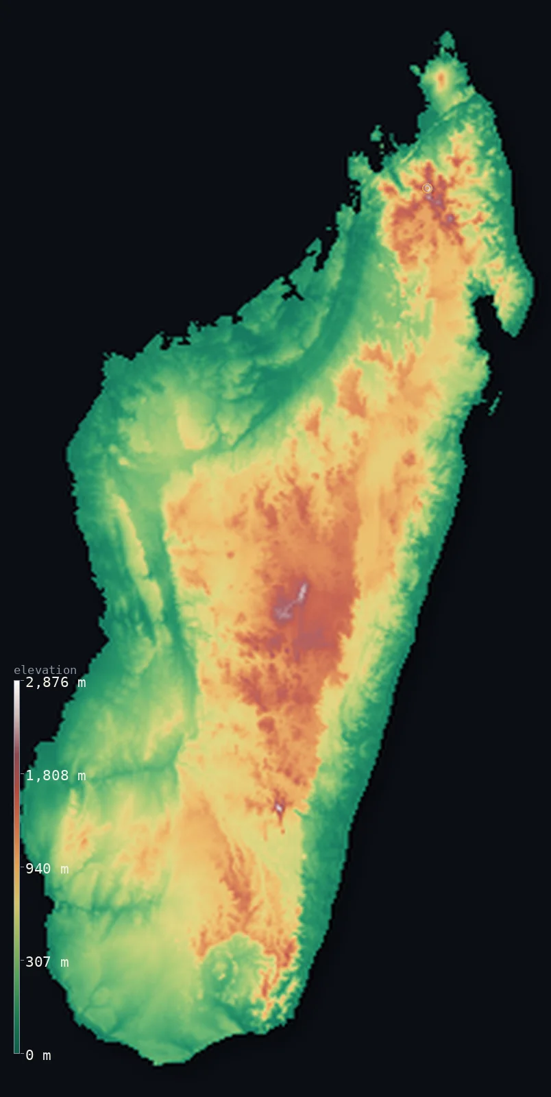
Madagascar’s highest point is Maromokotro at 9,436 ft (2,876 m); its lowest is Indian Ocean at 0 ft (0 m); the mean elevation is 1,778 ft (542 m).
A high spine runs the length of Madagascar, the fourth-largest island in the world. Set in the Indian Ocean off the southeastern coast of Africa, it is dominated by the Central Highlands — a long, high plateau of hills, ridges, and old volcanic massifs, mostly above 3,000 ft, rising to Maromokotro at 9,436 ft (2,876 m) in the north. From this high backbone the land falls steeply eastward, down a sharp escarpment to a narrow, wet eastern coast, and slopes more gradually westward through plateaus to broad, drier plains and the Mozambique Channel.
- Highest point📚
- 9,436 ft2,876 m
- Madagascar's highest point is Maromokotro at 9,436 ft (2,876 m), in the Tsaratanana Massif in the far north — an old volcanic highland, the highest of the ranges that rise from the island's Central Highlands. It stands well above the high plateau that forms the island's backbone, the roof of Madagascar.
- Lowest point📚
- 0 ft0 m
- Madagascar's lowest point is the sea at sea level, around the island's coasts — the narrow, wet eastern shore backed by its steep escarpment, and the broader, drier western and southern coasts along the Mozambique Channel.
- Mean elevation⚙
- 1,778 ft542 m
- Computed from the GLO-30 model, Madagascar's mean elevation is 1,778 ft (542 m) — a fairly high figure for an island, reflecting the dominance of the Central Highlands: a high plateau backbone runs the length of the island, lifting much of the interior well above the sea, with the coastal plains, wider in the west, lying low.
- Median elevation⚙
- 1,401 ft427 m
- Half of Madagascar lies below about 1,401 ft (427 m) — reflecting the balance of the island: the Central Highlands are high and cover much of the interior, but the coastal plains, especially the broad western lowlands, hold enough low ground to bring the middle down. The typical point is highland or its lower slopes.
- Elevation range📚
- 9,436 ft2,876 m
- From the sea to the summit of Maromokotro at 2,876 m, Madagascar's terrain climbs 9,436 ft — from the coasts up to the high volcanic massifs of the north, the rise concentrated in the Central Highlands that run the length of the island, steepest on the eastern side.
- Above 1,000 m (3,281 ft)⚙
- 17%
- About 17% of Madagascar rises above 1,000 m (3,281 ft) — the Central Highlands, the high plateau backbone running the length of the island. The coastal plains, broad in the west and narrow in the east, lie lower.
- Official area📚
- 226,658 mi²587,041 km²
- Madagascar covers about 226,700 sq mi (587,041 sq km) — the fourth-largest island in the world, in the Indian Ocean off southeastern Africa, dominated by the high Central Highlands, with a steep eastern escarpment to a narrow wet coast and broad plains sloping west to the Mozambique Channel.
- Forest cover📚
- 21%
- About 21% of Madagascar is forested — rainforest along the wet eastern escarpment, dry deciduous forest in the west, and the unique spiny forest of the arid south, though much of the highland interior is now open grassland; Madagascar's forests hold plants and animals found nowhere else on Earth.
Highest and lowest points
Madagascar's highest point is Maromokotro, 9,436 ft (2,876 m), in the Tsaratanana Massif in the far north of the island — an old, eroded volcanic highland, the highest of several massifs that rise from Madagascar's Central Highlands. These highlands, a long high plateau of hills, ridges, rice-terraced valleys, and worn volcanic ranges, run the length of the island and form its backbone and its heart, holding the capital, Antananarivo. Maromokotro is their highest summit — the roof of an island long isolated from any mainland, whose plants and animals evolved, like its terrain, into forms found nowhere else.
source ↗Madagascar's lowest point is the sea at sea level, around a coast of two very different characters. In the east, the Central Highlands drop steeply down a sharp escarpment to a narrow coastal plain — a wet, tropical shore of rainforest, lagoons, and beaches, backed almost at once by the rising highlands. In the west and south, the land slopes more gradually through plateaus to broader, drier coastal plains along the Mozambique Channel. The island's rivers reflect this tilt: short and fast down the eastern escarpment, long and meandering across the western lowlands to the channel.
source ↗Madagascar at a glance
Madagascar is the world's fourth-largest island, and broke away from India about 88-65 million years ago, letting its wildlife evolve in isolation.
source ↗As an island nation, Madagascar has no land borders at all - so its highest point, Maromokotro, is unambiguously its own.
source ↗A high plateau, mostly 800-1,800 m, runs the length of the island, so the capital Antananarivo sits at about 1,276 m despite the tropical latitude.
source ↗Maromokotro and the other highest summits are extinct volcanoes; the peak is so remote it was first climbed only in 1936.
source ↗Madagascar is called the 'Great Red Island' for the red lateritic soils that dominate its central highlands.
source ↗The eastern escarpment wrings rainforest out of the trade winds, while the southwest is so dry it supports a desert of endemic spiny succulents.
source ↗
Elevation profile of Madagascar
The largest share of land, 31%, falls in the 0–200 m band, with the land split almost evenly above and below 500 m (1,640 ft).
- below 500 m (1,640 ft)54%
- 500–1,000 m29%
- 1,000–2,000 m17%
- above 2,000 m (6,562 ft)<1%
Highest peaks of Madagascar
| Peak | Elevation | Range | Note |
|---|---|---|---|
| Maromokotro↗ | 9,436 ft2,876 m | Tsaratanana Massif (north) | Highest point of Madagascar, a volcanic summit at the far north of the island. |
| Pic Boby (Imarivolanitra)↗ | 8,720 ft2,658 m | Andringitra Massif (southeast) | The island's second-highest peak, in Andringitra National Park in the southeast. |
| Tsiafajavona↗ | 8,671 ft2,643 m | Ankaratra Massif (central) | The highest point of the volcanic Ankaratra Massif in the centre of the island, a major watershed divide. |
| Montagne d'Ambre (Ambohitra)↗ | 4,839 ft1,475 m | Far north (volcanic) | A volcanic massif at the northern tip, north of the Tsaratanana, known for its rainforest crater lakes. |
Madagascar: the Central Highlands, the eastern escarpment, and the western plains
The Central Highlands (the backbone)
The high heart of Madagascar is the Central Highlands — a long plateau of hills, ridges, terraced valleys, and worn old volcanic massifs running the length of the island, mostly above 900 m, rising to Maromokotro in the north. High, cooler, and holding the capital, Antananarivo, it is the island's backbone.
The eastern escarpment and coast
On the island's eastern side the highlands drop steeply down a sharp escarpment to a narrow coastal plain — a wet, tropical shore of rainforest, lagoons (the Canal des Pangalanes), and beaches, backed at once by the rising highlands. The steepest, wettest edge of the island.
The western and southern lowlands
West and south of the highlands the land slopes more gradually through lower plateaus to broad coastal plains along the Mozambique Channel — drier country of savanna, dry forest, and, in the arid south, unique spiny forest. Wider, lower, and drier than the east.
How to read this map
Color shows elevation; the raised relief shows real terrain. On this map Madagascar reads as a high-backboned island tilted west — the mid-to-high-toned Central Highlands running the length of the interior (highest in the northern Tsaratanana around Maromokotro), dropping sharply on the eastern side to a narrow low coast, and sloping more gently west through plateaus to the broad low plains along the Mozambique Channel.
The 3D relief is the actual GLO-30 elevation data, exaggerated vertically so the highlands, the eastern escarpment, and the western plains all show; the ×N relief slider controls how much. Tap anywhere to read that point's exact elevation.
City elevations in Madagascar
| City | Population | Elevation |
|---|---|---|
| Antananarivocapitalthe capital, high in the Central Highlands near the centre of the island ↗ | 1,349,501 | 4,173 ft1,272 m |
| Toamasinathe country's main port, on the narrow eastern coast below the rainforest escarpment ↗ | 345,107 | 26 ft8 m |
| Antsirabea highland town on the plateau south of the capital ↗ | 260,907 | 4,948 ft1,508 m |
| Mahajangaa northwestern port on the Mozambique Channel ↗ | 260,556 | 43 ft13 m |
| Fianarantsoaa highland city on the southern part of the plateau ↗ | 203,105 | 3,704 ft1,129 m |
| Toliaraa port in the arid southwest, on the Mozambique Channel ↗ | 178,725 | 26 ft8 m |
| Antsirananaa port near the island's northern tip ↗ | 136,959 | 197 ft60 m |
| Sambavaa town on the northeastern coast ↗ | 89,003 | 20 ft6 m |
| Tôlanaroa port on the southeastern coast ↗ | 71,258 | 95 ft29 m |
| Ambanjaa town in the northwest, near the Sambirano valley ↗ | 63,884 | 46 ft14 m |
Elevation sampled at each city centre from the Copernicus GLO-30 model. Cities and population from GeoNames (CC-BY 4.0).
Madagascar in comparison
Madagascar's terrain rises 9,436 ft (2,876 m) from sea level to Maromokotro — about 33% of the height of Mount Everest, the world's highest point at 29,032 ft (8,849 m).
- Mozambique's mean elevation is 1,161 ft — 617 ft lower; its high point, Monte Binga, reaches 7,992 ft (2,436 m), 1,444 ft below. Mozambique elevation map →
- Mauritius's mean elevation is 709 ft — 1,070 ft lower; its high point, Piton de la Petite Riviere Noire, reaches 2,717 ft (828 m), 6,719 ft below. Mauritius elevation map →
- Comoros's mean elevation is 1,617 ft — 161 ft lower; its high point, Mount Karthala, reaches 7,746 ft (2,361 m), 1,690 ft below. Comoros elevation map →
Frequently asked questions
What is the highest point in Madagascar?
- Maromokotro, 9,436 ft (2,876 m), in the Tsaratanana Massif in the far north — an old volcanic highland, the highest of the massifs rising from the island's Central Highlands.
What is the lowest point in Madagascar?
- The sea at sea level, around the coasts — a narrow wet eastern shore backed by a steep escarpment, and broader, drier western and southern plains along the Mozambique Channel.
What is the average elevation of Madagascar?
- Computed from the Copernicus GLO-30 model, the area-weighted mean is 1,778 ft (542 m) — fairly high for an island, because the Central Highlands, a high plateau backbone, run the length of the island, with the coastal plains lower.
What are the Central Highlands?
- Madagascar's high plateau backbone — a long belt of hills, ridges, terraced valleys, and old volcanic massifs running the length of the island above 900 m, rising to Maromokotro and holding the capital, Antananarivo.
Why is Madagascar's wildlife unique?
- The island has been isolated from any mainland for tens of millions of years, so its plants and animals — including the lemurs — evolved in isolation, and most are found nowhere else on Earth.
Is this a topographic, relief, contour, or elevation map of Madagascar?
- They describe the same thing — terrain height. This page renders the island's actual elevation surface in interactive 3D and reports the statistics computed from it.
About this map
The terrain is rendered from the Copernicus GLO-30 digital elevation model (ESA), masked to the MDG-ADM0 boundary from geoBoundaries (gbOpen). Elevation statistics are computed directly from the model; peak names and researched facts are sourced and cited. See the methodology for the full pipeline.
Our area-weighted mean, computed from the Copernicus GLO-30 model, is 1,778 ft (542 m); the figure commonly cited elsewhere is 2,018 ft (615 m) (CIA World Factbook). The computed figure sits below the commonly cited one because Madagascar holds more low ground than its highland reputation suggests: the broad western plains and the coastal lowlands all around occupy a large share of the island and pull the area-weighted average below the 800–1,800 m plateau. The median lies lower still, near 1,401 ft (427 m), a measure of how much of the island is low country.
Surveyed national figures: official area · forest cover · high point.
Rendered from Copernicus GLO-30 (ESA, 2021 release), boundaries from geoBoundaries. Generated 2026-06-24.