Mozambique Elevation Map — Topographic & 3D Terrain
Explore the terrain of Mozambique in interactive 3D, built from Copernicus GLO-30 satellite elevation data — a long, low Indian Ocean coast and coastal plain rising to interior highlands. Drag to rotate, scroll to zoom, and tap any point to read its elevation.
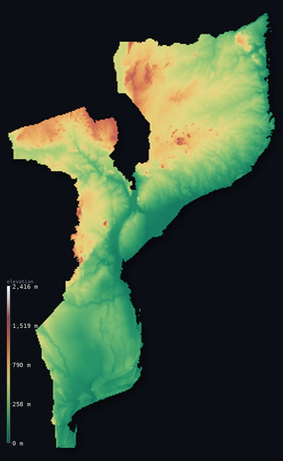
Mozambique’s highest point is Monte Binga at 7,992 ft (2,436 m); its lowest is Indian Ocean at 0 ft (0 m); the mean elevation is 1,161 ft (354 m).
Mozambique is a long, low country along the Indian Ocean. Its defining feature is its coast — one of the longest in Africa, running some 1,550 miles down the continent's southeastern edge — and behind it a broad, low coastal plain that covers much of the country, widest in the south and crossed by great rivers, above all the Zambezi, which reaches the sea through a vast delta. Inland the land rises to plateaus and scattered highlands, climbing highest in the west at Monte Binga, 7,992 ft (2,436 m), on the Zimbabwean border.
- Highest point📚
- 7,992 ft2,436 m
- Mozambique's highest point is Monte Binga at 7,992 ft (2,436 m), in the Chimanimani Mountains on the western border with Zimbabwe — part of the Eastern Highlands shared between the two countries, the highest ground in a country that is mostly low coastal plain and plateau. It rises far to the west, above the lowlands that make up the bulk of Mozambique.
- Lowest point📚
- 0 ft0 m
- Mozambique's lowest point is the Indian Ocean at sea level, along one of the longest coastlines in Africa — a low shore of beaches, dunes, mangroves, coral reefs, and the broad delta of the Zambezi, running the length of the country's eastern edge.
- Mean elevation⚙
- 1,161 ft354 m
- Computed from the GLO-30 model, Mozambique's mean elevation is 1,161 ft (354 m) — low, reflecting a country that is mostly low coastal plain: broad lowlands cover much of Mozambique — some 40% of it lies below 200 m — especially the south and the river valleys, with higher plateau and highlands only inland toward the west and north.
- Median elevation⚙
- 965 ft294 m
- Half of Mozambique lies below about 965 ft (294 m) — a low figure that fits the country's form: the broad coastal plain covers so much of Mozambique that most of the country lies close to the sea, with the interior plateaus and the western highlands the higher minority.
- Elevation range📚
- 7,992 ft2,436 m
- Mozambique's terrain spans about 7,990 ft in all, sea level to Monte Binga on the Zimbabwean border — but almost all of that height is packed into the far western corner: the great majority of the country is the low coastal plain, barely above the sea, with the rise held in the interior plateaus and the western highlands.
- Above 1,000 m (3,281 ft)⚙
- 4%
- Only about 4% of Mozambique rises above 1,000 m (3,281 ft) — just the interior plateaus and the western highlands on the Zimbabwe border. Almost the whole country is the low coastal plain and the lower interior, below that line.
- Official area📚
- 309,496 mi²801,590 km²
- Mozambique covers about 309,500 sq mi (801,590 sq km) — a country in southeastern Africa with one of the longest coastlines on the continent, mostly low coastal plain, rising inland to plateaus and, in the west, the highlands shared with Zimbabwe.
- Forest cover📚
- 43.7%
- About 44% of Mozambique is forested or wooded — miombo woodland and savanna across much of the interior, coastal forest, mangroves, and palm along the shore, and denser montane forest on the western highlands; much of the coastal plain is farmed.
Highest and lowest points
Mozambique's highest point is Monte Binga, 7,992 ft (2,436 m), in the Chimanimani Mountains on the western border with Zimbabwe. It is part of the Eastern Highlands, the mountainous strip shared between the two countries — and while Binga is the highest point of Mozambique, the range rises a little higher just across the border, at Zimbabwe's Nyangani (2,592 m), a short way north. Binga stands far to the west of the country, above the broad low coastal plains and plateaus that make up most of Mozambique — a high, green, misty corner of an otherwise low, warm, maritime land whose heart is its long Indian Ocean coast.
source ↗Mozambique's lowest point is the Indian Ocean at sea level, along one of the longest coastlines in Africa — some 2,500 km of beaches, dunes, mangrove creeks, coral reefs, and islands running the whole length of the country's eastern edge. Into it drain the great rivers of southeastern Africa, above all the Zambezi, which crosses Mozambique from the west and reaches the sea through a vast, low delta. The coastal plain behind this shore is broad — widest in the south, where it covers nearly the whole width of the country — and low, the defining lowland of Mozambique, from which the land rises only gradually inland.
source ↗Mozambique at a glance
From the rocky top of Monte Binga (2,436 m), on a very clear day, it is theoretically possible to glimpse the Indian Ocean about 190 km to the east.
source ↗Monte Binga is Mozambique's highest peak but only Zimbabwe's second-highest - its summit sits right on the shared border.
source ↗Nearly half of Mozambique is low coastal plain - the most extensive coastal lowland in southern Africa.
source ↗The Zambezi River crosses the country and is held back at Cahora Bassa, forming one of the largest reservoirs in Africa.
source ↗Mount Gorongosa rises alone from the plains like a 'frowning citadel' and feeds the famous wildlife floodplains of Gorongosa National Park.
source ↗A southern arm of the East African Rift Valley runs inland from the Zambezi toward Pungwe Bay.
source ↗
Elevation profile of Mozambique
The largest share of land, 40%, falls in the 0–200 m band, and 72% of the territory lies below 500 m (1,640 ft).
- below 500 m (1,640 ft)72%
- 500–1,000 m24%
- 1,000–2,000 m4%
- above 2,000 m (6,562 ft)<1%
Highest peaks of Mozambique
| Peak | Elevation | Range | Note |
|---|---|---|---|
| Monte Binga↗ | 7,992 ft2,436 m | Chimanimani Mountains (west-central border) | Highest point of Mozambique, a quartzite border summit shared with Zimbabwe. |
| Mount Namuli↗ | 7,936 ft2,419 m | Namuli Highlands (north, Zambezia) | The second-highest peak, an isolated massif in the northern highlands, source of the Lurio River. |
| Mount Gorongosa↗ | 6,112 ft1,863 m | central (isolated massif) | A granite massif rising abruptly from the central plains like a citadel, northeast of the Manica Plateau. |
| Manica Plateau (high ground)↗ | 4,921 ft1,500 m | Manica Plateau (west-central) | The plateau between the Save and Zambezi that rises westward toward the Eastern Highlands and Binga. |
| Lebombo Mountains (high ground)↗ | 2,067 ft630 m | Lebombo Mountains (far south) | A low ridge behind Maputo Bay, nowhere exceeding about 630 m. |
Mozambique: the coast, the interior plateaus, and the western highlands
The coast and coastal plain
Mozambique's defining feature is its long Indian Ocean coast and the broad, low coastal plain behind it — beaches, dunes, mangroves, coral islands, and the vast delta of the Zambezi. The plain is widest in the south, covering nearly the whole country there, and holds most of the population and the capital, Maputo. Low and warm, it is the heart of Mozambique.
The interior plateaus
Inland the coastal plain rises to plateaus — middling tableland, higher in the north and west, of savanna and woodland, stepping up from the lowland toward the highlands and the borders. The country's middle ground between the low coast and the high west.
The western highlands
In the west, on the Zimbabwean border, rise the highlands — the Chimanimani Mountains with Monte Binga (the high point) and other ranges, part of the Eastern Highlands shared with Zimbabwe. The highest, greenest, and coolest ground in the country, a mountainous western edge above the lowlands.
How to read this map
Color shows elevation; the raised relief shows real terrain. On this map Mozambique reads as a long low coast rising inland — a broad band of low green along the Indian Ocean and across the wide southern plains, with the delta of the Zambezi, rising gradually to the mid-toned interior plateaus and, in the west on the Zimbabwean border, the browns of the highlands around Monte Binga.
The 3D relief is the actual GLO-30 elevation data, exaggerated vertically so the low coast and the interior highlands both show; the ×N relief slider controls how much. Tap anywhere to read that point's exact elevation.
City elevations in Mozambique
Mozambique's cities line the coast and the rivers — Maputo (the capital) in the far south, Beira and Quelimane on the central coast, Nacala and Pemba in the north — with Tete on the Zambezi, Chimoio in the western highlands, and Lichinga and Gurúè up on the northern plateaus. Most sit low, on or near the Indian Ocean shore.
| City | Population | Elevation |
|---|---|---|
| Maputocapitalthe capital, on the coast in the far south ↗ | 1,254,837 | 213 ft65 m |
| Nampulain the north, on the interior plateau ↗ | 770,379 | 1,417 ft432 m |
| Beiraa central coastal port, near the Pungwe mouth ↗ | 687,764 | 10 ft3 m |
| Chimoioin the west, in the highlands near the Zimbabwe border ↗ | 422,046 | 2,323 ft708 m |
| Teteon the Zambezi in the northwest ↗ | 357,000 | 449 ft137 m |
| Quelimanea low coastal port near the Zambezi delta ↗ | 349,842 | 23 ft7 m |
| Lichingahigh on the northern Lichinga plateau, near Lake Malawi ↗ | 281,341 | 4,423 ft1,348 m |
| Nacalaa deep-water port on the northern coast ↗ | 239,808 | 440 ft134 m |
| Pembaa coastal city on a bay in the far north ↗ | 232,932 | 167 ft51 m |
| Gurúèin the northern highlands, tea country below Mount Namuli ↗ | 168,971 | 2,352 ft717 m |
Elevation sampled at each city centre from the Copernicus GLO-30 model. Cities and population from GeoNames (CC-BY 4.0).
Mozambique in comparison
Mozambique's terrain rises 7,992 ft (2,436 m) from sea level to Monte Binga — about 28% of the height of Mount Everest, the world's highest point at 29,032 ft (8,849 m).
- Zimbabwe's mean elevation is 3,192 ft — 2,031 ft higher; its high point, Mount Nyangani, reaches 8,504 ft (2,592 m), 512 ft above. Zimbabwe elevation map →
- Malawi's mean elevation is 3,104 ft — 1,942 ft higher; its high point, Sapitwa Peak (Mount Mulanje), reaches 9,849 ft (3,002 m), 1,857 ft above. Malawi elevation map →
- Tanzania's mean elevation is 3,340 ft — 2,178 ft higher; its high point, Kilimanjaro (Uhuru Peak), reaches 19,341 ft (5,895 m), 11,348 ft above. Tanzania elevation map →
Frequently asked questions
What is the highest point in Mozambique?
- Monte Binga, 7,992 ft (2,436 m), in the Chimanimani Mountains on the Zimbabwean border — part of the Eastern Highlands shared with Zimbabwe (whose Nyangani, just across the border, rises a little higher).
What is the lowest point in Mozambique?
- The Indian Ocean at sea level, along one of the longest coastlines in Africa — some 2,500 km of low shore, with the broad delta of the Zambezi.
What is the average elevation of Mozambique?
- Computed from the Copernicus GLO-30 model, the area-weighted mean is 1,161 ft (354 m) — low, because Mozambique is mostly a broad low coastal plain, with higher plateau and highlands only inland.
Is Mozambique flat?
- Mostly low — a broad coastal plain, widest in the south, covers much of the country, rising gradually inland to plateaus and, in the west, the highlands. The highest point, Monte Binga, is 2,436 m on the Zimbabwean border.
How long is Mozambique's coastline?
- Some 2,500 km along the Indian Ocean — one of the longest in Africa — a low shore of beaches, dunes, mangroves, coral reefs and islands, and the delta of the Zambezi.
Is this a topographic, relief, contour, or elevation map of Mozambique?
- They describe the same thing — terrain height. This page renders the country's actual elevation surface in interactive 3D and reports the statistics computed from it.
About this map
The terrain is rendered from the Copernicus GLO-30 digital elevation model (ESA), masked to the MOZ-ADM0 boundary from geoBoundaries (gbOpen). Elevation statistics are computed directly from the model; peak names and researched facts are sourced and cited. See the methodology for the full pipeline.
Our area-weighted mean, computed from the Copernicus GLO-30 model, is 1,161 ft (354 m); the figure commonly cited elsewhere is 1,132 ft (345 m) (CIA World Factbook). Most of Mozambique is low coastal plain — nearly half the country, widest in the south — with higher plateau and highlands only inland, so its area-weighted mean is low. The figure computed here from the Copernicus GLO-30 model, about 354 m, is essentially the 345 m cited by the CIA World Factbook.
Surveyed national figures: official area · forest cover · high point.
Rendered from Copernicus GLO-30 (ESA, 2021 release), boundaries from geoBoundaries. Generated 2026-06-24.
Bordering countries · 6
Mozambique shares a land border with these countries — open any one to compare its terrain and highest point.