Malawi Elevation Map — Topographic & 3D Terrain
Explore the terrain of Malawi in interactive 3D, built from Copernicus GLO-30 satellite elevation data — a high-plateau country along Lake Malawi in the East African Rift, rising to Mount Mulanje. Drag to rotate, scroll to zoom, and tap any point to read its elevation.
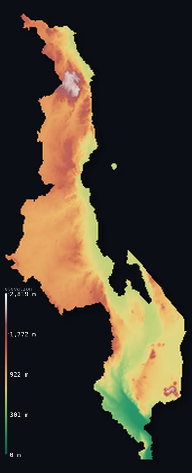
Malawi’s highest point is Sapitwa Peak (Mount Mulanje) at 9,849 ft (3,002 m); its lowest is Shire River at the Mozambique border at 121 ft (37 m); the mean elevation is 3,104 ft (946 m).
Malawi is a long, narrow country of Southern Africa, strung along Lake Malawi in the East African Rift. Down its eastern side runs the great lake — about 580 km long, its surface near 474 m — and, in the far south, the Shire valley falls to the country's lowest point. But the bulk of Malawi is high: broad plateaus of 1,000–1,400 m west of the lake, holding the capital Lilongwe, with higher massifs above them — the Nyika Plateau in the north and, in the south, Mount Mulanje, whose summit Sapitwa reaches 9,849 ft (3,002 m). So most of the country stands high while the rift trench lies deep: half of Malawi lies above about 3,380 ft, and its median elevation is actually greater than its mean.
- Highest point📚
- 9,849 ft3,002 m
- Malawi's highest point is Sapitwa Peak at 9,849 ft (3,002 m), the summit of the Mulanje Massif — a huge granite inselberg in the southeast that rises abruptly from plains below 1,000 m to a plateau of 1,800–2,500 m, so sharply it is nicknamed the 'island in the sky.' Sapitwa means 'unreachable' in Chichewa, and the peak is the highest point in south-central Africa.
- Lowest point📚
- 121 ft37 m
- Malawi's lowest point is about 121 ft (37 m), in the Shire valley of the far south, where the Shire River — draining Lake Malawi southward — falls steeply toward the Zambezi. This low trench is the exception in a mostly high country: from it the land climbs quickly to the plateaus and highlands that make up the bulk of Malawi.
- Mean elevation⚙
- 3,104 ft946 m
- Computed from the GLO-30 model, Malawi's mean elevation is 3,104 ft (946 m) — but this average is dragged down by two deep low places: Lake Malawi, whose surface lies near 474 m along the eastern Rift, and the Shire valley in the south. Most of the country stands higher: half of Malawi lies above about 3,383 ft (1,031 m), on the broad plateaus, so its median is actually greater than its mean.
- Median elevation⚙
- 3,383 ft1,031 m
- Half of Malawi lies above about 3,383 ft (1,031 m) — and, unusually, this midpoint is higher than the mean, because most of the country is high plateau (1,000–1,400 m) while a deep minority lies very low: Lake Malawi's surface near 474 m and the Shire valley below it. The high plateau is the true bulk of Malawi; the Rift Valley trench is what drags the average down below the median.
- Elevation range📚
- 9,728 ft2,965 m
- From the Shire valley at 37 m to Sapitwa Peak at 3,002 m, Malawi's terrain climbs about 9,730 ft — from the deep Rift Valley floor, across the broad plateaus, to the great granite inselberg of Mulanje in the southeast, the highest point in south-central Africa.
- Above 1,000 m (3,281 ft)⚙
- 52%
- About 52% of Malawi rises above 1,000 m (3,281 ft) — the broad central and northern plateaus and the higher massifs (the Nyika Plateau, the Zomba Plateau, Mount Mulanje). Only Lake Malawi, the Rift Valley, and the Shire valley lie well below.
- Above 2,000 m (6,562 ft)⚙
- 1%
- About 1% of Malawi rises above 2,000 m (6,562 ft) — only the highest massifs: the Nyika Plateau in the north and the peaks of Mount Mulanje in the south.
- Official area📚
- 45,747 mi²118,484 km²
- Malawi covers about 45,750 sq mi (118,484 sq km) — a long, narrow country of Southern Africa strung along Lake Malawi in the East African Rift: the great lake and its rift trench in the east, the broad plateaus (1,000–1,400 m) that make up the bulk of the country, and higher massifs — the Nyika Plateau in the north and Mount Mulanje (with Sapitwa) in the south.
- Forest cover📚
- 23%
- About 23% of Malawi is forested — miombo woodland across the plateaus, montane forest and grassland on the high massifs (including the endemic Mulanje cedar, found almost nowhere else on Earth), and wooded hills around Lake Malawi.
Highest and lowest points
The highest point of Malawi at 3,002 m - Sapitwa Peak, the summit of the Mulanje Massif, a large granite inselberg in the southeast about 65 km east of Blantyre. The massif rises sharply from plains below 1,000 m to a plateau of 1,800-2,500 m, so the summit coordinate must sit on the peak itself. It is interior, near but not on the Mozambique border.
source ↗Malawi's lowest point is about 37 m, in the Shire valley of the far south, where the Shire River — the outflow of Lake Malawi — falls steeply toward its meeting with the Zambezi. Malawi is a long, narrow country strung along the East African Rift, and its defining feature is Lake Malawi (called Lake Nyasa in Tanzania and Lago Niassa in Mozambique): about 580 km long, covering roughly a fifth of the country, one of the deepest lakes in the world and home to more fish species than any other. West of the lake spread the broad plateaus of 1,000–1,400 m that make up most of Malawi and hold the capital, Lilongwe; above them rise higher massifs — the Nyika Plateau in the north, and in the south the Zomba Plateau and Mount Mulanje, an inselberg rising over 2,000 m straight from the plains to Sapitwa, the highest point in south-central Africa. From the high plateau the land drops sharply to the rift floor and, in the south, to the low Shire valley — the one deep lowland in an otherwise high country.
source ↗Malawi at a glance
Lake Malawi covers about a fifth of the country and is one of the deepest lakes in the world, holding more fish species than any other lake.
source ↗Sapitwa Peak (3,002 m) on Mount Mulanje is the highest point in south-central Africa - its name means 'unreachable' in Chichewa.
source ↗Mount Mulanje is an inselberg - an isolated block rising over 2,000 m straight out of the surrounding plains, so abruptly it is nicknamed the 'island in the sky'.
source ↗Chambe Peak on Mulanje has the longest rock climb in Africa on its west face.
source ↗The Shire River, draining Lake Malawi south to the Zambezi, falls steeply through the Shire valley to the country's lowest point at about 37 m.
source ↗The endangered Mulanje cedar, found almost nowhere else on Earth, grows only on the Mulanje Massif and is Malawi's national tree.
source ↗
Elevation profile of Malawi
The largest share of land, 27%, falls in the 1,000–1,200 m band, and 87% of the territory lies above 500 m (1,640 ft).
- below 500 m (1,640 ft)13%
- 500–1,000 m35%
- 1,000–2,000 m51%
- above 2,000 m (6,562 ft)1%
Highest peaks of Malawi
| Peak | Elevation | Range | Note |
|---|---|---|---|
| Sapitwa Peak (Mount Mulanje)↗ | 9,849 ft3,002 m | Mulanje Massif (southeast) | Highest point of Malawi and of south-central Africa, the summit of the Mulanje inselberg. |
| Nganda Peak↗ | 8,547 ft2,605 m | Nyika Plateau (north) | The high point of the broad Nyika Plateau in the far north, a rolling montane grassland. |
| Chambe Peak↗ | 8,389 ft2,557 m | Mulanje Massif (southeast) | A peak of the Mulanje Massif whose west face is the longest rock climb in Africa. |
Malawi: Lake Malawi and the Rift, the plateaus, and the highlands
Lake Malawi and the Rift Valley
The great trench of Lake Malawi — about 580 km long, its surface near 474 m — fills the eastern side of the country along the East African Rift, draining south by the Shire River to the country's lowest point. (The lake is called Nyasa in Tanzania, Niassa in Mozambique.)
The plateaus
The broad central and northern plateaus, mostly 1,000–1,400 m, that make up the bulk of Malawi west of the lake, holding the capital Lilongwe.
The highlands
Higher massifs rising above the plateaus — the Nyika Plateau in the north, and the Shire Highlands, Zomba Plateau, and Mount Mulanje (with Sapitwa) in the south.
How to read this map
Color shows elevation; the raised relief shows real terrain. On this map Malawi reads as a high country beside a deep trench — the broad mid-toned plateaus filling most of it, the blue of Lake Malawi and its rift dropping low along the east, and the high browns of the massifs standing above the plateau (Mount Mulanje with Sapitwa in the south, the Nyika Plateau in the north).
The rift trench and the massifs are the extremes; because the plateau bulk sits high, the 3D exaggeration brings out both. The ×N relief slider controls how much. Tap anywhere to read that point's exact elevation.
City elevations in Malawi
Malawi's cities lie along the plateaus and the lakeshore — Lilongwe, the capital, on the central plateau, and Blantyre, the commercial centre, in the southern Shire Highlands, with Mzuzu in the north near the Nyika Plateau and lakeshore towns like Karonga, Salima, Nkhotakota, and Mangochi along Lake Malawi.
| City | Population | Elevation |
|---|---|---|
| Lilongwecapitalthe capital, on the central plateau ↗ | 1,115,815 | 3,458 ft1,054 m |
| Blantyrethe commercial centre, in the southern Shire Highlands ↗ | 902,588 | 3,406 ft1,038 m |
| Mzuzuin the north, below the Nyika Plateau ↗ | 249,564 | 4,163 ft1,269 m |
| Karongaon the northern lakeshore of Lake Malawi ↗ | 69,486 | 1,578 ft481 m |
| Kasunguon the central plateau ↗ | 66,152 | 3,432 ft1,046 m |
| Mangochiin the south, at Lake Malawi's outflow to the Shire ↗ | 60,338 | 1,588 ft484 m |
| Salimaon the central lakeshore ↗ | 41,492 | 1,677 ft511 m |
| Liwonde | 41,077 | 1,637 ft499 m |
| Dedzain the central highlands near the Mozambique border ↗ | 34,882 | 5,256 ft1,602 m |
| Nkhotakotaon the central lakeshore ↗ | 31,974 | 1,611 ft491 m |
Elevation sampled at each city centre from the Copernicus GLO-30 model. Cities and population from GeoNames (CC-BY 4.0).
Malawi in comparison
Malawi's terrain rises 9,728 ft (2,965 m) from Shire River at the Mozambique border (121 ft (37 m)) to Sapitwa Peak (Mount Mulanje) — about 34% of the height of Mount Everest, the world's highest point at 29,032 ft (8,849 m).
- Mozambique's mean elevation is 1,161 ft — 1,942 ft lower; its high point, Monte Binga, reaches 7,992 ft (2,436 m), 1,857 ft below. Mozambique elevation map →
- Zambia's mean elevation is 3,671 ft — 568 ft higher; its high point, Mafinga Central, reaches 7,674 ft (2,339 m), 2,175 ft below. Zambia elevation map →
- Tanzania's mean elevation is 3,340 ft — 236 ft higher; its high point, Kilimanjaro (Uhuru Peak), reaches 19,341 ft (5,895 m), 9,491 ft above. Tanzania elevation map →
Frequently asked questions
What is the highest point in Malawi?
- Sapitwa Peak, 9,849 ft (3,002 m), the summit of the Mulanje Massif in the southeast - a granite inselberg nicknamed the 'island in the sky,' and the highest point in south-central Africa.
What is the average elevation of Malawi?
- Computed from the Copernicus GLO-30 model, the area-weighted mean is 3,104 ft (946 m) - dragged down by Lake Malawi and the Rift Valley. Most of the country is higher: half lies above about 3,383 ft (1,031 m), so the median exceeds the mean.
What is the lowest point in Malawi?
- About 121 ft (37 m), in the Shire valley of the far south, where the Shire River falls toward the Zambezi.
How high is Lake Malawi?
- Its surface lies near 474 m, in the East African Rift along the eastern side of the country. Called Lake Nyasa in Tanzania and Lago Niassa in Mozambique, it covers about a fifth of Malawi and is one of the deepest lakes in the world.
Where are the mountains in Malawi?
- On the high massifs above the plateaus - the Nyika Plateau in the north, and in the south the Zomba Plateau and Mount Mulanje, whose summit Sapitwa is the country's highest point.
Is this a topographic, relief, contour, or elevation map of Malawi?
- They describe the same thing - terrain height. This page renders Malawi's actual elevation surface in interactive 3D and reports the statistics computed from it.
About this map
The terrain is rendered from the Copernicus GLO-30 digital elevation model (ESA), masked to the MWI-ADM0 boundary from geoBoundaries (gbOpen). Elevation statistics are computed directly from the model; peak names and researched facts are sourced and cited. See the methodology for the full pipeline.
Our area-weighted mean, computed from the Copernicus GLO-30 model, is 3,104 ft (946 m); the figure commonly cited elsewhere is 2,556 ft (779 m) (CIA World Factbook). Malawi is a high-plateau country split by a great rift. Down its eastern side runs the trench of Lake Malawi — about 580 km long, its surface near 474 m — part of the East African Rift, and in the far south the Shire valley falls lower still, to the country's lowest point. But the bulk of Malawi is high: broad plateaus of 1,000–1,400 m west of the lake, holding the capital Lilongwe, with higher massifs above them — the Nyika Plateau in the north and, in the south, the Zomba Plateau and the great granite inselberg of Mount Mulanje, crowned by Sapitwa. Because the high plateau is the true bulk while the rift and the lake are a deep low minority, Malawi's median is higher than its mean: half the country lies above about 3,383 ft (1,031 m), and it is the rift trench that drags the average below that. The mean here is computed directly from the GLO-30 surface; a lower figure is sometimes cited elsewhere.
Surveyed national figures: official area · forest cover · high point.
Rendered from Copernicus GLO-30 (ESA, 2021 release), boundaries from geoBoundaries. Generated 2026-06-24.
Bordering countries · 3
Malawi shares a land border with these countries — open any one to compare its terrain and highest point.