Zambia Elevation Map — Topographic & 3D Terrain
Explore the terrain of Zambia in interactive 3D, built from Copernicus GLO-30 satellite elevation data — a high landlocked plateau broken by great river valleys and the northern swamps. Drag to rotate, scroll to zoom, and tap any point to read its elevation.
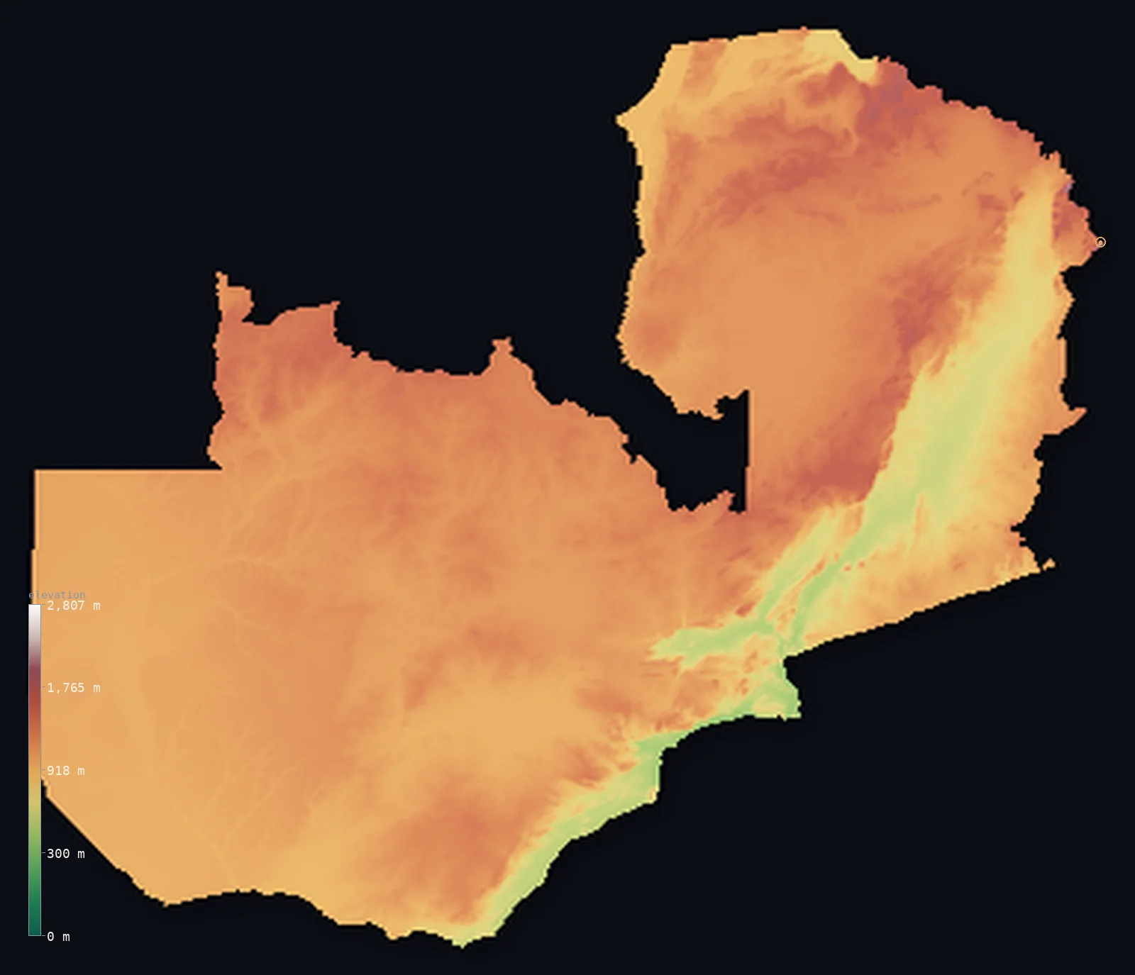
Zambia’s highest point is Mafinga Central at 7,674 ft (2,339 m); its lowest is Zambezi River at 1,079 ft (329 m); the mean elevation is 3,671 ft (1,119 m).
Zambia is a high plateau country. Landlocked in the heart of south-central Africa, most of it is a broad, high tableland lying between about 3,000 and 5,000 ft — uplifted, gently rolling plateau that slopes away toward the southwest. This plateau is broken by great valleys: the Zambezi along the southern border, where it thunders over Victoria Falls; the Kafue and the Luangwa, the Zambezi's two great tributaries; and, in the far north, the rift trench holding the southern tip of Lake Tanganyika. The highest ground is in the northeast, where the Mafinga Hills reach Mafinga Central at 7,674 ft (2,339 m) on the Malawi border. Even Zambia's lowest point stands above 1,000 ft.
- Highest point📚
- 7,674 ft2,339 m
- Zambia's highest point is Mafinga Central at 7,674 ft (2,339 m), in the Mafinga Hills on the northeastern border with Malawi — a rugged plateau of hills rather than a dramatic peak, the highest of the high ground that gathers in the country's northeast. Its near-twin, Mafinga South (2,337 m), stands just 2 m lower on the same ridge; a 2014 survey settled which is higher. The Luangwa River rises here, in the hills that crown the country.
- Lowest point📚
- 1,079 ft329 m
- Zambia's lowest point is the Zambezi River where it leaves the country at 1,079 ft (329 m) — and it is a striking measure of how high Zambia sits that even this, the lowest ground in the whole country, lies above 1,000 ft. Landlocked Zambia has no low coastal ground at all: it is a high plateau throughout, and its lowest point is simply where its greatest river flows out toward the Indian Ocean.
- Mean elevation⚙
- 3,671 ft1,119 m
- Computed from the GLO-30 model, Zambia's mean elevation is 3,671 ft (1,119 m). That figure sits high because Zambia barely descends from its plateau: a raised tableland above 1,000 m fills the country, cut only by the trenches of the Zambezi, Kafue, and Luangwa and the northern lake valleys, and rising in the northeast to the Mafinga Hills.
- Median elevation⚙
- 3,757 ft1,145 m
- Half of Zambia lies above about 3,757 ft (1,145 m) — a high median that in fact sits above the mean, because the plateau is so dominant that it is the low river valleys and northern swamps, not the uplands, that pull the average down. Most of the land is high tableland; the valleys and swamps are its main lower ground, the northeastern hills its higher.
- Elevation range📚
- 6,594 ft2,010 m
- Zambia's full vertical span is about 6,600 ft — but that figure is the work of just two outliers: the Zambezi, which has cut down to 329 m where it leaves the country, and the Mafinga Hills, which rise to 2,339 m in the far northeast. Away from those two extremes, the country barely leaves its plateau.
- Above 1,000 m (3,281 ft)⚙
- 82%
- About 82% of Zambia rises above 1,000 m (3,281 ft) — which is to say most of the country, since Zambia is a high plateau throughout. The lower ground is confined to the river valleys — the Zambezi, Kafue, and Luangwa trenches — and the northern lake basins.
- Official area📚
- 290,587 mi²752,618 km²
- Zambia covers about 290,600 sq mi (752,618 sq km) — a large, landlocked country in south-central Africa, mostly a high plateau, broken by the valleys of the Zambezi and its tributaries and the northern swamps, bordered by eight countries.
- Forest cover📚
- 60.3%
- About 60% of Zambia is forested or wooded — much of the plateau carries miombo woodland and savanna, with swamp and floodplain grassland in the north and west and patches of montane forest on the northeastern hills.
Highest and lowest points
Zambia's highest point is Mafinga Central, 7,674 ft (2,339 m), in the Mafinga Hills on the northeastern border with Malawi. It is a rugged upland — a plateau of hills rather than a single peak — and its near-twin Mafinga South, at 2,337 m, rises just 2 m lower on the same ridge, the two so close that a 2014 survey was needed to settle which is higher. These hills, part of the watershed dividing the Zambezi and Lake Malawi basins, are the source of the Luangwa River, which rises here before flowing southwest down its great rift valley. Away from this northeastern high ground, the highest point elsewhere in Zambia is Mount Mumpu (1,892 m), the tallest free-standing mountain in the country, at the western end of the Muchinga Mountains — a peak so distinct that the border of the Congo Pedicle was drawn around it. But it is the Mafinga Hills, in the far northeast, that crown the plateau.
source ↗Zambia's lowest point is the Zambezi River where it leaves the country, at about 1,079 ft (329 m) above sea level — and even this, the lowest ground in all of Zambia, stands above 1,000 ft, a striking sign of how high the country sits. Landlocked and far from any sea, Zambia is a high plateau from end to end, without a scrap of truly low ground. Its waters drain two ways across a continental divide that runs along its northern border: the north toward the Congo and the Atlantic, by way of the Luapula and Lake Tanganyika; and the rest toward the Zambezi and the Indian Ocean, gathered by the Kafue and the Luangwa and carried south and east past Victoria Falls.
source ↗Zambia at a glance
The Luangwa, one of Zambia's great rivers, rises in the same Mafinga Hills that hold the country's summit.
source ↗Victoria Falls (Mosi-oa-Tunya), where the Zambezi drops about 100 m into a mile-wide chasm on the Zambia–Zimbabwe border, is one of the world's largest waterfalls and a UNESCO World Heritage Site.
source ↗Lake Tanganyika, the world's second-deepest freshwater lake, reaches into Zambia's far north; the country also holds Lake Bangweulu and its vast swamps and shares Lake Mweru with the DR Congo.
source ↗Zambia sits on the continental divide between the Congo and Zambezi basins — the Congo draining north to the Atlantic, the Zambezi south and east to the Indian Ocean — with the watershed running along the DR Congo border and the Muchinga Mountains.
source ↗The Luangwa Valley is a southern arm of the Great Rift Valley — a deep rift trough shadowed by the Muchinga Escarpment, and one of Africa's great wildlife regions (South Luangwa National Park).
source ↗The Barotse Floodplain on the upper Zambezi floods each year to about 25 km wide, dominating life in western Zambia; the Kuomboka ceremony marks the retreat to higher ground.
source ↗The Copperbelt of northern Zambia is one of the world's major copper-mining regions and holds much of the country's population, alongside the capital, Lusaka.
source ↗The Kafue is the longest river flowing entirely within Zambia, rising on the Copperbelt and draining the Lukanga Swamp and the Kafue Flats before dropping to the Zambezi.
source ↗Even Zambia's lowest point — the Zambezi at 329 m — stands above 300 m; the country is a high plateau throughout.
source ↗
Elevation profile of Zambia
The largest share of land, 47%, falls in the 1,000–1,200 m band, and 98% of the territory lies above 500 m (1,640 ft).
- below 500 m (1,640 ft)2%
- 500–1,000 m17%
- 1,000–2,000 m82%
- above 2,000 m (6,562 ft)<1%
Highest peaks of Zambia
| Peak | Elevation | Range | Note |
|---|---|---|---|
| Mafinga Central↗ | 7,674 ft2,339 m | Mafinga Hills (Kipengere) | Highest point of Zambia, on the Malawian border in the northeast. |
| Mafinga South↗ | 7,667 ft2,337 m | Mafinga Hills (Kipengere) | A second summit on the Mafinga ridge, only about 2 m lower than Mafinga Central. |
| Mwanda Peak↗ | 7,047 ft2,148 m | Nyika Plateau | On the Nyika Plateau near the Malawi border, in the thin northeastern arm of Eastern Province. |
| Mount Mumpu↗ | 6,207 ft1,892 m | Muchinga Mountains (western end) | The tallest free-standing mountain in Zambia, at the western end of the Muchinga Mountains in Central Province and the highest point away from the eastern border region; the Congo Pedicle border was drawn around it. |
Zambia: the central plateau, the great river valleys, and the northern swamps
The central plateau
Most of Zambia is a high plateau, 3,000–5,000 ft (about 1,000–1,500 m), of uplifted planation surfaces sloping generally toward the southwest. The population concentrates around Lusaka in the south (itself about 4,200 ft) and the Copperbelt in the north, a major copper-mining region; the plateau is open miombo woodland and savanna.
The great valleys and the rift
The plateau is broken by huge valleys. The Zambezi runs along the southern border, deep and wide, with Victoria Falls and Lake Kariba; its two great tributaries are the Kafue (the longest river wholly within Zambia, rising on the Copperbelt and crossing the Kafue Flats wetlands) and the Luangwa (occupying the western section of the Great Rift Valley, a deep rift trough about 800 km long). Lake Tanganyika lies some 600 m below the plateau in a rift valley at the country's northern tip.
The northern plains, swamps, and floodplains
The north is very flat, with broad plains and great wetlands: the Bangweulu swamp complex (Lake Bangweulu, drained by the Luapula toward the Congo, home to the shoebill and the endemic black lechwe), and, in the west, the Barotse Floodplain on the upper Zambezi — about 5,500 km², flooding from December to June and reaching some 25 km wide, the second-largest wetland in Zambia.
How to read this map
Color shows elevation; the raised relief shows real terrain. On this map Zambia reads as a high plateau cut by river trenches — a broad expanse of mid-toned high tableland filling most of the country, scored by the darker low lines of the Zambezi along the south (with Victoria Falls and Lake Kariba), the Kafue through the centre, and the Luangwa in its long rift valley in the east, with the northern lake basins and the higher browns of the Mafinga Hills in the northeast.
The 3D relief is the actual GLO-30 elevation data, exaggerated vertically so the plateau and its valleys both show; the ×N relief slider controls how much. Tap anywhere to read that point's exact elevation.
City elevations in Zambia
Zambia's cities sit on the high plateau — Lusaka, the capital, in the south-centre, Kitwe on the Copperbelt in the north, Livingstone by Victoria Falls in the south, and regional centres like Kabwe, Chipata, Solwezi, Kasama, Mansa, and Mongu spread across the country. Mongu sits by the Barotse Floodplain in the west; all lie high, on the plateau.
| City | Population | Elevation |
|---|---|---|
| Lusakacapitalthe capital, on the plateau in the south-centre ↗ | 2,212,301 | 4,186 ft1,276 m |
| Kitweon the Copperbelt, the northern copper-mining region ↗ | 665,961 | 4,012 ft1,223 m |
| Chipatain the far east, near Malawi ↗ | 327,059 | 3,763 ft1,147 m |
| Solweziin the northwest ↗ | 301,370 | 4,521 ft1,378 m |
| Kabwein the central plateau ↗ | 288,598 | 3,894 ft1,187 m |
| Kasamain the north ↗ | 179,636 | 4,551 ft1,387 m |
| Livingstonein the south, beside Victoria Falls on the Zambezi ↗ | 178,361 | 3,159 ft963 m |
| Mansain the north, in Luapula ↗ | 170,965 | 3,976 ft1,212 m |
| Monguin the west, by the Barotse Floodplain on the upper Zambezi ↗ | 111,450 | 3,333 ft1,016 m |
Elevation sampled at each city centre from the Copernicus GLO-30 model. Cities and population from GeoNames (CC-BY 4.0).
Zambia in comparison
Zambia's terrain rises 6,594 ft (2,010 m) from Zambezi River (1,079 ft (329 m)) to Mafinga Central — about 23% of the height of Mount Everest, the world's highest point at 29,032 ft (8,849 m).
- Zimbabwe's mean elevation is 3,192 ft — 479 ft lower; its high point, Mount Nyangani, reaches 8,504 ft (2,592 m), 830 ft above. Zimbabwe elevation map →
- Democratic Republic of the Congo's mean elevation is 2,244 ft — 1,427 ft lower; its high point, Margherita Peak (Mount Stanley), reaches 16,762 ft (5,109 m), 9,088 ft above. Democratic Republic of the Congo elevation map →
- Tanzania's mean elevation is 3,340 ft — 331 ft lower; its high point, Kilimanjaro (Uhuru Peak), reaches 19,341 ft (5,895 m), 11,667 ft above. Tanzania elevation map →
- Malawi's mean elevation is 3,104 ft — 568 ft lower; its high point, Sapitwa Peak (Mount Mulanje), reaches 9,849 ft (3,002 m), 2,175 ft above. Malawi elevation map →
- Angola's mean elevation is 3,402 ft — 269 ft lower; its high point, Mount Moco (Morro de Môco), reaches 8,596 ft (2,620 m), 922 ft above. Angola elevation map →
Frequently asked questions
What is the highest point in Zambia?
- Mafinga Central, 7,674 ft (2,339 m), in the Mafinga Hills on the Malawi border in the northeast — a rugged upland (its near-twin Mafinga South is just 2 m lower), the source of the Luangwa River.
What is the lowest point in Zambia?
- The Zambezi River where it leaves the country, at 1,079 ft (329 m) — and even this, Zambia's lowest ground, stands above 1,000 ft, as the country is a high plateau throughout.
What is the average elevation of Zambia?
- Computed from the Copernicus GLO-30 model, the area-weighted mean is 3,671 ft (1,119 m) — high, because Zambia is essentially one great elevated plateau, broken only by its river valleys and northern swamps.
Is Zambia mountainous?
- Not really — it is a high plateau rather than a mountainous country, with the highest ground gathered in the northeastern Mafinga Hills (2,339 m). Most of Zambia is rolling high tableland, broken by the deep valleys of the Zambezi, Kafue, and Luangwa.
Where is Victoria Falls?
- On the Zambezi River along Zambia's southern border with Zimbabwe, in the country's south — where the river drops about 100 m into a mile-wide chasm, one of the world's largest waterfalls, shared between the two countries.
Is this a topographic, relief, contour, or elevation map of Zambia?
- They describe the same thing — terrain height. This page renders the country's actual elevation surface in interactive 3D and reports the statistics computed from it.
About this map
The terrain is rendered from the Copernicus GLO-30 digital elevation model (ESA), masked to the ZMB-ADM0 boundary from geoBoundaries (gbOpen). Elevation statistics are computed directly from the model; peak names and researched facts are sourced and cited. See the methodology for the full pipeline.
Our area-weighted mean, computed from the Copernicus GLO-30 model, is 3,671 ft (1,119 m); the figure commonly cited elsewhere is 3,734 ft (1,138 m) (CIA World Factbook). Almost all of Zambia is a high plateau, generally 1,000-1,600 m, cut only by the deep Zambezi and Luangwa valleys, so its mean elevation is high; the page reports the area-weighted figure computed from the Copernicus GLO-30 model.
Surveyed national figures: official area · forest cover · high point.
Rendered from Copernicus GLO-30 (ESA, 2021 release), boundaries from geoBoundaries. Generated 2026-07-08.
Bordering countries · 8
Zambia shares a land border with these countries — open any one to compare its terrain and highest point.
- Angola↑ Mount Moco (Morro de Môco), 2,620 m
- Botswana↑ Monalanong Hill, 1,495 m
- Democratic Republic of the Congo↑ Margherita Peak (Mount Stanley), 5,109 m
- Malawi↑ Sapitwa Peak (Mount Mulanje), 3,002 m
- Mozambique↑ Monte Binga, 2,436 m
- Namibia↑ Konigstein (Brandberg), 2,573 m
- Tanzania↑ Kilimanjaro (Uhuru Peak), 5,895 m
- Zimbabwe↑ Mount Nyangani, 2,592 m