Zimbabwe Elevation Map — Topographic & 3D Terrain
Explore the terrain of Zimbabwe in interactive 3D, built from Copernicus GLO-30 satellite elevation data — a high central plateau, the Highveld, between the Zambezi and the Limpopo. Drag to rotate, scroll to zoom, and tap any point to read its elevation.
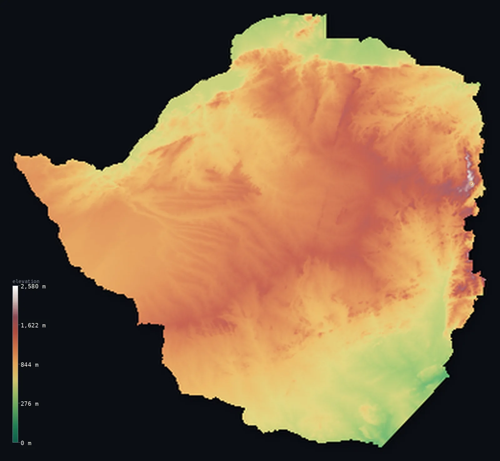
Zimbabwe’s highest point is Mount Nyangani at 8,504 ft (2,592 m); its lowest is Junction of the Runde and Save rivers at 531 ft (162 m); the mean elevation is 3,192 ft (973 m).
Zimbabwe is a country built on a high plateau. Its heart is the Highveld — a broad ridge of high ground running southwest to northeast across the centre of the country, mostly above 3,900 ft, dividing the land and shedding its rivers north and south. Lower plateau, the Middleveld and Lowveld, steps down on either side toward the great border rivers: the Zambezi in the north, where it plunges over Victoria Falls, and the Limpopo in the south. Along the eastern border with Mozambique rise the Eastern Highlands, the country's highest ground, reaching Nyangani at 8,504 ft (2,592 m).
- Highest point📚
- 8,504 ft2,592 m
- Zimbabwe's highest point is Nyangani at 8,504 ft (2,592 m), in the Eastern Highlands along the border with Mozambique — a green, misty, mountainous strip that is the highest and wettest ground in the country, in sharp contrast to the plateau interior. Nyangani is the high point of these highlands, well above the Highveld plateau that makes up the bulk of Zimbabwe.
- Lowest point📚
- 531 ft162 m
- Zimbabwe's lowest point is where the Runde (Save) river system leaves the country in the southeast, at about 531 ft (162 m) — in the hot, low Lowveld, the lowest and driest corner of a country that is otherwise high plateau. Zimbabwe is landlocked; its rivers drain to the Zambezi and the Limpopo, and on toward the Indian Ocean.
- Mean elevation⚙
- 3,192 ft973 m
- Computed from the GLO-30 model, Zimbabwe's mean elevation is 3,192 ft (973 m) — high, the mark of a country that is nearly all plateau: the central Highveld and the Middleveld hold most of the land well above the sea, only the Lowveld margins and the river valleys lie low, and the Eastern Highlands rise higher still.
- Median elevation⚙
- 3,343 ft1,019 m
- Half of Zimbabwe lies above about 3,343 ft (1,019 m) — a high median reflecting the plateau's dominance: high and middle veld cover so much of the country that its midpoint sits up on the tableland, only the low Lowveld and the deep river valleys falling below.
- Elevation range📚
- 7,972 ft2,430 m
- Zimbabwe's whole relief spans about 7,970 ft, from the Lowveld floor at the Runde to Nyangani in the Eastern Highlands — but the country is really a matter of plateau levels: the high Highveld, the stepped-down Middleveld and Lowveld, and the Eastern Highlands rising sharply along the Mozambican border.
- Above 1,000 m (3,281 ft)⚙
- 53%
- About 53% of Zimbabwe rises above 1,000 m (3,281 ft) — the central Highveld and much of the Middleveld, the high plateau country that covers most of the land. The Lowveld of the south and southeast and the river valleys lie lower.
- Official area📚
- 150,872 mi²390,757 km²
- Zimbabwe covers about 150,900 sq mi (390,757 sq km) — a landlocked country in southern Africa, dominated by the high central plateau of the Highveld, stepping down to lower veld on either side, between the Zambezi in the north and the Limpopo in the south, with the Eastern Highlands along the Mozambican border.
- Forest cover📚
- 45.3%
- About 45% of Zimbabwe is forested or wooded — miombo and mopane woodland and savanna across much of the plateau, with denser evergreen and montane forest in the wetter Eastern Highlands, and drier bush in the low southeast.
Highest and lowest points
Zimbabwe's highest point is Nyangani, 8,504 ft (2,592 m), in the Eastern Highlands along the border with Mozambique. These highlands — a narrow strip of green, misty mountains running along the eastern frontier, including the Nyanga, Bvumba, and Chimanimani ranges — are the highest and wettest part of the country, a dramatic contrast to the dry plateau interior. Nyangani is their summit. Along the same range, on the border itself, stands Monte Binga (2,436 m), which is the highest point of neighbouring Mozambique, though it is lower than Nyangani; the Eastern Highlands are shared ground, but Zimbabwe's own high point, Nyangani, rises higher, a little to the north.
source ↗Zimbabwe's lowest point is where the Runde (Save) river system leaves the country in the southeast, at about 531 ft (162 m) above sea level — in the Lowveld, the hot, low, dry country of the south and southeast, the lowest ground in an otherwise high land. Landlocked Zimbabwe is drained by two great river systems that also form its borders: the Zambezi in the north, which plunges over Victoria Falls on the Zambian frontier, and the Limpopo in the south along the South African border. Between them the high Highveld sheds its waters both ways, north to the Zambezi and south to the Limpopo, and on to the Indian Ocean.
source ↗Zimbabwe at a glance
Mount Nyangani's summit is a rocky outcrop rising only about 40 m above a broad high plateau.
source ↗Zimbabwe's second-highest peak, Mount Binga, is also the highest point of neighbouring Mozambique.
source ↗The Highveld forms a watershed splitting the country's rivers between the Zambezi and the Limpopo.
source ↗On the northern border the Zambezi drops over Victoria Falls, the largest sheet of falling water on Earth.
source ↗The Eastern Highlands are cool and wet enough to grow tea and support evergreen forest, unlike the dry interior.
source ↗
Elevation profile of Zimbabwe
The largest share of land, 28%, falls in the 1,000–1,200 m band, and 90% of the territory lies above 500 m (1,640 ft).
- below 500 m (1,640 ft)10%
- 500–1,000 m37%
- 1,000–2,000 m53%
- above 2,000 m (6,562 ft)<1%
Highest peaks of Zimbabwe
| Peak | Elevation | Range | Note |
|---|---|---|---|
| Mount Nyangani↗ | 8,504 ft2,592 m | Nyanga (Eastern Highlands) | Highest point of Zimbabwe, in Nyanga National Park in the north of the Eastern Highlands. |
| Mount Binga↗ | 7,992 ft2,436 m | Chimanimani (Eastern Highlands) | The second-highest peak in Zimbabwe, on the Mozambique border - and the highest point of Mozambique too. |
| Castle Beacon (Bvumba)↗ | 6,270 ft1,911 m | Bvumba (Eastern Highlands) | The high point of the Bvumba Mountains near Mutare, the central sub-range of the Eastern Highlands. |
Zimbabwe: the Highveld, the lower veld, and the Eastern Highlands
The Highveld (the central ridge)
The heart of Zimbabwe is the Highveld — a broad ridge of high plateau running southwest to northeast across the centre, mostly above 1,200 m, holding Harare and Bulawayo and most of the population and farming. High, open tableland, it divides the country and sheds its rivers both ways.
The Middleveld and Lowveld
On either side of the Highveld the plateau steps down — the Middleveld at middling heights, and then the Lowveld, the hot, low, dry country of the south and southeast toward the Limpopo and the Save. Lower, drier, and warmer than the Highveld, the Lowveld is the country's low ground.
The Eastern Highlands
Along the eastern border with Mozambique rise the Eastern Highlands — a narrow strip of green, misty mountains, the Nyanga (with Nyangani, the high point), Bvumba, and Chimanimani ranges. The highest, wettest, and most scenic ground in the country, sharply different from the dry plateau.
How to read this map
Color shows elevation; the raised relief shows real terrain. On this map Zimbabwe reads as a high plateau with a high eastern edge — the broad mid-to-high-toned Highveld ridge running across the centre, stepping down to the lower Middleveld and the low Lowveld toward the south and the Limpopo, with the browns of the Eastern Highlands rising sharply along the Mozambican border (highest at Nyangani), and the Zambezi valley to the north.
The 3D relief is the actual GLO-30 elevation data, exaggerated vertically so the plateau levels and the eastern mountains show; the ×N relief slider controls how much. Tap anywhere to read that point's exact elevation.
City elevations in Zimbabwe
Zimbabwe's cities sit mostly on the Highveld — Harare (the capital) in the northeast and Bulawayo in the southwest, both on the high central plateau, with Gweru, Kadoma, and Masvingo across it, Mutare in the east by the Eastern Highlands, and the low border towns of Beitbridge and Chiredzi down in the Lowveld. Most lie high, on the veld.
| City | Population | Elevation |
|---|---|---|
| Hararecapitalthe capital, on the Highveld in the northeast ↗ | 1,542,813 | 4,862 ft1,482 m |
| Bulawayoon the Highveld in the southwest ↗ | 665,952 | 4,419 ft1,347 m |
| Mutarein the east, by the Eastern Highlands on the Mozambican border ↗ | 224,802 | 3,658 ft1,115 m |
| Gweruon the central Highveld ↗ | 158,200 | 4,619 ft1,408 m |
| Kadomaon the Highveld in the north-centre ↗ | 117,381 | 3,839 ft1,170 m |
| Chinhoyion the Highveld, northwest of Harare ↗ | 90,800 | 3,776 ft1,151 m |
| Masvingoin the southeast Highveld, near Great Zimbabwe ↗ | 90,286 | 3,563 ft1,086 m |
| Zvishavanein the south-central Midlands ↗ | 59,717 | 3,209 ft978 m |
| Beitbridgein the low southeast, on the Limpopo at the South African border ↗ | 58,574 | 1,493 ft455 m |
| Chiredziin the hot, low Lowveld of the southeast ↗ | 40,100 | 1,414 ft431 m |
Elevation sampled at each city centre from the Copernicus GLO-30 model. Cities and population from GeoNames (CC-BY 4.0).
Zimbabwe in comparison
Zimbabwe's terrain rises 7,972 ft (2,430 m) from Junction of the Runde and Save rivers (531 ft (162 m)) to Mount Nyangani — about 27% of the height of Mount Everest, the world's highest point at 29,032 ft (8,849 m).
- Zambia's mean elevation is 3,671 ft — 479 ft higher; its high point, Mafinga Central, reaches 7,674 ft (2,339 m), 830 ft below. Zambia elevation map →
- Mozambique's mean elevation is 1,161 ft — 2,031 ft lower; its high point, Monte Binga, reaches 7,992 ft (2,436 m), 512 ft below. Mozambique elevation map →
- South Africa's mean elevation is 3,383 ft — 190 ft higher; its high point, Mafadi, reaches 11,319 ft (3,450 m), 2,815 ft above. South Africa elevation map →
Frequently asked questions
What is the highest point in Zimbabwe?
- Nyangani, 8,504 ft (2,592 m), in the Eastern Highlands along the Mozambican border — the summit of the green, misty mountain strip that is the country's highest and wettest ground.
What is the lowest point in Zimbabwe?
- Where the Runde (Save) river leaves the country in the southeast, at about 531 ft (162 m), in the hot, low Lowveld — Zimbabwe is landlocked, draining to the Zambezi and the Limpopo.
What is the average elevation of Zimbabwe?
- Computed from the Copernicus GLO-30 model, the area-weighted mean is 3,192 ft (973 m) — high, because the country is dominated by the plateau of the Highveld and Middleveld, with only the Lowveld and river valleys low.
What is the Highveld?
- Zimbabwe's central high plateau — a broad ridge above 1,200 m running across the country, holding most of its cities and farming, dividing the land and shedding its rivers north to the Zambezi and south to the Limpopo.
What are the Eastern Highlands?
- A narrow strip of green, misty mountains along Zimbabwe's eastern border with Mozambique — the Nyanga (with Nyangani, the high point), Bvumba, and Chimanimani ranges, the country's highest and wettest ground.
Is this a topographic, relief, contour, or elevation map of Zimbabwe?
- They describe the same thing — terrain height. This page renders the country's actual elevation surface in interactive 3D and reports the statistics computed from it.
About this map
The terrain is rendered from the Copernicus GLO-30 digital elevation model (ESA), masked to the ZWE-ADM0 boundary from geoBoundaries (gbOpen). Elevation statistics are computed directly from the model; peak names and researched facts are sourced and cited. See the methodology for the full pipeline.
Our area-weighted mean, computed from the Copernicus GLO-30 model, is 3,192 ft (973 m); the figure commonly cited elsewhere is 3,153 ft (961 m) (CIA World Factbook). Zimbabwe is dominated by plateau — the high central Highveld and the Middleveld — with only the Lowveld margins and river valleys low and the Eastern Highlands higher, so its area-weighted mean is high. The figure computed here from the Copernicus GLO-30 model, about 973 m, is close to the 961 m cited by the CIA World Factbook.
Surveyed national figures: official area · forest cover · high point.
Rendered from Copernicus GLO-30 (ESA, 2021 release), boundaries from geoBoundaries. Generated 2026-07-08.
Bordering countries · 4
Zimbabwe shares a land border with these countries — open any one to compare its terrain and highest point.