Botswana Elevation Map — Topographic & 3D Terrain
Explore the terrain of Botswana in interactive 3D, built from Copernicus GLO-30 satellite elevation data — a vast, high, nearly flat Kalahari tableland with the Okavango Delta in the north. Drag to rotate, scroll to zoom, and tap any point to read its elevation.
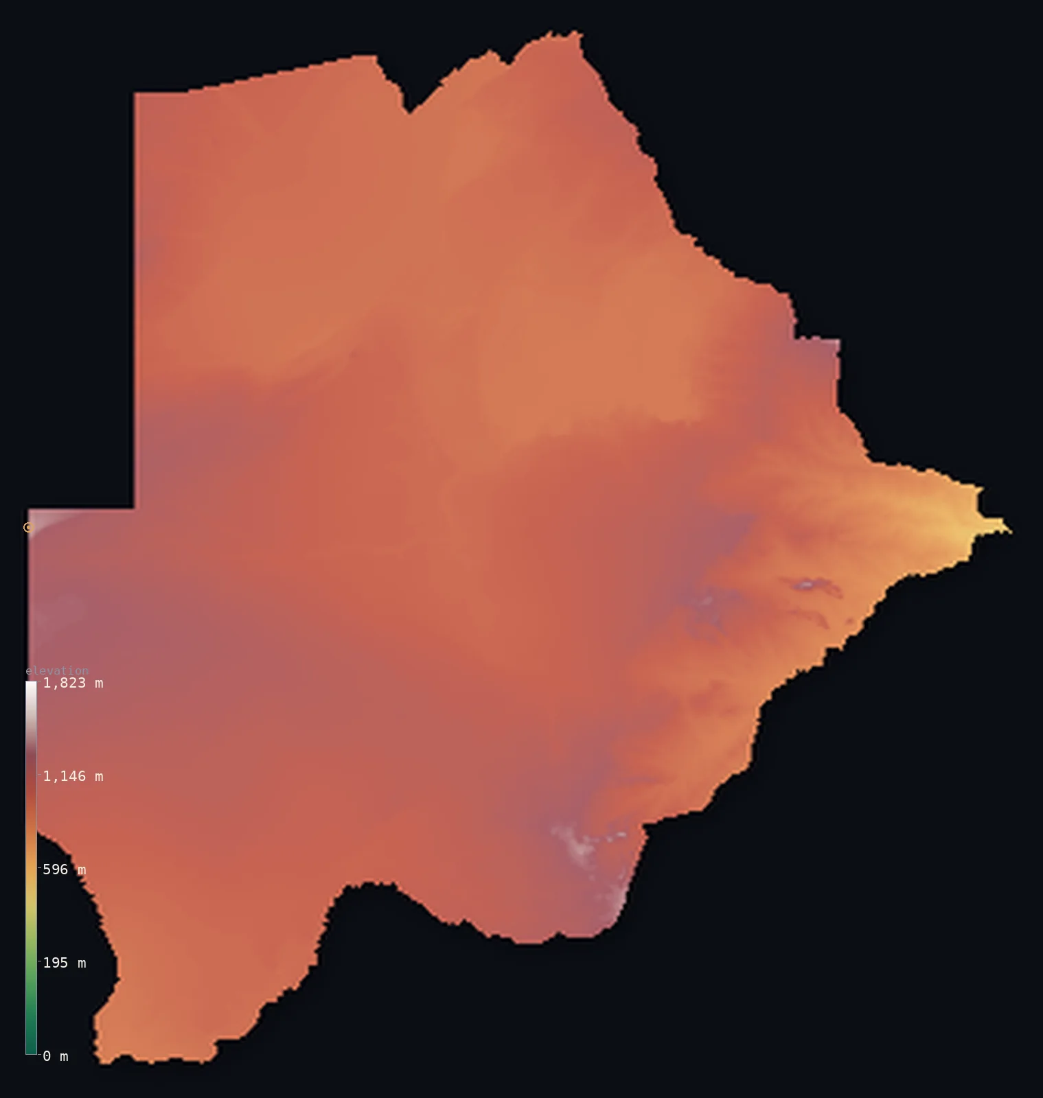
Botswana’s highest point is Monalanong Hill at 4,905 ft (1,495 m); its lowest is Junction of the Limpopo and Shashe Rivers at 1,683 ft (513 m); the mean elevation is 3,383 ft (1,031 m).
Botswana is a large, landlocked country of Southern Africa, and a study in high flatness: a vast tableland sitting around 1,000 m, most of it the semi-arid sands of the Kalahari. It is remarkably even — the Kalahari sandveld of the centre and west and the rockier eastern hardveld both lie near the same height, with no mountains and no true lowlands. Its highest point, Monalanong Hill, reaches only 4,905 ft (1,495 m), and even its lowest, the Limpopo–Shashe junction, is 513 m up — one of the highest national low points on Earth. In the north the plateau dips just enough to gather the Okavango's waters into a great inland delta. About half of Botswana lies below about 3,340 ft, high on the plateau.
- Highest point📚
- 4,905 ft1,495 m
- Botswana's highest point is Monalanong Hill at 4,905 ft (1,495 m), a low hill in the rockier eastern hardveld near Otse, south of the capital Gaborone. Botswana is so flat that the title was long contested — nearby Otse Hill is almost identical — but a 2025 survey confirmed Monalanong as the true summit. It is a hill, not a mountain: the country has no high ground of real relief, only the gentle rise of the hardveld above the Kalahari.
- Lowest point📚
- 1,683 ft513 m
- Botswana's lowest point is the junction of the Limpopo and Shashe rivers in the far east at 1,683 ft (513 m) — and because the whole country sits high on a plateau, even this lowest ground is among the highest national low points in the world. Landlocked and nearly flat, Botswana's lowest point is merely where the eastern rivers leave the tableland.
- Mean elevation⚙
- 3,383 ft1,031 m
- Computed from the GLO-30 model, Botswana's mean elevation is 3,383 ft (1,031 m) — high, but not because the land is mountainous: Botswana is a vast, nearly flat tableland sitting around 1,000 m across the Kalahari and the eastern hardveld. The mean and median are close and both high, for the country is remarkably even — about 57% of it rises above 1,000 m, yet almost none rises much higher.
- Median elevation⚙
- 3,343 ft1,019 m
- Half of Botswana lies below about 3,343 ft (1,019 m) — a high figure, close to the mean, because Botswana is a high, flat plateau: the Kalahari sandveld and the eastern hardveld both sit near 1,000 m, with no mountains and no lowlands to pull the two apart. It is high and even — a tableland, not a range.
- Elevation range📚
- 3,222 ft982 m
- From the Limpopo–Shashe junction at 513 m to Monalanong Hill at 1,495 m, Botswana's terrain spans only about 3,220 ft — a small range for so vast a country, because Botswana is a high, flat tableland: nearly all of it sits around 1,000 m, with only the low hills of the eastern hardveld rising modestly above.
- Above 1,000 m (3,281 ft)⚙
- 57%
- About 57% of Botswana rises above 1,000 m (3,281 ft) — but this is the high plateau itself, not mountains: the Kalahari and the eastern hardveld sit at that height across most of the country. Almost none of Botswana rises much above 1,500 m.
- Official area📚
- 224,607 mi²581,730 km²
- Botswana covers about 224,600 sq mi (581,730 sq km) — a large, landlocked, high-plateau country of Southern Africa, most of it the semi-arid Kalahari sandveld, with the rockier eastern hardveld (holding the highest point) and, in the north, the wetlands of the Okavango Delta and the Makgadikgadi Pans.
- Forest cover📚
- 19.8%
- About 20% of Botswana is wooded — not true forest but the acacia and mopane savanna and thornbush of the Kalahari and the hardveld, with denser woodland and riverine forest only in the wetter north around the Okavango.
Highest and lowest points
A low hill in the southeast, near Otse south of Gaborone — generally taken as the highest point of Botswana at about 1,495 m (the CIA Factbook lists it as 'Manyelanong Hill', a spelling variant). Botswana is so flat that the title is genuinely contested: nearby Otse Hill is almost identical in height, and a 2025 survey-grade GPS measurement put Monalanong at 1,492 m, just 1.9 m above Otse — confirming Monalanong as the true high point.
source ↗Botswana's lowest point is the junction of the Limpopo and Shashe rivers in the far east, at 513 m — and because the whole country is a high plateau, this lowest ground is among the highest national low points in the world. Landlocked and nearly flat, Botswana has three broad natural regions: the vast Kalahari sandveld of deep sands and thornbush savanna filling the centre and west (about 70% of the country); the rockier, slightly higher eastern hardveld, with granite koppies and inselbergs, holding the capital Gaborone and the highest point; and, in the north, the wetlands where the Okavango River, never reaching the sea, spreads into the Okavango Delta beside the salt flats of the Makgadikgadi Pans. From the Tsodilo Hills of the northwest to the Chobe in the far north, Botswana's relief is gentle — a high, dry tableland where most rivers are seasonal and never reach an ocean.
source ↗Botswana at a glance
Botswana is so flat that its highest point is genuinely uncertain — Monalanong Hill (~1,495 m) and nearby Otse Hill are nearly identical, and only a 2025 survey settled that Monalanong is taller, by under two metres.
source ↗Because Botswana sits high on a plateau, even its lowest point — the Limpopo–Shashe river junction — is 513 m above sea level, one of the highest national low points in the world.
source ↗The Kalahari Desert covers about 70% of Botswana — but it is a semi-arid sand savanna of grass and thornbush, not a barren dune desert.
source ↗The Okavango River never reaches the sea: it spreads across the sand into the Okavango Delta, one of the largest inland deltas on Earth, where almost all its water evaporates.
source ↗The Makgadikgadi Pans are the bed of a vast ancient lake that has completely evaporated, leaving salt flats among the largest on the planet.
source ↗The Tsodilo Hills rise abruptly ~400 m from the flat Kalahari and hold thousands of ancient rock paintings — a UNESCO World Heritage Site sacred to the San people.
source ↗Despite many named rivers, most of Botswana's watercourses are seasonal and never reach the sea — only the Chobe, Okavango, Boteti and Limpopo flow reliably.
source ↗
Elevation profile of Botswana
The largest share of land, 38%, falls in the 900–1,000 m band, and 100% of the territory lies above 500 m (1,640 ft).
- 500–1,000 m43%
- 1,000–2,000 m57%
Highest peaks of Botswana
| Peak | Elevation | Range | Note |
|---|---|---|---|
| Monalanong Hill↗ | 4,905 ft1,495 m | southeastern hardveld | Generally taken as Botswana's highest point; a 2025 survey confirmed it just edges out nearby Otse Hill. |
| Otse Hill↗ | 4,892 ft1,491 m | southeastern hardveld | Long cited as the country's high point and almost as tall; a 1999 survey marked its summit at 1,491 m. |
| Tsodilo Hills↗ | 4,885 ft1,489 m | Tsodilo Hills (northwest) | Dramatic quartzite cliffs rising abruptly ~400 m from the Kalahari, a UNESCO World Heritage Site sacred to the San for its rock art. |
| Eastern hardveld inselbergs↗ | 4,593 ft1,400 m | eastern hardveld | Granite inselbergs and koppies dotting the rocky eastern strip around Gaborone and Francistown. |
| Aha Hills↗ | 4,265 ft1,300 m | Aha Hills (far northwest) | Isolated limestone hills on the Namibian border in the remote northwest Kalahari. |
Botswana: the Kalahari, the eastern hardveld, and the northern wetlands
The Kalahari sandveld
The vast central and western sand-filled basin — about 70% of the country — of deep aeolian sands, fossil dunes, and semi-arid acacia and thornbush savanna. The high, dry heart of Botswana.
The eastern hardveld
A rockier, slightly higher and wetter strip down the east, with granite hills, koppies, and inselbergs, more fertile soils, the capital Gaborone, and Botswana's highest point (Monalanong Hill).
The northern wetlands
In the north, the basins of ancient lakes — the Okavango Delta, one of the world's largest inland deltas, where the river spreads across the sand and never reaches the sea, and the Makgadikgadi Pans, vast salt flats left by an evaporated lake.
How to read this map
Color shows elevation; the raised relief shows real terrain. On this map Botswana reads as almost uniform — a vast, even expanse sitting high around 1,000 m, the Kalahari and the eastern hardveld barely distinguishable in height, with only the faint rise of the hardveld hills in the east and the shallow northern basins of the Okavango and Makgadikgadi breaking the flatness.
Because the country is so flat — high, but flat — the 3D exaggeration is what makes any relief visible at all; the ×N relief slider controls how much. Tap anywhere to read that point's exact elevation.
City elevations in Botswana
Botswana's towns lie mostly along the wetter eastern hardveld — Gaborone, the capital, in the southeast, with Francistown to the northeast and Serowe and the mining towns of Selebi-Phikwe and Jwaneng — while Maun in the north is the gateway to the Okavango Delta and Ghanzi stands alone in the western Kalahari.
| City | Population | Elevation |
|---|---|---|
| Gaboronecapitalthe capital, in the southeastern hardveld ↗ | 246,325 | 3,307 ft1,008 m |
| Francistownin the northeastern hardveld ↗ | 103,417 | 3,245 ft989 m |
| Maunin the north, the gateway to the Okavango Delta ↗ | 85,350 | 3,100 ft945 m |
| Serowein the east-central hardveld ↗ | 55,676 | 3,763 ft1,147 m |
| Selebi-Phikwein the east, a copper-nickel mining town ↗ | 42,488 | 2,844 ft867 m |
| Letlhakanein the north-central plateau, near the Makgadikgadi Pans ↗ | 36,404 | 3,215 ft980 m |
| Ghanziin the western Kalahari ↗ | 19,012 | 3,747 ft1,142 m |
| Jwanengin the south, a diamond-mining town ↗ | 18,784 | 3,914 ft1,193 m |
| Tutume | 18,582 | 3,563 ft1,086 m |
| Janeng | 16,853 | 4,285 ft1,306 m |
Elevation sampled at each city centre from the Copernicus GLO-30 model. Cities and population from GeoNames (CC-BY 4.0).
Botswana in comparison
Botswana's terrain rises 3,222 ft (982 m) from Junction of the Limpopo and Shashe Rivers (1,683 ft (513 m)) to Monalanong Hill — about 11% of the height of Mount Everest, the world's highest point at 29,032 ft (8,849 m).
- Namibia's mean elevation is 3,573 ft — 190 ft higher; its high point, Konigstein (Brandberg), reaches 8,442 ft (2,573 m), 3,537 ft above. Namibia elevation map →
- Zimbabwe's mean elevation is 3,192 ft — 190 ft lower; its high point, Mount Nyangani, reaches 8,504 ft (2,592 m), 3,599 ft above. Zimbabwe elevation map →
- Zambia's mean elevation is 3,671 ft — 289 ft higher; its high point, Mafinga Central, reaches 7,674 ft (2,339 m), 2,769 ft above. Zambia elevation map →
Frequently asked questions
What is the highest point in Botswana?
- Monalanong Hill, 4,905 ft (1,495 m), a low hill in the eastern hardveld near Otse, south of Gaborone - confirmed the country's high point by a 2025 survey.
Is Botswana's highest point really uncertain?
- It was: Botswana is so flat that Monalanong Hill and nearby Otse Hill are nearly identical in height. A 2025 survey-grade measurement settled it, putting Monalanong just above Otse.
What is the average elevation of Botswana?
- Computed from the Copernicus GLO-30 model, the area-weighted mean is 3,383 ft (1,031 m) - high, because Botswana is a plateau sitting around 1,000 m, not because it is mountainous. The mean and median (about 3,343 ft (1,019 m)) sit close together.
Is Botswana flat?
- Yes - it is a vast, high, nearly flat tableland around 1,000 m, mostly Kalahari sandveld, with only the low hills of the eastern hardveld rising modestly above. It has no mountains.
Why is Botswana's lowest point so high?
- Because the whole country sits high on a plateau: even the lowest point, the Limpopo-Shashe junction, is 513 m above sea level - one of the highest national low points in the world.
What is the Okavango Delta?
- One of the world's largest inland deltas, in Botswana's north - where the Okavango River spreads across the Kalahari sand and evaporates, never reaching the sea.
Is this a topographic, relief, contour, or elevation map of Botswana?
- They describe the same thing - terrain height. This page renders Botswana's actual elevation surface in interactive 3D and reports the statistics computed from it.
About this map
The terrain is rendered from the Copernicus GLO-30 digital elevation model (ESA), masked to the BWA-ADM0 boundary from geoBoundaries (gbOpen). Elevation statistics are computed directly from the model; peak names and researched facts are sourced and cited. See the methodology for the full pipeline.
Our area-weighted mean, computed from the Copernicus GLO-30 model, is 3,383 ft (1,031 m); the figure commonly cited elsewhere is 3,323 ft (1,013 m) (CIA World Factbook). Botswana is a high, flat, dry country — a vast tableland sitting around 1,000 m, most of it the semi-arid Kalahari sandveld. The land is remarkably even: the Kalahari in the centre and west and the rockier eastern hardveld both lie near the same height, with no mountains and no true lowlands. Even Botswana's lowest point, the Limpopo–Shashe junction, is 513 m up — one of the highest national low points anywhere — and its highest, Monalanong Hill, is only a low rise above the plateau. So the mean and median are close and both high; half the country lies below about 3,343 ft (1,019 m), on the high, level tableland. In the north the plateau dips just enough to gather the Okavango's waters into one of the world's largest inland deltas.
Surveyed national figures: official area · forest cover · high point.
Rendered from Copernicus GLO-30 (ESA, 2021 release), boundaries from geoBoundaries. Generated 2026-06-22.
Bordering countries · 4
Botswana shares a land border with these countries — open any one to compare its terrain and highest point.