South Africa Elevation Map — Topographic & 3D Terrain
Explore the terrain of South Africa in interactive 3D, built from Copernicus GLO-30 satellite elevation data — a high interior plateau that ends at a great escarpment. Drag to rotate, scroll to zoom, and tap any point to read its elevation.
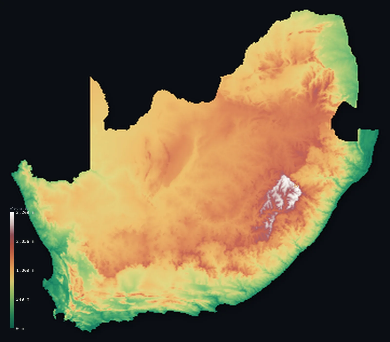
South Africa’s highest point is Mafadi at 11,319 ft (3,450 m); its lowest is Atlantic and Indian Oceans at 0 ft (0 m); the mean elevation is 3,383 ft (1,031 m).
South Africa is a raised interior with a rim. Most of the country is the Highveld plateau, sitting above 1,000 m — so high that its median elevation, 3,507 ft (1,069 m), is actually greater than its mean. The plateau ends abruptly at the Great Escarpment, which drops toward the coasts, and rises highest in the Drakensberg, where Mafadi reaches 11,319 ft (3,450 m) on the Lesotho border.
- Highest point📚
- 11,319 ft3,450 m
- South Africa's highest point is Mafadi at 11,319 ft (3,450 m), on the rim of the Drakensberg where the escarpment meets the Lesotho border — a high point on a plateau edge rather than a freestanding peak.
- Lowest point📚
- 0 ft0 m
- South Africa's lowest point is sea level, along a coastline running from the cold Atlantic around the Cape to the warm Indian Ocean — reached only after the interior plateau has dropped over the Great Escarpment.
- Mean elevation⚙
- 3,383 ft1,031 m
- South Africa's mean elevation computed from the GLO-30 model is 3,383 ft (1,031 m) — high for a country with two coastlines, because the interior plateau occupies the great bulk of the land and sits a kilometre up.
- Median elevation⚙
- 3,507 ft1,069 m
- Half of South Africa lies above 3,507 ft (1,069 m) — higher than the mean, which is unusual and telling: the country is not a mix of high and low but a raised plateau with a narrow low fringe, so the typical point sits higher than the average.
- Elevation range📚
- 11,319 ft3,450 m
- From sea level to Mafadi on the Drakensberg rim, South Africa spans about 11,300 ft — but most of that height is gained in one step, where the Great Escarpment lifts the coastal margin onto the plateau.
- Above 1,000 m (3,281 ft)⚙
- 57%
- About 57% of South Africa lies above 1,000 m (3,281 ft) — the whole Highveld and the interior plateau, which is to say most of the country outside the coastal belt.
- Official area📚
- 471,445 mi²1,221,037 km²
- South Africa covers about 471,445 sq mi (1,221,037 sq km) — and encloses Lesotho entirely, a mountain kingdom set inside its eastern highlands like a hole in the map.
- Forest cover📚
- 14.1%
- Only about 14% of South Africa is forested — the interior is grassland, savanna, and semi-desert Karoo, with woodland limited to the wetter eastern seaboard and the Cape's distinctive fynbos shrubland.
Highest and lowest points
South Africa's highest point is Mafadi, 11,319 ft (3,450 m), on the Drakensberg escarpment at the border with Lesotho. It is a summit on a plateau rim rather than an isolated peak — the edge where the high interior breaks and falls toward KwaZulu-Natal. Lesotho, the enclave entirely surrounded by South Africa, rises higher still at Thabana Ntlenyana (3,482 m), but that lies outside South African territory and outside this map's boundary.
source ↗South Africa's lowest point is sea level, on coasts that face two oceans — the cold Atlantic up the west side, the warm Indian Ocean along the east, meeting near the Cape. What is striking is how little low ground there is: the Great Escarpment runs close to the shore for much of the country, so the coastal plain is narrow and the land climbs to the plateau within a short distance of the sea.
source ↗Mafadi is a border summit: its peak lies just outside the generalized South Africa boundary, so the highest fully in-territory land pixel in the model is 11,312 ft (3,448 m). The headline figure above is the surveyed elevation of the recognised national high point.
South Africa at a glance
South Africa's median elevation is higher than its mean - the country is a raised plateau with a narrow low fringe rather than a mix of highs and lows.
source ↗Most of the country is the Highveld, an interior plateau sitting above 1,000 m, which ends abruptly at the Great Escarpment.
source ↗South Africa completely surrounds Lesotho, a mountain kingdom whose own high point, Thabana Ntlenyana at 3,482 m, is higher than anything in South Africa.
source ↗The Drakensberg range forms the highest section of the Great Escarpment, with basalt cliffs falling more than a kilometre toward the coast.
source ↗South Africa has coastlines on two oceans - the cold Atlantic in the west and the warm Indian Ocean in the east - meeting near the Cape.
source ↗Table Mountain above Cape Town is a flat-topped sandstone massif, the visible southern end of the country's ancient Cape Fold ranges.
source ↗
Elevation profile of South Africa
The largest share of land, 22%, falls in the 1,000–1,250 m band, and 85% of the territory lies above 500 m (1,640 ft).
- below 500 m (1,640 ft)15%
- 500–1,000 m28%
- 1,000–2,000 m56%
- above 2,000 m (6,562 ft)1%
Highest peaks of South Africa
| Peak | Elevation | Range | Note |
|---|---|---|---|
| Mafadi↗ | 11,319 ft3,450 m | Drakensberg | Highest point of South Africa, on the Lesotho border in the central Drakensberg. |
| Njesuthi↗ | 11,181 ft3,408 m | Drakensberg | One of the highest Drakensberg summits, near Mafadi on the Lesotho border. |
| Champagne Castle↗ | 11,079 ft3,377 m | Drakensberg | Often cited as South Africa's highest free-standing summit by prominence. |
| Giant's Castle↗ | 10,876 ft3,315 m | Drakensberg | A prominent peak of the central Drakensberg, popular with hikers. |
| Table Mountain↗ | 3,563 ft1,086 m | Cape Fold Mountains | The flat-topped landmark above Cape Town - far lower, but among the country's most famous heights. |
Plateau, escarpment, coast
The interior plateau (the Highveld and Karoo)
Most of South Africa is a high inland plateau above 1,000 m — the grassy Highveld in the northeast where Johannesburg and Pretoria stand, and the dry, sparse Karoo to the southwest. Level and elevated, it makes the country high on average without containing many mountains.
The Great Escarpment and the Drakensberg
The plateau ends at the Great Escarpment, a near-continuous step that runs in an arc around the interior and drops sharply toward the coasts. Its highest and most dramatic section is the Drakensberg in the east, where basalt walls rise past 3,000 m along the Lesotho border and carry Mafadi, the country's high point.
The coastal belt and the Cape
Below the escarpment lies a narrow coastal margin — subtropical along the Indian Ocean, drier on the Atlantic side — widening in the southwest around the Cape, where the folded Cape ranges and Table Mountain give the region its distinctive stepped and flat-topped skyline.
How to read this map
Color shows elevation; the raised relief shows real terrain. On this map South Africa reads as a broad raised brown interior with a sharp edge — the Great Escarpment — dropping to a narrow green coastal band, and the white of Lesotho's mountains showing as a hole in the country's eastern highlands.
The 3D relief is the actual GLO-30 elevation data, exaggerated vertically so the plateau step stands out; the ×N relief slider controls how much. Tap anywhere to read that point's exact elevation.
City elevations in South Africa
South African cities sit high because the country does. Johannesburg and Pretoria stand above 4,300 ft on the Highveld plateau, while Cape Town and Durban lie at sea level below the escarpment — a division that shapes the climate of each.
| City | Population | Elevation |
|---|---|---|
| Johannesburg | 9,418,183 | 5,728 ft1,746 m |
| Cape Townat sea level beneath Table Mountain, where the Cape ranges meet the Atlantic ↗ | 4,772,846 | 62 ft19 m |
| Durbanon the warm Indian Ocean coast at sea level, below the escarpment ↗ | 3,338,026 | 33 ft10 m |
| Pretoriacapitalthe administrative capital, on the Highveld plateau at about 1,320 m ↗ | 2,112,693 | 4,341 ft1,323 m |
| Gqeberha | 1,050,078 | 210 ft64 m |
| Bloemfontein | 556,637 | 4,564 ft1,391 m |
| East London | 478,676 | 144 ft44 m |
| Welkom | 431,944 | 4,488 ft1,368 m |
| Newcastle | 404,838 | 3,911 ft1,192 m |
| Maseru | 359,753 | 5,062 ft1,543 m |
Elevation sampled at each city centre from the Copernicus GLO-30 model. Cities and population from GeoNames (CC-BY 4.0).
South Africa in comparison
South Africa's terrain rises 11,319 ft (3,450 m) from sea level to Mafadi — about 39% of the height of Mount Everest, the world's highest point at 29,032 ft (8,849 m).
- Lesotho's mean elevation is 7,260 ft — 3,878 ft higher; its high point, Thabana Ntlenyana, reaches 11,424 ft (3,482 m), 105 ft above. Lesotho elevation map →
- Eswatini's mean elevation is 2,064 ft — 1,319 ft lower; its high point, Emlembe, reaches 6,109 ft (1,862 m), 5,210 ft below. Eswatini elevation map →
- Namibia's mean elevation is 3,573 ft — 190 ft higher; its high point, Konigstein (Brandberg), reaches 8,442 ft (2,573 m), 2,877 ft below. Namibia elevation map →
Frequently asked questions
What is the highest point in South Africa?
- Mafadi, 11,319 ft (3,450 m), on the Drakensberg escarpment at the Lesotho border - a high point on the plateau rim rather than a freestanding peak.
What is the lowest point in South Africa?
- Sea level, on coasts facing both the Atlantic and the Indian Ocean.
What is the average elevation of South Africa?
- Computed from the Copernicus GLO-30 model, the area-weighted mean is 3,383 ft (1,031 m) - high, because the interior plateau covers most of the country.
Does South Africa have three capitals?
- Yes - Pretoria is the administrative capital, Cape Town the legislative, and Bloemfontein the judicial, a division dating from the country's formation in 1910.
What is the Great Escarpment?
- The near-continuous step where South Africa's high interior plateau ends and drops toward the coasts - highest in the Drakensberg, where it exceeds 3,000 m.
Is this a topographic, relief, contour, or elevation map of South Africa?
- They describe the same thing - terrain height. This page renders the country's actual elevation surface in interactive 3D and reports the statistics computed from it.
About this map
The terrain is rendered from the Copernicus GLO-30 digital elevation model (ESA), masked to the ZAF-ADM0 boundary from geoBoundaries (gbOpen). Elevation statistics are computed directly from the model; peak names and researched facts are sourced and cited. See the methodology for the full pipeline.
Our area-weighted mean, computed from the Copernicus GLO-30 model, is 3,383 ft (1,031 m); the figure commonly cited elsewhere is 3,392 ft (1,034 m) (CIA World Factbook). South Africa is built around a high interior plateau, most of it above 1,000 m and tilted so it stands highest in the east, ringed by the Great Escarpment and dropping to narrow coastal plains - so its mean elevation is high; the page reports the area-weighted figure computed from the Copernicus GLO-30 model.
Surveyed national figures: official area · forest cover · high point.
Rendered from Copernicus GLO-30 (ESA, 2021 release), boundaries from geoBoundaries. Generated 2026-07-07.
Bordering countries · 6
South Africa shares a land border with these countries — open any one to compare its terrain and highest point.