Lesotho Elevation Map — Topographic & 3D Terrain
Explore the terrain of Lesotho in interactive 3D, built from Copernicus GLO-30 satellite elevation data — the 'Kingdom in the Sky,' a high basalt plateau of the Maloti and Drakensberg mountains entirely above 1,400 m. Drag to rotate, scroll to zoom, and tap any point to read its elevation.
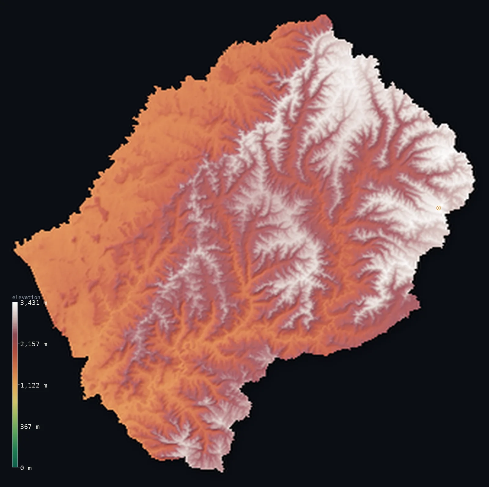
Lesotho’s highest point is Thabana Ntlenyana at 11,424 ft (3,482 m); its lowest is Makhaleng-Orange (Senqu) river junction at 4,593 ft (1,400 m); the mean elevation is 7,260 ft (2,213 m).
Lesotho is the highest country on Earth — a small, landlocked kingdom set entirely on high ground, an enclave within South Africa often called the Kingdom in the Sky. Every part of it is elevated: the eastern and central Maloti and Drakensberg mountains, a high basalt plateau covering about two-thirds of the country, rise to Thabana Ntlenyana at 11,424 ft (3,482 m) — the highest peak in Southern Africa — while even the western 'lowlands' sit at 1,400–1,800 m. Lesotho has no lowland at all: its lowest point, about 4,593 ft (1,400 m), is the highest low point of any nation. Half the country lies above about 7,240 ft, and all of it above 1,000 m.
- Highest point📚
- 11,424 ft3,482 m
- Lesotho's highest point is Thabana Ntlenyana at 11,424 ft (3,482 m), on the Mohlesi ridge in the Maloti Mountains of the east, just west of the KwaZulu-Natal border — the highest peak in Southern Africa. Its name means 'beautiful little mountain,' yet it crowns the high basalt plateau that fills the country; it rises only some 2,000 ft above the surrounding highlands, for in Lesotho even the valleys are high.
- Lowest point📚
- 4,593 ft1,400 m
- Lesotho's lowest point is about 4,593 ft (1,400 m), where the Makhaleng meets the Orange (Senqu) River in the west — and it is the highest low point of any country on Earth. No land in Lesotho lies below about 1,400 m: the whole nation sits on high ground, which is why it is called the Kingdom in the Sky.
- Mean elevation⚙
- 7,260 ft2,213 m
- Computed from the GLO-30 model, Lesotho's mean elevation is 7,260 ft (2,213 m) — among the highest of any country, because Lesotho is high throughout. There are no lowlands here: the whole country is a high basalt plateau, so the mean and median are close and both very high, and half of Lesotho lies above about 7,241 ft (2,207 m). Even its lowest ground stands above 1,400 m.
- Median elevation⚙
- 7,241 ft2,207 m
- Half of Lesotho lies above about 7,241 ft (2,207 m) — an extraordinarily high midpoint, because the entire country is high: the eastern and central Maloti and Drakensberg highlands, a basalt plateau covering about two-thirds of Lesotho, and even the western lowlands sit at 1,400–1,800 m. There is no low ground to speak of; Lesotho is high from edge to edge.
- Elevation range📚
- 6,831 ft2,082 m
- From its lowest point at 1,400 m to Thabana Ntlenyana at 3,482 m, Lesotho's terrain spans about 6,830 ft — but the whole of that range sits high: the country has no land below about 1,400 m, so its relief is that of a high plateau and the mountains rising from it, not of a climb up from any lowland.
- Above 1,000 m (3,281 ft)⚙
- 100%
- All of Lesotho rises above 1,000 m (3,281 ft) — it is the only independent country in the world that lies entirely above that height, and nearly all of it stands above 1,500 m, on a basalt plateau where snow can fall even in summer.
- Above 2,000 m (6,562 ft)⚙
- 61%
- About 61% of Lesotho rises above 2,000 m (6,562 ft) — most of the country is not merely high but mountainous, a basalt plateau deeply cut by rivers, rising to the peaks of the Maloti and the Drakensberg.
- Official area📚
- 11,720 mi²30,355 km²
- Lesotho covers about 11,720 sq mi (30,355 sq km) — a small, landlocked kingdom of Southern Africa, an enclave entirely surrounded by South Africa, and the highest country on Earth: a basalt plateau of the Maloti and Drakensberg mountains, foothills, and western lowlands, all of it above 1,400 m.
- Forest cover📚
- 1.6%
- About 2% of Lesotho is forested — a high, treeless country of alpine and montane grassland, its basalt slopes and valleys under tussock and pasture rather than woodland, with only small plantations near the towns.
Highest and lowest points
The highest point of Lesotho at 3,482 m - Thabana Ntlenyana ('beautiful little mountain'), the highest peak in all of Africa south of Kilimanjaro. It rises on the Mohlesi ridge in the Maloti Mountains of the east, just west of the KwaZulu-Natal border, so it is an interior summit. The whole massif is amygdaloidal flood basalt.
source ↗Lesotho's lowest point, at about 1,400 m, lies where the Makhaleng joins the Orange (Senqu) River in the west — and it is the highest low point of any country in the world. Lesotho is a landlocked enclave entirely surrounded by South Africa, and every part of it is high: the east and centre are the Maloti and Drakensberg mountains, a basalt plateau (about two-thirds of the country) rising to Thabana Ntlenyana (3,482 m), the highest peak in Southern Africa, where snow can fall even in summer; a belt of foothills descends westward; and the western 'lowlands' along the Caledon and Senqu, the main farming and population strip, still stand at 1,400–1,800 m. The Orange (Senqu), South Africa's longest river, rises here in the Drakensberg, and Lesotho's chief resource is the water it sends down to South Africa. It is the Kingdom in the Sky — a whole country on high ground, with no lowland at all.
source ↗Lesotho at a glance
Lesotho is the only independent country in the world that lies entirely above 1,000 m - and its lowest point, 1,400 m, is the highest low point of any country, earning it the name 'the Kingdom in the Sky'.
source ↗About three-quarters of Lesotho lies above 1,800 m, on a high basalt plateau where snow can fall even in summer.
source ↗Thabana Ntlenyana (3,482 m) is the highest mountain in all of Africa south of Kilimanjaro.
source ↗Lesotho is one of only a few countries completely surrounded by a single other country - it is an enclave entirely within South Africa.
source ↗The Orange (Senqu) River, South Africa's longest, rises in Lesotho's Drakensberg and the country exports water to South Africa through the Lesotho Highlands Water Project.
source ↗The Letseng diamond mine in the Maloti mountains is one of the highest-elevation diamond mines in the world, famous for very large, high-value stones.
source ↗
Elevation profile of Lesotho
The largest share of land, 17%, falls in the 1,600–1,800 m band, and 100% of the territory lies above 500 m (1,640 ft).
- 1,000–2,000 m39%
- above 2,000 m (6,562 ft)61%
Highest peaks of Lesotho
| Peak | Elevation | Range | Note |
|---|---|---|---|
| Thabana Ntlenyana↗ | 11,424 ft3,482 m | Maloti / Drakensberg (east) | Highest point of Lesotho and of all Africa south of Kilimanjaro, on the Mohlesi ridge north of Sani Pass. |
| Mafadi↗ | 11,319 ft3,450 m | Drakensberg escarpment (South Africa border, east) | On the Drakensberg escarpment forming the eastern border - it is also the highest point of South Africa. |
| Makheka↗ | 11,207 ft3,416 m | Maloti highlands (northeast) | A high basalt summit of the interior Maloti highlands of northeastern Lesotho. |
Lesotho: the highland plateau, the foothills, and the western lowlands
The highlands
The eastern and central Maloti and Drakensberg mountains — a high basalt plateau covering about two-thirds of Lesotho, rising to Thabana Ntlenyana and cut by deep river valleys. Snow can fall here even in summer; the Orange (Senqu), South Africa's longest river, rises here.
The foothills
A belt of broken, undulating country between the western lowlands and the eastern highlands, descending westward from the mountains.
The western lowlands
A strip along the Caledon and the Senqu valley — lower, though still around 1,400–1,800 m, and the country's main farming and population belt, holding the capital Maseru.
How to read this map
Color shows elevation; the raised relief shows real terrain. On this map Lesotho reads as high everywhere — there is no low green at all; the whole country glows in the high browns and whites of elevation, deepening eastward into the Maloti and Drakensberg (highest at Thabana Ntlenyana) and easing only slightly to the still-high western 'lowlands.'
Uniquely, nothing here lies below about 1,400 m, so the relief you see is mountains rising from a high plateau, not from any lowland; the ×N relief slider controls the exaggeration. Tap anywhere to read that point's exact elevation.
City elevations in Lesotho
Almost all of Lesotho's towns lie in the lower western strip along the Caledon River — Maseru, the capital, with Maputsoe, Teyateyaneng, Mafeteng, and Mohale's Hoek — for the high eastern highlands are thinly peopled; only a few centres like Mokhotlong and Thaba-Tseka sit up in the mountains, though even the western 'lowlands' stand above 1,400 m.
| City | Population | Elevation |
|---|---|---|
| Maserucapitalthe capital, in the western lowlands on the Caledon River ↗ | 359,753 | 5,062 ft1,543 m |
| Maputsoein the northwestern lowlands ↗ | 61,916 | 5,187 ft1,581 m |
| Mohale's Hoekin the southwestern lowlands ↗ | 46,593 | 5,226 ft1,593 m |
| Mafetengin the western lowlands ↗ | 45,287 | 5,469 ft1,667 m |
| Butha-Buthein the northern lowlands, below the highlands ↗ | 40,599 | 5,604 ft1,708 m |
| Quthing | 33,910 | 4,964 ft1,513 m |
| Teyateyanengin the northwestern lowlands ↗ | 27,272 | 5,541 ft1,689 m |
| Qacha’s Nek | 25,573 | 6,440 ft1,963 m |
| Thaba-Tsekain the central highlands ↗ | 16,765 | 7,300 ft2,225 m |
| Mokhotlongin the eastern highlands, near Thabana Ntlenyana ↗ | 14,461 | 7,218 ft2,200 m |
Elevation sampled at each city centre from the Copernicus GLO-30 model. Cities and population from GeoNames (CC-BY 4.0).
Lesotho in comparison
Lesotho's terrain rises 6,831 ft (2,082 m) from Makhaleng-Orange (Senqu) river junction (4,593 ft (1,400 m)) to Thabana Ntlenyana — about 24% of the height of Mount Everest, the world's highest point at 29,032 ft (8,849 m).
- South Africa's mean elevation is 3,383 ft — 3,878 ft lower; its high point, Mafadi, reaches 11,319 ft (3,450 m), 105 ft below. South Africa elevation map →
- Eswatini's mean elevation is 2,064 ft — 5,197 ft lower; its high point, Emlembe, reaches 6,109 ft (1,862 m), 5,315 ft below. Eswatini elevation map →
- Rwanda's mean elevation is 5,610 ft — 1,650 ft lower; its high point, Mount Karisimbi, reaches 14,787 ft (4,507 m), 3,363 ft above. Rwanda elevation map →
Frequently asked questions
What is the highest point in Lesotho?
- Thabana Ntlenyana, 11,424 ft (3,482 m), in the Maloti Mountains of the east - the highest peak in Southern Africa. Its name means 'beautiful little mountain.'
What is the lowest point in Lesotho?
- About 4,593 ft (1,400 m), where the Makhaleng meets the Orange (Senqu) River - the highest low point of any country on Earth. No land in Lesotho lies below about 1,400 m.
What is the average elevation of Lesotho?
- Computed from the Copernicus GLO-30 model, the area-weighted mean is 7,260 ft (2,213 m) - among the highest of any country, because Lesotho is high throughout. Half of it lies above about 7,241 ft (2,207 m).
Why is Lesotho called the Kingdom in the Sky?
- Because it is the only country in the world lying entirely above 1,000 m - its lowest point, about 1,400 m, is the highest low point of any nation, and over 60% of it above 2,000 m.
Where are the mountains in Lesotho?
- Everywhere - the whole country is high. The Maloti and Drakensberg highlands fill the east and centre (about two-thirds of Lesotho), rising to Thabana Ntlenyana; even the western 'lowlands' sit at 1,400-1,800 m.
Is this a topographic, relief, contour, or elevation map of Lesotho?
- They describe the same thing - terrain height. This page renders Lesotho's actual elevation surface in interactive 3D and reports the statistics computed from it.
About this map
The terrain is rendered from the Copernicus GLO-30 digital elevation model (ESA), masked to the LSO-ADM0 boundary from geoBoundaries (gbOpen). Elevation statistics are computed directly from the model; peak names and researched facts are sourced and cited. See the methodology for the full pipeline.
Our area-weighted mean, computed from the Copernicus GLO-30 model, is 7,260 ft (2,213 m); the figure commonly cited elsewhere is 7,090 ft (2,161 m) (CIA World Factbook). Lesotho is the highest country on Earth — the only independent nation lying entirely above 1,000 m, and its lowest point, at about 1,400 m, is the highest low point of any country. The whole of it is high ground: the eastern and central Maloti and Drakensberg mountains, a basalt plateau covering some two-thirds of the country and rising to Thabana Ntlenyana, the highest peak in Southern Africa; a belt of broken foothills; and the 'lowlands' of the west, which still sit at 1,400–1,800 m. There is no low ground to reframe around — the mean and median are close and both very high, and half of Lesotho lies above about 7,241 ft (2,207 m). It is the Kingdom in the Sky, a nation set entirely on the roof of the region, whose rivers flow down and out to South Africa on every side.
Surveyed national figures: official area · forest cover · high point.
Rendered from Copernicus GLO-30 (ESA, 2021 release), boundaries from geoBoundaries. Generated 2026-06-23.
Bordering countries · 1
Lesotho shares a land border with these countries — open any one to compare its terrain and highest point.