Eswatini Elevation Map — Topographic & 3D Terrain
Explore the terrain of Eswatini in interactive 3D, built from Copernicus GLO-30 satellite elevation data — a small kingdom of four 'veld' steps descending from the Highveld to the Lowveld. Drag to rotate, scroll to zoom, and tap any point to read its elevation.
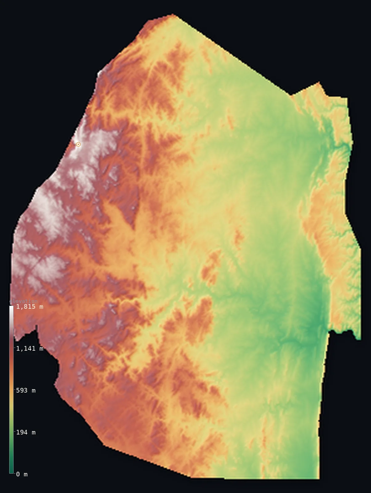
Eswatini’s highest point is Emlembe at 6,109 ft (1,862 m); its lowest is Great Usutu River at 69 ft (21 m); the mean elevation is 2,064 ft (629 m).
Eswatini is a small, landlocked kingdom between South Africa and Mozambique, laid out as a staircase that steps down from west to east in four parallel 'veld' bands. In the west rises the mountainous Highveld, on the edge of the Drakensberg escarpment, holding the high point, Emlembe, at 6,109 ft (1,862 m), and the capital Mbabane. From there the land drops: the transitional Middleveld of hills and valleys around 700 m, the hot Lowveld plain around 250 m, and the narrow Lubombo ridge along the Mozambique border. Because the height is gathered in the west, half of Eswatini lies below about 1,670 ft, in the lower steps, while the Highveld lifts the average above.
- Highest point📚
- 6,109 ft1,862 m
- Eswatini's highest point is Emlembe at 6,109 ft (1,862 m), in the mountainous Highveld of the northwest, on the South Africa border at the edge of the Drakensberg escarpment near the former mining town of Bulembu. Its summit ridge is shared with South Africa's Mpumalanga province. Emlembe crowns the western Highveld — the highest of the four 'veld' steps down which the country descends toward the east.
- Lowest point📚
- 69 ft21 m
- Eswatini's lowest point is the Great Usutu (Lusutfu) River at about 69 ft (21 m), where it leaves the country through the low eastern Lowveld toward Mozambique. From this hot, low bushveld the land steps up westward through the Middleveld to the mountainous Highveld — Eswatini's terrain is a staircase, climbing from the east to the Drakensberg edge in the west.
- Mean elevation⚙
- 2,064 ft629 m
- Computed from the GLO-30 model, Eswatini's mean elevation is 2,064 ft (629 m) — lifted by the mountainous western Highveld, though half the country lies below about 1,673 ft (510 m), in the lower Middleveld and Lowveld. Eswatini steps down from west to east, so its high ground is gathered on the Highveld while much of the land — the central hills and the hot eastern plain — lies well below the average.
- Median elevation⚙
- 1,673 ft510 m
- Half of Eswatini lies below about 1,673 ft (510 m) — below the mean, because the country's height is concentrated in the west: the mountainous Highveld holds the high ground, while the transitional Middleveld (around 700 m) and the hot Lowveld (around 250 m) make up much of the land, dropping away eastward. Only the Lubombo ridge on the Mozambique border interrupts the eastern plain.
- Elevation range📚
- 6,040 ft1,841 m
- From the Great Usutu River at 21 m to Emlembe at 1,862 m, Eswatini's terrain climbs about 6,040 ft — a wide range for a small country, gained in a staircase of four 'veld' steps from the hot eastern Lowveld up through the Middleveld to the mountainous western Highveld on the Drakensberg edge.
- Above 1,000 m (3,281 ft)⚙
- 21%
- About 21% of Eswatini rises above 1,000 m (3,281 ft) — the mountainous Highveld of the west, on the Drakensberg edge, holding Emlembe. The Middleveld, the Lowveld, and the Lubombo ridge to the east all lie below.
- Official area📚
- 6,704 mi²17,363 km²
- Eswatini covers about 6,704 sq mi (17,363 sq km) — a small, landlocked kingdom between South Africa and Mozambique, laid out in four parallel 'veld' steps from west to east: the mountainous Highveld (holding Emlembe), the transitional Middleveld, the hot Lowveld plain, and the Lubombo escarpment along the Mozambique border.
- Forest cover📚
- 34.2%
- About 34% of Eswatini is forested — natural montane forest and grassland on the wet Highveld, plus extensive commercial timber plantations, giving way eastward to the wooded savanna and thornveld of the drier Middleveld and Lowveld.
Highest and lowest points
The highest point of Eswatini at 1,862 m - Emlembe, in the mountainous Highveld of the northwest, on the South Africa border at the edge of the Drakensberg (Great Escarpment), near the former mining town of Bulembu. Its summit ridge is shared with South Africa's Mpumalanga province.
source ↗Eswatini's lowest point is the Great Usutu (Lusutfu) River at about 21 m, where it crosses the Lowveld toward Mozambique. A landlocked kingdom between South Africa and Mozambique, its terrain is a clear staircase of four steps from west to east. In the west stands the mountainous Highveld, 1,000–1,900 m on the edge of the Drakensberg escarpment, holding Emlembe (its summit ridge shared with South Africa) and the capital, Mbabane. It steps down through the Middleveld — a plateau of hills and fertile valleys around 700 m, the agricultural and industrial core and the most densely peopled region — to the Lowveld, a hot eastern plain around 250 m of bush and savanna with big game reserves. Along the Mozambique border rises the Lubombo, a narrow escarpment ridge cut by the gorges of rivers draining eastward. All of Eswatini's major rivers rise in or beyond the western mountains and flow east across the steps toward the Indian Ocean.
source ↗Eswatini at a glance
Eswatini's highest point, Emlembe (1,862 m), sits on the South Africa border at the edge of the Drakensberg - its summit ridge is shared with South Africa's Mpumalanga province.
source ↗The country is laid out in four parallel 'veld' steps running north-south - Highveld, Middleveld, Lowveld and the Lubombo ridge - dropping from about 1,800 m in the west to 250 m in the east.
source ↗Eswatini is one of the few landlocked countries in Africa, almost completely surrounded by South Africa, with only a short eastern border on Mozambique.
source ↗Ngwenya mountain on the western border holds Lion Cavern, regarded as one of the oldest known mines in the world, where ochre was dug tens of thousands of years ago.
source ↗Above Mbabane rises Sibebe, an enormous exposed granite dome often called one of the largest monoliths on Earth.
source ↗All of Eswatini's major rivers rise in or beyond the western mountains and flow eastward across the country toward the Indian Ocean, cutting deep gorges through the Lubombo ridge.
source ↗
Elevation profile of Eswatini
The largest share of land, 33%, falls in the 200–400 m band, with the land split almost evenly above and below 500 m (1,640 ft).
- below 500 m (1,640 ft)49%
- 500–1,000 m30%
- 1,000–2,000 m21%
Highest peaks of Eswatini
| Peak | Elevation | Range | Note |
|---|---|---|---|
| Emlembe↗ | 6,109 ft1,862 m | Highveld / Drakensberg (South Africa border) | Highest point of Eswatini, on the South Africa border near Bulembu. |
| Ngwenya↗ | 6,001 ft1,829 m | Highveld (northwest) | A Highveld peak on the western border, site of Lion Cavern - one of the world's oldest known mines. |
| Sibebe↗ | 4,882 ft1,488 m | Highveld (near Mbabane) | A vast exposed granite dome (whaleback) above Mbabane, one of the largest monoliths in the world. |
Eswatini: the Highveld, the Middleveld, the Lowveld, and the Lubombo
The Highveld (west)
The mountainous western strip on the edge of the Drakensberg escarpment, 1,000–1,900 m high, holding Emlembe and the capital Mbabane — the country's high, wet ground.
The Middleveld (centre)
A transitional plateau of hills and fertile valleys around 700 m — the most densely populated region and the agricultural and industrial core, holding Manzini.
The Lowveld (east)
The low eastern plain around 250 m, of hot bush and savanna grassland with thorn trees — lower population and big game reserves.
The Lubombo (far east)
A narrow escarpment ridge rising about 600 m along the Mozambique border, cut by the gorges of the rivers that drain eastward to the Indian Ocean.
How to read this map
Color shows elevation; the raised relief shows real terrain. On this map Eswatini reads as a clear staircase from west to east — the high browns of the Highveld and Emlembe on the western edge, stepping down through the middle-toned Middleveld, to the low green of the eastern Lowveld, with the thin ridge of the Lubombo rising again along the far border.
The four 'veld' steps show plainly in the color banding; the 3D exaggeration sharpens them, and the ×N relief slider controls how much. Tap anywhere to read that point's exact elevation.
City elevations in Eswatini
Eswatini's main towns sit in the western Highveld and central Middleveld — Mbabane, the capital, in the mountainous northwest, and Manzini, the largest, in the Middleveld — with smaller centres like Piggs Peak up in the Highveld and Big Bend and Siteki down in the eastern Lowveld and Lubombo.
| City | Population | Elevation |
|---|---|---|
| Manzinithe largest city, in the central Middleveld ↗ | 110,537 | 1,969 ft600 m |
| Mbabanecapitalthe capital, in the mountainous western Highveld ↗ | 76,218 | 3,947 ft1,203 m |
| Malkernsin the central Middleveld ↗ | 9,724 | 2,533 ft772 m |
| Nhlanganoin the southwestern Highveld ↗ | 9,016 | 3,425 ft1,044 m |
| Mhlumein the northeastern Lowveld ↗ | 8,652 | 951 ft290 m |
| Hluti | 6,763 | 2,133 ft650 m |
| Big Bendin the southeastern Lowveld, on the Great Usutu ↗ | 6,433 | 371 ft113 m |
| Sitekiin the east, on the Lubombo ridge ↗ | 6,152 | 2,156 ft657 m |
| Piggs Peakin the northwestern Highveld, near Emlembe ↗ | 5,750 | 3,301 ft1,006 m |
| Bhunya | 3,046 | 3,009 ft917 m |
Elevation sampled at each city centre from the Copernicus GLO-30 model. Cities and population from GeoNames (CC-BY 4.0).
Eswatini in comparison
Eswatini's terrain rises 6,040 ft (1,841 m) from Great Usutu River (69 ft (21 m)) to Emlembe — about 21% of the height of Mount Everest, the world's highest point at 29,032 ft (8,849 m).
- South Africa's mean elevation is 3,383 ft — 1,319 ft higher; its high point, Mafadi, reaches 11,319 ft (3,450 m), 5,210 ft above. South Africa elevation map →
- Lesotho's mean elevation is 7,260 ft — 5,197 ft higher; its high point, Thabana Ntlenyana, reaches 11,424 ft (3,482 m), 5,315 ft above. Lesotho elevation map →
- Mozambique's mean elevation is 1,161 ft — 902 ft lower; its high point, Monte Binga, reaches 7,992 ft (2,436 m), 1,883 ft above. Mozambique elevation map →
Frequently asked questions
What is the highest point in Eswatini?
- Emlembe, 6,109 ft (1,862 m), in the western Highveld on the South Africa border - its summit ridge shared with South Africa's Mpumalanga province.
What is the lowest point in Eswatini?
- The Great Usutu (Lusutfu) River at about 69 ft (21 m), in the low eastern Lowveld toward Mozambique.
What is the average elevation of Eswatini?
- No standard source publishes one, so this page reports the mean computed from the Copernicus GLO-30 model, 2,064 ft (629 m). It is lifted by the western Highveld; about half the country lies below about 1,673 ft (510 m).
What are the regions of Eswatini?
- Four parallel 'veld' steps from west to east: the mountainous Highveld, the transitional Middleveld, the hot Lowveld plain, and the Lubombo escarpment on the Mozambique border.
Is Eswatini landlocked?
- Yes - a small landlocked kingdom almost entirely surrounded by South Africa, with only a short eastern border on Mozambique.
Is this a topographic, relief, contour, or elevation map of Eswatini?
- They describe the same thing - terrain height. This page renders Eswatini's actual elevation surface in interactive 3D and reports the statistics computed from it.
About this map
The terrain is rendered from the Copernicus GLO-30 digital elevation model (ESA), masked to the SWZ-ADM0 boundary from geoBoundaries (gbOpen). Elevation statistics are computed directly from the model; peak names and researched facts are sourced and cited. See the methodology for the full pipeline.
Our area-weighted mean, computed from the Copernicus GLO-30 model, is 2,064 ft (629 m); no authority publishes a mean elevation (No authoritative published mean elevation). Eswatini is a small kingdom laid out as a staircase, dropping from west to east in four parallel 'veld' steps. In the west rises the mountainous Highveld, on the edge of the Drakensberg escarpment, holding the high point, Emlembe, and the capital Mbabane — the country's high, wet ground. From there the land steps down: the transitional Middleveld of hills and fertile valleys around 700 m, the most densely settled region; the hot, low Lowveld of bush and savanna around 250 m; and, along the Mozambique border, the narrow Lubombo escarpment. Because the height is gathered in the western Highveld, the mean is lifted above the typical point, and half of Eswatini lies below about 1,673 ft (510 m), in the Middleveld and Lowveld. No standard source publishes a mean elevation for Eswatini; the figure here is computed directly from the GLO-30 surface.
Surveyed national figures: official area · forest cover · high point.
Rendered from Copernicus GLO-30 (ESA, 2021 release), boundaries from geoBoundaries. Generated 2026-06-23.
Bordering countries · 2
Eswatini shares a land border with these countries — open any one to compare its terrain and highest point.