Africa Elevation Map
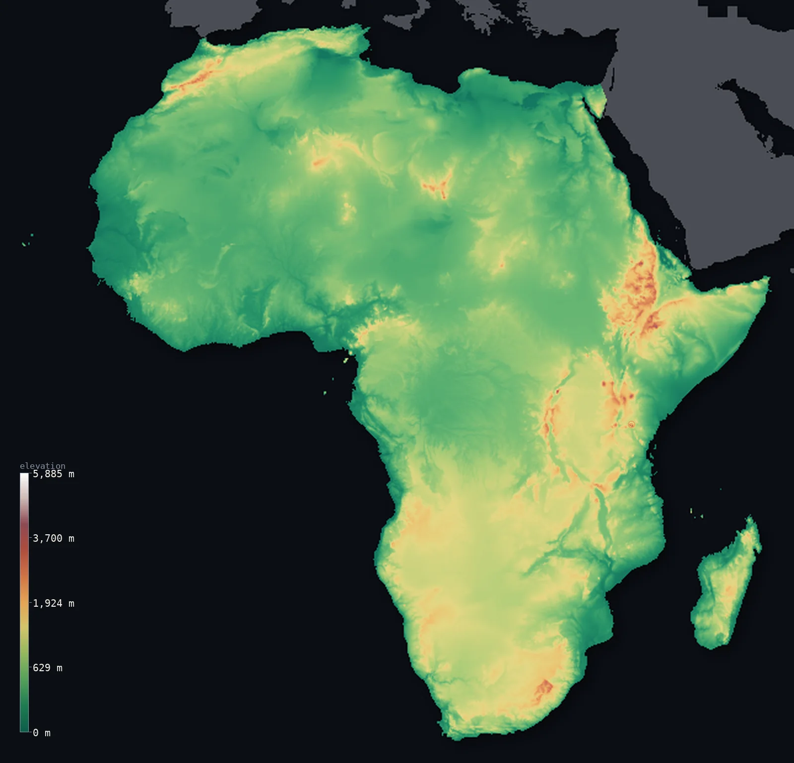
Africa’s highest point is Mount Kilimanjaro at 19,341 ft (5,895 m); its lowest is Lake Assal at −509 ft (−155 m); the mean elevation is 2,054 ft (626 m).
- Highest point📚
- 19,341 ft5,895 m
- Africa's highest point is Mount Kilimanjaro at 19,341 ft (5,895 m), in northern Tanzania - a great dormant volcano rising alone from the plains near the Equator, the tallest free-standing mountain on Earth. Snow-capped despite standing just south of the Equator, it towers far above the East African savanna, the highest of the volcanoes and massifs that rise along the Great Rift Valley - the highest point on the whole continent.
- Lowest point📚
- −509 ft−155 m
- Africa's lowest point is Lake Assal in Djibouti, at about 509 ft (155 m) below sea level - a hypersaline crater lake in the Afar Depression, one of the hottest and lowest places on Earth, where the Great Rift Valley is tearing the continent apart. From this deep salt basin the land rises across the high plateaus that make up most of Africa.
- Mean elevation⚙
- 2,054 ft626 m
- Computed from the GLO-30 model, Africa's mean elevation is 2,054 ft (626 m) - and, tellingly, its median is nearly as high: half the continent lies above about 1,621 ft (494 m). Africa is a high continent, not because of great mountain ranges (it has relatively few) but because so much of it is elevated plateau. The land is tilted, rising from lower basins in the north and west to the high plateaus and rift highlands of the east and south - a continent that sits, for the most part, well above the sea.
- Median elevation⚙
- 1,621 ft494 m
- Half of Africa lies above about 1,621 ft (494 m) - close to the mean, because Africa is uniformly high in a way few continents are: not a land of towering ranges over lowlands, but a vast tilted plateau, rising from the basins of the Sahara and the Congo to the high tablelands and rift highlands of the east and south. The typical point in Africa is high plateau.
- Elevation range📚
- 19,849 ft6,050 m
- From Lake Assal at 155 m below sea level to the summit of Mount Kilimanjaro at 5,895 m, Africa's terrain spans about 19,849 ft - from the deep salt basin of the Afar Depression, where the continent is rifting apart, up to a snow-capped equatorial volcano, the tallest free-standing mountain on Earth.
- Above 1,000 m (3,281 ft)⚙
- 21%
- About 21% of Africa rises above 1,000 m (3,281 ft) - a large share, for Africa is a high plateau continent: the great tablelands of Southern and East Africa, the Ethiopian Highlands, and the high rims that tilt up toward the east and south. The lower ground lies chiefly in the north and west - the Sahara basins, the Congo basin, the coastal plains.
- Above 2,000 m (6,562 ft)⚙
- 1%
- Roughly 1% of Africa stands above 2,000 m (6,562 ft) - the highest country: the Ethiopian Highlands (the largest area of high ground in Africa), the East African rift highlands around Kilimanjaro and the great lakes, and the high tablelands and Drakensberg of the south.
- Official area📚
- 11,725,918 mi²30,370,000 km²
- Africa is the second-largest continent, covering about 11,725,918 sq mi (30,370,000 sq km) - from the Mediterranean coast and the Sahara in the north, across the equatorial rainforests of the Congo basin, to the high plateaus and the Cape in the south. Much of it is elevated plateau, tilted so the highest ground - the Ethiopian Highlands, the East African rift highlands (holding Kilimanjaro), the southern tablelands - lies to the east and south, cut by the Great Rift Valley (holding Lake Assal, the lowest point).
- Forest cover📚
- 21%
- About 21% of Africa is forested - above all the vast tropical rainforest of the Congo basin, the second-largest rainforest on Earth, with tropical forest along the Guinea coast and in Madagascar, giving way to the great savannas and grasslands that cover much of the continent, and to the Sahara and Kalahari deserts.
Africa at a glance
Kilimanjaro is the tallest free-standing mountain on Earth, rising nearly 5 km straight from the plains.
source ↗Though it sits almost on the Equator, Kilimanjaro keeps a permanent, though shrinking, ice cap.
source ↗The East African Rift is slowly tearing the continent apart along a line of volcanoes and deep lakes.
source ↗Africa's lowest point, Lake Assal, is the second-lowest land depression on Earth after the Dead Sea.
source ↗The continent is tilted, so its eastern and southern rim stands far higher than the west and north.
source ↗
Elevation profile of Africa
The largest share of land, 51%, falls in the 0–500 m band, with the land split almost evenly above and below 500 m (1,640 ft).
- below 500 m (1,640 ft)51%
- 500–1,000 m28%
- 1,000–2,000 m20%
- above 2,000 m (6,562 ft)1%
Highest and lowest points
The highest point of Africa, Mount Kilimanjaro, 5,895 m, a dormant volcano rising alone from the plains of northeastern Tanzania - the tallest free-standing mountain on Earth and, though nearly on the Equator, permanently capped with ice.
source ↗Highest peaks of Africa
| Peak | Elevation | Range | Note |
|---|---|---|---|
| Mount Kilimanjaro↗ | 19,341 ft5,895 m | East African highlands (Tanzania) | Highest point of Africa and the tallest free-standing mountain on Earth. |
| Mount Kenya↗ | 17,057 ft5,199 m | Kenyan highlands | The second-highest peak in Africa, an eroded volcano on the Equator in Kenya. |
| Mount Stanley↗ | 16,762 ft5,109 m | Rwenzori Mountains | The highest of the glaciated Rwenzori, on the Uganda-DR Congo border. |
| Ras Dashen↗ | 14,928 ft4,550 m | Simien Mountains (Ethiopia) | The highest peak of the Ethiopian Highlands. |
| Toubkal↗ | 13,671 ft4,167 m | Atlas Mountains | The highest peak of the Atlas Mountains and of North Africa, in Morocco. |
Terrain regions of Africa
Kilimanjaro is the tallest free-standing mountain on Earth, rising nearly 5 km straight from the plains. ↗
The Sahara and northern Africa
↗The vast Sahara Desert across the north, bounded by the Atlas Mountains in the northwest and the Nile valley in the east.
The central basins and west
↗The low Congo basin and the plains and plateaus of West Africa, drained by the Niger and Congo rivers.
The eastern and southern highlands
↗The high, rifted east - the Ethiopian Highlands, the East African Rift with its great volcanoes and lakes - and the plateaus of southern Africa.
The Sahara and the north
the north, about a thirdNorthern Africa is dominated by the Sahara, the largest hot desert on Earth, a sweep of sand seas, gravel plains and bare rock stretching across the whole continent. Along its northwestern edge rise the Atlas Mountains, reaching Toubkal (4,167 m), and to the east the Nile threads its long green valley to the Mediterranean. South of the Sahara lies the semi-arid Sahel, the transition to wetter lands.
The central basins and western plateaus
the centre and westThe heart of Africa is a series of broad, shallow basins on an ancient plateau. The Congo Basin, drained by the mighty Congo River, holds the second-largest rainforest on Earth. To its west and north spread the plains and low plateaus of West Africa, crossed by the Niger. This is generally lower country than the east, though still standing well above sea level on the old African shield.
The eastern and southern highlands
the east and southAfrica is tilted, and its eastern and southern edges ride high. The Ethiopian Highlands form a rugged massif cut by gorges; southward the East African Rift splits the continent into two branches, lined with great volcanoes - Kilimanjaro (5,895 m), Kenya, the Rwenzori - and long deep lakes. The Rift also holds Africa's lowest point, Lake Assal in the Afar Depression at 155 m below sea level. Farther south, high veld plateaus and the Drakensberg step down to the coasts.
City elevations in Africa
| City | Population | Elevation |
|---|---|---|
| Kinshasacapital | 16,000,000 | 928 ft283 m |
| Lagos | 15,388,000 | 26 ft8 m |
| Cairocapital | 9,606,916 | 82 ft25 m |
| Johannesburg | 9,418,183 | 5,728 ft1,746 m |
| Abidjan | 6,321,017 | 174 ft53 m |
| Dar es Salaam | 5,383,728 | 66 ft20 m |
| Alexandria | 5,263,542 | 33 ft10 m |
| Kano | 4,910,000 | 1,572 ft479 m |
| Cape Town | 4,772,846 | 62 ft19 m |
| Nairobicapital | 4,397,073 | 5,499 ft1,676 m |
Elevation sampled at each city centre from the Copernicus GLO-30 model. Cities and population from GeoNames (CC-BY 4.0).
Africa in comparison
Africa's terrain rises 19,849 ft (6,050 m) from Lake Assal, 509 ft (155 m) below sea level to Mount Kilimanjaro — about 68% of the height of Mount Everest, the world's highest point at 29,032 ft (8,849 m).
- World's mean elevation is 2,628 ft — 574 ft higher; its high point, Mount Everest, reaches 29,032 ft (8,849 m), 9,692 ft above. World elevation map →
- Asia's mean elevation is 2,631 ft — 577 ft higher; its high point, Mount Everest, reaches 29,032 ft (8,849 m), 9,692 ft above. Asia elevation map →
- Europe's mean elevation is 1,161 ft — 892 ft lower; its high point, Mont Blanc, reaches 15,781 ft (4,810 m), 3,560 ft below. Europe elevation map →
Frequently asked questions
What is the highest point in Africa?
- Mount Kilimanjaro, 19,341 ft (5,895 m), in Tanzania - a dormant volcano near the Equator, the tallest free-standing mountain on Earth.
What is the lowest point in Africa?
- Lake Assal in Djibouti, about 509 ft (155 m) below sea level - a salt lake in the Afar Depression of the Great Rift Valley.
What is the average elevation of Africa?
- Computed from the GLO-30 model, about 2,054 ft (626 m) - and the median is nearly as high (1,621 ft (494 m)), because Africa is a high plateau continent, elevated throughout rather than lifted by a few mountain ranges.
Why is Africa considered a plateau continent?
- Because so much of it is elevated tableland rather than mountain range - the mean and median elevations sit close together, the sign of land that is high throughout, tilted up toward the high east and south.
Does Kilimanjaro have snow on the Equator?
- Yes - despite sitting near the Equator, it is high enough to keep a permanent ice cap, though the glaciers are shrinking.
Where are Africa's mountains?
- Mostly along the eastern rift - Kilimanjaro, Kenya, the Rwenzori and the Ethiopian Highlands - plus the Atlas in the northwest and the Drakensberg in the south.
Is this a topographic, relief, contour, or elevation map of Africa?
- They describe the same thing - terrain height. This page renders Africa's actual elevation surface in interactive 3D (a relief or topographic view) and reports the statistics computed from it; a contour map shows the same data as lines of equal height.
About this map
The terrain is rendered from the Copernicus GLO-30 digital elevation model (ESA), masked to the CONTINENT-AFRICA boundary from geoBoundaries (gbOpen). Elevation statistics are computed directly from the model; peak names and researched facts are sourced and cited. See the methodology for the full pipeline.
This map renders 29,762,271 km² across 3058 landmasses of Africa. 52 smaller outlying parts — 4,775 km² in total — lie beyond the area shown here. Area statistics above count the full territory.
Because Africa covers 29,762,271 km², its 3D terrain surface is rendered at roughly 4.4 km per pixel rather than the model’s native 30 m — the full-resolution grid exceeds the render budget for an area this large. The high point and every elevation figure on this page are still measured at native 30 m resolution; only the rendered surface detail is coarsened.
Our area-weighted mean, computed from the Copernicus GLO-30 model, is 2,054 ft (626 m); no authority publishes a mean elevation (no single authoritative continental mean). Africa is a high continent, but not in the way most high continents are. It has relatively few great mountain ranges; instead, so much of it is elevated plateau that its mean elevation, 2,054 ft (626 m), and its median, 1,621 ft (494 m), sit close together - the sign of a land that is high throughout, not one where a few mountains lift a low average. Africa is tilted: it rises from the lower basins of the Sahara in the north and the Congo in the west to the high tablelands and rift highlands of the east and south - the Ethiopian Highlands, the country around Kilimanjaro and the great lakes, the Drakensberg and the high veld of the south. Only the Great Rift Valley cuts a deep line through the high east, dropping in the Afar Depression to Lake Assal, the lowest point on the continent. So Africa is, for the most part, a high plateau - elevated, tilted, and cut by the rift that is slowly tearing it apart. (No single authoritative figure for the mean elevation of a whole continent is published; the value here is computed directly from the GLO-30 elevation surface.)
Surveyed national figures: official area · forest cover · high point.
Rendered from Copernicus GLO-30 (ESA, 2021 release), boundaries from geoBoundaries. Generated 2026-07-16.
Countries in Africa · 54
Every country in Africa on the same elevation scale — open any one for its full 3D map and statistics.
- Algeria
- Angola
- Benin
- Botswana
- Burkina Faso
- Burundi
- Cabo Verde
- Cameroon
- Central African Republic
- Chad
- Comoros
- Côte d'Ivoire
- Democratic Republic of the Congo
- Djibouti
- Egypt
- Equatorial Guinea
- Eritrea
- Eswatini
- Ethiopia
- Gabon
- Ghana
- Guinea
- Guinea-Bissau
- Kenya
- Lesotho
- Liberia
- Libya
- Madagascar
- Malawi
- Mali
- Mauritania
- Mauritius
- Morocco
- Mozambique
- Namibia
- Niger
- Nigeria
- Republic of the Congo
- Rwanda
- Sao Tome and Principe
- Senegal
- Seychelles
- Sierra Leone
- Somalia
- South Africa
- South Sudan
- Sudan
- Tanzania
- The Gambia
- Togo
- Tunisia
- Uganda
- Zambia
- Zimbabwe