Sierra Leone Elevation Map — Topographic & 3D Terrain
Explore the terrain of Sierra Leone in interactive 3D, built from Copernicus GLO-30 satellite elevation data — a low country of mangrove coast and plains, rising to the eastern Loma Mountains. Drag to rotate, scroll to zoom, and tap any point to read its elevation.
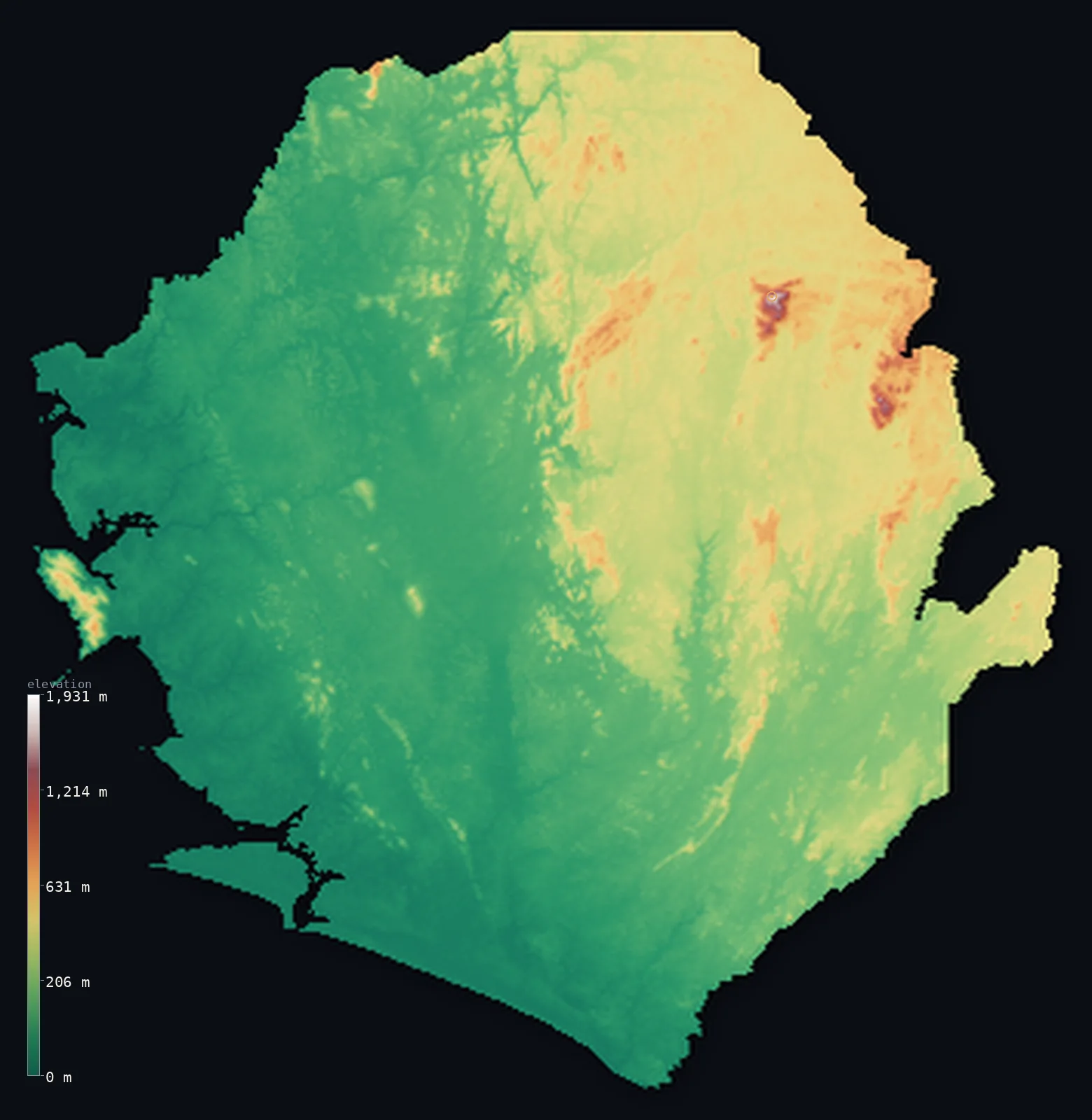
Sierra Leone’s highest point is Loma Mansa (Bintumani) at 6,391 ft (1,948 m); its lowest is Atlantic Ocean at 0 ft (0 m); the mean elevation is 646 ft (197 m).
Sierra Leone is a small West African country of low coast, plains, and one block of high mountains. Its Atlantic shore is a low belt of mangrove swamps and estuaries — broken by the hilly Freetown Peninsula, which rises to nearly 900 m straight from the sea by the capital. Inland, wooded plains climb to an interior plateau of around 300 m, and in the rugged northeast the plateau rises into the Loma Mountains, holding Loma Mansa (Bintumani) at 6,391 ft (1,948 m) — the highest peak in West Africa west of Mount Cameroon. Most of the country is low: half of it lies below about 370 ft, in the coast and plains, and the eastern mountains lift the average well above that.
- Highest point📚
- 6,391 ft1,948 m
- Sierra Leone's highest point is Loma Mansa — also called Mount Bintumani, both names meaning 'chief mountain' — at 6,391 ft (1,948 m), in the Loma Mountains of the northeastern interior. Its rainforested slopes rise abruptly above the interior plateau, and it is the highest peak in West Africa west of Mount Cameroon. It is an inland summit, not on any border; the nearby Tingi Hills (Sankanbiriwa, 1,853 m) are only a little lower.
- Lowest point📚
- 0 ft0 m
- Sierra Leone's lowest point is the Atlantic Ocean at sea level, along a low coast of mangrove swamps and estuaries among the most extensive in West Africa — broken only by the hilly Freetown Peninsula, which rises sharply from the sea by the capital. From the coast the land rises through wooded plains to an interior plateau and, in the northeast, the mountains.
- Mean elevation⚙
- 646 ft197 m
- Computed from the GLO-30 model, Sierra Leone's mean elevation is 646 ft (197 m) — but this average is lifted by the eastern mountains and sits well above the typical point: about half of Sierra Leone lies below about 367 ft (112 m), in the low coastal swamps and the wooded plains. The country is mostly low, its height concentrated in the Loma Mountains and Tingi Hills of the northeast.
- Median elevation⚙
- 367 ft112 m
- Half of Sierra Leone lies below about 367 ft (112 m) — far below the mean, because the country is mostly low: a coast of mangrove and estuary, then broad wooded plains, then an interior plateau of around 300 m. The high ground — the Loma Mountains (Loma Mansa) and the Tingi Hills in the northeast — is rugged but small in area, and it is what pulls the average up above the low majority of the land.
- Elevation range📚
- 6,391 ft1,948 m
- From the Atlantic coast to the summit of Loma Mansa at 1,948 m, Sierra Leone's terrain climbs about 6,391 ft — a wide range for a small country, from mangrove swamps and estuaries up to the highest peak in West Africa west of Mount Cameroon, though less than 1% of the land stands above 1,000 m.
- Above 1,000 m (3,281 ft)⚙
- <1%
- Less than 1% of Sierra Leone rises above 1,000 m (3,281 ft) — only the Loma Mountains and the Tingi Hills of the rugged northeast, holding Loma Mansa and Sankanbiriwa. The rest of the country — coast, plains, and interior plateau — lies well below.
- Official area📚
- 27,699 mi²71,740 km²
- Sierra Leone covers about 27,699 sq mi (71,740 sq km) — a small West African country of a low mangrove coast (with the hilly Freetown Peninsula), broad wooded plains, an interior plateau of around 300 m, and the Loma Mountains and Tingi Hills of the northeastern interior (holding Loma Mansa / Bintumani).
- Forest cover📚
- 35.1%
- About 35% of Sierra Leone is forested — rainforest on the wet slopes of the eastern mountains and the Freetown Peninsula, wooded savanna across the interior plains and plateau, and extensive mangrove forest along the estuaries of the low Atlantic coast.
Highest and lowest points
The highest point of Sierra Leone, Loma Mansa - also called Mount Bintumani, both names meaning 'chief mountain' - in the Loma Mountains of the northeastern interior. At about 1,948 m it is the highest peak in West Africa west of Mount Cameroon; some sources give 1,945 m, and a 2026 GPS survey measured about 1,942 m. Its rainforested slopes rise abruptly above the interior plateau. It is interior, not on a border. (Coordinate set to the GLO-30 summit grid-max; an earlier point ~1.7 km south read low.)
source ↗Sierra Leone's lowest point is the Atlantic Ocean at sea level, along a low coast lined with mangrove swamps and estuaries among the most extensive in West Africa. Its one interruption is the Freetown Peninsula, which rises to nearly 900 m straight out of the sea by the capital — rare hills on an otherwise flat shore, and the feature that gave the country its name, the 'Lion Mountains.' Behind the coast, wooded rolling plains climb to an interior plateau averaging around 300 m, the broad centre of the country, cut by rivers like the Rokel and the Sewa. In the rugged northeast the plateau rises into the Loma Mountains — holding Loma Mansa (Bintumani), the highest point, where the Rokel and Sewa rivers rise — and the Tingi Hills (Sankanbiriwa). So Sierra Leone climbs from a low mangrove coast, across plains and plateau, to a small block of high mountains in the far northeast.
source ↗Sierra Leone at a glance
Loma Mansa (Bintumani), 1,948 m, is the highest mountain in West Africa west of Mount Cameroon.
source ↗Its two names, Loma Mansa and Bintumani, both mean 'chief mountain' in local languages.
source ↗The Freetown Peninsula rises to nearly 900 m straight out of the sea - rare hills on an otherwise low coast.
source ↗Sierra Leone's main rivers, the Rokel and Sewa, both rise in the Loma Mountains.
source ↗The coast is lined with mangrove swamps and estuaries, among the most extensive in West Africa.
source ↗
Elevation profile of Sierra Leone
The largest share of land, 62%, falls in the 0–200 m band, and 94% of the territory lies below 500 m (1,640 ft).
- below 500 m (1,640 ft)94%
- 500–1,000 m6%
- 1,000–2,000 m<1%
Highest peaks of Sierra Leone
| Peak | Elevation | Range | Note |
|---|---|---|---|
| Loma Mansa (Bintumani)↗ | 6,391 ft1,948 m | Loma Mountains | Highest point of Sierra Leone and of West Africa west of Mount Cameroon. |
| Sankanbiriwa↗ | 6,079 ft1,853 m | Tingi Hills | The high point of the Tingi Hills, the second major massif of the eastern interior. |
| Picket Hill↗ | 2,913 ft888 m | Freetown Peninsula Mountains | The highest of the wooded hills on the Freetown Peninsula behind the capital. |
Sierra Leone: the mangrove coast, the interior plains and plateau, and the eastern mountains
The coast and Freetown Peninsula
A low belt of mangrove swamps and estuaries along the Atlantic, among the most extensive in West Africa — with the hilly Freetown Peninsula rising sharply from it by the capital and its great harbour.
The interior plains and plateau
Inland from the coast, wooded rolling plains give way to an interior plateau averaging around 300 m — the broad heart of the country, cut by rivers like the Rokel and the Sewa.
The eastern mountains
The rugged northeast, where the plateau climbs into the Loma Mountains (Loma Mansa / Bintumani) and the Tingi Hills (Sankanbiriwa) — the country's high, rainforested ground, where its main rivers rise.
How to read this map
Color shows elevation; the raised relief shows real terrain. On this map Sierra Leone reads as a mostly low country with one high corner — the low green of the mangrove coast and the wooded plains covering most of it, the steep hills of the Freetown Peninsula on the coast, and the browns of the Loma Mountains and Tingi Hills rising in the rugged northeast (highest at Loma Mansa).
With most of the country low, the 3D exaggeration is what makes the eastern mountains and the Freetown hills stand out; the ×N relief slider controls how much. Tap anywhere to read that point's exact elevation.
City elevations in Sierra Leone
Sierra Leone's largest city is Freetown, the capital, on its mountainous peninsula and great natural harbour on the Atlantic coast, with Bo, Kenema, Koidu, and Makeni across the interior plains and plateau, and Kabala in the north toward the mountains. Most of the population lives low, on the coast and in the plains.
| City | Population | Elevation |
|---|---|---|
| Freetowncapitalthe capital, on the mountainous peninsula and its Atlantic harbour ↗ | 802,639 | 118 ft36 m |
| Kenemain the southeast, toward the eastern highlands ↗ | 255,110 | 577 ft176 m |
| Boin the southern interior plains ↗ | 233,684 | 325 ft99 m |
| Koiduin the east, in the diamond country ↗ | 128,030 | 1,243 ft379 m |
| Makeniin the north-central interior ↗ | 85,116 | 302 ft92 m |
| Port Lokoin the northwest, near the coastal estuaries ↗ | 44,900 | 154 ft47 m |
| Njala | 40,000 | 197 ft60 m |
| Kabalain the north, toward the Loma Mountains ↗ | 17,948 | 1,417 ft432 m |
| Mile 91 | 15,491 | 262 ft80 m |
| Kailahun | 14,085 | 984 ft300 m |
Elevation sampled at each city centre from the Copernicus GLO-30 model. Cities and population from GeoNames (CC-BY 4.0).
Sierra Leone in comparison
Sierra Leone's terrain rises 6,391 ft (1,948 m) from sea level to Loma Mansa (Bintumani) — about 22% of the height of Mount Everest, the world's highest point at 29,032 ft (8,849 m).
- Guinea's mean elevation is 1,447 ft — 801 ft higher; its high point, Mount Nimba (Mont Richard-Molard), reaches 5,748 ft (1,752 m), 643 ft below. Guinea elevation map →
- Liberia's mean elevation is 705 ft — 59 ft higher; its high point, Mount Wuteve, reaches 4,747 ft (1,447 m), 1,644 ft below. Liberia elevation map →
- Côte d'Ivoire's mean elevation is 853 ft — 207 ft higher; its high point, Mont Nimba (Mount Richard-Molard), reaches 5,748 ft (1,752 m), 643 ft below. Côte d'Ivoire elevation map →
Frequently asked questions
What is the highest point in Sierra Leone?
- Loma Mansa, also called Bintumani, 6,391 ft (1,948 m), in the Loma Mountains of the northeastern interior - the highest peak in West Africa west of Mount Cameroon.
What is the lowest point in Sierra Leone?
- The Atlantic Ocean at sea level, along a low coast of mangrove swamps and estuaries, broken by the hilly Freetown Peninsula.
What is the average elevation of Sierra Leone?
- No standard source publishes one, so this page reports the mean computed from the Copernicus GLO-30 model, 646 ft (197 m). It is lifted by the eastern mountains; about half the country lies below about 367 ft (112 m), in the low coast and plains.
Why does Bintumani have two names?
- Loma Mansa and Bintumani are names in different local languages, both meaning 'chief mountain'; the nearest village uses Bintumani.
How high are the hills behind Freetown?
- The Freetown Peninsula rises to nearly 900 m, with Picket Hill (888 m) the highest - steep wooded hills straight above the coast and the harbour.
Is this a topographic, relief, contour, or elevation map of Sierra Leone?
- They describe the same thing - terrain height. This page renders Sierra Leone's actual elevation surface in interactive 3D and reports the statistics computed from it.
About this map
The terrain is rendered from the Copernicus GLO-30 digital elevation model (ESA), masked to the SLE-ADM0 boundary from geoBoundaries (gbOpen). Elevation statistics are computed directly from the model; peak names and researched facts are sourced and cited. See the methodology for the full pipeline.
Our area-weighted mean, computed from the Copernicus GLO-30 model, is 646 ft (197 m); no authority publishes a mean elevation (No authoritative published mean elevation). Sierra Leone is mostly a low country with its height gathered in one rugged corner. A coast of mangrove swamps and estuaries — broken by the steep hills of the Freetown Peninsula — gives way inland to wooded plains and an interior plateau of around 300 m, the broad heart of the country. Only in the northeast does the plateau climb into real mountains: the Loma Mountains, holding Loma Mansa (Bintumani), the highest peak in West Africa west of Mount Cameroon, and the Tingi Hills beside them. These highlands are high but small in area, so they lift the mean well above the typical point, while half of Sierra Leone lies below about 367 ft (112 m), in the low coast and plains. No standard source publishes a mean elevation for Sierra Leone; the figure here is computed directly from the GLO-30 surface.
Surveyed national figures: official area · forest cover · high point.
Rendered from Copernicus GLO-30 (ESA, 2021 release), boundaries from geoBoundaries. Generated 2026-06-26.
Bordering countries · 2
Sierra Leone shares a land border with these countries — open any one to compare its terrain and highest point.