Liberia Elevation Map — Topographic & 3D Terrain
Explore the terrain of Liberia in interactive 3D, built from Copernicus GLO-30 satellite elevation data — a low, forested Atlantic country rising from the coast to the mountains of the northwest. Drag to rotate, scroll to zoom, and tap any point to read its elevation.
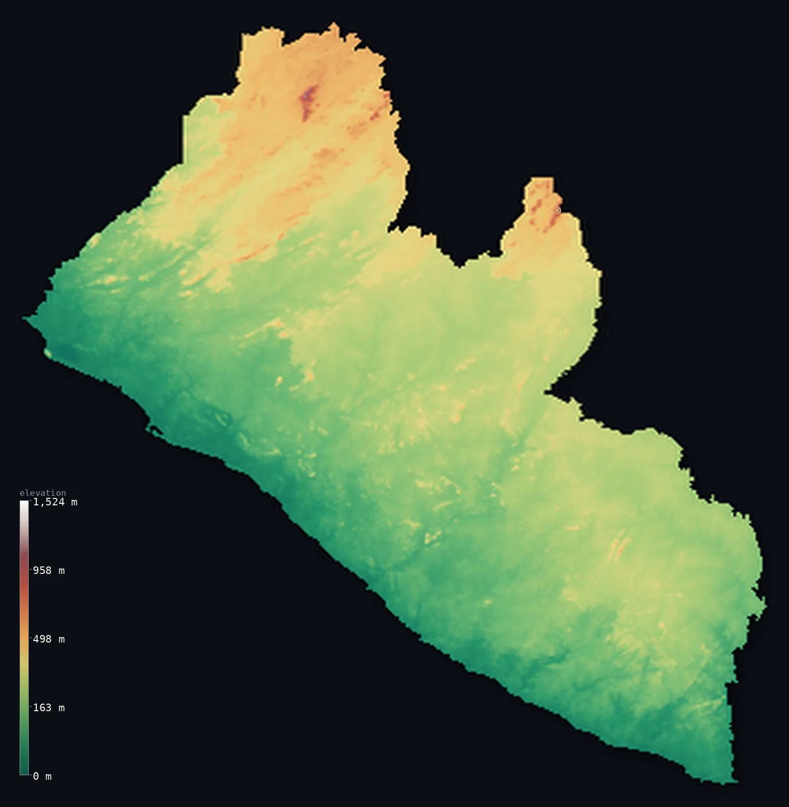
Liberia’s highest point is Mount Wuteve at 4,747 ft (1,447 m); its lowest is Atlantic Ocean at 0 ft (0 m); the mean elevation is 705 ft (215 m).
Liberia is a low, densely forested country on the West African Atlantic coast, between Sierra Leone and Ivory Coast. From a coastal belt of creeks, lagoons, and mangrove — where the capital Monrovia and most of the population live — the land rises through rainforested hills to a dissected interior plateau, the bulk of the country. Real mountains appear only in the far north and northwest: the Wologizi Range, holding the highest point, Mount Wuteve, at 4,747 ft (1,447 m), and, on the Guinea border, Mount Nimba, whose summit (1,752 m) is higher but lies just across the frontier. Liberia is low and even: half of it lies below about 680 ft, and less than 1% reaches 1,000 m.
- Highest point📚
- 4,747 ft1,447 m
- Liberia's highest point is Mount Wuteve at 4,747 ft (1,447 m), an interior summit of the Wologizi Range in the northwest (Lofa County) — the highest ground wholly within the country. Nearby Mount Nimba, on the Guinea and Ivory Coast border, has a higher summit (1,752 m), but its peak lies just outside Liberia, so Wuteve is Liberia's own high point. Older maps gave 1,380 m; satellite (SRTM) data revised Wuteve upward.
- Lowest point📚
- 0 ft0 m
- Liberia's lowest point is the Atlantic Ocean at sea level, along a low coastal belt of tidal creeks, lagoons, and mangrove marshes where the capital, Monrovia, and most of the population live. From this coast the land rises inland through low hills to a forested interior plateau, and, in the far north and northwest, to Liberia's only mountains.
- Mean elevation⚙
- 705 ft215 m
- Computed from the GLO-30 model, Liberia's mean elevation is 705 ft (215 m) — low, for Liberia is mostly a country of coastal plain and forested plateau: the land rises gently from the Atlantic to a dissected interior of 300–600 m, with real mountains only in the far north and northwest. About half the country lies below about 679 ft (207 m), and the mean sits close by — Liberia is low and even, its high ground confined to one corner.
- Median elevation⚙
- 679 ft207 m
- Half of Liberia lies below about 679 ft (207 m) — a low figure close to the mean, because most of the country is low: a coastal plain, then rainforested hills and a plateau that make up the bulk of the land. Only the Wologizi and Nimba highlands of the north and northwest rise well above, and they are a small part of a low, forested country.
- Elevation range📚
- 4,747 ft1,447 m
- From the Atlantic coast to the summit of Mount Wuteve at 1,447 m, Liberia's terrain climbs about 4,747 ft — but the rise is gentle and the high ground confined to the northwest: most of Liberia is low coastal plain and forested plateau, and less than 1% of it stands above 1,000 m.
- Above 1,000 m (3,281 ft)⚙
- <1%
- Less than 1% of Liberia rises above 1,000 m (3,281 ft) — only the Wologizi and Nimba highlands in the far north and northwest, holding Mount Wuteve and, on the border, Mount Nimba. Nearly all of the country lies well below, in coastal plain and forested plateau.
- Official area📚
- 43,000 mi²111,369 km²
- Liberia covers about 43,000 sq mi (111,369 sq km) — a West African Atlantic country between Sierra Leone and Ivory Coast, of a low coastal plain, a broad rainforested interior plateau, and mountains only in the north and northwest (the Wologizi Range, holding Mount Wuteve, and the Nimba Range on the Guinea border).
- Forest cover📚
- 79%
- About 79% of Liberia is forested — among the highest forest cover of any African country: the land holds the largest remaining block of the Upper Guinean Atlantic lowland rainforest, home to the rare pygmy hippopotamus, drained by six rivers running to the sea.
Highest and lowest points
The highest point of Liberia at about 1,447 m - Mount Wuteve (Wologizi), an interior summit of the Wologizi Range in the northwest (Lofa County). Older figures gave 1,380 m; SRTM data revised it upward. Mount Nimba's summit (1,752 m) on the Guinea/Ivory Coast border is higher, but its peak lies outside Liberia, so Wuteve is the highest point wholly within the country. Coordinates are approximate.
source ↗Liberia's lowest point is the Atlantic Ocean at sea level, along a coastal plain about 40 km wide of tidal creeks, lagoons, and mangrove marshes, holding the capital, Monrovia, and most of the population. All six of Liberia's major rivers run down to this coast, though sandbars across their mouths make them hard to enter from the sea. Inland, the land rises through low hills to a dissected interior plateau of 300–600 m, cloaked in rainforest — the great bulk of the country, and part of the largest surviving block of Upper Guinean lowland forest. Only in the north and northwest does Liberia reach real height: the Wologizi Range, holding Mount Wuteve, the country's highest point, and the Wonegizi Range beside it; and, on the Guinea border in the northeast, the Nimba Range — a UNESCO World Heritage site shared by Liberia, Guinea, and Ivory Coast, whose summit (1,752 m) tops Wuteve but lies just across the frontier. Liberia is low and forested throughout, its mountains a small edge in the far north.
source ↗Liberia at a glance
Liberia's highest point was only settled in the 2000s: SRTM satellite data showed Mount Wuteve in the northwest is higher than Mount Nimba, the long-assumed highest.
source ↗Mount Nimba's summit (1,752 m) would top Wuteve, but it lies on the Guinea-Ivory Coast border, so it is not Liberia's highest point.
source ↗Liberia holds the largest remaining block of the Upper Guinean Atlantic lowland rainforest, home to the rare pygmy hippopotamus.
source ↗All six of Liberia's major rivers run roughly perpendicular to the coast, but sandbars across their mouths make them hard to enter from the sea.
source ↗Forest covers roughly four-fifths of Liberia, among the highest forest cover of any African country.
source ↗The Nimba Range on the Guinea border is a UNESCO World Heritage site shared by Liberia, Guinea and Ivory Coast.
source ↗
Elevation profile of Liberia
The largest share of land, 31%, falls in the 200–300 m band, and 96% of the territory lies below 500 m (1,640 ft).
- below 500 m (1,640 ft)96%
- 500–1,000 m4%
- 1,000–2,000 m<1%
Highest peaks of Liberia
| Peak | Elevation | Range | Note |
|---|---|---|---|
| Mount Nimba↗ | 5,748 ft1,752 m | Nimba Range (Guinea / Ivory Coast border, northeast) | Its summit (1,752 m) sits on the Guinea-Ivory Coast border; Liberia's slopes reach about 1,362 m, just below Wuteve. |
| Mount Wuteve↗ | 4,747 ft1,447 m | Wologizi Range (northwest) | Highest point of Liberia, an interior summit of the Wologizi Range in Lofa County, confirmed highest by SRTM data. |
| Wonegizi Range (high ground)↗ | 3,937 ft1,200 m | Wonegizi Range (northwest) | A forested northwestern range exceeding 1,000 m, adjoining the Wologizi near the Guinea border. |
Liberia: the coastal plain, the forested plateau, and the northern mountains
The coastal plain
A low Atlantic belt about 40 km wide of tidal creeks, lagoons, and mangrove marshes, holding the capital Monrovia and most of the population. The country's low, populous seaward edge.
The hills and interior plateau
Low hills behind the coast rising to a dissected plateau of 300–600 m — the bulk of the country — cut by the six main rivers and cloaked in Upper Guinean rainforest.
The northern and Nimba highlands
The higher ground of the north and northwest — the Wologizi Range (with Mount Wuteve) and Wonegizi Range, and the Nimba Range on the Guinea border, shared with Guinea and Ivory Coast. The country's only real mountains.
How to read this map
Color shows elevation; the raised relief shows real terrain. On this map Liberia reads as a low, green country — a broad expanse of low-to-middle tone, the coastal plain and the rainforested interior plateau covering nearly all of it, rising only in the far north and northwest to the browns of the Wologizi and Nimba mountains (highest at Mount Wuteve).
Because the country is largely low, the 3D exaggeration is what makes the northern mountains stand out; the ×N relief slider controls how much. Tap anywhere to read that point's exact elevation.
City elevations in Liberia
Liberia's cities cluster on the coast and along the roads inland — Monrovia, the capital, on the Atlantic, with the port of Buchanan to the southeast, and Gbarnga, Ganta, and Kakata in the forested interior toward the northern mountains. Most of the population lives low, near the coast.
| City | Population | Elevation |
|---|---|---|
| Monroviacapitalthe capital, on the Atlantic coast ↗ | 1,542,549 | 89 ft27 m |
| Gbarngain the central interior ↗ | 86,031 | 817 ft249 m |
| Buchanana port on the southeast coast ↗ | 75,854 | 30 ft9 m |
| Gantain the north, near the Guinea border below the Nimba Range ↗ | 63,523 | 925 ft282 m |
| Kakatain the interior north of Monrovia ↗ | 52,247 | 295 ft90 m |
| Zwedruin the forested southeast ↗ | 38,269 | 719 ft219 m |
| Harperon the far southeastern coast ↗ | 35,503 | 30 ft9 m |
| Foya Kamara | 31,052 | 1,519 ft463 m |
| New Yekepain the north, in the Nimba iron-ore country ↗ | 24,695 | 1,677 ft511 m |
| Voinjamain the northwest, near the Wologizi Range ↗ | 23,051 | 1,795 ft547 m |
Elevation sampled at each city centre from the Copernicus GLO-30 model. Cities and population from GeoNames (CC-BY 4.0).
Liberia in comparison
Liberia's terrain rises 4,747 ft (1,447 m) from sea level to Mount Wuteve — about 16% of the height of Mount Everest, the world's highest point at 29,032 ft (8,849 m).
- Sierra Leone's mean elevation is 646 ft — 59 ft lower; its high point, Loma Mansa (Bintumani), reaches 6,391 ft (1,948 m), 1,644 ft above. Sierra Leone elevation map →
- Guinea's mean elevation is 1,447 ft — 741 ft higher; its high point, Mount Nimba (Mont Richard-Molard), reaches 5,748 ft (1,752 m), 1,001 ft above. Guinea elevation map →
- Côte d'Ivoire's mean elevation is 853 ft — 148 ft higher; its high point, Mont Nimba (Mount Richard-Molard), reaches 5,748 ft (1,752 m), 1,001 ft above. Côte d'Ivoire elevation map →
Frequently asked questions
What is the highest point in Liberia?
- Mount Wuteve, about 4,747 ft (1,447 m), in the Wologizi Range of the northwest - the highest point wholly within Liberia.
Is Mount Nimba the highest point in Liberia?
- No - Mount Nimba's 1,752 m summit sits on the Guinea-Ivory Coast border, just outside Liberia. Liberia's own highest point is Mount Wuteve (about 1,447 m) in the northwest; Nimba is the higher, shared border summit.
What is the average elevation of Liberia?
- Computed from the Copernicus GLO-30 model, the area-weighted mean is 705 ft (215 m). Liberia is mostly low coastal plain and forested plateau, so the mean and median (about 679 ft (207 m)) sit close together, with mountains only in the northwest.
How much of Liberia is forest?
- About four-fifths - among the highest forest cover of any African country. Liberia holds the largest remaining block of the Upper Guinean Atlantic lowland rainforest, home to the rare pygmy hippopotamus.
Where are the mountains in Liberia?
- In the north and northwest - the Wologizi Range (with Mount Wuteve) and Wonegizi Range, and the Nimba Range on the Guinea border in the northeast, shared with Guinea and Ivory Coast.
Is this a topographic, relief, contour, or elevation map of Liberia?
- They describe the same thing - terrain height. This page renders Liberia's actual elevation surface in interactive 3D and reports the statistics computed from it.
About this map
The terrain is rendered from the Copernicus GLO-30 digital elevation model (ESA), masked to the LBR-ADM0 boundary from geoBoundaries (gbOpen). Elevation statistics are computed directly from the model; peak names and researched facts are sourced and cited. See the methodology for the full pipeline.
Our area-weighted mean, computed from the Copernicus GLO-30 model, is 705 ft (215 m); the figure commonly cited elsewhere is 797 ft (243 m) (CIA World Factbook). Liberia is a low, densely forested country whose high ground is gathered in one corner. From the Atlantic, a coastal belt of creeks, lagoons, and mangrove gives way to rainforested hills and a dissected interior plateau of 300–600 m — the bulk of the country. Only in the far north and northwest does the land rise to real mountains: the Wologizi Range, holding the high point, Mount Wuteve, and, on the Guinea border, the Nimba Range, whose summit (1,752 m) is higher than Wuteve but stands just outside Liberia. So half of Liberia lies below about 679 ft (207 m), close to the mean; less than a hundredth of it reaches 1,000 m. It is a low forest country, its heights a small northwestern edge.
Surveyed national figures: official area · forest cover · high point.
Rendered from Copernicus GLO-30 (ESA, 2021 release), boundaries from geoBoundaries. Generated 2026-06-23.
Bordering countries · 3
Liberia shares a land border with these countries — open any one to compare its terrain and highest point.