Côte d'Ivoire Elevation Map — Topographic & 3D Terrain
Explore the terrain of Côte d'Ivoire in interactive 3D, built from Copernicus GLO-30 satellite elevation data — a low West African country of coastal lagoons, southern forest, and northern savanna, rising to highlands in the northwest. Drag to rotate, scroll to zoom, and tap any point to read its elevation.
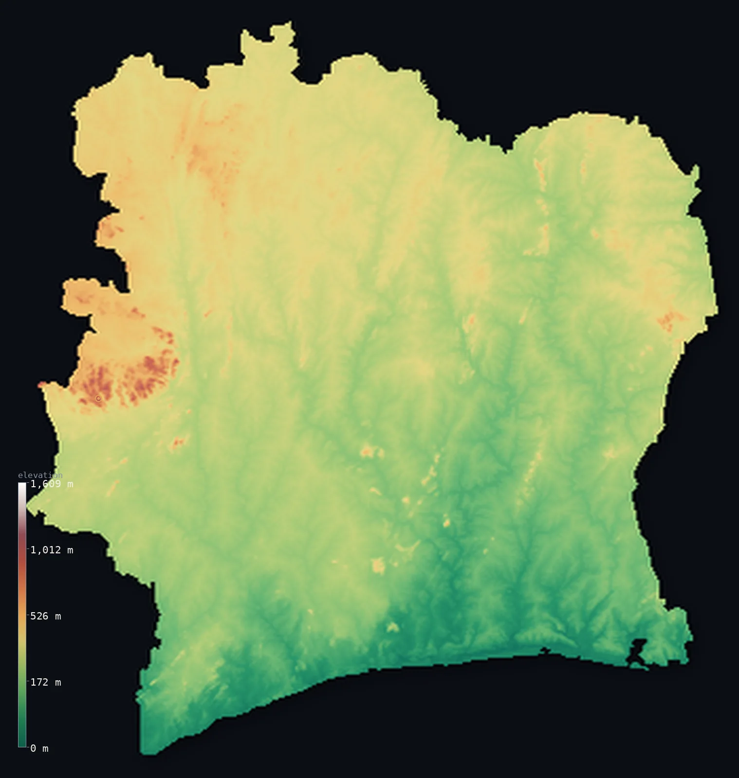
Côte d'Ivoire’s highest point is Mont Nimba (Mount Richard-Molard) at 5,748 ft (1,752 m); its lowest is Gulf of Guinea (Atlantic Ocean) at 0 ft (0 m); the mean elevation is 853 ft (260 m).
Côte d'Ivoire is a mostly low country on the Gulf of Guinea. A low, lagoon-fringed coast in the south gives way inland to a broad forested plateau, and then to open savanna across the north — a gentle south-to-north rise across most of the country. Only in the far west and northwest does the land climb into real highlands, reaching the country's highest point at Mont Nimba, 5,748 ft (1,752 m), where the borders of Côte d'Ivoire, Guinea, and Liberia meet. Most of Côte d'Ivoire, though, is low plateau and plain.
- Highest point📚
- 5,748 ft1,752 m
- Côte d'Ivoire's highest point is Mont Nimba at 5,748 ft (1,752 m), in the far northwest at the meeting point of Côte d'Ivoire, Guinea, and Liberia — the summit of a range shared between the three countries. The peak itself stands right at the tripoint, just beyond the border; the highest ground fully within Côte d'Ivoire, on the range's slopes, is somewhat lower, at 5,279 ft (1,609 m). Mont Nimba, a forested massif famous for its unique wildlife, is far higher than anything else in this mostly low country.
- Lowest point📚
- 0 ft0 m
- Côte d'Ivoire's lowest point is the sea, where the Gulf of Guinea meets a low, lagoon-laced shore — sandbars and the great Ébrié Lagoon around Abidjan, backed by coastal plains and forest.
- Mean elevation⚙
- 853 ft260 m
- Computed from the GLO-30 model, Côte d'Ivoire's mean elevation is 853 ft (260 m) — low, because the country is essentially one broad plateau tilting gently from the northern savanna down to the lagoon coast, with real high ground only in the far northwest at Mont Nimba.
- Median elevation⚙
- 840 ft256 m
- Half of Côte d'Ivoire lies below about 840 ft (256 m), barely different from the mean — the mark of a country almost entirely at one gentle plateau level, its coastal plains, forest, and savanna all low, with the far-northwestern highlands too small to shift the middle.
- Elevation range📚
- 5,748 ft1,752 m
- Côte d'Ivoire's terrain spans about 5,750 ft in all, from the Atlantic to Mont Nimba at 1,752 m — but almost the whole span sits in the far-northwestern corner. Take away Nimba and the country is nearly flat, a gentle plateau climbing only from sea level to a few hundred metres of northern savanna.
- Above 1,000 m (3,281 ft)⚙
- <1%
- Less than 1% of Côte d'Ivoire rises above 1,000 m (3,281 ft) — only the far northwest, at Mont Nimba, climbs that high. Most of the country is low plateau and plain; about 70% of it lies above 200 m, the gentle interior rise above the coastal lowlands.
- Official area📚
- 124,504 mi²322,463 km²
- Côte d'Ivoire covers about 124,500 sq mi (322,463 sq km) — a West African country on the Gulf of Guinea, mostly low plateau and plain, with a lagoon coast, southern forest, and northern savanna, rising to highlands only in the far northwest at Mont Nimba.
- Forest cover📚
- 32.7%
- About 33% of Côte d'Ivoire is forested — moist tropical forest through the south (long the source of the world's largest cocoa crop), thinning to wooded savanna and grassland across the north, with montane forest on the northwestern heights.
Highest and lowest points
Côte d'Ivoire's highest point is Mont Nimba, 5,748 ft (1,752 m), in the far northwest where the borders of Côte d'Ivoire, Guinea, and Liberia meet. It is the summit of the Nimba Range, a forested massif shared between the three countries — and one of the most famous wildlife sites in West Africa, a UNESCO site known for its endemic species. The summit itself stands at the tripoint, just beyond Côte d'Ivoire's border; the highest ground fully within the country, on the range's eastern slopes, reaches about 5,279 ft (1,609 m). Mont Nimba rises far above the rest of Côte d'Ivoire, whose terrain is otherwise low plateau and plain — the one corner where the country climbs into true highlands.
source ↗Côte d'Ivoire's lowest point is the Atlantic Ocean at sea level, along the Gulf of Guinea coast — a low shore of sandbars and lagoons, including the great Ébrié Lagoon around Abidjan, backed by coastal plains and forest. From this low coast the land rises gently inland: across the broad forested plateau of the south and centre, and on into the savanna of the north. The rivers — the Bandama, the Comoé, the Sassandra, the Cavally — run down this gentle slope from north to south, reaching the sea across the coastal lowlands.
source ↗Mont Nimba (Mount Richard-Molard) is a border summit: its peak lies about 1 km outside the generalized Côte d'Ivoire boundary, so the highest fully in-territory land pixel in the model is 5,279 ft (1,609 m). The headline figure above is the surveyed elevation of the recognised national high point.
Côte d'Ivoire at a glance
Côte d'Ivoire's highest point, Mont Nimba (1,752 m), is the joint summit of both Côte d'Ivoire and Guinea — it sits right on their border, while the wider massif meets the Guinea–Liberia–Côte d'Ivoire tripoint.
source ↗Almost the whole country is a single low plateau, tilting so gently from the northern savanna (~500 m) down to the Atlantic that it has barely any relief outside the far west.
source ↗Mont Nimba lies in a UNESCO World Heritage strict nature reserve famed for its biodiversity — yet the same slopes hold rich iron-ore and cobalt deposits that threaten its protection.
source ↗A 300 km chain of shallow lagoons lines the southeastern coast, sealed off from the sea by sandbars — Abidjan is built among them.
source ↗The country's vegetation shifts in clear belts from south to north: rainforest, then the Guinean forest–savanna mosaic, then open Sudanian savanna.
source ↗Mont Nimba was renamed after the French geographer Jacques Richard-Molard, who died on the mountain in 1951; its older name was Mount Nouon.
source ↗
Elevation profile of Côte d'Ivoire
The largest share of land, 33%, falls in the 200–300 m band, and 97% of the territory lies below 500 m (1,640 ft).
- below 500 m (1,640 ft)97%
- 500–1,000 m3%
- 1,000–2,000 m<1%
Highest peaks of Côte d'Ivoire
| Peak | Elevation | Range | Note |
|---|---|---|---|
| Mont Nimba (Mount Richard-Molard)↗ | 5,748 ft1,752 m | Nimba Range (Guinea Highlands) | Highest point of Côte d'Ivoire, on the Guinea border, in the Mount Nimba Strict Nature Reserve. |
| Dix-Huit Montagnes (high ground near Man)↗ | 3,937 ft1,200 m | Dix-Huit Montagnes (western highlands) | The 'Eighteen Mountains' region around Man in the west, with peaks above 1,000 m — the country's main relief outside Nimba. |
| Man highlands (Guinean montane forest)↗ | 3,281 ft1,000 m | western highlands | The forested hills around Man, part of the Guinean montane forests, the wettest, most rugged corner of the country. |
| Northern savanna plateau (high ground)↗ | 1,640 ft500 m | northern plateau | The gently rising plateau of the north, in the West Sudanian savanna belt, reaching around 500 m. |
| Central plateau↗ | 984 ft300 m | central plateau | The broad central plateau of the forest–savanna mosaic, the gently tilted heart of the country. |
Côte d'Ivoire: the lagoon coast, the forested plateau, and the western highlands
The coast and lagoons (the south)
Along the Gulf of Guinea runs a low coast of sandbars and lagoons — the Ébrié Lagoon around Abidjan among them — backed by coastal plains and forest. A low, warm, water-laced shore holding the country's largest city.
The forested plateau and savanna (the centre and north)
Inland the land rises gently into a broad plateau — moist forest through the south and centre (the cocoa country), giving way to wooded savanna across the north. Low, rolling, and covering most of the country, it is the Ivorian heartland.
The western highlands
In the far west and northwest the land climbs into highlands — the Nimba Range at the Guinea-Liberia tripoint (holding Mont Nimba, the high point) and the Man mountains, of forested peaks and waterfalls. The country's only true high ground, far above the plateau.
How to read this map
Color shows elevation; the raised relief shows real terrain. On this map Côte d'Ivoire reads as a low country with one high corner — low greens along the lagoon coast and across the broad forested and savanna plateau that fills most of the country, rising gently from south to north, with a knot of higher browns only in the far northwest, at the Nimba Range and the Man mountains on the Guinea-Liberia border.
The 3D relief is the actual GLO-30 elevation data, exaggerated vertically so the gentle slope and the northwestern highlands both show; the ×N relief slider controls how much. Tap anywhere to read that point's exact elevation.
City elevations in Côte d'Ivoire
Côte d'Ivoire's cities spread from the coast inland — Abidjan, the largest, on its lagoon by the Gulf of Guinea, Yamoussoukro, the capital, in the centre, Bouaké in the central savanna, and Korhogo in the north. The coast and the interior plateau both hold major cities.
| City | Population | Elevation |
|---|---|---|
| Abidjanthe largest city, on the Ébrié Lagoon by the Gulf of Guinea ↗ | 6,321,017 | 174 ft53 m |
| Bouakéin the central savanna ↗ | 832,371 | 1,109 ft338 m |
| Korhogoin the northern savanna ↗ | 440,926 | 1,181 ft360 m |
| Daloain the west-central forest belt ↗ | 421,871 | 860 ft262 m |
| San-Pédroa southwestern port on the Gulf of Guinea ↗ | 390,654 | 13 ft4 m |
| Gagnoain the south-central forest ↗ | 277,044 | 656 ft200 m |
| Yamoussoukrocapitalthe capital, in the centre of the country ↗ | 275,686 | 689 ft210 m |
| Manin the western highlands, among the Man mountains ↗ | 241,969 | 1,079 ft329 m |
| Bondoukouin the northeast, near the Ghana border ↗ | 141,568 | 1,161 ft354 m |
| Divoin the south-centre ↗ | 136,627 | 482 ft147 m |
Elevation sampled at each city centre from the Copernicus GLO-30 model. Cities and population from GeoNames (CC-BY 4.0).
Côte d'Ivoire in comparison
Côte d'Ivoire's terrain rises 5,748 ft (1,752 m) from sea level to Mont Nimba (Mount Richard-Molard) — about 20% of the height of Mount Everest, the world's highest point at 29,032 ft (8,849 m).
- Ghana's mean elevation is 591 ft — 262 ft lower; its high point, Leklata, reaches 2,953 ft (900 m), 2,795 ft below. Ghana elevation map →
- Guinea's mean elevation is 1,447 ft — 594 ft higher; its high point, Mount Nimba (Mont Richard-Molard), reaches 5,748 ft (1,752 m), 0 ft above. Guinea elevation map →
- Liberia's mean elevation is 705 ft — 148 ft lower; its high point, Mount Wuteve, reaches 4,747 ft (1,447 m), 1,001 ft below. Liberia elevation map →
- Mali's mean elevation is 1,043 ft — 190 ft higher; its high point, Hombori Tondo, reaches 3,789 ft (1,155 m), 1,959 ft below. Mali elevation map →
Frequently asked questions
What is the highest point in Côte d'Ivoire?
- Mont Nimba, 5,748 ft (1,752 m), at the tripoint where Côte d'Ivoire, Guinea, and Liberia meet — a forested massif famous for its wildlife. The summit is at the border; the highest ground fully inside the country is about 1,609 m.
What is the lowest point in Côte d'Ivoire?
- The Atlantic Ocean at sea level, along the Gulf of Guinea coast, around the lagoons of Abidjan.
What is the average elevation of Côte d'Ivoire?
- Computed from the Copernicus GLO-30 model, the area-weighted mean is 853 ft (260 m) — low, because the country is mostly low plateau and plain, with real highlands only in the far northwest.
What is Mont Nimba?
- A forested massif at the Côte d'Ivoire–Guinea–Liberia tripoint, holding the country's highest point (1,752 m) — a UNESCO World Heritage Site famous for endemic wildlife found nowhere else.
Is Côte d'Ivoire mountainous?
- Mostly not — it is a low country of coastal plains, forested plateau, and northern savanna, with true highlands only in the far northwest around Mont Nimba (1,752 m) and the Man mountains.
Is this a topographic, relief, contour, or elevation map of Côte d'Ivoire?
- They describe the same thing — terrain height. This page renders the country's actual elevation surface in interactive 3D and reports the statistics computed from it.
About this map
The terrain is rendered from the Copernicus GLO-30 digital elevation model (ESA), masked to the CIV-ADM0 boundary from geoBoundaries (gbOpen). Elevation statistics are computed directly from the model; peak names and researched facts are sourced and cited. See the methodology for the full pipeline.
Our area-weighted mean, computed from the Copernicus GLO-30 model, is 853 ft (260 m); the figure commonly cited elsewhere is 820 ft (250 m) (CIA World Factbook). Côte d'Ivoire is mostly a low plateau tilting gently from sea level in the south to around 500 m in the north, with real mountains only in the far west, so the mean elevation is low; the page reports the area-weighted figure computed from the Copernicus GLO-30 model.
Surveyed national figures: official area · forest cover · high point.
Rendered from Copernicus GLO-30 (ESA, 2021 release), boundaries from geoBoundaries. Generated 2026-06-22.
Bordering countries · 5
Côte d'Ivoire shares a land border with these countries — open any one to compare its terrain and highest point.