Ghana Elevation Map — Topographic & 3D Terrain
Explore the terrain of Ghana in interactive 3D, built from Copernicus GLO-30 satellite elevation data — a low West African country of coastal plains, forest, and northern savanna around the vast Lake Volta. Drag to rotate, scroll to zoom, and tap any point to read its elevation.
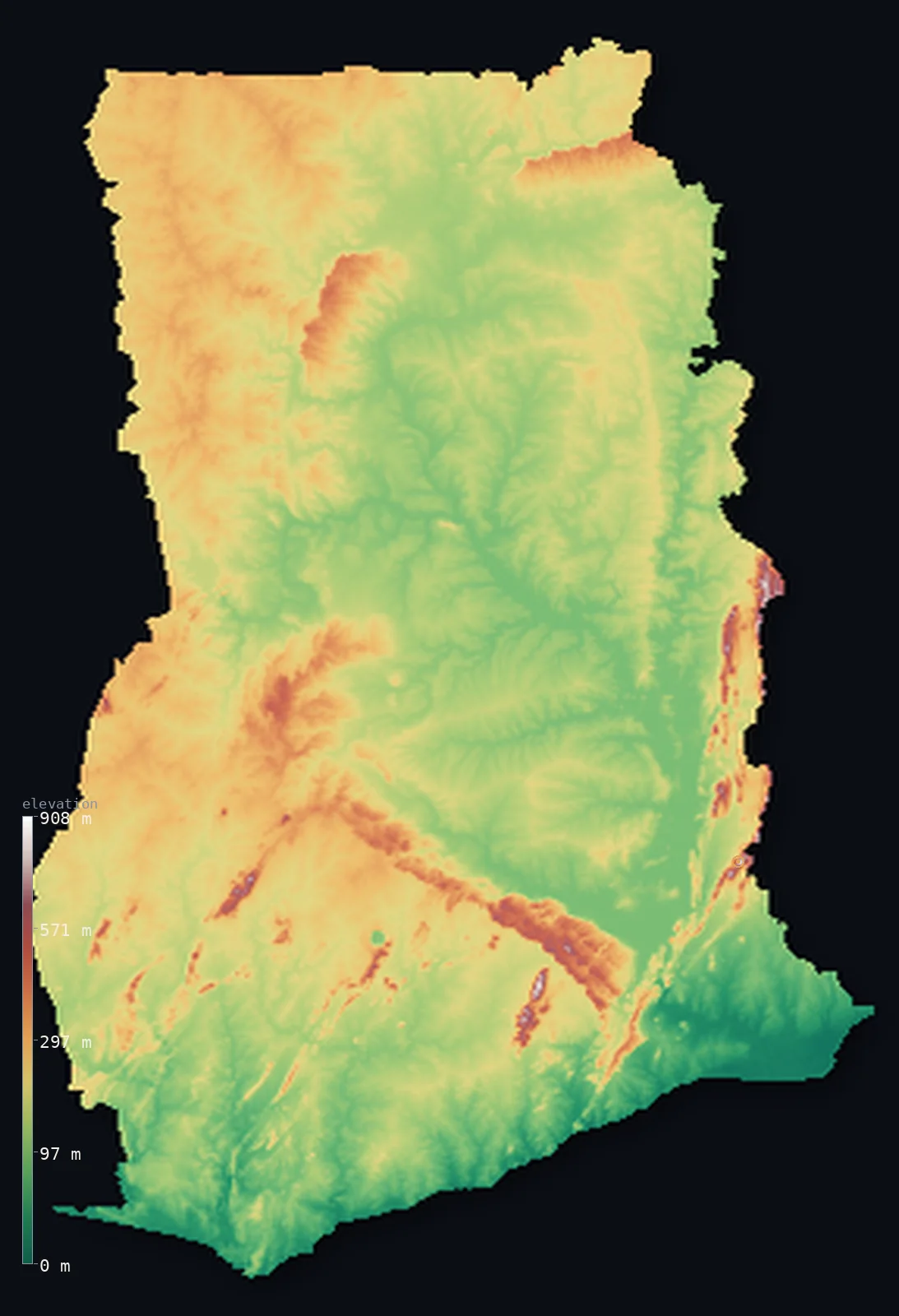
Ghana’s highest point is Leklata at 2,953 ft (900 m); its lowest is Gulf of Guinea (Atlantic Ocean) at 0 ft (0 m); the mean elevation is 591 ft (180 m).
Ghana is a low country on the Gulf of Guinea. Most of it lies below 1,000 ft — a low, gently rolling land of coastal plains along the Atlantic in the south, forested hills and plateaus through the middle, and open savanna across the north. At its heart lies Lake Volta, one of the largest reservoirs in the world by area, filling a great basin behind the Akosombo Dam. The highest ground is modest and lies in the east, along the Togo border, where the hills of the Agumatsa and Akwapim ranges rise to Mount Leklata at 2,953 ft (900 m). The famous Mount Afadja (Afadjato) nearby, long celebrated as Ghana's highest, is in fact considerably lower.
- Highest point📚
- 2,953 ft900 m
- Ghana's highest point is Mount Leklata at 2,953 ft (900 m), in the hills along the eastern border with Togo — the modest high ground of an otherwise low country, its summit on the frontier itself. Nearby stands the far more famous Mount Afadja (Afadjato), long celebrated as Ghana's highest peak and popularly given as 885 m — but recent surveys put its actual summit at only about 1,926 ft (587 m), well below Leklata. The country's true high point is the quieter Leklata, a few kilometres east, right on the border.
- Lowest point📚
- 0 ft0 m
- Ghana's lowest point is the Atlantic Ocean at sea level, along the Gulf of Guinea coast in the south — a low shore of sandy beaches, lagoons, and the plains around Accra, from which the land rises only gently inland.
- Mean elevation⚙
- 591 ft180 m
- Computed from the GLO-30 model, Ghana's mean elevation is 591 ft (180 m) — a low figure, reflecting a country that is mostly low plains and plateaus: coastal lowlands in the south, forested hills through the middle, and northern savanna, none of it rising very high. Only about 35% of Ghana reaches above 200 m, and only the eastern border ranges give any real relief.
- Median elevation⚙
- 528 ft161 m
- Half of Ghana lies below about 528 ft (161 m) — a low figure that fits a country of gentle relief: low coastal plains, rolling forest country, and savanna plateaus make up nearly all of it, with the modest eastern ranges the only higher ground.
- Elevation range📚
- 2,953 ft900 m
- From the Atlantic to the summit of Mount Leklata at 900 m, Ghana's terrain spans only about 2,950 ft — a narrow range for the country's size, since Ghana is low throughout, its highest ground the modest ranges along the eastern border rather than any true mountains.
- Official area📚
- 92,098 mi²238,533 km²
- Ghana covers about 92,100 sq mi (238,533 sq km) — a West African country on the Gulf of Guinea, mostly low plains and plateaus, with coastal lowlands in the south, forest through the middle, savanna in the north, and the vast Lake Volta at its heart.
- Forest cover📚
- 35.1%
- About 35% of Ghana is forested — tropical rainforest and moist forest through the south and middle of the country (the source of its cocoa and timber), giving way to wooded savanna and grassland across the drier north.
Highest and lowest points
Ghana's highest point is Mount Leklata, 2,953 ft (900 m), in the hills of the Agumatsa/Akwapim ranges along the eastern border with Togo — a belt of modest forested ridges that holds the high ground of an otherwise low country. Leklata's summit stands on the border itself. The far more famous mountain here is Mount Afadja — known as Afadjato — long celebrated as Ghana's highest peak and a hugely popular climb, its summit traditionally given as 885 m. But recent surveys have found Afadja's actual height to be only about 1,926 ft (587 m) — much lower than its reputation, and well below both nearby Mount Aduadu (746 m) and Leklata (900 m), which lies a few kilometres east on the Togo frontier. So the country's celebrated peak is not, in fact, its highest: the true high point is the quieter Leklata. Neither is a great summit — Ghana's high country is a matter of hills, not mountains.
source ↗Ghana's lowest point is the Atlantic Ocean at sea level, along the Gulf of Guinea coast in the south — a low, warm shore of sandy beaches, lagoons, and the coastal plains around the capital, Accra. From this coast the land rises gently northward: first across the low plains, then into the forested hills and plateaus of the interior, and on to the savanna of the north. Ghana's dominant water feature is inland — Lake Volta, one of the world's largest reservoirs by surface area, held behind the Akosombo Dam and filling a long basin down the country's eastern-centre, drained to the sea by the Volta River.
source ↗Leklata is a border summit: its peak lies just outside the generalized Ghana boundary, so the highest fully in-territory land pixel in the model is 2,907 ft (886 m). The headline figure above is the surveyed elevation of the recognised national high point.
Ghana at a glance
Ghana's highest point is contested: the famous Mount Afadja is traditionally given as 885 m, but recent surveys suggest its own summit is only about 587 m, with the true high ground (Leklata) a few kilometres east, right on the Togo border.
source ↗Central Ghana is filled by Lake Volta, one of the largest reservoirs in the world by surface area, created behind the Akosombo Dam.
source ↗About half of Ghana lies below 150 m - the country has been worn down almost to a plain, with hills mainly along the eastern Togo border.
source ↗Near Mount Afadja, the Wli Falls are one of the highest waterfalls in West Africa, and the surrounding hills are a major tourism draw in the Volta Region.
source ↗Lake Bosumtwi, southeast of Kumasi, fills the crater of an ancient meteorite impact and has no outlet to the sea, so its level slowly rises.
source ↗The Volta drainage system covers more than two-thirds of Ghana, fed by the Black, White and Red Volta rivers that enter from the north.
source ↗
Elevation profile of Ghana
The largest share of land, 48%, falls in the 100–200 m band, and 99% of the territory lies below 500 m (1,640 ft).
- below 500 m (1,640 ft)99%
- 500–1,000 m1%
Highest peaks of Ghana
| Peak | Elevation | Range | Note |
|---|---|---|---|
| Mount Leklata↗ | 2,953 ft900 m | Agumatsa/Akwapim ranges (Togo border) | Ghana's true highest point, on the Togo border a few kilometres east of Afadja — higher than the far more famous Afadjato. |
| Kwahu Plateau (high point)↗ | 2,493 ft760 m | Kwahu Plateau (south-central) | The escarpment plateau dividing the Volta Basin from the southern forests, reaching about 760 m. |
| Mount Aduadu↗ | 2,448 ft746 m | Agumatsa/Akwapim ranges (Togo border) | A peak about 3.5 km east of Afadja, near the Togo border in the Volta Region. |
| Mount Afadja (Afadjato)↗ | 1,926 ft587 m | Agumatsa/Akwapim ranges (Togo border) | Ghana's famous, much-climbed peak, long celebrated as the country's highest and popularly given as 885 m — but recent surveys put its actual summit at about 587 m, well below Leklata. |
Ghana: the coastal plains, the forest zone and Lake Volta, and the northern savanna
The coastal plains (the south)
Along the Gulf of Guinea runs a low coastal plain — sandy beaches, lagoons, scrub, and the plains around Accra, generally low and in places surprisingly dry. The country's warm, low seaward edge, holding much of its population.
The forest zone and Lake Volta (the middle)
Inland the land rises gently into forested hills and plateaus — the moist forest country that produces Ghana's cocoa and timber — and holds the vast Lake Volta, the reservoir behind the Akosombo Dam filling a long basin down the east. The green, wetter heart of the country.
The northern savanna
Across the north, beyond the forest, lies open savanna — wooded grassland and plains, drier and more thinly settled, rising to modest plateaus. The dry northern two-fifths of the country, cut by the White and Black Volta rivers.
How to read this map
Color shows elevation; the raised relief shows real terrain. On this map Ghana reads as a low country of gentle relief — low greens along the coast and across the plains, rising a little into the forested hills and plateaus of the interior (with the great flat sheet of Lake Volta in the east-centre) and the savanna uplands of the north, with the modest browns of the Akwapim-Togo ranges along the eastern border.
The 3D relief is the actual GLO-30 elevation data, exaggerated vertically so the gentle differences show; the ×N relief slider controls how much. Tap anywhere to read that point's exact elevation.
City elevations in Ghana
Ghana's cities spread from the coast inland — Accra, the capital, on the Gulf of Guinea, Kumasi in the forested centre (the Ashanti heartland), Tamale in the northern savanna, and the port of Takoradi in the southwest. Most of the largest lie in the south.
| City | Population | Elevation |
|---|---|---|
| Kumasiin the forested centre, the Ashanti heartland ↗ | 2,544,530 | 892 ft272 m |
| Accracapitalthe capital, on the Gulf of Guinea coast ↗ | 1,963,264 | 89 ft27 m |
| Tamalein the northern savanna ↗ | 464,316 | 643 ft196 m |
| Takoradia southwestern port on the coast ↗ | 389,114 | 30 ft9 m |
| Cape Coaston the southern coast, west of Accra ↗ | 212,426 | 49 ft15 m |
| Koforiduain the eastern hills, north of Accra ↗ | 151,255 | 568 ft173 m |
| Hoin the Volta Region, near the eastern ranges ↗ | 130,701 | 554 ft169 m |
| Twifu Prasoin the forested south-centre ↗ | 100,851 | 236 ft72 m |
| Japekromin the west-central forest belt ↗ | 96,000 | 876 ft267 m |
| Sunyaniin the forested centre-west ↗ | 92,825 | 984 ft300 m |
Elevation sampled at each city centre from the Copernicus GLO-30 model. Cities and population from GeoNames (CC-BY 4.0).
Ghana in comparison
Ghana's terrain rises 2,953 ft (900 m) from sea level to Leklata — about 10% of the height of Mount Everest, the world's highest point at 29,032 ft (8,849 m).
- Côte d'Ivoire's mean elevation is 853 ft — 262 ft higher; its high point, Mont Nimba (Mount Richard-Molard), reaches 5,748 ft (1,752 m), 2,795 ft above. Côte d'Ivoire elevation map →
- Togo's mean elevation is 850 ft — 259 ft higher; its high point, Mont Agou, reaches 3,235 ft (986 m), 282 ft above. Togo elevation map →
- Nigeria's mean elevation is 1,073 ft — 482 ft higher; its high point, Chappal Waddi, reaches 7,936 ft (2,419 m), 4,984 ft above. Nigeria elevation map →
- Burkina Faso's mean elevation is 978 ft — 387 ft higher; its high point, Mount Tenakourou, reaches 2,457 ft (749 m), 495 ft below. Burkina Faso elevation map →
Frequently asked questions
What is the highest point in Ghana?
- Ghana's highest point is Mount Leklata, 2,953 ft (900 m), in the hills on the Togo border. The famous Mount Afadja (Afadjato), long called Ghana's highest and popularly given as 885 m, is actually only about 587 m by recent surveys — well below Leklata.
What is the lowest point in Ghana?
- The Atlantic Ocean at sea level, along the Gulf of Guinea coast in the south, around the plains of Accra.
What is the average elevation of Ghana?
- Computed from the Copernicus GLO-30 model, the area-weighted mean is 591 ft (180 m) — low, because Ghana is mostly low coastal plains, forested hills, and northern savanna, with only modest ranges along the eastern border.
What is Lake Volta?
- One of the world's largest reservoirs by surface area — a vast artificial lake in eastern Ghana, held behind the Akosombo Dam and drained to the sea by the Volta River.
Is Ghana flat?
- Mostly low and gently rolling rather than truly flat — coastal plains, forested hills, and northern savanna, none rising very high. The highest point, Mount Leklata, is only 900 m, on the Togo border — and the famous Afadjato, despite its reputation, is lower still.
Is this a topographic, relief, contour, or elevation map of Ghana?
- They describe the same thing — terrain height. This page renders the country's actual elevation surface in interactive 3D and reports the statistics computed from it.
About this map
The terrain is rendered from the Copernicus GLO-30 digital elevation model (ESA), masked to the GHA-ADM0 boundary from geoBoundaries (gbOpen). Elevation statistics are computed directly from the model; peak names and researched facts are sourced and cited. See the methodology for the full pipeline.
Our area-weighted mean, computed from the Copernicus GLO-30 model, is 591 ft (180 m); the figure commonly cited elsewhere is 623 ft (190 m) (CIA World Factbook). Ghana is mostly low plains and plateaus - about half the country lies below 150 m - with hills only along the eastern Togo border, so the mean elevation is low; the page reports the area-weighted figure computed from the Copernicus GLO-30 model.
Surveyed national figures: official area · forest cover · high point.
Rendered from Copernicus GLO-30 (ESA, 2021 release), boundaries from geoBoundaries. Generated 2026-07-18.
Bordering countries · 3
Ghana shares a land border with these countries — open any one to compare its terrain and highest point.