Togo Elevation Map — Topographic & 3D Terrain
Explore the terrain of Togo in interactive 3D, built from Copernicus GLO-30 satellite elevation data — a long, narrow country of plateau and savanna between the Gulf of Guinea and the northern plains. Drag to rotate, scroll to zoom, and tap any point to read its elevation.
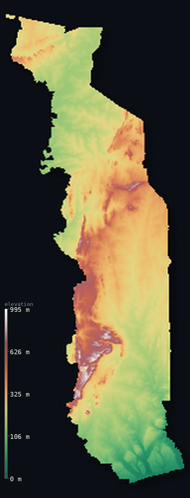
Togo’s highest point is Mont Agou at 3,235 ft (986 m); its lowest is Atlantic Ocean (Gulf of Guinea) at 0 ft (0 m); the mean elevation is 850 ft (259 m).
Togo is a long, narrow country of West Africa, running far north from a short Gulf of Guinea coast to the savanna. Most of it is low: a coastal plain of lagoons in the far south, then the plateaus and the Togo Mountains of the south-centre — a western outlier of the Atakora chain — and beyond them the undulating savanna plains of the centre and north. The one real high ground is Mont Agou, an isolated peak rising to 3,235 ft (986 m), the highest in the country; no land in Togo quite reaches 1,000 m. It is a low, gently rising land: about half of it lies below about 730 ft, in the coastal plain and the river plains inland.
- Highest point📚
- 3,235 ft986 m
- Togo's highest point is Mont Agou at 3,235 ft (986 m), an isolated monadnock in the Plateaux Region southeast of Kpalimé — the westernmost outlier of the Atakora chain, rising abruptly above much flatter land near the Ghanaian border. It is the only summit in Togo to approach 1,000 m; no land in the country quite reaches that height.
- Lowest point📚
- 0 ft0 m
- Togo's lowest point is the Atlantic Ocean at sea level, on its short Gulf of Guinea coast in the far south — a low, sandy shore backed by lagoons, where the capital Lomé sits. From this coast the long, narrow country runs far inland, rising only gently to plateau and savanna.
- Mean elevation⚙
- 850 ft259 m
- Computed from the GLO-30 model, Togo's mean elevation is 850 ft (259 m) — low, for Togo is a long, narrow strip of plateau and savanna with only modest high ground. The Togo Mountains lift the average a little, but about half the country lies below about 732 ft (223 m), in the coastal plain and the broad river plains of the centre and north.
- Median elevation⚙
- 732 ft223 m
- Half of Togo lies below about 732 ft (223 m) — a low figure, because most of the country is low plateau and savanna, rising only gently from the Gulf of Guinea coast. The one real range, the Togo Mountains crossing the south-centre, is a narrow band; the coastal and northern plains hold much of the land.
- Elevation range📚
- 3,235 ft986 m
- From the Gulf of Guinea coast to the summit of Mont Agou at 986 m, Togo's terrain spans about 3,235 ft — a modest range for so long a country, because Togo is mostly low: a narrow strip of plateau and savanna, the Togo Mountains its only real relief, and no land reaching 1,000 m.
- Official area📚
- 21,925 mi²56,785 km²
- Togo covers about 21,925 sq mi (56,785 sq km) — a long, narrow West African country running north from a short Gulf of Guinea coast, of coastal plain, the Togo Mountains (a western outlier of the Atakora chain, holding Mont Agou), and the savanna plains of the centre and north.
- Forest cover📚
- 3.5%
- About 4% of Togo is closed forest — a heavily cleared, farmed land of savanna and plateau, with woodland surviving mainly on the wetter slopes of the Togo Mountains in the south-centre.
Highest and lowest points
The highest point of Togo, Mont Agou (formerly Baumann Peak), 986 m, an isolated monadnock southeast of Kpalime in the Plateaux Region - an extreme western outlier of the Atakora Mountains. It lies close to the Ghanaian border, which can be seen from the summit, but the peak itself is inland. A recent differential-GPS survey suggests nearby Mont Atilakoutse (991 m) may be marginally higher, but Mont Agou remains the recognised summit.
source ↗Togo's lowest point is the Atlantic Ocean at sea level, on its short coast on the Gulf of Guinea — a low, sandy shore backed by a string of coastal lagoons, where the capital Lomé sits. Behind the coast the country stretches far to the north as a long, narrow strip: the coastal plain, then the plateaus and the Togo Mountains of the south-centre, then the undulating savanna plains of the centre and north, drained by the Mono River and, further north, the broad Oti valley toward the Volta system in Ghana. Togo is low throughout but for the Togo Mountains, rising only gently from the sea to the interior.
source ↗Togo at a glance
Togo's highest point, Mont Agou, is only 986 m - no land in the country reaches 1,000 m.
source ↗Mont Agou is a monadnock, an isolated peak rising abruptly from much flatter surrounding land.
source ↗The Togo Mountains continue into Ghana as the Akwapim Hills and into Benin as the Atakora Mountains.
source ↗The country is long and narrow, stretching from a short Gulf of Guinea coast far inland to the savanna.
source ↗Under German rule Mont Agou was named Baumann Peak, after the geographer Oscar Baumann.
source ↗
Elevation profile of Togo
The largest share of land, 34%, falls in the 100–200 m band, and 91% of the territory lies below 500 m (1,640 ft).
- below 500 m (1,640 ft)91%
- 500–1,000 m9%
Highest peaks of Togo
| Peak | Elevation | Range | Note |
|---|---|---|---|
| Mont Agou↗ | 3,235 ft986 m | Togo Mountains (Atakora outlier) | Highest point of Togo, an isolated peak in the southwest; the Togo Mountains as a whole average only about 700 m. |
Togo: the coastal plain, the Togo Mountains, and the northern savanna
The coastal plain
In the far south, a low, sandy Gulf of Guinea coast of lagoons, holding the capital Lomé — Togo's short, warm seaward edge.
The plateaus and Togo Mountains
The southern and central uplands — the Togo Mountains, a southwest-to-northeast outlier of the Atakora chain holding Mont Agou, and the coffee-and-cocoa plateaus around them. The country's only real high ground.
The central and northern savanna
The undulating savanna plains of the centre and north, drained by the Mono River in the south-centre and the broad Oti valley toward the Volta system in Ghana. The low, open bulk of the country.
How to read this map
Color shows elevation; the raised relief shows real terrain. On this map Togo reads as a long, low strip — the low green of the coastal plain in the south and the savanna plains of the centre and north, with the browns of the Togo Mountains (highest at Mont Agou) crossing the south-centre as the one real rise.
Because the country is largely low, the 3D exaggeration is what makes the Togo Mountains stand out; the ×N relief slider controls how much. Tap anywhere to read that point's exact elevation.
City elevations in Togo
Togo's towns run in a line up the long, narrow country — Lomé, the capital, on the Gulf of Guinea coast in the far south, with Sokodé and Kara in the centre and north and Kpalimé in the western hills below Mont Agou. Most lie low, on the plateau and savanna between the coast and the northern plains.
| City | Population | Elevation |
|---|---|---|
| Lomécapitalthe capital, on the Gulf of Guinea coast in the far south ↗ | 2,188,376 | 26 ft8 m |
| Sokodéin the central savanna ↗ | 117,811 | 1,319 ft402 m |
| Karain the north, near the Kara River ↗ | 104,207 | 958 ft292 m |
| Atakpaméin the plateau country of the south-centre ↗ | 80,683 | 1,204 ft367 m |
| Kpaliméin the western hills below Mont Agou ↗ | 75,084 | 738 ft225 m |
| Bassar | 61,845 | 1,362 ft415 m |
| Dapaongin the far north ↗ | 58,071 | 1,056 ft322 m |
| Anéhoon the coast east of Lomé ↗ | 47,579 | 20 ft6 m |
| Mango | 37,748 | 476 ft145 m |
| Notsé | 35,039 | 482 ft147 m |
Elevation sampled at each city centre from the Copernicus GLO-30 model. Cities and population from GeoNames (CC-BY 4.0).
Togo in comparison
Togo's terrain rises 3,235 ft (986 m) from sea level to Mont Agou — about 11% of the height of Mount Everest, the world's highest point at 29,032 ft (8,849 m).
- Ghana's mean elevation is 591 ft — 259 ft lower; its high point, Leklata, reaches 2,953 ft (900 m), 282 ft below. Ghana elevation map →
- Benin's mean elevation is 873 ft — 23 ft higher; its high point, Mont Sokbaro, reaches 2,159 ft (658 m), 1,076 ft below. Benin elevation map →
- Burkina Faso's mean elevation is 978 ft — 128 ft higher; its high point, Mount Tenakourou, reaches 2,457 ft (749 m), 778 ft below. Burkina Faso elevation map →
Frequently asked questions
What is the highest point in Togo?
- Mont Agou, 3,235 ft (986 m), an isolated monadnock in the southwestern Plateaux Region near Kpalimé - the western outlier of the Atakora chain.
What is the lowest point in Togo?
- The Atlantic Ocean at sea level, on its short Gulf of Guinea coast in the far south, where the capital Lomé sits.
What is the average elevation of Togo?
- No standard source publishes one, so this page reports the mean computed from the Copernicus GLO-30 model, 850 ft (259 m) - low, as most of Togo is plateau and savanna; about half the country lies below about 732 ft (223 m).
Does any part of Togo rise above 1,000 m?
- No - the highest point, Mont Agou, is 986 m, so no land in Togo quite reaches 1,000 m.
What are the Togo Mountains?
- A modest range that crosses the south-centre of the country - the western outlier of the Atakora chain, holding Mont Agou and continuing into Ghana as the Akwapim Hills and into Benin as the Atakora.
Is this a topographic, relief, contour, or elevation map of Togo?
- They describe the same thing - terrain height. This page renders Togo's actual elevation surface in interactive 3D and reports the statistics computed from it.
About this map
The terrain is rendered from the Copernicus GLO-30 digital elevation model (ESA), masked to the TGO-ADM0 boundary from geoBoundaries (gbOpen). Elevation statistics are computed directly from the model; peak names and researched facts are sourced and cited. See the methodology for the full pipeline.
Our area-weighted mean, computed from the Copernicus GLO-30 model, is 850 ft (259 m); no authority publishes a mean elevation (No authoritative published mean elevation). Togo is a long, narrow country of low plateau and savanna, with little real high ground. Its one range, the Togo Mountains — a western outlier of the Atakora chain — crosses the south-centre and rises to Mont Agou, but no land in Togo reaches 1,000 m. From the short Gulf of Guinea coast the land climbs only gently inland, so half the country lies below about 732 ft (223 m), in the coastal plain and the broad river plains of the centre and north. No standard source publishes a mean elevation for Togo; the figure here is computed directly from the GLO-30 surface.
Surveyed national figures: official area · forest cover · high point.
Rendered from Copernicus GLO-30 (ESA, 2021 release), boundaries from geoBoundaries. Generated 2026-07-07.
Bordering countries · 3
Togo shares a land border with these countries — open any one to compare its terrain and highest point.