Burkina Faso Elevation Map — Topographic & 3D Terrain
Explore the terrain of Burkina Faso in interactive 3D, built from Copernicus GLO-30 satellite elevation data — a small, flat, landlocked Sahelian country of low plateau and plains. Drag to rotate, scroll to zoom, and tap any point to read its elevation.
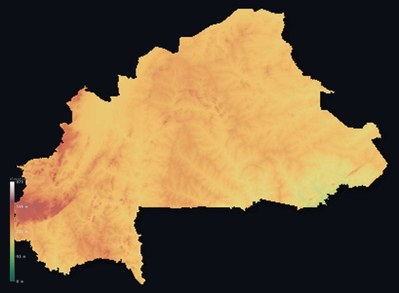
Burkina Faso’s highest point is Mount Tenakourou at 2,457 ft (749 m); its lowest is Mouhoun (Black Volta) River at 656 ft (200 m); the mean elevation is 978 ft (298 m).
Burkina Faso is a flat, landlocked country in the heart of West Africa. Almost all of it is a low, gently undulating plateau — level savanna plains lying mostly between about 650 and 1,150 ft, with elevation changing very little across the whole country. There are no mountains and no coast: the land is a broad, even tableland, drier and more Sahelian toward the north, a little greener in the south. The modest high ground lies in the southwest, where a sandstone plateau rises in low cliffs to the country's highest point, Ténakourou, at 2,457 ft (749 m). Three branches of the Volta River — the Black, White, and Red Volta — drain the country southward.
- Highest point📚
- 2,457 ft749 m
- Burkina Faso's highest point is Ténakourou at 2,457 ft (749 m), on the sandstone plateau of the southwest near the Mali border — a modest height, the high edge of the low cliffs and tablelands that give this corner of the country its only real relief. In a land that is otherwise a flat plateau, it is the closest thing to a summit.
- Lowest point📚
- 656 ft200 m
- Burkina Faso's lowest point is where the Mouhoun (Black Volta) River leaves the country in the south at about 656 ft (200 m) — the low end of a flat country whose gentle slope carries its rivers southward toward Ghana and the sea.
- Mean elevation⚙
- 978 ft298 m
- Computed from the GLO-30 model, Burkina Faso's mean elevation is 978 ft (298 m) — and it is a telling figure, because nearly the whole country lies close to it: Burkina Faso is a remarkably flat, even plateau, with very little of it far above or below the average, and no true high or low ground to speak of.
- Median elevation⚙
- 965 ft294 m
- Half of Burkina Faso lies below about 965 ft (294 m) — and because the country is so flat, the median sits very close to the mean: most of the land is a low, even plateau at much the same modest height, with only the southwestern cliffs rising a little above.
- Elevation range📚
- 1,801 ft549 m
- Burkina Faso's whole vertical span is only about 1,800 ft — the Mouhoun's exit at 200 m to Ténakourou at 749 m in the far southwest. It is one of the gentlest ranges of any country: Burkina is a flat plateau throughout, with no mountains and only the low southwestern cliffs for relief.
- Official area📚
- 105,869 mi²274,200 km²
- Burkina Faso covers about 105,900 sq mi (274,200 sq km) — a small, landlocked West African country in the Sahel, a flat, low plateau of savanna plains, drained southward by the three branches of the Volta River, with modest cliffs in the southwest.
- Forest cover📚
- 19.3%
- About 19% of Burkina Faso is forested — not much: most of the country is savanna grassland and farmland, drier and more sparsely wooded toward the Sahelian north, with denser wooded savanna in the south and southwest.
Highest and lowest points
Burkina Faso's highest point is Ténakourou, 2,457 ft (749 m), on the sandstone plateau of the far southwest, near the border with Mali. This corner of the country — around Banfora — holds its only real relief: a low sandstone plateau breaking into modest cliffs and escarpments (the Banfora Cliffs, the Sindou Peaks), greener and more broken than the flat plains that make up the rest of Burkina Faso. Ténakourou is the high edge of this plateau. It is no mountain — the country is a flat tableland throughout, without a single true summit — but in a land this level, this southwestern rise is the nearest thing to high ground.
source ↗Burkina Faso's lowest point is where the Mouhoun, or Black Volta, River leaves the country in the south, at about 656 ft (200 m) above sea level. The whole country slopes very gently — from the slightly higher plateau of the centre and southwest down toward the south — and this slope carries its rivers, the three Voltas (the Mouhoun/Black, the Nakambé/White, and the Nazinon/Red Volta), southward across the border into Ghana and on toward the Gulf of Guinea. Landlocked and flat, Burkina Faso has no dramatic low ground: the difference between its highest and lowest points is slight, spread across a broad, even land.
source ↗Burkina Faso at a glance
Burkina Faso is remarkably flat — most of it is a savanna plateau between about 200 and 400 m, and its highest point, Mount Tenakourou, is only 749 m.
source ↗Because it is landlocked and sits on a plateau, Burkina Faso's lowest point is not the sea but the Black Volta River, at about 200 m above sea level.
source ↗The summit of Mount Tenakourou overlooks three countries at once — Burkina Faso, Mali (3 km away) and Côte d'Ivoire (13 km away).
source ↗In 1974 the French piled up stones on Tenakourou's summit to raise its official height to a round 750 m.
source ↗The country's name means 'Land of Incorruptible People' — adopted in 1984, replacing the colonial name Upper Volta, after the three Volta rivers that drain it.
source ↗To fight drought and erosion on the flat Sahel, Burkinabè farmers build 'diguettes' — low lines of stones along field edges that trap rainwater and slow soil loss.
source ↗The eroded Sindou Peaks in the southwest — a serrated ridge of sandstone cones — are one of the country's most striking natural landmarks on an otherwise level landscape.
source ↗
Elevation profile of Burkina Faso
The largest share of land, 47%, falls in the 250–300 m band, and 99% of the territory lies below 500 m (1,640 ft).
- below 500 m (1,640 ft)99%
- 500–1,000 m1%
Highest peaks of Burkina Faso
| Peak | Elevation | Range | Note |
|---|---|---|---|
| Mount Tenakourou↗ | 2,457 ft749 m | southwestern sandstone massif | Highest point of Burkina Faso, on the Mali border; its summit overlooks Burkina Faso, Mali and Côte d'Ivoire. |
| Sindou Peaks (high point)↗ | 1,969 ft600 m | southwestern sandstone massif | A serrated ridge of eroded sandstone cones near Sindou in the southwest, famous for their dramatic shapes. |
| Banfora Escarpment (Cascades)↗ | 1,640 ft500 m | southwestern sandstone massif | The sandstone escarpment around Banfora in the Cascades Region, with the Karfiguéla waterfalls. |
| Gobnangou Hills↗ | 1,312 ft400 m | southeastern hills | A low escarpment range in the far southeast, one of the few relief features outside the western massif. |
| Mossi plateau high ground↗ | 1,148 ft350 m | central plateau | The broad savanna tableland of the central Mossi Highlands, 200–400 m, that covers most of the country. |
Burkina Faso: the central plateau, the Sahelian north, and the southwestern cliffs
The central plateau
Most of Burkina Faso is a low, gently undulating plateau — level savanna plains at a modest, even height, holding the capital, Ouagadougou, and most of the population. Flat, open, and farmed, it is the broad tableland that is the country's essential form.
The Sahelian north
Northern Burkina Faso is Sahel — drier, more sparsely grassed plains shading toward the desert margin, flat and open like the rest of the country but browner and more thinly settled. The dry northern edge.
The southwestern plateau and cliffs
The far southwest, around Banfora, holds the country's only real relief — a higher sandstone plateau breaking into low cliffs and escarpments (the Banfora Cliffs, the Sindou Peaks) and rising to Ténakourou, the high point. Greener, more broken, and more scenic than the flat plains elsewhere.
How to read this map
Color shows elevation; the raised relief shows real terrain. On this map Burkina Faso reads as a flat, even country — a broad expanse of low, uniform tone covering almost all of it, the level savanna plateau, with only the faintest rise in the southwest (the Banfora sandstone plateau around Ténakourou) showing as slightly higher ground.
With so little relief, the 3D exaggeration is what makes the gentle differences visible at all; the ×N relief slider controls how much. Tap anywhere to read that point's exact elevation.
City elevations in Burkina Faso
Burkina Faso's cities sit on the plateau — Ouagadougou, the capital, in the centre, Bobo-Dioulasso in the southwest (the second city), Koudougou nearby, and others spread across the level country. Nearly all lie at much the same modest height.
| City | Population | Elevation |
|---|---|---|
| Ouagadougoucapitalthe capital, on the central plateau ↗ | 2,415,266 | 971 ft296 m |
| Bobo-Dioulassothe second city, in the southwest ↗ | 904,920 | 1,355 ft413 m |
| Koudougouin the centre-west ↗ | 160,239 | 974 ft297 m |
| Ouahigouyain the northwest, toward the Sahel ↗ | 124,587 | 1,083 ft330 m |
| Kayain the north-centre ↗ | 121,970 | 1,099 ft335 m |
| Banforain the southwest, by the sandstone cliffs ↗ | 117,452 | 1,047 ft319 m |
| Pouytengain the centre-east ↗ | 96,469 | 1,030 ft314 m |
| Houndéin the southwest ↗ | 87,151 | 1,145 ft349 m |
| Fada N'gourmain the east ↗ | 73,200 | 968 ft295 m |
| Dédougouin the west ↗ | 63,617 | 978 ft298 m |
Elevation sampled at each city centre from the Copernicus GLO-30 model. Cities and population from GeoNames (CC-BY 4.0).
Burkina Faso in comparison
Burkina Faso's terrain rises 1,801 ft (549 m) from Mouhoun (Black Volta) River (656 ft (200 m)) to Mount Tenakourou — about 6% of the height of Mount Everest, the world's highest point at 29,032 ft (8,849 m).
- Mali's mean elevation is 1,043 ft — 66 ft higher; its high point, Hombori Tondo, reaches 3,789 ft (1,155 m), 1,332 ft above. Mali elevation map →
- Ghana's mean elevation is 591 ft — 387 ft lower; its high point, Leklata, reaches 2,953 ft (900 m), 495 ft above. Ghana elevation map →
- Niger's mean elevation is 1,503 ft — 525 ft higher; its high point, Mont Idoukal-n-Taghes, reaches 6,634 ft (2,022 m), 4,177 ft above. Niger elevation map →
- Côte d'Ivoire's mean elevation is 853 ft — 125 ft lower; its high point, Mont Nimba (Mount Richard-Molard), reaches 5,748 ft (1,752 m), 3,291 ft above. Côte d'Ivoire elevation map →
Frequently asked questions
What is the highest point in Burkina Faso?
- Ténakourou, 2,457 ft (749 m), on a sandstone plateau in the far southwest near Mali — a modest rise, as the country has no true mountains.
What is the lowest point in Burkina Faso?
- Where the Mouhoun (Black Volta) River leaves the country in the south, at about 656 ft (200 m) — the land slopes gently southward toward Ghana.
What is the average elevation of Burkina Faso?
- Computed from the Copernicus GLO-30 model, the area-weighted mean is 978 ft (298 m) — and the country is so flat that most of it lies close to this height, with no true high or low ground.
Is Burkina Faso flat?
- Yes — almost the whole country is a low, even plateau of savanna plains, with no mountains. The only real relief is the southwestern sandstone plateau around Ténakourou (749 m) and the Banfora Cliffs.
What rivers flow through Burkina Faso?
- The three branches of the Volta — the Black (Mouhoun), White (Nakambé), and Red (Nazinon) — which drain the country southward toward Ghana and the Gulf of Guinea.
Is this a topographic, relief, contour, or elevation map of Burkina Faso?
- They describe the same thing — terrain height. This page renders the country's actual elevation surface in interactive 3D and reports the statistics computed from it.
About this map
The terrain is rendered from the Copernicus GLO-30 digital elevation model (ESA), masked to the BFA-ADM0 boundary from geoBoundaries (gbOpen). Elevation statistics are computed directly from the model; peak names and researched facts are sourced and cited. See the methodology for the full pipeline.
Our area-weighted mean, computed from the Copernicus GLO-30 model, is 978 ft (298 m); the figure commonly cited elsewhere is 974 ft (297 m) (CIA World Factbook). Burkina Faso is a flat savanna plateau — most of it lies between about 200 and 400 m, with only the southwestern hills rising higher — so the mean elevation is low; the page reports the area-weighted figure computed from the Copernicus GLO-30 model.
Surveyed national figures: official area · forest cover · high point.
Rendered from Copernicus GLO-30 (ESA, 2021 release), boundaries from geoBoundaries. Generated 2026-06-22.
Bordering countries · 6
Burkina Faso shares a land border with these countries — open any one to compare its terrain and highest point.