Mali Elevation Map — Topographic & 3D Terrain
Explore the terrain of Mali in interactive 3D, built from Copernicus GLO-30 satellite elevation data — a vast, mostly flat Sahelian and Saharan country shaped by the great arc of the Niger River. Drag to rotate, scroll to zoom, and tap any point to read its elevation.
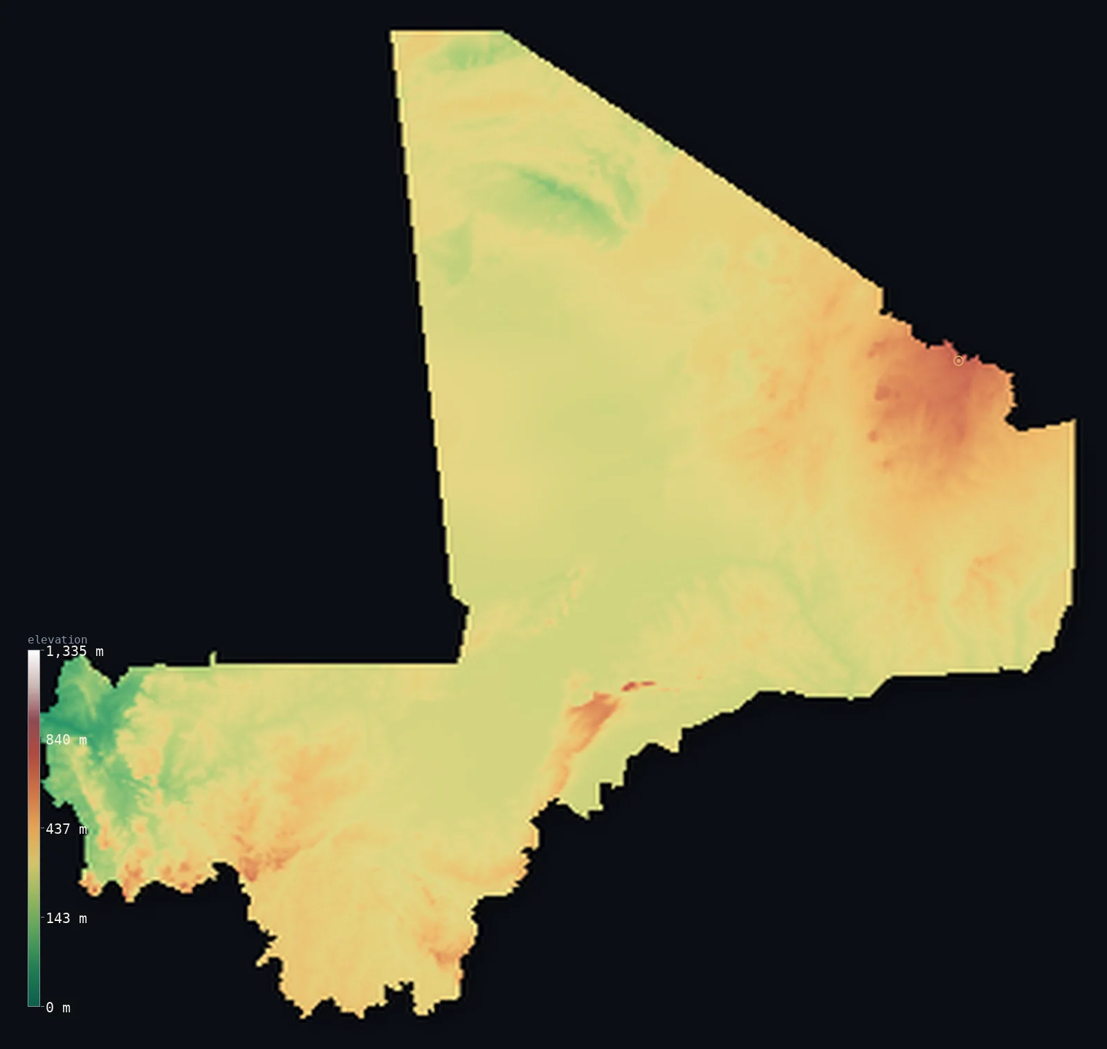
Mali’s highest point is Hombori Tondo at 3,789 ft (1,155 m); its lowest is Senegal River at 75 ft (23 m); the mean elevation is 1,043 ft (318 m).
Mali is a vast, mostly flat country straddling the Sahara and the Sahel. Much of it is low, level plain and plateau — desert across the north, dry grassland savanna in the south — with elevation changing only gently over enormous distances. Its defining feature is the Niger River, which sweeps in a great arc through the country's heart, spreading into a vast inland delta of channels and marshes before curving past Timbuktu and back southeast. The highest ground is modest and lies in the east and the far northeast — the Hombori mountains, rising to Hombori Tondo at 3,789 ft (1,155 m), and the rugged Adrar des Ifoghas on the Algerian border.
- Highest point📚
- 3,789 ft1,155 m
- Mali's highest point is Hombori Tondo at 3,789 ft (1,155 m), a flat-topped sandstone mesa in the Hombori mountains of eastern Mali — the highest of the isolated tablelands that rise abruptly from the surrounding plains. In a country that is mostly low and level, it stands out sharply, a rocky island above the Sahel.
- Lowest point📚
- 75 ft23 m
- Mali's lowest point is on the Senegal River in the far west at about 75 ft (23 m) — the low end of a country whose land, though mostly flat, tilts gently down toward its western and northern rivers and basins.
- Mean elevation⚙
- 1,043 ft318 m
- Computed from the GLO-30 model, Mali's mean elevation is 1,043 ft (318 m) — low, and stretched thin across a vast country: Saharan sand and gravel in the north, Sahelian grassland in the south, the whole of it a level plain that changes height only gently over hundreds of miles, broken only by the isolated massifs of the east.
- Median elevation⚙
- 991 ft302 m
- Half of Mali lies below about 991 ft (302 m), and the country barely departs from it — a level expanse of desert and Sahel where elevation shifts only gradually across enormous distances, with the eastern mesas and the far-northeastern Adrar the rare exceptions.
- Elevation range📚
- 3,714 ft1,132 m
- Across a country this vast, Mali's terrain spans only about 3,710 ft — from the Senegal River at 23 m in the far west to Hombori Tondo's 1,155 m mesa in the east. Over most of the enormous distance between, the land barely rises or falls at all: Mali is a flat plain, desert and Sahel, its few mesas the only real relief.
- Above 1,000 m (3,281 ft)⚙
- <1%
- Less than 1% of Mali rises above 1,000 m (3,281 ft) — essentially only the summit of Hombori Tondo and the eastern massifs; even 500 m is cleared by just 4% of the country. Nearly all of Mali is low desert and Sahel plateau, most of it between about 200 and 500 m.
- Official area📚
- 478,841 mi²1,240,192 km²
- Mali covers about 478,800 sq mi (1,240,192 sq km) — a vast, landlocked West African country straddling the Sahara and the Sahel, mostly flat plain and low plateau, shaped by the great arc of the Niger River, with isolated massifs in the east.
- Forest cover📚
- 3.8%
- About 4% of Mali is forested — very little, as most of the country is Saharan desert or dry Sahelian grassland; what wooded savanna there is lies in the wetter south, toward the Niger and the Guinea border, with the north bare desert.
Highest and lowest points
Mali's highest point is Hombori Tondo, 3,789 ft (1,155 m), a dramatic flat-topped sandstone mesa in the Hombori mountains of eastern Mali. It is the highest of a cluster of isolated tablelands and towers that rise abruptly from the flat Sahel — sheer-sided rock islands, including the famous Main de Fatma spires nearby, standing hundreds of metres above the surrounding plains. In a country that is otherwise mostly low and level, Hombori Tondo is a striking landmark. Farther northeast, on the Algerian border, the rugged Adrar des Ifoghas forms another patch of higher, broken ground — a low massif of rock and sand — but Hombori Tondo is the country's summit, an island of height above the Sahel.
source ↗Mali's lowest point is on the Senegal River in the far west, at about 75 ft (23 m) above sea level — where the river, gathered from the wet highlands of Guinea, flows northwest out of Mali toward the Atlantic. But the river that defines Mali is the Niger, which enters from the southwest, sweeps northeast in a great arc through the country's heart — spreading into the vast Inland Niger Delta, a maze of channels, lakes, and seasonal marshes — then curves past Timbuktu at the desert's edge before bending southeast toward Niger. This great looping river, and the delta at its centre, are the lifeline of a mostly dry and level land.
source ↗Mali at a glance
Mali's high point, Hombori Tondo (1,155 m), is a flat-topped mesa whose ~2 km2 summit is so cut off by cliffs that it shelters far more plant species than the surrounding plains.
source ↗Despite being about two-thirds desert, Mali is crossed by the Niger River, whose Inner Delta floods up to 30,000 km2 each year - a green lifeline in the Sahel.
source ↗The Bandiagara Escarpment in central-eastern Mali is famous for the cliff-built villages of the Dogon people.
source ↗Near Hombori stand the Hand of Fatima rock spires and the Needles of Garmi, among the most striking rock-climbing landmarks in West Africa.
source ↗Mali is one of the hottest countries on Earth - the thermal equator, the band of highest year-round average temperatures, crosses it.
source ↗Mali borders seven countries along more than 7,200 km of frontier, yet is entirely landlocked.
source ↗
Elevation profile of Mali
The largest share of land, 45%, falls in the 200–300 m band, and 96% of the territory lies below 500 m (1,640 ft).
- below 500 m (1,640 ft)96%
- 500–1,000 m4%
- 1,000–2,000 m<1%
Highest peaks of Mali
| Peak | Elevation | Range | Note |
|---|---|---|---|
| Hombori Tondo↗ | 3,789 ft1,155 m | Hombori Mountains (central-east) | Highest point of Mali, a flat-topped sandstone mesa rising from the Sahel near the town of Hombori. |
| Adrar des Ifoghas (high ground)↗ | 2,920 ft890 m | Adrar des Ifoghas (northeast) | A rugged eroded sandstone massif in the far northeast near Algeria, the main relief of the desert north, exceeding 900 m in places. |
| Mandingue Plateau (high ground)↗ | 2,100 ft640 m | Mandingue Plateau (southwest) | The sandstone plateau around Bamako in the southwest, rising to roughly 600-640 m. |
Mali: the Saharan north, the Sahel and the Niger, and the eastern massifs
The Saharan north
Northern Mali is Sahara — vast, low, level desert of sand seas, gravel plains, and bare rock, reaching up to the Algerian border and the rugged Adrar des Ifoghas. Enormous, dry, and thinly peopled, it is well over half the country.
The Sahel and the Niger (the centre and south)
Central and southern Mali is Sahel — dry grassland and savanna plains, wetter toward the south, and threaded by the great arc of the Niger River and its vast inland delta. Low and level but for the river's floodplains, this is where nearly all Malians live.
The eastern massifs
Eastern Mali holds the country's high ground — the Hombori mountains, with Hombori Tondo (the high point) and the Dogon country's Bandiagara Escarpment, a long sandstone cliff. Isolated tablelands and cliffs rising abruptly from the plains, the country's only real relief.
How to read this map
Color shows elevation; the raised relief shows real terrain. On this map Mali reads as a vast, mostly level country — broad low plains filling nearly all of it, in the muted tones of desert and Sahel, with the great arc of the Niger River and its inland delta threading the centre, and only the isolated eastern massifs (Hombori Tondo, the Bandiagara Escarpment) and the far-northeastern Adrar rising into higher browns.
The 3D relief is the actual GLO-30 elevation data, exaggerated vertically so the gentle differences and the isolated massifs show; the ×N relief slider controls how much. Tap anywhere to read that point's exact elevation.
City elevations in Mali
Mali's cities cluster along the Niger and in the south — Bamako, the capital, on the Niger in the southwest, Ségou and Mopti downstream on the river, Sikasso in the far south, and Timbuktu and Gao on the Niger at the desert's edge. Nearly all lie on the river or in the wetter south.
| City | Population | Elevation |
|---|---|---|
| Bamakocapitalthe capital, on the Niger River in the southwest ↗ | 4,227,569 | 1,066 ft325 m |
| Sikassoin the far south, toward the Côte d'Ivoire border ↗ | 349,324 | 1,194 ft364 m |
| Koutialain the southern savanna ↗ | 218,031 | 1,158 ft353 m |
| Ségouon the Niger, downstream of Bamako ↗ | 205,787 | 955 ft291 m |
| Kayesin the far west, on the Senegal River ↗ | 194,716 | 105 ft32 m |
| Moption the Niger, at the inland delta ↗ | 186,187 | 879 ft268 m |
| Gaoon the Niger in the east, at the desert's edge ↗ | 133,110 | 837 ft255 m |
| Bougouniin the southern savanna ↗ | 90,234 | 1,135 ft346 m |
| Timbuktuon the Niger at the southern edge of the Sahara ↗ | 84,208 | 896 ft273 m |
| Kitain the west, southwest of Kayes ↗ | 75,598 | 1,089 ft332 m |
Elevation sampled at each city centre from the Copernicus GLO-30 model. Cities and population from GeoNames (CC-BY 4.0).
Mali in comparison
Mali's terrain rises 3,714 ft (1,132 m) from Senegal River (75 ft (23 m)) to Hombori Tondo — about 13% of the height of Mount Everest, the world's highest point at 29,032 ft (8,849 m).
- Burkina Faso's mean elevation is 978 ft — 66 ft lower; its high point, Mount Tenakourou, reaches 2,457 ft (749 m), 1,332 ft below. Burkina Faso elevation map →
- Niger's mean elevation is 1,503 ft — 459 ft higher; its high point, Mont Idoukal-n-Taghes, reaches 6,634 ft (2,022 m), 2,844 ft above. Niger elevation map →
- Mauritania's mean elevation is 853 ft — 190 ft lower; its high point, Kediet ej Jill, reaches 3,002 ft (915 m), 787 ft below. Mauritania elevation map →
- Guinea's mean elevation is 1,447 ft — 404 ft higher; its high point, Mount Nimba (Mont Richard-Molard), reaches 5,748 ft (1,752 m), 1,959 ft above. Guinea elevation map →
Frequently asked questions
What is the highest point in Mali?
- Hombori Tondo, 3,789 ft (1,155 m), a flat-topped sandstone mesa in the Hombori mountains of eastern Mali — the highest of the isolated tablelands rising from the Sahel.
What is the lowest point in Mali?
- On the Senegal River in the far west, at about 75 ft (23 m), where the river flows out toward the Atlantic.
What is the average elevation of Mali?
- Computed from the Copernicus GLO-30 model, the area-weighted mean is 1,043 ft (318 m) — low, because Mali is mostly flat desert and Sahel plains, with only isolated eastern massifs rising high.
Is Mali flat?
- Mostly — vast level plains of desert and Sahel cover nearly all the country, changing height only gently. The main relief is in the east: the Hombori mountains (with Hombori Tondo, 1,155 m) and the Bandiagara Escarpment.
What is the Inland Niger Delta?
- A vast wetland in central Mali where the Niger River spreads into a maze of channels, lakes, and seasonal marshes — one of the largest inland deltas in the world, in the middle of a dry land.
Is this a topographic, relief, contour, or elevation map of Mali?
- They describe the same thing — terrain height. This page renders the country's actual elevation surface in interactive 3D and reports the statistics computed from it.
About this map
The terrain is rendered from the Copernicus GLO-30 digital elevation model (ESA), masked to the MLI-ADM0 boundary from geoBoundaries (gbOpen). Elevation statistics are computed directly from the model; peak names and researched facts are sourced and cited. See the methodology for the full pipeline.
Our area-weighted mean, computed from the Copernicus GLO-30 model, is 1,043 ft (318 m); the figure commonly cited elsewhere is 1,125 ft (343 m) (CIA World Factbook). Mali is mostly flat to rolling plains and low plateaus (200-500 m), about two-thirds desert, with rugged uplands only in the northeast and a few central mesas, so its mean elevation is modest; the page reports the area-weighted figure computed from the Copernicus GLO-30 model.
Surveyed national figures: official area · forest cover · high point.
Rendered from Copernicus GLO-30 (ESA, 2021 release), boundaries from geoBoundaries. Generated 2026-06-24.
Bordering countries · 7
Mali shares a land border with these countries — open any one to compare its terrain and highest point.