Algeria Elevation Map — Topographic & 3D Terrain
Explore the terrain of Algeria in interactive 3D, built from Copernicus GLO-30 satellite elevation data — Africa's largest country, almost all of it Sahara. Drag to rotate, scroll to zoom, and tap any point to read its elevation.
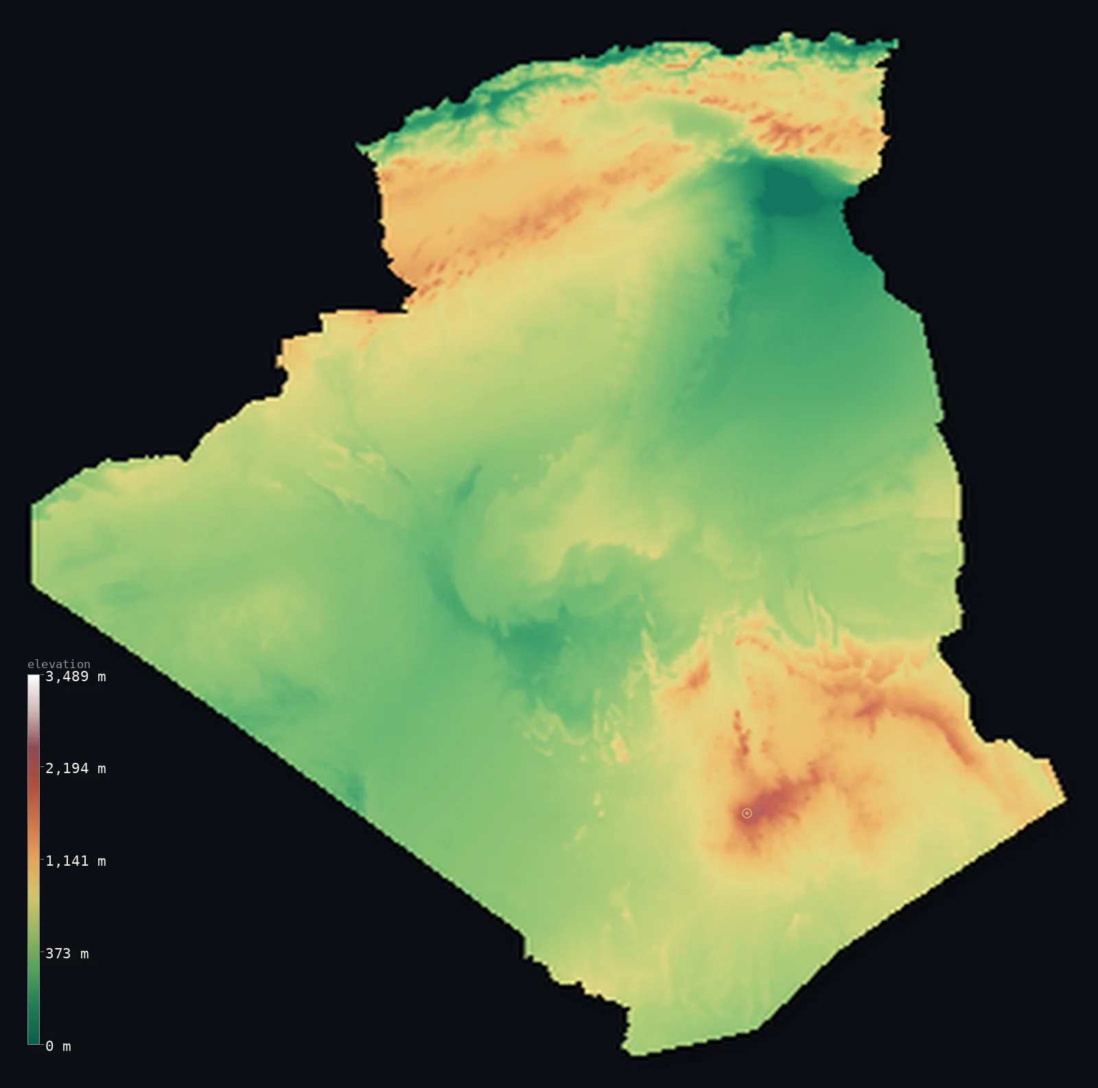
Algeria’s highest point is Mount Tahat at 9,541 ft (2,908 m); its lowest is Chott Melrhir at −131 ft (−40 m); the mean elevation is 1,827 ft (557 m).
Algeria is upside down. Nearly everyone lives in the narrow green strip along the Mediterranean, but the country's highest ground is 1,500 km away in the opposite direction — Mount Tahat, 9,541 ft (2,908 m), a volcanic peak in the Hoggar massif deep in the Sahara. Between the two lies the largest country in Africa, more than four-fifths of it desert, dipping below sea level at the Chott Melrhir salt lake.
- Highest point📚
- 9,541 ft2,908 m
- Algeria's highest point is Mount Tahat at 9,541 ft (2,908 m), in the Hoggar massif of the far south — a weathered volcanic peak rising from the middle of the Sahara, about as far from the country's populated coast as it is possible to be.
- Lowest point📚
- −131 ft−40 m
- Algeria's lowest point is Chott Melrhir at 131 ft (40 m) below sea level — a shallow salt lake in the northeast that fills briefly after rain and spends most of the year as a glittering crust.
- Mean elevation⚙
- 1,827 ft557 m
- Algeria's mean elevation computed from the GLO-30 model is 1,827 ft (557 m) — a middling figure for a country of this size, produced by an enormous expanse of Saharan plateau sitting a few hundred metres up, with the Atlas ranges in the north and the Hoggar in the south at either end.
- Median elevation⚙
- 1,568 ft478 m
- Half of Algeria lies below 1,568 ft (478 m) — under the mean, because the high ground is concentrated in two distant massifs while the vast desert plateaus and sand seas in between sit lower and cover far more area.
- Elevation range📚
- 9,672 ft2,948 m
- From Chott Melrhir below sea level to the summit of Mount Tahat, Algeria spans about 9,670 ft — with its two extremes about 1,000 km apart, one in the northeastern lowlands and one in the deep southern desert.
- Above 1,000 m (3,281 ft)⚙
- 12%
- About 12% of Algeria rises above 1,000 m (3,281 ft) — split between the Atlas ranges of the north, which wall the coast off from the desert, and the Hoggar and Tassili massifs of the far south.
- Official area📚
- 919,595 mi²2,381,740 km²
- Algeria covers about 920,000 sq mi (2,381,740 sq km) — the largest country in Africa, and more than four-fifths of it Sahara.
- Forest cover📚
- 0.8%
- About 0.8% of Algeria is forested — cork oak, pine, and cedar on the wetter northern slopes of the Tell Atlas, and essentially nothing at all south of the Saharan Atlas.
Highest and lowest points
Algeria's highest point is Mount Tahat, 9,541 ft (2,908 m), in the Hoggar massif of the Ahaggar in the deep south — an eroded volcanic peak in one of the most remote landscapes on Earth. The Hoggar is a highland island in the Sahara: high enough to be measurably cooler and wetter than the desert around it, with rock art thousands of years old recording a time when the region was green. It lies roughly 1,500 km from Algiers, so the country's summit is about as far from its population as geography allows.
source ↗Algeria's lowest point is Chott Melrhir, 131 ft (40 m) below sea level in the northeast near the Tunisian border. It is a chott — a shallow endorheic salt lake with no outlet, which fills with a few centimetres of water after winter rain and then evaporates through the summer, leaving a white crust that can be crossed on foot. It sits in a belt of similar depressions along the northern edge of the Sahara, where the land dips below the Mediterranean without ever reaching it.
source ↗Algeria at a glance
Algeria's highest point, Mount Tahat (2,908 m), stands in the Hoggar massif deep in the Sahara - roughly 1,500 km from the Mediterranean coast where almost all Algerians live.
source ↗Algeria is the largest country in Africa, and more than four-fifths of its territory is desert.
source ↗Chott Melrhir in the northeast lies about 40 m below sea level - a salt lake that fills after rain and dries to a crust.
source ↗The Atlas mountains run in two parallel chains across northern Algeria - the Tell Atlas along the coast and the Saharan Atlas inland - with high plateaus between them.
source ↗Rock art in the Tassili n'Ajjer of the southeast, dating back more than 12,000 years, records a time when the Sahara was green and inhabited.
source ↗The Hoggar highlands are cool and moist enough, relative to the surrounding desert, to support relict plants left over from a wetter climate.
source ↗The Hoggar massif is built on rock around 2 billion years old, later capped by volcanic eruptions that pushed its jagged spires thousands of metres above the surrounding Sahara.
source ↗Sand seas cover about a quarter of the Algerian Sahara - in the Grand Erg Oriental, dunes 2-5 m high march across the landscape spaced about 40 m apart.
source ↗
Elevation profile of Algeria
The largest share of land, 29%, falls in the 200–400 m band, with the land split almost evenly above and below 500 m (1,640 ft).
- below 500 m (1,640 ft)53%
- 500–1,000 m35%
- 1,000–2,000 m12%
- above 2,000 m (6,562 ft)<1%
Highest peaks of Algeria
| Peak | Elevation | Range | Note |
|---|---|---|---|
| Mount Tahat↗ | 9,541 ft2,908 m | Hoggar (Ahaggar) Mountains | Highest point of Algeria, a volcanic peak in the central Sahara with over 2,300 m of prominence. |
| Assekrem↗ | 9,121 ft2,780 m | Hoggar (Ahaggar) Mountains | A high Hoggar peak whose Tuareg name means 'end of the world'; famous for its sunrise views. |
| Djebel Chelia↗ | 7,638 ft2,328 m | Aurès Mountains | Highest peak of the Aurès range in the northeast — the highest point of northern Algeria. |
| Lalla Khedidja↗ | 7,572 ft2,308 m | Djurdjura (Tell Atlas) | Highest peak of the Djurdjura range in Kabylie, the high point of the Tell Atlas near the coast. |
| Djebel Aissa↗ | 7,336 ft2,236 m | Ksour (Saharan Atlas) | A high peak of the Ksour range in the Saharan Atlas near the Moroccan border. |
| Adrar Afao↗ | 7,080 ft2,158 m | Tassili n'Ajjer | Highest point of the Tassili n'Ajjer plateau, a UNESCO site famed for prehistoric rock art. |
The green north, the Sahara, and the southern massifs
The Tell and the Mediterranean coast
A narrow, green, mountainous strip along the sea — the Tell Atlas rising directly behind the coastal plain, catching what rain the Mediterranean brings. It is a small fraction of Algeria's area and holds almost all of its people, its cities, and its farmland.
The high plateaus and the Saharan Atlas
Behind the Tell lie the Hauts Plateaux, dry steppe basins with salt chotts, and beyond them the Saharan Atlas — a second range that forms the true barrier between the Mediterranean world and the desert. Chott Melrhir, the country's low point, lies at this belt's eastern end.
The Sahara
South of the Atlas, more than four-fifths of Algeria is desert — the great sand seas of the Grand Erg Occidental and Oriental, gravel plains, and rocky plateaus stretching for a thousand kilometres with almost no permanent population.
The Hoggar and Tassili massifs
In the far south the desert floor lifts into volcanic highlands — the Hoggar, carrying Mount Tahat, and the eroded sandstone plateaus of the Tassili n'Ajjer. Cooler and slightly wetter than the sand around them, they are islands of relict life and ancient rock art in the middle of the Sahara.
How to read this map
Color shows elevation; the raised relief shows real terrain. On this map Algeria reads as a thin crumpled green-brown band along the northern coast, then a vast, smooth, pale desert filling the body of the country, with a distinct raised massif appearing in the far south.
The 3D relief is the actual GLO-30 elevation data, exaggerated vertically so both the northern ranges and the isolated Hoggar stand out; the ×N relief slider controls how much. Tap anywhere to read that point's exact elevation.
City elevations in Algeria
Algerian cities are coastal almost without exception - Algiers, Oran, and Constantine all in the northern Tell, within sight or a short drive of the Mediterranean. The desert that makes up most of the country holds only scattered oasis towns.
| City | Population | Elevation |
|---|---|---|
| Algierscapitalthe capital, on the Mediterranean coast backed immediately by the Tell Atlas ↗ | 2,364,230 | 377 ft115 m |
| Oranon the northwestern coast, in the coastal Tell ↗ | 803,329 | 354 ft108 m |
| Constantineinland in the eastern Tell, on a plateau cut by a deep gorge ↗ | 448,028 | 1,946 ft593 m |
| Djelfa | 265,833 | 3,730 ft1,137 m |
| Biskra | 204,661 | 394 ft120 m |
| Tébessa | 194,461 | 2,844 ft867 m |
| El Oued | 186,525 | 276 ft84 m |
| Tiaret | 178,915 | 3,373 ft1,028 m |
| Béjaïa | 176,139 | 262 ft80 m |
| Ouargla | 169,928 | 449 ft137 m |
Elevation sampled at each city centre from the Copernicus GLO-30 model. Cities and population from GeoNames (CC-BY 4.0).
Algeria in comparison
Algeria's terrain rises 9,672 ft (2,948 m) from Chott Melrhir, 131 ft (40 m) below sea level to Mount Tahat — about 33% of the height of Mount Everest, the world's highest point at 29,032 ft (8,849 m).
- Morocco's mean elevation is 2,060 ft — 233 ft higher; its high point, Jbel Toubkal, reaches 13,671 ft (4,167 m), 4,131 ft above. Morocco elevation map →
- Tunisia's mean elevation is 833 ft — 994 ft lower; its high point, Jebel ech Chambi, reaches 5,066 ft (1,544 m), 4,475 ft below. Tunisia elevation map →
- Egypt's mean elevation is 988 ft — 840 ft lower; its high point, Mount Catherine (Gebel Katherina), reaches 8,625 ft (2,629 m), 915 ft below. Egypt elevation map →
Frequently asked questions
What is the highest point in Algeria?
- Mount Tahat, 9,541 ft (2,908 m), a volcanic peak in the Hoggar massif of the deep Sahara - about 1,500 km from the populated Mediterranean coast.
What is the lowest point in Algeria?
- Chott Melrhir in the northeast, about 131 ft (40 m) below sea level - a salt lake that fills after rain and dries to a crust.
What is the average elevation of Algeria?
- Computed from the Copernicus GLO-30 model, the area-weighted mean is 1,827 ft (557 m) - produced mostly by the vast Saharan plateaus rather than by the mountains at either end of the country.
How much of Algeria is desert?
- More than four-fifths. The Sahara covers everything south of the Saharan Atlas, while the population lives in the narrow Mediterranean strip in the north.
Is Algeria the largest country in Africa?
- Yes - at about 2.38 million sq km it is the largest country on the continent.
Is this a topographic, relief, contour, or elevation map of Algeria?
- They describe the same thing - terrain height. This page renders the country's actual elevation surface in interactive 3D and reports the statistics computed from it.
About this map
The terrain is rendered from the Copernicus GLO-30 digital elevation model (ESA), masked to the DZA-ADM0 boundary from geoBoundaries (gbOpen). Elevation statistics are computed directly from the model; peak names and researched facts are sourced and cited. See the methodology for the full pipeline.
Our area-weighted mean, computed from the Copernicus GLO-30 model, is 1,827 ft (557 m); the figure commonly cited elsewhere is 2,625 ft (800 m) (CIA World Factbook). Algeria is the largest country in Africa and over 80% Sahara, but much of that desert is high plateau and the Hoggar massif rather than low sand, so the mean is moderate; the page reports the area-weighted figure computed from the Copernicus GLO-30 model.
Surveyed national figures: official area · forest cover · high point.
Rendered from Copernicus GLO-30 (ESA, 2021 release), boundaries from geoBoundaries. Generated 2026-06-22.
Bordering countries · 6
Algeria shares a land border with these countries — open any one to compare its terrain and highest point.