Morocco Elevation Map — Topographic & 3D Terrain
Explore the terrain of Morocco in interactive 3D, built from Copernicus GLO-30 satellite elevation data — a high country of Atlas ranges walling the fertile north from the Sahara. Drag to rotate, scroll to zoom, and tap any point to read its elevation.
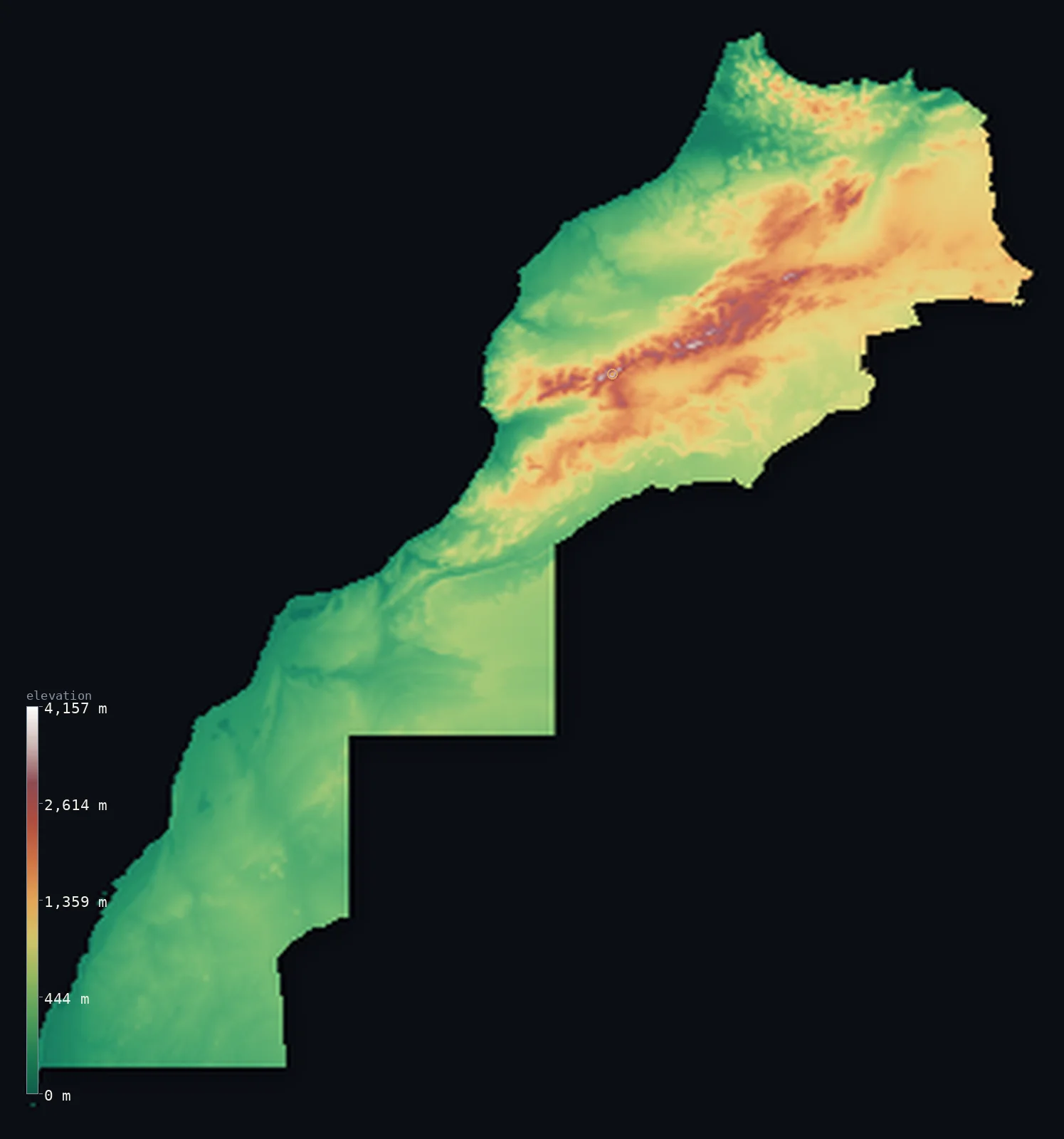
Morocco’s highest point is Jbel Toubkal at 13,671 ft (4,167 m); its lowest is Sebkha Tah at −180 ft (−55 m); the mean elevation is 2,060 ft (628 m).
Morocco is defined by the Atlas. Three great mountain ranges run diagonally across the country from the southwest to the northeast, walling off the fertile Atlantic plains and the Mediterranean north from the Sahara beyond — and they rise high: Jbel Toubkal reaches 13,671 ft (4,167 m), the highest point in all of North Africa and the Arab world. Much of the country is elevated, with about 80% standing above 656 ft (200 m), and in the far south it drops to a salt flat below sea level at Sebkha Tah.
- Highest point📚
- 13,671 ft4,167 m
- Morocco's highest point is Jbel Toubkal at 13,671 ft (4,167 m), in the High Atlas south of Marrakesh — the highest mountain in North Africa and the Arab world, snow-capped in winter and high enough to carry a ski resort, its volcanic rock weathered into sharp alpine crests.
- Lowest point📚
- −180 ft−55 m
- Morocco's lowest point is Sebkha Tah at about 180 ft (55 m) below sea level — a salt flat near Tarfaya on the Atlantic side of the far south, one of the few points in the country to dip beneath the sea.
- Mean elevation⚙
- 2,060 ft628 m
- The mean elevation across the area this map covers, computed from the GLO-30 model, is 2,060 ft (628 m) — a high average produced by the Atlas ranges and the raised plateaus between them, though the figure is pulled down by the low desert of the far south.
- Median elevation⚙
- 1,355 ft413 m
- Half of the mapped area lies below 1,355 ft (413 m) — well under the mean, the mark of a country where high mountains and plateaus are set against extensive lower ground: the Atlantic plains, the pre-Saharan basins, and the desert of the south.
- Elevation range📚
- 13,852 ft4,222 m
- From Sebkha Tah below sea level to the summit of Jbel Toubkal, Morocco spans about 13,850 ft — the sweep from an Atlantic salt flat to the snow-capped roof of North Africa, most of it gained in the High Atlas.
- Above 1,000 m (3,281 ft)⚙
- 23%
- About 23% of the mapped area rises above 1,000 m (3,281 ft) — the three Atlas ranges and the high plateaus between and beyond them, which together make Morocco one of the more mountainous countries in Africa.
- Above 2,000 m (6,562 ft)⚙
- 3%
- Roughly 3% of the mapped area stands above 2,000 m (6,562 ft) — the high spine of the Atlas, in particular the High Atlas around Toubkal, where the ranges hold snow through the winter and the highest ground exceeds 4,000 m.
- Official area📚
- 172,414 mi²446,550 km²
- This map follows the boundary drawn by geoBoundaries, which covers about 264,000 sq mi (682,754 sq km) — a figure that includes Western Sahara, the disputed territory to the south. Morocco proper, the undisputed area, is about 172,000 sq mi (446,550 sq km).
- Forest cover📚
- 12.6%
- About 12.6% of Morocco is forested — cork oak, holm oak, cedar, and Atlas pine on the wetter mountain slopes and in the Rif, thinning to nothing as the land drops toward the Sahara in the south and east.
Highest and lowest points
Morocco's highest point is Jbel Toubkal, 13,671 ft (4,167 m), in the High Atlas about 60 km south of Marrakesh — the highest mountain in North Africa and in the Arab world. Its rock is volcanic, weathered over time into sharp alpine crests and screes, and its height brings real winter: it holds snow for months and supports skiing, unusual for a country most associated with desert. It rises at the heart of the High Atlas, the tallest of the three Atlas ranges that cross the country.
source ↗Morocco's lowest point is Sebkha Tah, a salt flat near Tarfaya on the Atlantic coast of the far south, lying about 180 ft (55 m) below sea level. It is a sunken, salt-crusted basin of the kind found along the northern edge of the Sahara, dry for most of the year, and one of only a handful of below-sea points in the country — a striking contrast to the Atlas summits more than 4,000 m above, both within the same borders.
source ↗Morocco at a glance
Jbel Toubkal (4,167 m) is the highest point in all of North Africa and the Arab world - snow-capped in winter, with volcanic rock weathered into sharp alpine crests.
source ↗The Atlas mountains cross Morocco in three ranges - the High, Middle, and Anti-Atlas - forming a climate wall between the fertile north and the Sahara.
source ↗Morocco is the only African country with coastlines on both the Atlantic Ocean and the Mediterranean Sea.
source ↗Morocco's lowest point, the salt flat of Sebkha Tah, lies about 55 m below sea level near the Atlantic coast of the south.
source ↗The High Atlas holds snow for months of the year and supports skiing, within a few hours' drive of the desert and the sea.
source ↗The Rif mountains rise separately along the Mediterranean coast in the north, distinct from the Atlas ranges that dominate the rest of the country.
source ↗
Elevation profile of Morocco
The largest share of land, 58%, falls in the 0–500 m band, and 58% of the territory lies below 500 m (1,640 ft).
- below 500 m (1,640 ft)58%
- 500–1,000 m18%
- 1,000–2,000 m21%
- above 2,000 m (6,562 ft)3%
Highest peaks of Morocco
| Peak | Elevation | Range | Note |
|---|---|---|---|
| Jbel Toubkal↗ | 13,671 ft4,167 m | High Atlas (central) | Highest point of Morocco and North Africa, an ultra-prominent summit south of Marrakesh. |
| Ighil M'Goun↗ | 13,356 ft4,071 m | High Atlas (central-east) | The second major summit of the High Atlas, east of Toubkal. |
| Jbel Ayachi↗ | 12,293 ft3,747 m | High Atlas (east) | A long high massif of the eastern High Atlas, near the headwaters of the Moulouya. |
| Jbel Bou Naceur↗ | 10,958 ft3,340 m | Middle Atlas (north) | The highest peak of the Middle Atlas, the cedar-forested range north of the High Atlas. |
| Jbel Siroua↗ | 10,840 ft3,304 m | Anti-Atlas (south) | A volcanic massif linking the High Atlas to the Anti-Atlas on the edge of the Sahara. |
The Atlas wall, the fertile north, and the desert south
The Atlas ranges
Three mountain ranges cross Morocco diagonally — the High Atlas, tallest of the three and carrying Toubkal; the Middle Atlas to its north; and the Anti-Atlas running toward the desert in the south. Together they form a high, snow-capped wall between the Atlantic north and the Sahara, and hold nearly all the country's highest ground.
The Rif and the Atlantic plains
North and west of the Atlas lie Morocco's fertile lowlands — the broad Atlantic coastal plains where Casablanca, Rabat, and most of the population sit, and, along the Mediterranean, the separate Rif mountains rising steeply from the northern coast. This is the green, watered, populous Morocco.
The pre-Saharan south
South and east of the Atlas the land falls toward the desert — the dry pre-Saharan basins, oases, and stony plains, shading into the Sahara proper. It is here, on the Atlantic side of the far south, that the country drops to its lowest point at Sebkha Tah.
How to read this map
Color shows elevation; the raised relief shows real terrain. On this map Morocco reads as a strong diagonal grain — the brown-and-white Atlas ranges cutting across the country, green Atlantic plains and the Rif to their north and west, and the pale desert falling away to the south.
The 3D relief is the actual GLO-30 elevation data, exaggerated vertically so the Atlas ranges and the plateaus between them both show; the ×N relief slider controls how much. Tap anywhere to read that point's exact elevation.
City elevations in Morocco
Moroccan cities cluster on the Atlantic plains and the northern coast - Rabat and Casablanca on the Atlantic, Tangier on the strait, Fes and Marrakesh inland at the foot of the mountains. Only the mountain and desert-edge towns sit meaningfully higher.
| City | Population | Elevation |
|---|---|---|
| Casablanca | 3,665,954 | 89 ft27 m |
| Rabatcapitalthe capital, on the Atlantic coast at the mouth of the Bou Regreg river ↗ | 1,655,753 | 135 ft41 m |
| Fes | 1,191,905 | 1,342 ft409 m |
| Tangieron the Strait of Gibraltar where the Atlantic meets the Mediterranean ↗ | 1,035,141 | 69 ft21 m |
| Marrakeshon the Haouz plain at the foot of the High Atlas, in sight of the snow-capped peaks ↗ | 995,871 | 1,499 ft457 m |
| Agadir | 698,310 | 108 ft33 m |
| Oujda | 539,711 | 1,818 ft554 m |
| Al Hoceïma | 395,644 | 246 ft75 m |
| Safi | 336,883 | 131 ft40 m |
| Beni Mellal | 210,397 | 1,755 ft535 m |
Elevation sampled at each city centre from the Copernicus GLO-30 model. Cities and population from GeoNames (CC-BY 4.0).
Morocco in comparison
Morocco's terrain rises 13,852 ft (4,222 m) from Sebkha Tah, 180 ft (55 m) below sea level to Jbel Toubkal — about 48% of the height of Mount Everest, the world's highest point at 29,032 ft (8,849 m).
- Algeria's mean elevation is 1,827 ft — 233 ft lower; its high point, Mount Tahat, reaches 9,541 ft (2,908 m), 4,131 ft below. Algeria elevation map →
- Spain's mean elevation is 2,274 ft — 213 ft higher; its high point, Mulhacen, reaches 11,414 ft (3,479 m), 2,257 ft below. Spain elevation map →
Frequently asked questions
What is the highest point in Morocco?
- Jbel Toubkal, 13,671 ft (4,167 m), in the High Atlas south of Marrakesh - the highest mountain in North Africa and the Arab world.
What is the lowest point in Morocco?
- Sebkha Tah, a salt flat near the southern Atlantic coast, about 180 ft (55 m) below sea level.
What is the average elevation of Morocco?
- Computed from the Copernicus GLO-30 model, the area-weighted mean across the mapped area is 2,060 ft (628 m) - high, because the Atlas ranges and the plateaus between them lift much of the country.
Does this map include Western Sahara?
- Yes - the boundary follows the geoBoundaries outline, which includes the disputed territory of Western Sahara to the south, so the mapped area (about 682,754 sq km) is larger than undisputed Morocco proper (about 446,550 sq km). The map reports the figures without taking a position on the dispute.
What are the Atlas mountains?
- Three ranges - the High, Middle, and Anti-Atlas - crossing Morocco diagonally and forming a high climate wall between the fertile Atlantic north and the Sahara to the south, with Toubkal the highest point.
Is this a topographic, relief, contour, or elevation map of Morocco?
- They describe the same thing - terrain height. This page renders the country's actual elevation surface in interactive 3D and reports the statistics computed from it.
About this map
The terrain is rendered from the Copernicus GLO-30 digital elevation model (ESA), masked to the MAR-ADM0 boundary from geoBoundaries (gbOpen). Elevation statistics are computed directly from the model; peak names and researched facts are sourced and cited. See the methodology for the full pipeline.
Our area-weighted mean, computed from the Copernicus GLO-30 model, is 2,060 ft (628 m); the figure commonly cited elsewhere is 2,982 ft (909 m) (CIA World Factbook). Morocco spans low Atlantic coastal plains, the high Atlas and Rif mountains, and the pre-Saharan south, so its mean elevation is moderately high; the page reports the area-weighted figure computed from the Copernicus GLO-30 model over the territory rendered.
Surveyed national figures: official area · forest cover · high point.
Rendered from Copernicus GLO-30 (ESA, 2021 release), boundaries from geoBoundaries. Generated 2026-07-25.
Bordering countries · 3
Morocco shares a land border with these countries — open any one to compare its terrain and highest point.