Spain Elevation Map — Topographic & 3D Terrain
Explore the terrain of Spain in interactive 3D, built from Copernicus GLO-30 satellite elevation data — a high central tableland ringed by mountains. Drag to rotate, scroll to zoom, and tap any point to read its elevation.
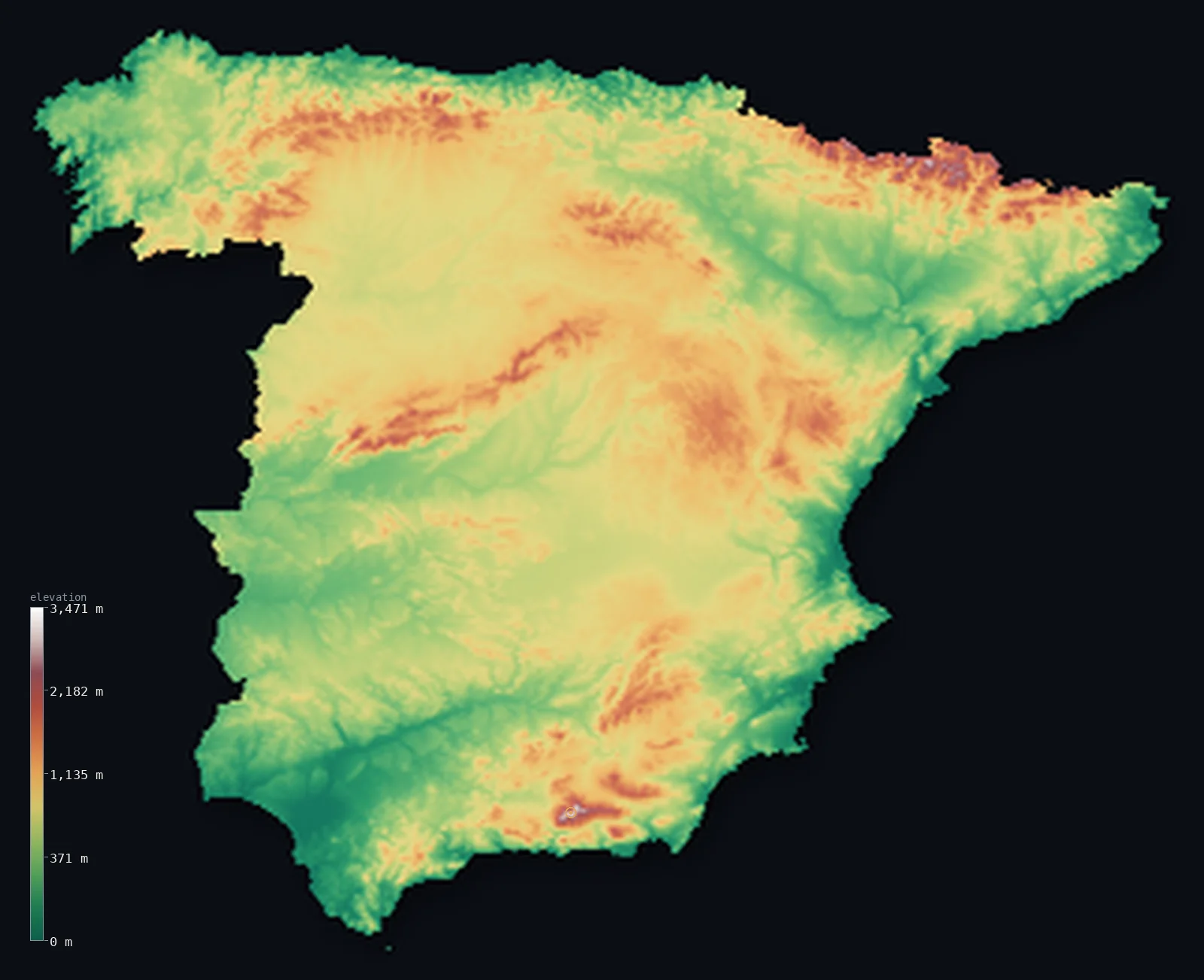
Spain’s highest point is Mulhacen at 11,414 ft (3,479 m); its lowest is Atlantic Ocean and Mediterranean Sea at 0 ft (0 m); the mean elevation is 2,274 ft (693 m).
Spain is a high country built around a tableland. Most of the interior is the Meseta, a vast plateau mostly above 600 m, ringed and crossed by mountain ranges — which is why half of Spain lies above 2,247 ft (685 m), one of the highest median elevations in Europe. The highest peak on the Spanish mainland is Mulhacén, at 11,414 ft (3,479 m) in the far south; the country's true summit, though, stands on a distant island.
- Highest point📚
- 11,414 ft3,479 m
- The highest point on the Spanish mainland is Mulhacén at 11,414 ft (3,479 m), in the Sierra Nevada of the far south — but Spain's true national high point is Teide, a volcano reaching 12,198 ft (3,718 m) on the Canary Island of Tenerife, off the coast of Africa and outside this map.
- Lowest point📚
- 0 ft0 m
- Spain's lowest point is simply its coastline at sea level, where the high interior and its mountain rims finally descend to the Atlantic and the Mediterranean.
- Mean elevation⚙
- 2,274 ft693 m
- Spain's mean elevation computed from the GLO-30 model is 2,274 ft (693 m) — one of the highest in Europe, and the direct result of the Meseta, the great central plateau on which most of the country sits.
- Median elevation⚙
- 2,247 ft685 m
- Half of Spain lies above 2,247 ft (685 m) — remarkably high, and almost identical to the mean, because so much of the country is the raised, level surface of the Meseta rather than a mix of high and low.
- Elevation range📚
- 11,414 ft3,479 m
- From sea level at the coast to Mulhacén's 11,414 ft on the mainland, Spain's mainland range is modest for so high a country — because Spain sits up on its plateau throughout, rather than climbing from low ground to isolated peaks.
- Above 1,000 m (3,281 ft)⚙
- 19%
- About 19% of Spain rises above 1,000 m (3,281 ft) — the mountain ranges that ring and cross the Meseta: the Pyrenees, the Cantabrian range, the Sierra Nevada, and the central sierras — with much of the plateau itself sitting just below that line.
- Official area📚
- 195,124 mi²505,370 km²
- Spain covers about 195,000 sq mi (506,000 sq km), most of the Iberian Peninsula — a high, dry interior of tableland and sierra, rimmed by mountains and edged with coastal lowland on the Mediterranean and Atlantic.
- Forest cover📚
- 36.8%
- About 37% of Spain is forested — heaviest in the wetter northern mountains and thinnest across the dry central Meseta, where the plateau's climate leaves much of the land open and treeless.
Highest and lowest points
The highest point on the Spanish mainland is Mulhacén, 11,414 ft (3,479 m), in the Sierra Nevada near Granada in the far south. Spain's true national high point, however, is not on the mainland at all: it is Teide, a volcano rising to 12,198 ft (3,718 m) on the Canary Island of Tenerife, off the northwest coast of Africa — the highest point in all of Spain, and in the whole Atlantic, but lying far outside the area this map shows.
source ↗Spain's lowest point is its coastline at sea level. It is a telling detail for a country whose interior sits so high: from the raised Meseta and its mountain rims, the land only reaches the sea at the edges, along the Mediterranean and Atlantic coasts where most of the population and the great port cities are gathered.
source ↗Spain at a glance
Spain's highest point is not on the mainland - it is Teide, a 3,718 m volcano on the Canary Island of Tenerife; the mainland's highest peak is Mulhacén, 3,479 m.
source ↗Most of interior Spain is the Meseta, a high plateau mostly above 600 m, which gives the country one of the highest average elevations in Europe.
source ↗Madrid, at about 660 m, is the highest capital city in the European Union - a direct consequence of sitting on the central Meseta.
source ↗The Meseta is ringed and crossed by mountains - the Pyrenees, the Cantabrian range, the Sierra Nevada, and the central sierras - that wall off the plateau from the coasts.
source ↗Because of the high, dry interior, half of Spain lies above about 685 m - far higher than most European countries.
source ↗Spain's coastlines on the Mediterranean and Atlantic hold most of its people and cities, where the high interior finally drops to the sea.
source ↗
Elevation profile of Spain
The largest share of land, 24%, falls in the 500–750 m band, and 66% of the territory lies above 500 m (1,640 ft).
- below 500 m (1,640 ft)34%
- 500–1,000 m47%
- 1,000–2,000 m18%
- above 2,000 m (6,562 ft)1%
Highest peaks of Spain
| Peak | Elevation | Range | Note |
|---|---|---|---|
| Teide↗ | 12,198 ft3,718 m | Tenerife (Canary Islands) | Highest point of Spain and of any Atlantic island, an active volcano on Tenerife. |
| Mulhacen↗ | 11,414 ft3,479 m | Sierra Nevada | The highest point of mainland Spain and of the Iberian Peninsula, near Granada. |
| Aneto↗ | 11,168 ft3,404 m | Pyrenees | The highest peak of the Pyrenees, in the Maladeta massif on the northern border. |
| Torre de Cerredo↗ | 8,694 ft2,650 m | Picos de Europa (Cantabrian Mountains) | The highest peak of the Picos de Europa in the northern Cantabrian range. |
| Pico Almanzor↗ | 8,504 ft2,592 m | Sistema Central (Sierra de Gredos) | The high point of the Sistema Central, the range that crosses the Meseta west of Madrid. |
The high heart of Spain
The Meseta (the central plateau)
The core of Spain is the Meseta, a vast tableland mostly above 600 m that fills the centre of the country. Tilted and divided by low mountain ranges, it is high, dry, and open — the reason Spain sits so high on average, and the reason its capital, Madrid, is the loftiest in the EU.
The mountain rim
Ranges ring and cross the Meseta: the Pyrenees walling off France in the north, the Cantabrian mountains along the northern coast, the Sierra Nevada in the south with Mulhacén, the mainland's high point, and the central sierras cutting across the plateau itself.
The coasts and islands
Only at its edges does Spain come down to the sea — the Mediterranean coast in the east and south, the Atlantic in the northwest — where the great cities and most of the population lie. Beyond the mainland, the Canary Islands hold Teide, the country's true summit.
How to read this map
Color shows elevation; the raised relief shows real terrain. On this map Spain reads as a raised brown interior — the Meseta — edged and crossed by the sharper white of the mountain ranges, dropping to green only at the coasts.
The 3D relief is the actual GLO-30 elevation data, exaggerated vertically so the plateau and its rims both show; the ×N relief slider controls how much. Tap anywhere to read that point's exact elevation.
City elevations in Spain
Spanish cities reflect the high interior - Madrid sits at about 660 m on the central Meseta, the highest capital in the EU, while Barcelona, Valencia, and Seville lie low on the coasts and river lowlands where the plateau meets the sea.
| City | Population | Elevation |
|---|---|---|
| Madridcapitalthe capital, high on the central Meseta at about 660 m - the highest capital in the EU ↗ | 3,255,944 | 2,192 ft668 m |
| Barcelonaon the Mediterranean coast at sea level, backed by coastal hills ↗ | 1,686,208 | 138 ft42 m |
| Valencia | 824,340 | 85 ft26 m |
| Zaragoza | 686,986 | 686 ft209 m |
| Sevillain the low Guadalquivir valley of the southwest, near sea level ↗ | 686,741 | 43 ft13 m |
| Málaga | 592,346 | 66 ft20 m |
| Murcia | 471,982 | 177 ft54 m |
| Bilbao | 347,342 | 59 ft18 m |
| Córdoba | 325,708 | 381 ft116 m |
| Valladolid | 300,618 | 2,303 ft702 m |
Elevation sampled at each city centre from the Copernicus GLO-30 model. Cities and population from GeoNames (CC-BY 4.0).
Spain in comparison
Spain's terrain rises 11,414 ft (3,479 m) from sea level to Mulhacen — about 39% of the height of Mount Everest, the world's highest point at 29,032 ft (8,849 m).
- Portugal's mean elevation is 1,043 ft — 1,230 ft lower; its high point, Torre, reaches 6,539 ft (1,993 m), 4,875 ft below. Portugal elevation map →
- France's mean elevation is 1,122 ft — 1,152 ft lower; its high point, Mont Blanc, reaches 15,768 ft (4,806 m), 4,354 ft above. France elevation map →
- Italy's mean elevation is 1,814 ft — 459 ft lower; its high point, Monte Bianco (Mont Blanc), reaches 15,768 ft (4,806 m), 4,354 ft above. Italy elevation map →
Frequently asked questions
What is the highest point in Spain?
- Spain's true high point is Teide, a 12,198 ft (3,718 m) volcano on the Canary Island of Tenerife. The highest peak on the Spanish mainland is Mulhacén, 11,414 ft (3,479 m), in the Sierra Nevada.
What is the lowest point in Spain?
- Sea level, along the Mediterranean and Atlantic coasts - the high interior only reaches the sea at the country's edges.
Why is Spain so high on average?
- Most of interior Spain is the Meseta, a plateau mostly above 600 m, which lifts the country's average elevation to one of the highest in Europe.
What is the highest capital city in Europe?
- Madrid, at about 660 m, is the highest capital in the European Union - because it sits on the central Meseta.
What is the average elevation of Spain?
- Computed from the GLO-30 model, Spain's area-weighted mean is 2,274 ft (693 m) - one of the highest in Europe, the direct result of the central Meseta on which most of the country sits.
Is this a topographic, relief, contour, or elevation map of Spain?
- They describe the same thing - terrain height. This page renders the country's actual elevation surface in interactive 3D and reports the statistics computed from it.
About this map
The terrain is rendered from the Copernicus GLO-30 digital elevation model (ESA), masked to the ESP-ADM0 boundary from geoBoundaries (gbOpen). Elevation statistics are computed directly from the model; peak names and researched facts are sourced and cited. See the methodology for the full pipeline.
Our area-weighted mean, computed from the Copernicus GLO-30 model, is 2,274 ft (693 m); the figure commonly cited elsewhere is 2,165 ft (660 m) (CIA World Factbook). Spain is Europe's second most mountainous country, built around a high central plateau, the Meseta, mostly between 600 and 760 m and rimmed by mountain ranges - so its mean elevation is high; the page reports the area-weighted figure computed from the Copernicus GLO-30 model.
Surveyed national figures: official area · forest cover · high point.
Rendered from Copernicus GLO-30 (ESA, 2021 release), boundaries from geoBoundaries. Generated 2026-07-07.
Bordering countries · 4
Spain shares a land border with these countries — open any one to compare its terrain and highest point.