Andorra Elevation Map — Topographic & 3D Terrain
Explore the terrain of Andorra in interactive 3D, built from Copernicus GLO-30 satellite elevation data — a microstate high in the eastern Pyrenees, made entirely of mountains and valleys. Drag to rotate, scroll to zoom, and tap any point to read its elevation.
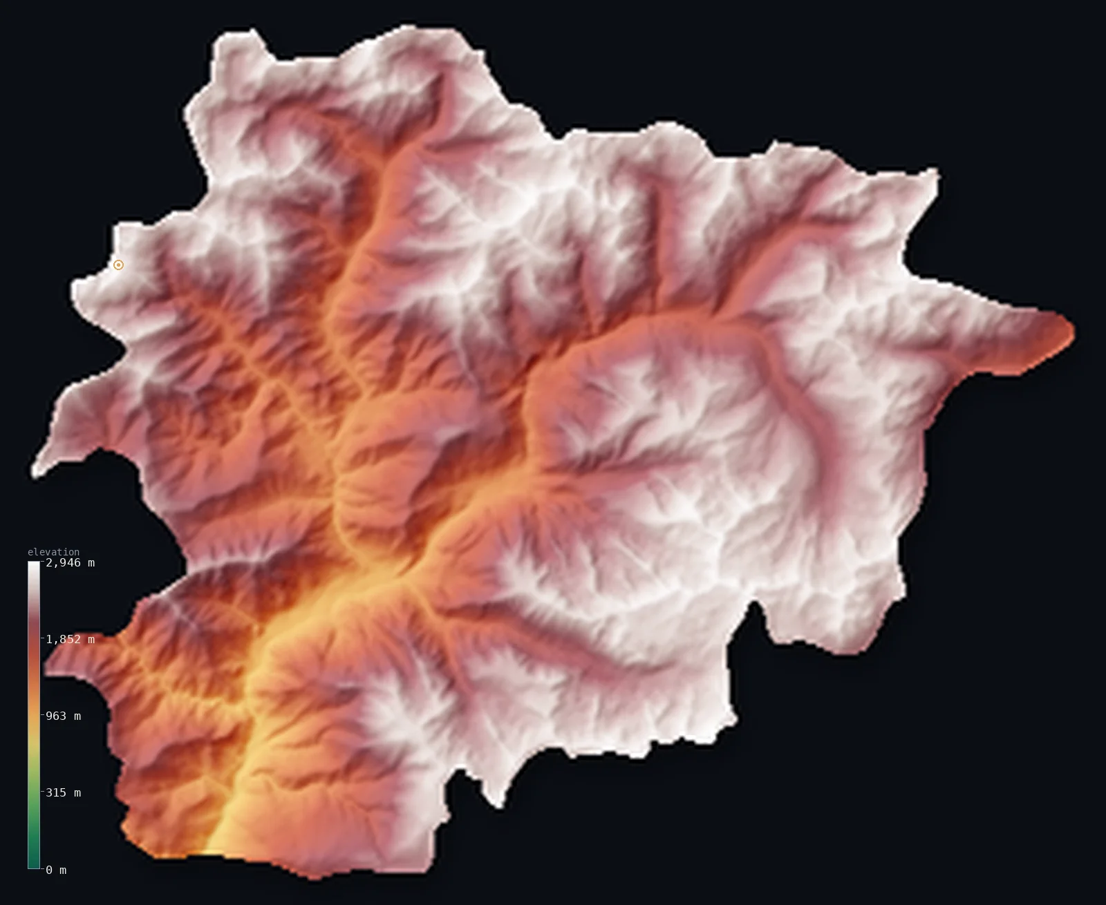
Andorra’s highest point is Coma Pedrosa at 9,656 ft (2,943 m); its lowest is Gran Valira river (at the Spanish border) at 2,756 ft (840 m); the mean elevation is 6,722 ft (2,049 m).
Andorra is a country made entirely of mountains — a microstate high in the eastern Pyrenees, between France and Spain, with no lowland at all. Its whole territory is steep valleys and high ridges; even its lowest point, where the Gran Valira river leaves for Spain, sits at 2,756 ft (840 m), and nowhere in the country lies below that. Its mean elevation, 6,722 ft (2,049 m), is the highest of any country in Western Europe — higher even than Switzerland — and it rises to Coma Pedrosa at 9,656 ft (2,943 m). Nearly 60% of Andorra stands above 2,000 m.
- Highest point📚
- 9,656 ft2,943 m
- Andorra's highest point is Coma Pedrosa at 9,656 ft (2,943 m), in the northwest of the country — a rocky Pyrenean summit, the tallest of the peaks that ring Andorra's high valleys. In a country that is entirely mountainous, it is the highest of many high points, standing above a landscape where even the valley floors lie above 900 m.
- Lowest point📚
- 2,756 ft840 m
- Andorra's lowest point is where the Gran Valira river flows out of the country into Spain, at 2,756 ft (840 m). It is an extraordinarily high point for a country's lowest — the floor of a mountain valley, not a plain — and from it the land climbs steeply in every direction into the Pyrenees.
- Mean elevation⚙
- 6,722 ft2,049 m
- Computed from the GLO-30 model, Andorra's mean elevation is 6,722 ft (2,049 m) — the highest of any country in Western Europe, higher than Switzerland's, and a direct measure of a microstate that is nothing but high Pyrenean mountain: steep valleys and high ridges from border to border.
- Median elevation⚙
- 6,965 ft2,123 m
- Half of Andorra lies above 6,965 ft (2,123 m) — a midpoint that sits above 2,000 m, higher than the summit of many a country, and higher than Andorra's own mean: the bulk of the land is high slope and ridge, the valley floors a minority.
- Elevation range📚
- 6,900 ft2,103 m
- Even Andorra's full vertical range — about 6,900 ft, from the 840 m Gran Valira to the 2,943 m summit of Coma Pedrosa — is a climb between highs: not lowland to mountain, but high valley floor to higher peak, all of it in the Pyrenees.
- Above 1,000 m (3,281 ft)⚙
- 99%
- About 99% of Andorra rises above 1,000 m (3,281 ft) — which is to say very nearly all of it, since even the valley floors lie near 1,000 m and the country has no lower ground. Only the deepest valley bottoms fall below that line.
- Above 2,000 m (6,562 ft)⚙
- 59%
- Roughly 59% of Andorra stands above 2,000 m (6,562 ft) — more than half the country, the high slopes and ridges above the valley floors. Andorra is one of the very few countries of which the majority lies above 2,000 m.
- Official area📚
- 181 mi²468 km²
- Andorra covers only about 181 sq mi (468 sq km) — a tiny country high in the eastern Pyrenees between France and Spain, made up entirely of high mountain valleys and the ridges that divide them.
- Forest cover📚
- 34%
- About 34.0% of Andorra is forested — pine and fir on the valley sides up to the treeline, giving way above to alpine meadow, bare rock, and the high ridges; the steep terrain leaves the upper country open and treeless.
Highest and lowest points
Andorra's highest point is Coma Pedrosa, 9,656 ft (2,943 m), in the northwest of the country near the borders with both France and Spain. It is a rugged Pyrenean peak of rock and scree, the tallest of the many summits that enclose Andorra's high valleys, with small glacial lakes in the cirques below it. In a country that is entirely mountain, Coma Pedrosa is simply the highest point of a very high land — one where the valley floors themselves lie above 900 m and more than half the country stands above 2,000 m.
source ↗Andorra's lowest point is where the Gran Valira — the river formed by the joining of Andorra's main valleys — flows out of the country into Spain, at 2,756 ft (840 m) above sea level. It is one of the highest 'lowest points' of any country on Earth: even the very bottom of Andorra is a high mountain valley floor. Andorra sits astride the crest of the eastern Pyrenees, and its rivers all gather into the Valira, which drains south toward the Segre and eventually the Ebro.
source ↗Andorra at a glance
All of Andorra is mountainous and even its lowest point sits at 840 m, giving it a mean elevation of about 6,722 ft (2,049 m) — one of the highest of any country on Earth.
source ↗Andorra packs 65 peaks above 2,000 m into just 468 km² — it is the largest of Europe's microstates but is essentially a cluster of Pyrenean valleys.
source ↗Andorra la Vella, at about 1,020 m, is the highest capital city in Europe.
source ↗The whole country drains through a single Y-shaped river system: two valleys, the Valira del Nord and Valira d'Orient, merge into the Gran Valira, which exits south into Spain.
source ↗Andorra has the largest ski terrain in the Pyrenees — about 350 km of slopes across some 3,100 hectares — thanks to its uniformly high, snowy mountains.
source ↗Over 170 small glacial lakes dot Andorra's high cirques, relics of past ice ages, feeding a dense network of more than 300 mountain watercourses.
source ↗The Madriu-Perafita-Claror valley — a roadless tenth of the country — is a UNESCO World Heritage site preserving a traditional Pyrenean pastoral landscape.
source ↗
Elevation profile of Andorra
The largest share of land, 20%, falls in the 2,200–2,400 m band, and 100% of the territory lies above 500 m (1,640 ft).
- 500–1,000 m1%
- 1,000–2,000 m40%
- above 2,000 m (6,562 ft)59%
Highest peaks of Andorra
| Peak | Elevation | Range | Note |
|---|---|---|---|
| Coma Pedrosa↗ | 9,656 ft2,943 m | Pyrenees | Highest point of Andorra, a pyramid peak in the northwest near the France–Spain border tripoint. |
| Pic de l'Estanyó↗ | 9,564 ft2,915 m | Pyrenees | A high peak in the north near El Serrat, beside the Estany de l'Estanyó lake. |
| Pic de Médécourbe↗ | 9,560 ft2,914 m | Pyrenees | A peak on the western border where Andorra, France and Spain meet. |
| Pic de la Portelleta↗ | 9,531 ft2,905 m | Pyrenees | A high summit on the southern border ridge. |
| Pic dels Pessons↗ | 9,400 ft2,865 m | Pyrenees | A peak in the east above the Grandvalira ski area, near a cirque of glacial lakes. |
| Pic d'Envalira↗ | 9,268 ft2,825 m | Pyrenees | A peak in the east near the high Envalira pass, the highest paved mountain pass in the Pyrenees. |
Andorra: the high peaks, the Y-shaped Valira valleys, and the Madriu
The high peaks and ranges
Andorra's highest ground rings the north and west. Coma Pedrosa (2,943 m) crowns the northwest, in a cluster of pyramid peaks, glacial cirques, and tarns above the Arinsal valley; high ridges wall the north and east, among them Pic de l'Estanyó (2,915 m) and Pic d'Envalira. More than 170 small glacial lakes dot these high cirques, relics of past ice ages that feed the rivers below.
The Valira valleys
The country drains through a single Y-shaped river system: two narrow valleys — the Valira del Nord and the Valira d'Orient — join at Escaldes-Engordany to form the Gran Valira, which runs south past Andorra la Vella and out into Spain. These valley floors, high as they are, hold nearly all of Andorra's towns and people; Andorra la Vella, at about 1,020 m, is the highest capital in Europe.
The Madriu and the high pastures
In the southeast lies the Madriu-Perafita-Claror valley — a roadless glacial valley, about a tenth of the country — of steep slopes, summer pastures, and stone shelters, a UNESCO World Heritage cultural landscape preserving a traditional Pyrenean pastoral way of life. Andorra's uniformly high, snowy mountains also carry the largest ski terrain in the Pyrenees, about 350 km of slopes.
How to read this map
Color shows elevation; the raised relief shows real terrain. Andorra reads almost entirely in the high greens, blues, and whites of the Pyrenees — every part of it is mountain, from the valley floors above 840 m to Coma Pedrosa's 2,943 m summit, with the Y of the Valira valleys threading between the peaks.
The 3D relief is the actual GLO-30 elevation data, exaggerated vertically so the terrain reads clearly; the ×N relief slider controls how much. Tap anywhere to read that point's exact elevation.
City elevations in Andorra
Andorra's towns sit on the valley floors — Andorra la Vella, the capital, where the two main valleys meet, and the villages of the parishes strung along the Valira rivers. Even these valley-floor settlements lie high, above 1,000 m; there is nowhere lower to build.
| City | Population | Elevation |
|---|---|---|
| Andorra la Vellacapitalthe capital, on the valley floor where the Valira rivers meet — the highest capital in Europe, above 1,000 m ↗ | 20,430 | 3,406 ft1,038 m |
| Pas de la Casaa high ski town on the French border in the east, near 2,000 m ↗ | 2,363 | 6,949 ft2,118 m |
Elevation sampled at each city centre from the Copernicus GLO-30 model. Cities and population from GeoNames (CC-BY 4.0).
Andorra in comparison
Andorra's terrain rises 6,900 ft (2,103 m) from Gran Valira river (at the Spanish border) (2,756 ft (840 m)) to Coma Pedrosa — about 24% of the height of Mount Everest, the world's highest point at 29,032 ft (8,849 m).
- Switzerland's mean elevation is 4,301 ft — 2,421 ft lower; its high point, Dufourspitze (Monte Rosa), reaches 15,203 ft (4,634 m), 5,548 ft above. Switzerland elevation map →
- Slovenia's mean elevation is 1,860 ft — 4,862 ft lower; its high point, Triglav, reaches 9,396 ft (2,864 m), 259 ft below. Slovenia elevation map →
- Austria's mean elevation is 3,127 ft — 3,596 ft lower; its high point, Grossglockner, reaches 12,461 ft (3,798 m), 2,805 ft above. Austria elevation map →
Frequently asked questions
What is the highest point in Andorra?
- Coma Pedrosa, 9,656 ft (2,943 m), a Pyrenean peak in the northwest — the tallest of the many summits that ring Andorra's high valleys.
What is the lowest point in Andorra?
- Where the Gran Valira river leaves for Spain, at 2,756 ft (840 m) — one of the highest lowest-points of any country, since even Andorra's lowest ground is a high valley floor.
What is the average elevation of Andorra?
- About 6,722 ft (2,049 m), computed from the Copernicus GLO-30 model — the highest mean elevation of any country in Western Europe, higher than Switzerland's, because Andorra is entirely high Pyrenean valleys and ridges.
Is Andorra the highest country in Europe?
- It has the highest mean elevation in Western Europe, higher than Switzerland — and unusually, more than half of it lies above 2,000 m. Its lowest point is still 840 m up.
How high is Andorra la Vella?
- The capital sits at over 1,000 m on the valley floor where Andorra's main valleys meet — the highest capital city in Europe.
Is this a topographic, relief, contour, or elevation map of Andorra?
- They describe the same thing — terrain height. This page renders the country's actual elevation surface in interactive 3D and reports the statistics computed from it.
About this map
The terrain is rendered from the Copernicus GLO-30 digital elevation model (ESA), masked to the AND-ADM0 boundary from geoBoundaries (gbOpen). Elevation statistics are computed directly from the model; peak names and researched facts are sourced and cited. See the methodology for the full pipeline.
Our area-weighted mean, computed from the Copernicus GLO-30 model, is 6,722 ft (2,049 m); the figure commonly cited elsewhere is 6,549 ft (1,996 m) (Wikipedia / Andorran geography). All of Andorra is mountainous and even its lowest point sits at 840 m, so its mean elevation is among the very highest of any country; the page reports the area-weighted figure computed from the Copernicus GLO-30 model, about 2,049 m; the ~1,996 m cited elsewhere sits just below it.
Surveyed national figures: official area · forest cover · high point.
Rendered from Copernicus GLO-30 (ESA, 2021 release), boundaries from geoBoundaries. Generated 2026-06-22.
Bordering countries · 2
Andorra shares a land border with these countries — open any one to compare its terrain and highest point.