Austria Elevation Map — Topographic & 3D Terrain
Explore the terrain of Austria in interactive 3D, built from Copernicus GLO-30 satellite elevation data — the eastern Alps, tapering to the Danube lowlands in the east. Drag to rotate, scroll to zoom, and tap any point to read its elevation.
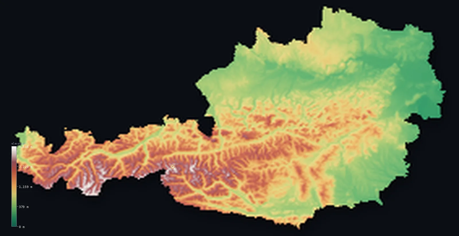
Austria’s highest point is Grossglockner at 12,461 ft (3,798 m); its lowest is Neusiedler See at 377 ft (115 m); the mean elevation is 3,127 ft (953 m).
Austria is where the Alps come to an end. The great range fills the west and south of the country in a succession of glaciated ranges — the Ötztal, the Hohe Tauern, and more — carrying Grossglockner to 12,461 ft (3,798 m). But eastward the mountains lose height and give way: the land steps down through hills and basins to the flat valley of the Danube and the plains around Vienna, where Austria's lowest point lies barely above the level of a lake. About 38% of the country still stands above 3,281 ft (1,000 m).
- Highest point📚
- 12,461 ft3,798 m
- Austria's highest point is Grossglockner at 12,461 ft (3,798 m), in the Hohe Tauern of the central eastern Alps — a sharp, glaciated peak beside the Pasterze, the longest glacier in the eastern Alps. It is the high point of a country whose western half is almost entirely mountain.
- Lowest point📚
- 377 ft115 m
- Austria's lowest point is the shore of Neusiedler See at about 377 ft (115 m), a large, shallow steppe lake on the Hungarian border east of Vienna — the low, flat edge of a landlocked country whose opposite corner rises to nearly 3,800 m.
- Mean elevation⚙
- 3,127 ft953 m
- Computed from the GLO-30 model, Austria's mean elevation is 3,127 ft (953 m) — a high average, reflecting a country whose western and southern two-thirds are filled by the Alps, balanced against the lower Danube valley and the eastern lowlands.
- Median elevation⚙
- 2,507 ft764 m
- Half of Austria lies above 2,507 ft (764 m) — a high median, the mark of a genuinely mountainous country: the typical point sits well up in Alpine or pre-Alpine terrain, with only the eastern lowlands and the river valleys falling below.
- Elevation range📚
- 12,083 ft3,683 m
- From the shore of Neusiedler See to the summit of Grossglockner, Austria spans about 12,080 ft — from a shallow steppe lake in the east to a glaciated Alpine peak in the west, nearly all of the height held in the Alps that fill the country's western two-thirds.
- Above 1,000 m (3,281 ft)⚙
- 38%
- About 38% of Austria rises above 1,000 m (3,281 ft) — the Alpine ranges of the west and south, which cover the majority of the country. The eastern third, around the Danube and Vienna, is far lower.
- Above 2,000 m (6,562 ft)⚙
- 9%
- Roughly 9% of Austria stands above 2,000 m (6,562 ft) — the high Alpine country of Tyrol, Salzburg, and Carinthia, the glaciated ranges of the Hohe Tauern and Ötztal where the peaks and the ski country lie.
- Official area📚
- 32,383 mi²83,871 km²
- Austria covers about 32,400 sq mi (83,871 sq km) — a landlocked Alpine country in central Europe, its western two-thirds filled by mountains and its eastern third opening to the Danube valley and the Pannonian plain.
- Forest cover📚
- 47.2%
- About 47.2% of Austria is forested — nearly half the country, from the montane spruce forests of the Alps to the mixed woodland of the lower hills and the Vienna Woods.
Highest and lowest points
Austria's highest point is Grossglockner, 12,461 ft (3,798 m), in the Hohe Tauern range of the central Alps — a steep, pyramidal peak, the highest in Austria and one of the most prominent in the Alps. At its foot lies the Pasterze, the longest glacier in the eastern Alps, though it has been retreating for over a century. The mountain rises on the border between Carinthia, Tyrol, and Salzburg, in the heart of the country's highest and most glaciated terrain, and gives its name to the high Alpine road that climbs beneath it.
source ↗Austria's lowest point is the shore of Neusiedler See, about 377 ft (115 m) above sea level, on the Hungarian border east of Vienna. It is a large, shallow, reed-fringed steppe lake — the westernmost of the Eurasian steppe lakes — lying in the flat Pannonian lowland that reaches into Austria's eastern edge. It could hardly contrast more with the country's west: from here the land climbs, across the whole width of Austria, to the glaciers of the Hohe Tauern nearly 3,700 m higher.
source ↗Austria at a glance
Grossglockner (3,798 m), Austria's highest peak, stands above the Pasterze — the longest glacier in the eastern Alps, though it has retreated markedly over the past century.
source ↗The Alps fill roughly the western two-thirds of Austria, tapering eastward to the Danube valley and the Pannonian lowlands around Vienna.
source ↗Austria's lowest point, the shore of Neusiedler See, is a shallow steppe lake on the Hungarian border — the westernmost of the great Eurasian steppe lakes.
source ↗The Danube crosses northern Austria from west to east, through the Wachau valley and Vienna — the country's main lowland corridor through otherwise hilly and mountainous terrain.
source ↗About 38% of Austria lies above 1,000 m, and nearly half the country is forested — one of the more mountainous nations in Europe.
source ↗The Hohe Tauern, holding Grossglockner, form the highest range of the eastern Alps and one of the largest protected areas in the Alps.
source ↗Grossglockner became Austria's highest mountain only in 1919: the previously higher Ortler was ceded to Italy under the Treaty of Saint-Germain after the First World War.
source ↗
Elevation profile of Austria
The largest share of land, 22%, falls in the 250–500 m band, and 69% of the territory lies above 500 m (1,640 ft).
- below 500 m (1,640 ft)31%
- 500–1,000 m30%
- 1,000–2,000 m29%
- above 2,000 m (6,562 ft)9%
Highest peaks of Austria
| Peak | Elevation | Range | Note |
|---|---|---|---|
| Grossglockner↗ | 12,461 ft3,798 m | Hohe Tauern | Highest point of Austria and of the Eastern Alps; a pyramid peak above the Pasterze glacier. |
| Wildspitze↗ | 12,362 ft3,768 m | Ötztal Alps | Austria's second-highest mountain and the highest of the Ötztal Alps, a glaciated double summit in Tyrol. |
| Weißkugel↗ | 12,267 ft3,739 m | Ötztal Alps | Third-highest in Austria, on the Italian border in the Ötztal Alps. |
| Großvenediger↗ | 11,998 ft3,657 m | Hohe Tauern (Venediger Group) | A heavily glaciated peak in the Hohe Tauern, on the Tyrol–Salzburg border. |
| Großes Wiesbachhorn↗ | 11,693 ft3,564 m | Hohe Tauern (Glockner Group) | An elegant pyramid in the Glockner Group; early climbers once mistook it for Austria's highest. |
| Hoher Dachstein↗ | 9,826 ft2,995 m | Northern Limestone Alps (Dachstein) | Highest peak of the Northern Limestone Alps, a glaciated massif shared by three states north of the central crest. |
The high Alps, the foothills, and the Danube east
The high Alps (west and south)
The western and southern two-thirds of Austria are Alpine — a succession of glaciated ranges including the Ötztal Alps, the Hohe Tauern with Grossglockner, and the ranges of Tyrol, Salzburg, and Carinthia. This is the country's highest, most glaciated, and most famous terrain, the heart of its ski country.
The Northern Limestone Alps and the foothills
North of the central crystalline ranges run the Northern Limestone Alps and, beyond them, the Alpine foothills — lower ranges of limestone peaks, lakes, and forested hills descending toward the Danube, gentler than the high Alps but still decidedly upland.
The Danube valley and the north
The Danube crosses the north of the country from west to east, through the Wachau and past Linz and Vienna — Austria's main lowland corridor. North of it, in the Waldviertel and Mühlviertel, lie the low, rolling, forested hills of the Bohemian Massif reaching down from Czechia.
The eastern lowlands
In the east, around and south of Vienna, the Alps give way at last to the Pannonian plain — the flat, warm, agricultural lowland of the Vienna Basin and the Neusiedler See, reaching toward Hungary. This is Austria's lowest and most open country.
How to read this map
Color shows elevation; the raised relief shows real terrain. On this map Austria reads as a country tilted east — a mass of white-and-brown high Alps filling the west and south, stepping down through browns and greens across the centre to the low green of the Danube valley and the eastern plains around Vienna.
The 3D relief is the actual GLO-30 elevation data, exaggerated vertically so the high Alps and the lowland corridor both show; the ×N relief slider controls how much. Tap anywhere to read that point's exact elevation.
City elevations in Austria
Austria's cities sit mostly in the lower east and along the Danube — Vienna on the river in the east, Linz upstream, Graz in the southeastern basins — with Innsbruck and Salzburg set among the mountains of the west. The high Alps hold few large towns.
| City | Population | Elevation |
|---|---|---|
| Viennacapitalthe capital, on the Danube in the eastern lowlands where the Alps give way to the plain ↗ | 1,691,468 | 636 ft194 m |
| Grazin the southeastern basins on the Mur river ↗ | 303,270 | 1,178 ft359 m |
| Linz | 204,846 | 879 ft268 m |
| Salzburgat the northern foot of the Alps near the German border ↗ | 157,245 | 1,417 ft432 m |
| Innsbruckin the Inn valley of Tyrol, ringed by the high Alps ↗ | 132,493 | 1,919 ft585 m |
| Klagenfurt am Wörthersee | 100,316 | 1,480 ft451 m |
| Passau | 50,560 | 1,204 ft367 m |
| Dornbirn | 49,278 | 1,444 ft440 m |
| Wiener Neustadt | 44,820 | 892 ft272 m |
| Karlova Ves | 35,644 | 587 ft179 m |
Elevation sampled at each city centre from the Copernicus GLO-30 model. Cities and population from GeoNames (CC-BY 4.0).
Austria in comparison
Austria's terrain rises 12,083 ft (3,683 m) from Neusiedler See (377 ft (115 m)) to Grossglockner — about 42% of the height of Mount Everest, the world's highest point at 29,032 ft (8,849 m).
- Switzerland's mean elevation is 4,301 ft — 1,175 ft higher; its high point, Dufourspitze (Monte Rosa), reaches 15,203 ft (4,634 m), 2,743 ft above. Switzerland elevation map →
- Slovenia's mean elevation is 1,860 ft — 1,266 ft lower; its high point, Triglav, reaches 9,396 ft (2,864 m), 3,064 ft below. Slovenia elevation map →
- Norway's mean elevation is 1,831 ft — 1,296 ft lower; its high point, Galdhopiggen, reaches 8,100 ft (2,469 m), 4,360 ft below. Norway elevation map →
Frequently asked questions
What is the highest point in Austria?
- Grossglockner, 12,461 ft (3,798 m), in the Hohe Tauern of the central Alps — a glaciated peak above the Pasterze, the longest glacier in the eastern Alps.
What is the lowest point in Austria?
- The shore of Neusiedler See, about 377 ft (115 m), a shallow steppe lake on the Hungarian border east of Vienna.
What is the average elevation of Austria?
- Computed from the Copernicus GLO-30 model, the area-weighted mean is 3,127 ft (953 m) — high, because the Alps fill the western two-thirds of the country, balanced by the lower Danube valley and eastern plains.
Is Austria mountainous?
- Largely — about 38% stands above 1,000 m and the median elevation is over 760 m. The Alps fill the west and south; only the eastern third, around the Danube and Vienna, is low.
Where are the Austrian Alps?
- Across the western and southern two-thirds of the country — Tyrol, Salzburg, Carinthia, and beyond — with the highest ranges, the Hohe Tauern and Ötztal, holding Grossglockner and the glaciers. The land lowers eastward to the Danube and Vienna.
Is this a topographic, relief, contour, or elevation map of Austria?
- They describe the same thing — terrain height. This page renders the country's actual elevation surface in interactive 3D and reports the statistics computed from it.
About this map
The terrain is rendered from the Copernicus GLO-30 digital elevation model (ESA), masked to the AUT-ADM0 boundary from geoBoundaries (gbOpen). Elevation statistics are computed directly from the model; peak names and researched facts are sourced and cited. See the methodology for the full pipeline.
Our area-weighted mean, computed from the Copernicus GLO-30 model, is 3,127 ft (953 m); the figure commonly cited elsewhere is 2,986 ft (910 m) (CIA World Factbook). The Alps cover well over half of Austria, so the mean is among the highest in Europe despite the flat Danube valley and Pannonian east; the page reports the area-weighted figure computed from the Copernicus GLO-30 model.
Surveyed national figures: official area · forest cover · high point.
Rendered from Copernicus GLO-30 (ESA, 2021 release), boundaries from geoBoundaries. Generated 2026-06-21.
Bordering countries · 8
Austria shares a land border with these countries — open any one to compare its terrain and highest point.