Liechtenstein Elevation Map — Topographic & 3D Terrain
Explore the terrain of Liechtenstein in interactive 3D, built from Copernicus GLO-30 satellite elevation data — a tiny country climbing from the Rhine valley to the Alps between Switzerland and Austria. Drag to rotate, scroll to zoom, and tap any point to read its elevation.
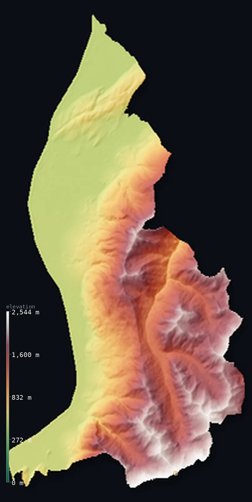
Liechtenstein’s highest point is Grauspitz (Vorder-Grauspitz) at 8,527 ft (2,599 m); its lowest is Ruggeller Riet at 1,411 ft (430 m); the mean elevation is 3,579 ft (1,091 m).
Liechtenstein climbs from a river to the Alps in the space of a few miles. One of the world's smallest countries, wedged between Switzerland and Austria, it is a country of two halves: the flat floor of the Rhine valley in the west — where the river forms the entire Swiss border and where nearly all the towns and people are — and the steep Alps rising straight up to the east, climbing to Vorder-Grauspitz at 8,527 ft (2,599 m). Half of the little country lies above 3,281 ft (1,000 m), and it is one of only two doubly landlocked countries on Earth.
- Highest point📚
- 8,527 ft2,599 m
- Liechtenstein's highest point is Vorder-Grauspitz at 8,527 ft (2,599 m), on the southern border with Switzerland — a peak in the Rätikon range of the Alps that rise along the country's eastern and southern edge. Its summit sits on the frontier; the highest ground fully within the country lies just beside it. It is the high point of the mountains that fill the eastern two-thirds of this tiny state.
- Lowest point📚
- 1,411 ft430 m
- Liechtenstein's lowest point is the Ruggeller Riet at about 1,411 ft (430 m), a marshy lowland in the north near the Rhine — the low, flat floor of the Rhine valley, which forms the country's western edge and holds nearly all of its population.
- Mean elevation⚙
- 3,579 ft1,091 m
- Liechtenstein's mean elevation, computed from the GLO-30 model, is 3,579 ft (1,091 m) — lifted by its split: a low, flat Rhine-valley floor in the west where the people live, and the steep Alps filling the eastern two-thirds and pulling the average sharply up.
- Median elevation⚙
- 3,396 ft1,035 m
- Half of Liechtenstein lies above 3,396 ft (1,035 m) — high, in a country whose people nearly all live low: they crowd the Rhine-valley floor, but most of the country's land is the mountain behind it, so half of Liechtenstein by area is up in the Alps.
- Elevation range📚
- 7,116 ft2,169 m
- Barely a few miles separate Liechtenstein's lowest ground from its highest — yet they differ by 7,116 ft, the Rhine-valley floor at 430 m rising to the 2,599 m summit of Vorder-Grauspitz almost within sight of it.
- Above 1,000 m (3,281 ft)⚙
- 51%
- About 51% of Liechtenstein rises above 1,000 m (3,281 ft) — roughly half the country, the Alps that fill its eastern and southern parts. The other half is the low Rhine valley floor in the west, where the towns and people are.
- Above 2,000 m (6,562 ft)⚙
- 5%
- Roughly 5% of Liechtenstein stands above 2,000 m (6,562 ft) — the higher Alpine ground along the eastern and southern borders, around Vorder-Grauspitz and the peaks of the Rätikon.
- Official area📚
- 62 mi²160 km²
- Liechtenstein covers only about 62 sq mi (160 sq km) — one of the smallest countries in the world, between Switzerland and Austria, split between the flat Rhine valley floor in the west and the steep Alps that fill its east.
- Forest cover📚
- 36.3%
- About 36.3% of Liechtenstein is forested — much of it on the mountain slopes above the Rhine valley, with forest climbing the steep eastern hillsides to the treeline; the valley floor itself is settled and farmed.
Highest and lowest points
Liechtenstein's highest point is Vorder-Grauspitz, 8,527 ft (2,599 m), on the southern border with Switzerland — a peak of the Rätikon, the Alpine range that walls the country's eastern and southern edge. Its summit lies exactly on the Swiss frontier; the highest ground entirely within Liechtenstein is a point just beside it, marginally lower. The mountains here fill the eastern two-thirds of the country, rising steeply from the Rhine valley floor in a few miles — so that this tiny state, most of whose people live down on the flat, contains genuine high Alps at its back.
source ↗Liechtenstein's lowest point is the Ruggeller Riet, at about 1,411 ft (430 m) — a protected marshland in the north of the country, on the flat floor of the Rhine valley near where the Rhine forms the border with Switzerland. The Rhine valley is Liechtenstein's western edge and its only real lowland: flat, low, and holding nearly all of the country's towns, industry, and population. From this narrow floor the land rises abruptly eastward into the Alps — within a very short distance, the country goes from valley marsh to high mountain.
source ↗Grauspitz (Vorder-Grauspitz) is a border summit: its peak lies about 2 km outside the generalized Liechtenstein boundary, so the highest fully in-territory land pixel in the model is 8,350 ft (2,545 m). The headline figure above is the surveyed elevation of the recognised national high point.
Liechtenstein at a glance
Liechtenstein is one of only two doubly landlocked countries on Earth - wholly surrounded by other landlocked countries (Switzerland and Austria) - the other being Uzbekistan.
source ↗Despite covering just 160 km2, Liechtenstein has 32 mountains above 2,000 m.
source ↗The Rhine forms the country's entire western border, and the valley floor where most people live was reclaimed from marshland in the 20th century.
source ↗The Naafkopf (2,570 m) marks the tripoint where Liechtenstein, Switzerland and Austria all meet.
source ↗Liechtenstein's lowest point, the Ruggeller Riet, is a protected moor and one of its most biodiverse nature reserves - not a coast, since the country never reaches the sea.
source ↗It is the world's smallest country to border two nations, and the sixth-smallest sovereign state overall.
source ↗
Elevation profile of Liechtenstein
The largest share of land, 38%, falls in the 400–600 m band, and 70% of the territory lies above 500 m (1,640 ft).
- below 500 m (1,640 ft)30%
- 500–1,000 m19%
- 1,000–2,000 m46%
- above 2,000 m (6,562 ft)5%
Highest peaks of Liechtenstein
| Peak | Elevation | Range | Note |
|---|---|---|---|
| Grauspitz (Vorder-Grauspitz)↗ | 8,527 ft2,599 m | Raetikon (Swiss border, south) | Highest point of Liechtenstein, in the Raetikon Alps on the Swiss border. |
| Naafkopf↗ | 8,432 ft2,570 m | Raetikon (Switzerland-Austria tripoint, south) | A popular summit marking the tripoint where Liechtenstein, Switzerland and Austria meet. |
| Falknishorn↗ | 8,045 ft2,452 m | Raetikon (south) | The fifth-highest summit in Liechtenstein and the southernmost point of the country. |
Liechtenstein: the Rhine valley and the Raetikon Alps
The Rhine valley (west)
The western third of Liechtenstein is the flat floor of the Alpine Rhine valley, around 430–450 m above sea level, with the Rhine itself forming the entire border with Switzerland. This reclaimed valley floor holds Vaduz, Schaan, and nearly all the country's people and farmland; at its northern end lies the Ruggeller Riet, a protected moor and the country's lowest ground, at about 1,411 ft (430 m).
The Raetikon Alps (east)
The eastern two-thirds rise abruptly from the valley into the Raetikon, a massif of the Central Eastern Alps shared with Switzerland and Austria. The slopes climb to Vorder-Grauspitz (2,599 m) on the southern Swiss border, with the Naafkopf (2,570 m) marking the tripoint of Liechtenstein, Switzerland, and Austria, and the Three Sisters (Drei Schwestern) on the Austrian border. Small as it is, the country packs 32 mountains above 2,000 m into this Alpine east.
How to read this map
Color shows elevation; the raised relief shows real terrain. The split is unmistakable: a flat blue-green ribbon of Rhine valley down the west, where the towns are, and the abrupt greens, browns, and whites of the Raetikon Alps filling the eastern two-thirds, rising to Grauspitz on the southern border.
The 3D relief is the actual GLO-30 elevation data, exaggerated vertically so the terrain reads clearly; the ×N relief slider controls how much. Tap anywhere to read that point's exact elevation.
City elevations in Liechtenstein
Liechtenstein's towns all sit on the Rhine valley floor in the west — Vaduz, the capital, and the others strung along the valley below the mountains. There are no towns in the Alpine east; the whole population lives on the low western ribbon.
| City | Population | Elevation |
|---|---|---|
| Vaduzcapitalthe capital, on the Rhine valley floor below the Alps ↗ | 5,197 | 1,535 ft468 m |
Elevation sampled at each city centre from the Copernicus GLO-30 model. Cities and population from GeoNames (CC-BY 4.0).
Liechtenstein in comparison
Liechtenstein's terrain rises 7,116 ft (2,169 m) from Ruggeller Riet (1,411 ft (430 m)) to Grauspitz (Vorder-Grauspitz) — about 25% of the height of Mount Everest, the world's highest point at 29,032 ft (8,849 m).
- Switzerland's mean elevation is 4,301 ft — 722 ft higher; its high point, Dufourspitze (Monte Rosa), reaches 15,203 ft (4,634 m), 6,677 ft above. Switzerland elevation map →
- Austria's mean elevation is 3,127 ft — 453 ft lower; its high point, Grossglockner, reaches 12,461 ft (3,798 m), 3,934 ft above. Austria elevation map →
- Andorra's mean elevation is 6,722 ft — 3,143 ft higher; its high point, Coma Pedrosa, reaches 9,656 ft (2,943 m), 1,129 ft above. Andorra elevation map →
Frequently asked questions
What is the highest point in Liechtenstein?
- Vorder-Grauspitz, 8,527 ft (2,599 m), on the southern border with Switzerland in the Rätikon Alps — its summit on the frontier, with the highest ground fully inside the country just beside it.
What is the lowest point in Liechtenstein?
- The Ruggeller Riet, about 1,411 ft (430 m), a marshland on the flat Rhine valley floor in the north.
What is the average elevation of Liechtenstein?
- Computed from the Copernicus GLO-30 model, the area-weighted mean is 3,579 ft (1,091 m) — high for so small a country, because the Alps fill its eastern two-thirds, though people live down on the low Rhine valley floor.
Is Liechtenstein mountainous?
- Half of it is — the Alps fill the eastern two-thirds, rising to nearly 2,600 m, while the western edge is the flat, low Rhine valley floor where nearly everyone lives. It packs real high Alps into a tiny area.
Why is Liechtenstein special geographically?
- It is one of only two doubly-landlocked countries on Earth — landlocked and bordered only by other landlocked countries (Switzerland and Austria) — and rises from the Rhine valley to high Alps in just a few miles.
Is this a topographic, relief, contour, or elevation map of Liechtenstein?
- They describe the same thing — terrain height. This page renders the country's actual elevation surface in interactive 3D and reports the statistics computed from it.
About this map
The terrain is rendered from the Copernicus GLO-30 digital elevation model (ESA), masked to the LIE-ADM0 boundary from geoBoundaries (gbOpen). Elevation statistics are computed directly from the model; peak names and researched facts are sourced and cited. See the methodology for the full pipeline.
Our area-weighted mean, computed from the Copernicus GLO-30 model, is 3,579 ft (1,091 m); no authority publishes a mean elevation (no authoritative published mean). About half of Liechtenstein is mountainous - the Raetikon Alps in the east - with the flat Rhine Valley filling the western third, so its mean elevation is high; the page reports the area-weighted figure computed from the Copernicus GLO-30 model.
Surveyed national figures: official area · forest cover · high point.
Rendered from Copernicus GLO-30 (ESA, 2021 release), boundaries from geoBoundaries. Generated 2026-06-23.
Bordering countries · 2
Liechtenstein shares a land border with these countries — open any one to compare its terrain and highest point.