Slovenia Elevation Map — Topographic & 3D Terrain
Explore the terrain of Slovenia in interactive 3D, built from Copernicus GLO-30 satellite elevation data — where the Alps meet the Dinarides, a small country almost entirely upland. Drag to rotate, scroll to zoom, and tap any point to read its elevation.
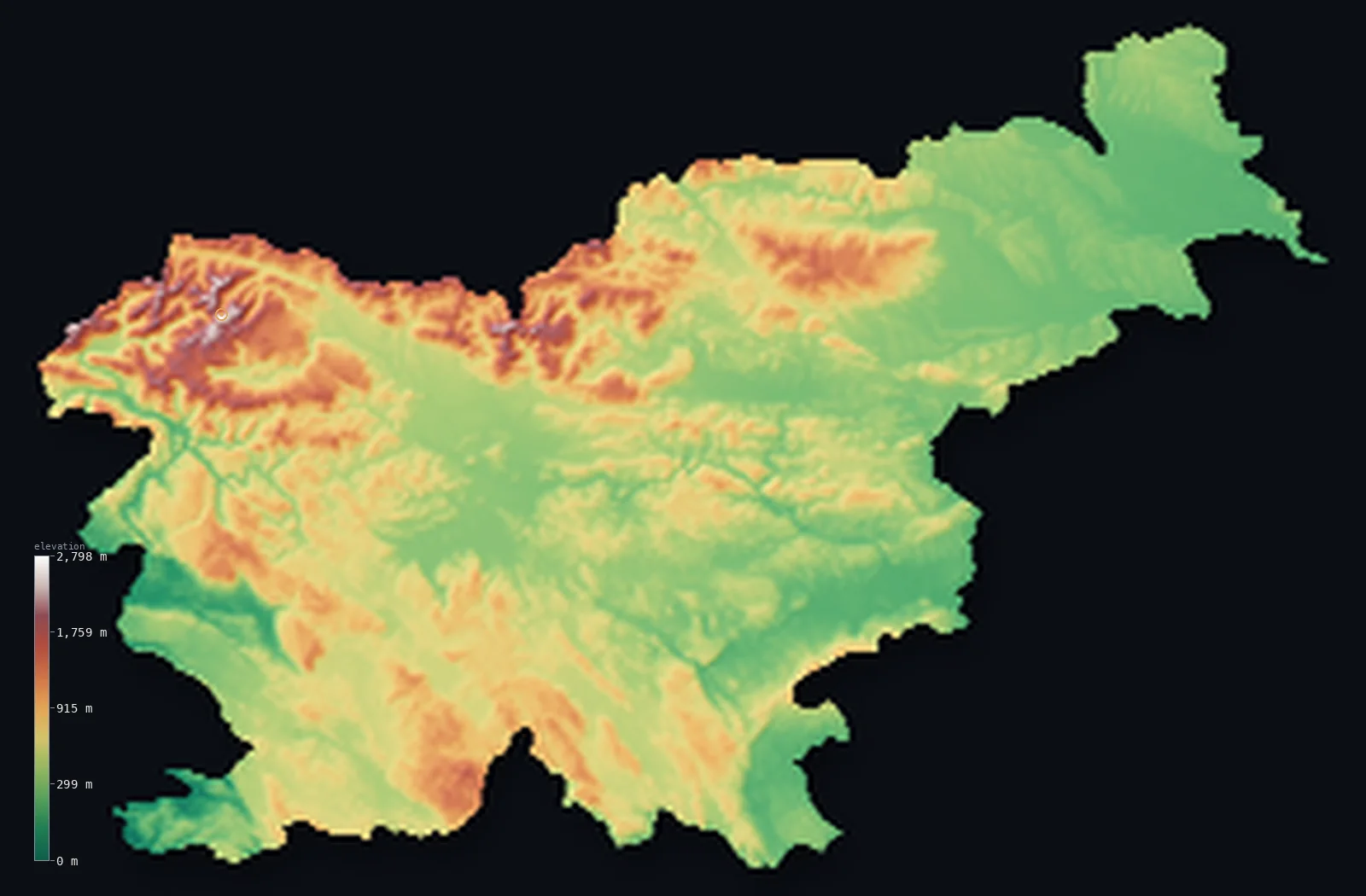
Slovenia’s highest point is Triglav at 9,396 ft (2,864 m); its lowest is Adriatic Sea coast at 0 ft (0 m); the mean elevation is 1,860 ft (567 m).
Slovenia is a small country where the Alps and the Dinarides meet, and it is mountainous almost everywhere — about 92% of it stands above 656 ft (200 m). The Julian Alps rise in the northwest to Triglav, the national symbol, at 9,396 ft (2,864 m); the limestone plateaus of the Karst — the very region that gave the word 'karst' to the world — run toward the short Adriatic coast; and forested hills and river valleys fill the rest. Little of the country is truly flat.
- Highest point📚
- 9,396 ft2,864 m
- Slovenia's highest point is Triglav at 9,396 ft (2,864 m), in the Julian Alps of the northwest — a striking three-headed peak that is the national symbol, appearing on the country's flag and coat of arms. It is the highest summit of the Julian Alps and the high point of a country that is mountainous almost throughout.
- Lowest point📚
- 0 ft0 m
- Slovenia's lowest point is the Adriatic Sea at sea level, on the country's short coast near the Italian border — a brief, narrow window on the sea for an otherwise upland, Alpine country.
- Mean elevation⚙
- 1,860 ft567 m
- Computed from the GLO-30 model, Slovenia's mean elevation is 1,860 ft (567 m) — a high figure for so small a country, reflecting terrain that is upland almost everywhere: the Julian Alps in the northwest, the Karst plateaus toward the coast, and forested hills through the rest, with little flat ground anywhere.
- Median elevation⚙
- 1,575 ft480 m
- Half of Slovenia lies above 1,575 ft (480 m) — a high median that captures the essential fact: this is a mountainous country with barely any lowland. The typical point sits well up in Alpine or karst or hill terrain, the flat valleys being narrow exceptions.
- Elevation range📚
- 9,396 ft2,864 m
- From the Adriatic to the summit of Triglav, Slovenia spans about 9,400 ft — a wide range for so small a country, from a short Mediterranean coast to the high Julian Alps, most of the height held in the northwestern mountains.
- Above 1,000 m (3,281 ft)⚙
- 12%
- About 12% of Slovenia rises above 1,000 m (3,281 ft) — the Julian Alps, the Kamnik-Savinja Alps, and the Karawanks along the Austrian border. But it is the sheer scarcity of low ground, not the height alone, that defines the country: about 92% stands above 200 m.
- Official area📚
- 7,827 mi²20,271 km²
- Slovenia covers about 7,827 sq mi (20,271 sq km) — a small country at the junction of the Alps, the Dinarides, the Pannonian plain, and the Adriatic, mountainous or hilly across almost its whole extent.
- Forest cover📚
- 58.2%
- About 58.2% of Slovenia is forested — one of the most wooded countries in Europe, well over half its area, with forest cloaking the Alpine slopes, the karst plateaus, and the hill country between; the woodland is a defining feature of the landscape.
Highest and lowest points
Slovenia's highest point is Triglav, 9,396 ft (2,864 m), in the Julian Alps of the far northwest — a distinctive three-summited peak whose name means 'three-headed,' and which is the national symbol of Slovenia, pictured on both the flag and the coat of arms. It is the highest peak of the Julian Alps, glacially sculpted and steep, standing at the heart of Triglav National Park. To climb it is by tradition a rite of passage for Slovenes. It marks the high northwestern corner of a country mountainous almost throughout.
source ↗Slovenia's lowest point is the Adriatic at sea level, on a coast only about 47 km long near the Italian border — a short, narrow outlet to the sea for a country that is otherwise Alpine and upland. The little coast lies at the edge of the Karst plateau, whose limestone reaches the shore here; behind it the land climbs quickly into the interior, and most of Slovenia lies far from and far above the sea.
source ↗Slovenia at a glance
The word "karst" — used worldwide for limestone terrain shaped by sinking rivers, sinkholes, and caves — comes from the Kras plateau in southwestern Slovenia, the type locality where such landscapes were first studied scientifically.
source ↗At 58.2% forest cover, Slovenia is the third most forested country in the European Union, behind only Finland and Sweden.
source ↗With 92% of its area at 200 m (656 ft) or higher (computed from GLO-30), Slovenia ranks among the most elevated countries in the European Union.
source ↗Four of Europe's major landscapes — the Alps, the Dinaric Alps, the Pannonian Basin, and the Mediterranean — converge within just 20,271 km² (7,827 mi²).
source ↗Triglav (2,864 m) appears on Slovenia's flag and coat of arms; a 2016 GURS remeasurement refined its official height to 2,863.65 m.
source ↗All three of Europe's large carnivores — the brown bear, the Eurasian lynx, and the grey wolf — still live in Slovenia's forests.
source ↗Slovenia's highest road, the Mangart Saddle road, climbs to 2,072 m (6,798 ft).
source ↗
Elevation profile of Slovenia
The largest share of land, 32%, falls in the 200–400 m band, with the land split almost evenly above and below 500 m (1,640 ft).
- below 500 m (1,640 ft)52%
- 500–1,000 m36%
- 1,000–2,000 m11%
- above 2,000 m (6,562 ft)<1%
Highest peaks of Slovenia
| Peak | Elevation | Range | Note |
|---|---|---|---|
| Triglav↗ | 9,396 ft2,864 m | Julian Alps | Highest point; national symbol, on the flag and coat of arms. |
| Škrlatica↗ | 8,990 ft2,740 m | Julian Alps | Second-highest summit in Slovenia. |
| Mangart↗ | 8,789 ft2,679 m | Julian Alps | On the Italy–Slovenia border; the Mangart Saddle road (2,072 m) is the country's highest road. |
| Jalovec↗ | 8,678 ft2,645 m | Julian Alps | A symbol of Slovenian mountaineering; technically demanding. |
| Razor↗ | 8,533 ft2,601 m | Julian Alps | — |
| Grintovec↗ | 8,392 ft2,558 m | Kamnik–Savinja Alps | Highest peak of the Kamnik–Savinja Alps; prominence 1,706 m. |
| Stol↗ | 7,336 ft2,236 m | Karavanke | Highest peak of the Karavanke, on the Slovenia–Austria border. |
Slovenia from the Alps to the Karst
The Julian Alps and the northern mountains
The northwest of Slovenia is high Alpine country — the Julian Alps rising to Triglav, with the Kamnik-Savinja Alps and the Karawanks along the Austrian border. Glacially sculpted, steep, and forested, they hold the country's highest ground and its national symbol.
The Karst and the southwest
Toward the Adriatic the land is limestone plateau — the Karst, the region that gave the word to the world, a country of bare stone, sinkholes, and great cave systems where rivers run underground. It reaches the short coast at the country's southwestern edge.
The hills, valleys, and eastern lowlands
Between the Alps and the Karst, and eastward toward Hungary, lie Slovenia's forested hills and river valleys — the Sava and Drava basins, the vineyards of the east, and the only approach to lowland, where the country's edge meets the Pannonian plain. Even here the land is mostly rolling, not flat.
How to read this map
Color shows elevation; the raised relief shows real terrain. On this map Slovenia reads as almost all upland — the white-and-brown high Julian Alps gathered in the northwest around Triglav, browns and greens of karst plateau and forested hill filling the centre and south, and only the narrowest low ground at the short coast and the eastern edge.
The 3D relief is the actual GLO-30 elevation data, exaggerated vertically so the high Alps and the karst country both show; the ×N relief slider controls how much. Tap anywhere to read that point's exact elevation.
City elevations in Slovenia
Slovenia's towns sit in the valleys and basins — Ljubljana in a central basin ringed by hills and mountains, Maribor on the Drava in the northeast, Celje and Kranj in the valleys between. Few sit high, but few sit truly low either; the country's ground is mostly upland.
| City | Population | Elevation |
|---|---|---|
| Ljubljanacapitalthe capital, in a central basin ringed by hills and the Alps beyond ↗ | 272,220 | 988 ft301 m |
| Mariboron the Drava in the northeast, the country's second city ↗ | 96,209 | 860 ft262 m |
| Celjein the Savinja valley of the centre-east ↗ | 38,059 | 791 ft241 m |
| Kranjin the upper Sava valley near the Julian Alps ↗ | 37,966 | 1,253 ft382 m |
| Koperon the short Adriatic coast in the southwest, the country's main port ↗ | 25,753 | 49 ft15 m |
| Novo Mestoin the Krka valley of the southeast ↗ | 24,446 | 604 ft184 m |
| Ptujon the Drava in the northeast, Slovenia's oldest town ↗ | 17,984 | 751 ft229 m |
| Kamnikbelow the Kamnik-Savinja Alps north of Ljubljana ↗ | 13,644 | 1,257 ft383 m |
| Jesenicein the upper Sava valley by the Karawanks, near the Austrian border ↗ | 13,255 | 1,854 ft565 m |
| Nova Goricaon the Italian border in the west, in the Soča and Vipava lowland ↗ | 13,031 | 328 ft100 m |
Elevation sampled at each city centre from the Copernicus GLO-30 model. Cities and population from GeoNames (CC-BY 4.0).
Slovenia in comparison
Slovenia's terrain rises 9,396 ft (2,864 m) from sea level to Triglav — about 32% of the height of Mount Everest, the world's highest point at 29,032 ft (8,849 m).
- Austria's mean elevation is 3,127 ft — 1,266 ft higher; its high point, Grossglockner, reaches 12,461 ft (3,798 m), 3,064 ft above. Austria elevation map →
- Switzerland's mean elevation is 4,301 ft — 2,441 ft higher; its high point, Dufourspitze (Monte Rosa), reaches 15,203 ft (4,634 m), 5,807 ft above. Switzerland elevation map →
- Croatia's mean elevation is 1,027 ft — 833 ft lower; its high point, Dinara (Sinjal), reaches 6,007 ft (1,831 m), 3,389 ft below. Croatia elevation map →
Frequently asked questions
What is the highest point in Slovenia?
- Triglav, 9,396 ft (2,864 m), in the Julian Alps — a three-headed peak that is the national symbol, on both the flag and coat of arms.
What is the lowest point in Slovenia?
- The Adriatic Sea at sea level, on the country's short 47 km coast near the Italian border.
What is the average elevation of Slovenia?
- Computed from the Copernicus GLO-30 model, the area-weighted mean is 1,860 ft (567 m) — high for so small a country, because Slovenia is mountainous or hilly almost everywhere, with little flat land.
What is the Karst?
- The limestone plateau of southwestern Slovenia — and the origin of the word itself: the global term 'karst,' for landscapes of caves, sinkholes, and underground rivers, comes from this region.
Is Slovenia mountainous?
- Almost entirely — about 92% of the country stands above 200 m. The Julian Alps rise in the northwest to Triglav, the Karst plateaus run toward the coast, and forested hills fill the rest; there is very little flat land.
Is this a topographic, relief, contour, or elevation map of Slovenia?
- They describe the same thing — terrain height. This page renders the country's actual elevation surface in interactive 3D and reports the statistics computed from it.
About this map
The terrain is rendered from the Copernicus GLO-30 digital elevation model (ESA), masked to the SVN-ADM0 boundary from geoBoundaries (gbOpen). Elevation statistics are computed directly from the model; peak names and researched facts are sourced and cited. See the methodology for the full pipeline.
Our area-weighted mean, computed from the Copernicus GLO-30 model, is 1,860 ft (567 m); the figure commonly cited elsewhere is 1,614 ft (492 m) (CIA World Factbook). Copernicus GLO-30 is a surface model that includes vegetation canopy; in a country with 58% forest cover this biases the computed mean a few metres high relative to the older 492 m figure.
Surveyed national figures: official area · forest cover · high point.
Rendered from Copernicus GLO-30 (ESA, 2021 release), boundaries from geoBoundaries. Generated 2026-06-12.
Bordering countries · 4
Slovenia shares a land border with these countries — open any one to compare its terrain and highest point.